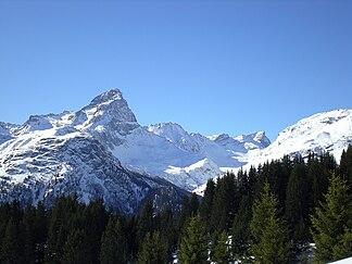
Oberhalbsteiner Alps
| Plateau group
Oberhalbsteiner Alps
|
|
|---|---|
|
Piz Platta in winter |
|
| Highest peak | Piz Platta ( 3392 m above sea level ) |
| location | Graubünden ( Switzerland ), Province of Sondrio ( Italy ) |
| Classification according to |
AVE : 64 SOIUSA : 15.I |
| Coordinates , ( CH ) | 46 ° 31 ' N , 9 ° 31' O ( 758 987 / 154 516 ) |
The Oberhalbsteiner Alps are a mountain group near Avers . The AVE uses the name Plattagruppe synonymously for this area . According to SOIUSA , they are referred to as the Platta Alps or, based on the SAC guide “Avers”, also called Avers mountains . The area is bounded in the north from Splügenpass to Thusis by the Hinterrhein and to Tiefencastel by the Albula and in the east by the Julia up to the Septimer . The western and southern borders form the Liro and the Maira up to the confluence in Chiavenna . The highest point in the region is the Piz Platta ( 3392 m above sea level ). He is named for the alpine club section "Piz Platta SAC" of the area.
Geologically, the entire area (Suretta cover) belongs to the Penninic and not to the Eastern Alps and is assigned to the Adula Alps from this perspective . By dividing the Alps on the Splügen in two into Eastern and Western Alps, this thematic summary was dissolved. The SAC guide Bündner Alpen 3 "Avers" describes the entire area between the Septimer Pass and the San Bernardino Pass .
In the north the Plessur Alps , in the east the Albula Alps , in the south the Bernina Alps , in the west the Tambogroup and in the northwest the Adula Alps meet this mountain group.
Subgroups
- Suretta group
between Splügenpass and Pass da Niemet - Piz Timun chain
between Pass da Niemet and Passo di Angelago - Pizzo Stella group
between Passo di Angelago and Passo di Lei - Chain Schiahorn - Piz Galaguin
between Passo di Lei and Passo da la Prasgnola -
Piz Duan group
south of the Pass della Val da Roda - Tscheischhorn chain
from Bergalga pass between Madrischer Rhein and Bergalgabach and Averser Rhein - Chain Gletschhorn - Piz Piot
between Bergalga Pass and Jufer Joch bordered by Bergalgabach, Jufer Rhein and Val da la Duana - Piz Turba - Piz Scalotta chain
between Fuorcla da Faller (north of Juf ), Jufer Joch and Pass da Sett - Piz Platta group
between Fuorcla Curtegns and Juf - Forbesch - Ablatsch massif
from Fuorcla Curtegns between Ava da Faller and Val Curtegns - Piz Grisch group
south of the Pass da Schmorras - Piz Curvér group
north of the Pass da Schmorras
literature
- Club guide SAC: Bündner Alpen 3, Avers (San Bernardino to Septimer)
- List of mountain groups in the Eastern Alps (according to AVE) - detailed breakdown
- Sergio Marazzi: La “Suddivisione orografica internazionale unificata del Sistema Alpino” (SOIUSA) - the complete article with detailed illustrations (PDF; 1.52 MB, Italian)
Web links
Individual evidence
- ^ History | SAC Piz Platta Website of the SAC section Piz Platta. Retrieved December 21, 2015.


