
Piz Platta
| Piz Platta | ||
|---|---|---|
 Piz Platta in winter |
||
| height | 3392 m above sea level M. | |
| location | Canton of Graubünden , Switzerland | |
| Mountains | Oberhalbsteiner Alps | |
| Dominance | 11.66 km → Piz Calderas | |
| Notch height | 1108 m ↓ Julier Pass | |
| Coordinates | 763 013 / 150569 | |
|
||
| First ascent | November 7, 1866 by Arnold Baltzer, BE de Bernonville and Gadient with Stephan Hartmann | |
| Normal way | Through the southwest flank of the Averstal; Via the Vadret da Piz Platta from the Oberhalbstein | |
| particularities | Namesake of the Piz Platta group , the Platta Alps and the SAC section Piz Platta | |
 Summit cross on the Piz Platta |
||

The Piz Platta is 3392 m above sea level. M. high mountain in the Oberhalbsteiner Alps in the canton of Graubünden in Switzerland and is located southwest of Mulegns and northeast of Avers . It is the namesake of the Piz Platta group , the Platta Alps and the SAC section Piz Platta .
The guide for ski tours writes: “The Piz Platta is by far the most beautiful ski mountain in Oberhalbstein and perhaps also in Graubünden [...]. Enjoyable descents, especially to Mulegns ”, come with the first-rate view . Thanks to its dominance, especially towards the west, Piz Platta offers an exceptional view of the Bernese and Valais Alps ( Schreckhorn , Lauteraarhorn , Mönch , Finsteraarhorn , Aletschhorn , Nadelhorn , Täschhorn , Alphubel , Dufourspitze or the Gd Gendarme 148.67 km away near Weisshorn ). The most distant visible point ( 44 ° 17 ′ 12 ″ N , 6 ° 58 ′ 54.2 ″ E ) from Piz Platta is, however, in a south-westerly direction at the Cima della Rocca Rossa ( 1959 m slm ), 67 km north of Nice on the border between the Italian Piedmont and the French region Provence-Alpes-Côte d'Azur and is 317 km away.
Location and surroundings
The Piz Platta is namesake and the highest elevation of the Piz Platta group , a sub -group of the Oberhalbsteiner Alps . The summit is in the municipality of Surses . The border with Avers is 350 m southwest of the summit. The Piz Platta is bordered in the north by the Val Gronda , in the northeast by the Val Faller , in the east by the Val Bercla and in the southwest by the Averstal . The Val Gronda, the Val Faller and the Val Bercla are side valleys of the Oberhalbstein and the Averstal is a side valley of the Hinterrhein .
The neighboring peaks include Piz Forbesch , Piz Scalotta , Piz Surparé , Tälihorn , Inner- , Mittler- and Usser-Wissberg as well as Piz Cagniel .
The Piz Platta has a glacier in the northwest and the Vadret da Piz Platta in the south.
Valley locations are Mulegns in Oberhalbstein and Cresta in Averstal. A frequent starting point is Tga in the Val Faller, above Mulegns.
Routes to the summit
Summer routes
Through the southwest flank
Usual route from Averstal (with glacier inspection)
- Starting point: Cresta ( 1959 m )
- Difficulty: L
- Time required: 4½ hours
Through the south couloir

- Starting point: Cresta ( 1959 m )
- Difficulty: L
- Time required: 4½ hours
Through the snow couloir of the north-west wall and over the south-west ridge
The route requires favorable snow conditions in the channel. If the conditions are bad, the variant over the entire west ridge comes into consideration.
- Starting point: Mulegns ( 1481 m ) or Tga ( 1927 m )
- Difficulty: ZS
- Time required: 6¾ hours from Mulegns or 5½ hours from Tga
Over the entire west ridge
- Starting point: Mulegns ( 1481 m ) or Tga ( 1927 m )
- Difficulty: ZS
- Time required: 7¼ hours from Mulegns or 6 hours from Tga
Over the north ridge
The mighty north face looks better from a distance than it actually is, because some of its rock is deceptively loose.
- Starting point: Mulegns ( 1481 m ) or Tga ( 1927 m )
- Difficulty: S
- Time required: 9¼ hours from Mulegns or 8 hours from Tga
Over the northeast ridge
Shortest route from Tga, recommended in favorable conditions on the north face. Typical deer pass.
- Starting point: Mulegns ( 1481 m ) or Tga ( 1927 m )
- Difficulty: WS +
- Time required: 5¾ hours from Mulegns or 4½ hours from Tga
Over the upper band of the north wall
The route has not been used recently.
- Starting point: Mulegns ( 1481 m ) or Tga ( 1927 m )
- Difficulty: ZS (?)
- Time required: 5¾ hours from Mulegns or 4½ hours from Tga
Through the Val Bercla
- Starting point: Mulegns ( 1481 m ) or Tga ( 1927 m )
- Difficulty: WS +
- Time required: 6¼ hours from Mulegns or 5 hours from Tga
Through the eastern flank
Route is no longer used because the uppermost glacier has disappeared
- Starting point: Mulegns ( 1481 m ) or Tga ( 1927 m )
- Difficulty: WS +
- Time required: 6½ hours from Mulegns or 5¼ hours from Tga
Over the southeast ridge
The route is not recommended due to the lack of cheap snow.
- Starting point: Mulegns ( 1481 m ) or Tga ( 1927 m )
- Difficulty: WS (?)
- Time required: 6½ hours from Mulegns or 5¼ hours from Tga
Via the Vadret da Piz Platta


Usual route from Oberhalbstein
- Starting point: Mulegns ( 1481 m ) or Tga ( 1927 m )
- Difficulty: L
- Time required: 5¾ hours from Mulegns or 4½ hours from Tga
Winter routes
The transition from Avers to Oberhalbstein is particularly rewarding. The Piz Platta may only be approached in safe conditions, and alpine experience is required on the summit (up to 45 ° at 150 m)
From Avers Cresta or Pürt
- Starting point: Cresta ( 1959 m ) or Pürt ( 1921 m )
- Exposures: SW, W
- Difficulty: S
- Time required: 5 hours
- Comment: On foot through the 45 ° steep couloir north of P. 3140. Depending on the route, ski depot at ( 3150 m ) or ( 3240 m ).
- Departure: ascent route or to Mulegns
From Mulegns or Tga
- Starting point: Mulegns ( 1481 m ) or Tga ( 1927 m )
- Via: Val Bercla, terrace of Platta, Platta glacier
- Exposures: E, NW
- Difficulty: ZS
- Time required: 6½ hours from Mulegns or 5 hours from Tga
- Comments: Depending on the route chosen, ski depot at ( 3150 m ) or ( 3240 m ).
- Descent: ascent route or from Val Bercla via a small counter-climb (240 m) to Muttans ( 2440 m ) and then to the dam of the Lai da Marmorera ( 1684 m ) or even to Scalotta ( 1602 m ). Alternatively, you can descend from Muttans via Alp Motta to Stalveder ( Bivio , 1710 m ), but this is indicated in the guide as "not worthwhile" .
panorama

gallery
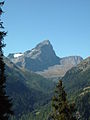
Piz Platta, taken from the Oberhalbstein .

Piz Platta, recorded from Piz Forbesch .
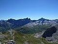
Piz Arblatsch , Piz Forbesch and Piz Platta (from left to right), taken by Piz digl Gurschus .

View in northeast direction of the Albula Alps .


literature
- Manfred Hunziker: Club Guide, Bündner Alpen, Volume 3 (obverse) 1st edition. Verlag des SAC, 1994, ISBN 3-85902-140-0 , pp. 243-249.
- Georg Calonder: Alpine Skitouren, Volume 2 (Graubünden) 4th edition. Verlag des SAC, 1992, ISBN 3-85902-060-9 , pp. 159-161.
- Vital Eggenberger: Ski tours Graubünden South. Verlag des SAC, 2010, ISBN 978-3-85902-301-7 , pp. 98-100.
- National map of Switzerland, sheet 1256 Bivio, 1: 25000, Federal Office of Topography, edition 2003
Web links
- Piz Platta on Peakbagger.com (English)
- Calculated 360 ° panorama from Piz Platta
- www.hikr.org Various tour reports
- www.summitpost.org Various tour reports
Individual evidence
- ↑ History of the SAC Piz Platta . Retrieved December 21, 2015.
- ↑ Calculated 360 ° panorama ( U. Deuschle ; information ) from Piz Platta