
Usser Wissberg
| Usser Wissberg | ||
|---|---|---|
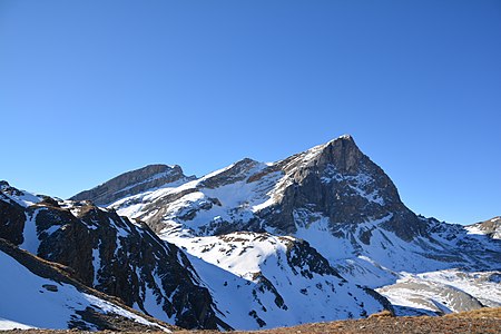
 Usser Wissberg, taken from Murter . |
||
| height | 3052 m above sea level M. | |
| location | Canton of Graubünden , Switzerland | |
| Mountains | Oberhalbsteiner Alps | |
| Dominance | 2.82 km → Piz Platta | |
| Notch height | 236 m ↓ Tälifurgga | |
| Coordinates | 759 765 / 151 299 | |
|
||
| First ascent | Gottfried Ludwig Theobald , 1859 | |
 Summit of the Usser Wissberg |
||

The Usser Wissberg is a mountain north of Cresta ( Avers ) in the canton of Graubünden in Switzerland with an altitude of 3,052 m above sea level. M. It is part of the (Crester) Wissberge, a massif extending from southeast to northwest with Inner Wissberg ( 2947 m ) in the southeast, Mittler Wissberg ( 3001 m ) in the middle and Usser Wissberg in the northwest. The massif has various other culmination points not named on the national map . The massif takes its name from the whitish-yellow color of the marble-like calcite veins that run through the light gray limestone.
Location and surroundings

The Usser Wissberg belongs to the Piz Platta group , a sub -group of the Oberhalbsteiner Alps . At the summit, the municipal boundaries between Ferrera , Avers and Surses meet . The Usser Wissberg is bordered in the east by the Val Gronda , a side valley of the Val Faller , in the south by the Averstal and in the north-west by the Val Starlera .
The neighboring peaks include the Mittlerer and Inner Wissberg in the southeast, the Piz Platta in the east, the Forbesch-Arblatsch massif with Piz Cagniel and Piz Forbesch in the northeast and the Piz Grisch group with Murter , Piz Mez and Piz Alv in the north . South of the Usser Wisshorn, on the other side of the Averstal, is the Grosshorn.
The farthest visible point ( 44 ° 9 '52.1' N , 7 ° 13 '24 " O ) is from Usser Wissberg 200 m north of the Pointe Giegn in French Department Alpes-Maritimes , region Alpes-Cote d' Azure . The Pointe Giegn belongs to the Mercantour Mountains and is only 650 m south of the border with Italy . The point is 315 km away from the Usser Wissberg.
On the eastern flank of the Usser Wissberg had a glacier, the Wissberggletscher , which has now almost completely melted away.
Talort is Cresta. Common starting points are radons and tga.
Stone hut on the east flank

East of the Usser Wissberg is the unlisted P. 2995 on the national map and on its eastern flank a small stone hut. The hut was built by the soldiers in World War I and was used as accommodation for them. The ascent to the hut from Fuorcla Curtegns is marked with wooden posts (also from the time of the First World War). Nowadays the hut is only used by hunters during the Graubünden high hunt .
Routes to the summit
Summer routes
Over the east ridge
- Starting point: Cresta ( 1959 m ), Radons ( 1866 m ) or Mulegns ( 1481 m )
- Via: Tälifurgga ( 2817 m )
- From Cresta via Täli to Tälifurgga
- From Radons via Fuorcla Starlera , Fuorcla Curtegns to Tälifurgga
- From Mulegns via Tga, Faller, Val Gronda to Tälifurgga
- Difficulty: L , up to Tälifurgga as trail white-red-white highlighted
- Time required: (1 hour from Tälifurgga)
- 3¼ hours from Cresta
- 5 hours from Mulegns (4 hours from Tga)
- 4½ hours from radons
- First ascent: Gottfried Ludwig Theobald , 1859
Over the Crester Alp
Recommended as a quick descent route, especially if there is still snow in the hollow.
Over the southwest ridge
The route uses a flat, steep slope covered with a lot of loose debris and is, if at all, only to be climbed in the descent.
- Destination: Hüreli
- Difficulty: WS
- Time required: ¾ hours in the descent
- First ascent: A. Attenhofer, August 28, 1894 on the descent
About the northeast spur

- Starting point: Radons ( 1866 m ) or Mulegns ( 1481 m )
- Via: Fuorcla Curtegns
- Difficulty: WS - S until Fuorcla Curtegns as trail white-red-white highlighted
- Time required: 5 hours from Mulegns (4 hours from Tga) or 4½ hours from Radons
- Alternative: Either through the eastern flank or via Steinhütte
- Note: The way to the stone hut is marked with wooden markings from the First World War.
- First ascent: William Augustus Brevoort Coolidge with Christian Almer , August 30, 1894
Winter routes
From Cresta
- Starting point: Casol ( 1920 m ) near Cresta
- Via: Crester Alpa, P. 2997
- Exposures: S
- Difficulty: ZS +
- Time required: 3½ hours
About radons
- Starting point: Radons ( 1866 m )
- Via: Val Curtegns , Fuorcla Starlera , Fuorcla Curtegns , very steep eastern flank
- Exposures: N, E
- Difficulty: S-
- Time required: 4½ hours
- Comment: To Radons from Savognin with the mountain railways from Savognin Bergbahnen .
From Mulegns
- Starting point: Mulegns ( 1482 m )
- Via: Tga, Val Faller , Val Gronda almost to Fuorcla Curtegns , then over the steep eastern flank
- Exposures: NE, N
- Difficulty: S-
- Time required: 5 hours
panorama

gallery

Blich to the southeast to Mittler - (left) and Inner Wissberg (right)

View to the east to Piz Platta
Usser Wissberg, recorded by the Fuorcla Curtegns


literature
- Manfred Hunziker: Club guide, Bündner Alps . Obverse. 1st edition. tape III . Verlag des SAC, 1994, ISBN 3-85902-140-0 , p. 253-255 .
- Vital Eggenberger: Ski tours Graubünden South . Verlag des SAC, 2010, ISBN 978-3-85902-301-7 , pp. 102-104 .
- National map of Switzerland, sheet 1255 Splügenpass, 1: 25,000, Federal Office of Topography, 2012 edition.
- National map of Switzerland, sheet 1256 Bivio, 1: 25,000, Federal Office of Topography, 2015 edition.
Web links
- 360 ° panorama from the Usser Wissberg
- Tour reports on www.hikr.org
Individual evidence
- ↑ Calculated 360 ° panorama ( U. Deuschle ; notes ) from the Usser Wissberg