
Fuorcla Curtegns
| Fuorcla Curtegns | |||
|---|---|---|---|

|
|||
| Compass direction | west | east | |
| Pass height | 2657 m above sea level M. | ||
| Canton | Graubünden , Switzerland | ||
| Watershed | Ava da Curtegns (Ava da Nandro, Schletg, Gelgia , Albula , Hinterrhein , Rhein ) ---- Ragn da Ferrera ( Hinterrhein , Rhein ) |
Ragn da Val Gronda (Ragn da Faller, Gelgia , Albula , Hinterrhein , Rhine ) | |
| Valley locations | Radons ---- Innerferrera |
Mulegns | |
| expansion | trail | ||
| Mountains | Oberhalbsteiner Alps | ||
| profile | |||
| Ø pitch |
9.4% (791 m / 8.43 km) ---- 12.5% (1.176 m / 9.42 km) |
12.3% (1175 m / 9.52 km) | |
| map | |||
|
|||
| Coordinates | 760 672 / 152 327 | ||

The Fuorcla Curtegns ( Rhaeto-Romanic fuorcla, furschela from the Latin furcula for 'small fork, small mountain passage' and Curtegns to Rhaeto-Romanic in the idiom Surmiran plural from curtegn for 'Baumgarten, enclosed property') is an Alpine pass in the Swiss canton of Graubünden . With a peak height of 2657 m above sea level. M. He connects via the Val Starlera the Averstal in the west, over the Val Curtegns the Val Nandro in the north and the Val Gronda and Val Faller the Oberhalbstein the east. The pass is located west of Mulegns and east of Innerferrera .
Location and surroundings
The Fuorcla Curtegns belongs to the Forbesch-Arblatsch massif, a sub-group of the Oberhalbsteiner Alps . The municipal boundary between Surses and Ferrera runs over the pass . It is the transition from the Val Curtegns ( Savognin , Radons in the Val Nandro ) to the Val Gronda ( Mulegns , Tga in the Val Faller ). The main watershed between Surses and Avers runs only around 50 m west of the pass, which is why the Fuorcla Curtegns is also the transition from the Val Gronda to the Val Starlera ( Innerferrera in the Averstal ).
The Fuorcla Curtegns connects the Piz Cagniel ( 2975 m ) in the northeast with the Usser Wissberg ( 3052 m ) in the southwest.
Routes to the pass

Through the Val Curtegns
- Starting point: Radons ( 1893 m )
- Via: Val Curtegns past the Fuorcla Starlera
- Difficulty: B than trail white-red-white marks
- Time required: 3 hours
Through the Val Gronda
- Starting point: Mulegns ( 1481 m ) or Tga ( 1927 m )
- Via: Val Faller, Val Gronda
- Difficulty: B than trail white-red-white marks
- Time required: 3½ hours from Mulegns, 2½ hours from Tga
Over the western debris fields
- Starting point: Cresta ( 1959 m )
- Via: Sattel ( 2719 m ) between Usser Wissberg and Hüreli
- Difficulty: EB
- Time required: 2¼ hours
Through the Val Starlera
- Starting point: Innerferrera ( 1481 m )
- Via: Fuorcla Starlera ( 2516 m )
- Difficulty: B than trail white-red-white marks
- Time required: 4 hours
About the Tälifurgga
- Starting point: Cresta ( 1959 m )
- Via: Tälifurgga ( 2822 m )
- Difficulty: EB , as trail white-red-white marks
- Time required: 2¾ hours
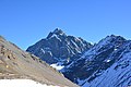
gallery
View to the east to Piz Platta .

Looking north to Piz Cagniel .

View to the southwest to the Usser Wissberg .

View to the south to the Tälifurgga .


literature
- Manfred Hunziker: Club guide, Bündner Alps . Obverse. 1st edition. tape III . Verlag des SAC, 1994, ISBN 3-85902-140-0 , p. 257-259 .
- National map of Switzerland, sheet 1256 Bivio, 1: 25,000, Federal Office of Topography, 2015 edition.
Web links
Individual evidence
- ↑ Andrea Schorta: How the mountain got its name . Small Rhaetian name book with two and a half thousand geographical names of Graubünden. Terra Grischuna Verlag, Chur and Bottmingen / Basel 1988, ISBN 3-7298-1047-2 , p. 89 .
- ↑ Andrea Schorta: How the mountain got its name . Small Rhaetian name book with two and a half thousand geographical names of Graubünden. Terra Grischuna Verlag, Chur and Bottmingen / Basel 1988, ISBN 3-7298-1047-2 , p. 82 .