
Piz Cagniel
| Piz Cagniel | ||
|---|---|---|
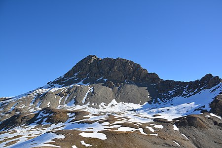
 Piz Cagniel captured by radons |
||
| height | 2975 m above sea level M. | |
| location | Canton of Graubünden , Switzerland | |
| Mountains | Oberhalbsteiner Alps | |
| Dominance | 1.71 km → Piz Forbesch | |
| Notch height | 226 m ↓ Fuorcla Cagniel | |
| Coordinates | 761 214 / 152 875 | |
|
||

The Piz Cagniel (hardly from the older Rhaeto-Romanic cugniel , diminutive to cugn , Latin cuneus for 'wedge', but rather syncopated from Rhaeto-Romanic calcagniel , diminutive to calcogn , Latin calcaneum for 'heel') is a mountain west of Mulegns in the canton of Graubünden in the Switzerland with an altitude of 2975 m above sea level. M.
Location and surroundings

The Piz Cagniel is the southwest end of the Forbesch-Arblatsch massif , a subgroup of the Oberhalbsteiner Alps . It is located entirely in the municipality of Surses . The Piz Cagniel is bordered in the north by the Val Curtegns , a side valley of the Val Nandro and in the southeast by the Val Gronda , a side valley of the Val Faller . Both are in turn side valleys from the Oberhalbstein .
The neighboring peaks include Piz Forbesch and Piz Arblatsch in the northeast, Piz Platta in the southeast, Usser Wissberg in the southwest and Murter and Piz Mez in the northwest. South of Piz Cagniel is the Fuorcla Curtegns , west of the Fuorcla Starlera and northeast the Fuorcla Cagniel .
The farthest visible point ( 48 ° 14 '43 " N , 9 ° 29' 17.6" O ) is exactly north a hill at the Piz Cagniel Zwiefalten , a community in the district of Reutlingen about halfway between Stuttgart and Lake Constance . The point is 193 km from Piz Cagniel.
The valley location is Mulegns, where radon starts frequently in the Val Nandro, Tga in the Val Faller or Ausserferrera in the Averstal .
Routes to the summit
Over the northeast ridge
- Starting point: Mulegns ( 1482 m ), Tga ( 1927 m ) or Radons ( 1893 m )
- Via: Fuorcla Cagniel
- Difficulty: WS
- Time required: 4¼ hours from Mulegns, 3¼ hours from Tga or 3¾ hours from Radons (50 min from Fuorcla Cagniel)
Over the west ridge
- Starting point: Mulegns ( 1482 m ), Tga ( 1927 m ), Radons ( 1893 m ), Cresta ( 1959 m ) or Innerferrera ( 1481 m )
- Via: Fuorcla Curtegns
- Difficulty: WS , to Fuorcla Curtegns as trail white-red-white highlighted
- Time required: 4¾ hours from Mulegns, 3¾ hours from Tga, 4¼ hours from Radons, 3½ hours from Cresta or 5¼ hours from Innerferrera (1¼ hours from Fuorcla Curtegns)
- Note: For routes to Fuorcla Curtegns see the article Fuorcla Curtegns .
gallery
View from Fuorcla Curtegns to Piz Cagniel.

View from Crap Farreras , Piz Mez in the middle , Piz Cagniel to the left.


literature
- Manfred Hunziker: Club guide, Bündner Alps . Obverse. 1st edition. tape III . Verlag des SAC, 1994, ISBN 3-85902-140-0 , p. 259-260 .
- National map of Switzerland, sheet 1256 Bivio, 1: 25,000, Federal Office of Topography, 2015 edition.
Web links
- 360 ° panorama from Piz Cagniel
- Tour reports on www.hikr.org
Individual evidence
- ↑ Andrea Schorta: How the mountain got its name . Small Rhaetian name book with two and a half thousand geographical names of Graubünden. Terra Grischuna Verlag, Chur and Bottmingen / Basel 1988, ISBN 3-7298-1047-2 , p. 71 .
- ↑ Calculated 360 ° panorama ( U. Deuschle ; information ) from Piz Cagniel