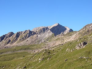
Piz Alv (Oberhalbsteiner Alps)
| Piz Alv | ||
|---|---|---|
|
Piz Alv, taken from Alp Schmorras to the northeast |
||
| height | 2,854.5 m above sea level M. | |
| location | Canton of Graubünden , Switzerland | |
| Mountains | Oberhalbsteiner Alps | |
| Dominance | 1.38 km → Piz Grisch | |
| Notch height | 146 m ↓ ridge between Piz Alv and Piz Grisch | |
| Coordinates | 757 595 / 154 810 | |
|
|
||
|
Summit cross. Piz Grisch in the background |
||
The Piz Alv ( Rhaeto-Romanic for Weissespitze ) is a mountain east of Innerferrera in the canton of Graubünden in Switzerland with a height of 2854.5 m above sea level. M.
Location and surroundings
The Piz Alv belongs to the Piz Grisch group , a sub -group of the Oberhalbsteiner Alps . The municipal boundary between Ferrera and Surses runs over the summit . The Piz Alv is bordered in the northeast by the Val Schmorras , in the south by the Val Starlera and in the northwest by the Alp Mos.
The neighboring peaks include the Piz Settember , the Piz Mez , the Guggernüll and the Piz Grisch .
Valley locations are Ausserferrera and Innerferrera . A common starting point is radon.
Routes to the summit
Through the eastern flank
- Starting point: Radons ( 1866 m )
- Route: Via Schmorras
- Difficulty: EB
- Time required: 3½ hours
Over the south ridge
- Starting point: Innerferrera ( 1480 m ) or Fuorcla da Saletscha ( 2619 m )
- Difficulty: EB / BG to Fuorcla da Saletscha, then L
- Time required: 3½ hours from Innerferrera, ¾ hours from Fuorcla da Saletscha
Over the west ridge
- Starting point: Ausserferrera ( 1300 m )
- Route: Via Alp Mos
- Difficulty: L
- Time required: 4¼ hours
Winter route
- Starting point: Radons ( 1866 m , accessible with the Savognin Bergbahnen lifts )
- Route: Samnecs, via Ava da Schmorras to the valley background and then to the northeast ridge
- Difficulty: intermediate skier
- Time required: 4 hours
photos
Piz Alv, taken from the Heidi slope ( Savognin ski area ).
View towards Savognin in the Val Nandro . In the background the Bergüner sticks .
From Pizzo Badile via Pizz Gallagiun to Pizzo Stella and Lago di Lei .
View of Lago di Lei , in the background including Pizzo Stella and Piz Timun .
Web links
literature
- Manfred Hunziker: Club Guide, Bündner Alpen, Volume 3 (obverse) 1st edition. Verlag des SAC, 1994, ISBN 3-85902-140-0 , p. 276.
- Georg Calonder: Alpine Skitouren, Volume 2 (Graubünden) 4th edition. Verlag des SAC, 1992, ISBN 3-85902-060-9 , p. 164.
- National map of Switzerland, sheet 1255 Splügenpass, 1: 25000, Federal Office of Topography, edition 2001


