
Val Schmorras
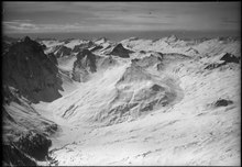
The Val Schmorras is a valley in the Swiss canton of Graubünden near Radons in the municipality of Surses . It is 5.7 km long and up to 3.3 km wide.
The Val Nandro valley is a left side valley of the Oberhalbstein and extends from Savognin to Radons, where it is divided into two side valleys: the right side Val Curtegns and the left side Val Schmorras. The Val Schmorras stretches from Alp Curtegns near Radons ( 1852 m ) to the Fuorcla da Saletscha pass ( 2616 m ). Innerferrera in the Averstal can be reached via the Fuorcla da Saletscha . In addition, the Fuorcla Cotschna ( 2515 m ) and the Pass da Schmorras ( 2564 m ) lead from the valley to Ausserferrera . The valley is enclosed on the left by Piz Alv ( 2855 m ) and Piz Settember ( 2728 m ) and on the right by Murter ( 2752 m ) and Piz Mez ( 2717 m ). The Lai da Schmorras is located in the Val Schmorras .
The Val Schmorras is traversed by the Ava da Schmorras , which at Radons flows together with the Ava da Curtegns and under the name Ava da Nandro and later Schletg . The brook flows into the Julia at Savognin .
Alp Nova and Alp Schmorras are located in Val Schmorras . At 2278 m , Alp Schmorras was the highest cow alp in Europe. Nowadays the alp is used as a cattle alp.
literature
- Manfred Hunziker: Club guide, Bündner Alps . Obverse. 1st edition. tape III . SAC publishing house, 1994, ISBN 3-85902-140-0 .
- National map of Switzerland, sheet 1256 Bivio, 1: 25,000, Federal Office of Topography, 2015 edition.
- National map of Switzerland, sheet 1255 Splügenpass, 1: 25,000, Federal Office of Topography, 2012 edition.
Web links
Coordinates: 46 ° 32 '33.5 " N , 9 ° 31' 12.1" E ; CH1903: seven hundred and fifty-nine thousand six hundred thirty-four / 156 712