Piz Mez
| Piz Mez | ||
|---|---|---|
|
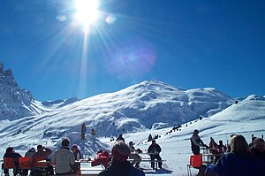
Piz Mez, recorded by radons |
||
| height | 2718.1 m above sea level M. | |
| location | Canton of Graubünden , Switzerland | |
| Mountains | Oberhalbsteiner Alps | |
| Dominance | 1.81 km → Murter | |
| Notch height | 72 m ↓ Murter ridge | |
| Coordinates | 760561 / 155 761 | |
|
|
||
| Normal way | About radons | |
| particularities | Popular ski mountain | |
|
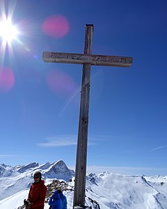
Summit cross on the Piz Mez |
||
The Piz Mez ( Rhaeto-Romanic in the idiom Surmiran for "middle peak " from the Latin medius ) is a mountain south of the Savognin ski area in the canton of Graubünden in Switzerland with a height of 2718.1 m . Thanks to its proximity to the ski area and the long and wide north slope with a regular slope, it is a popular ski mountain. He is often wrongly referred to as Murter . Murter ( Rhaeto-Romanic in the Idiom Surmiran for "alpine pasture", from the Latin mortarium " mortar , high alpine pasture, especially sheep pasture") is the ridge that separates the Val Curtegns from the Val Schmorras , and the northern corner of which is the Piz Mez.
Location and surroundings
The Piz Mez belongs to the Piz Grisch group , a sub -group of the Oberhalbsteiner Alps . It lies entirely within the municipality of Surses .
The neighboring peaks include the Piz Arlos , the Piz Arblatsch , the Piz Forbesch , the Piz Cagniel , the Murter , the Piz Alv , the Piz Settember , the Sur Carungas , the Piz Cartas and the Piz Martegnas .
The most distant visible peak from Piz Mez is the 85.7 km distant Galenstock ( 3586 m , Urner Alps ), which is located north of the Furka Pass on the border of the cantons of Uri and Valais .
The Savognin ski area is located north of Piz Mez.
Valley locations are Riom, Parsonz and Savognin. A common starting point is radon.
Routes to the summit
Summer routes
Via Alp Curtegns
- Starting point: Radons ( 1866 m )
- Difficulty: EB
- Time required: 2½ hours
About Alp Nova
- Starting point: Radons ( 1866 m )
- Difficulty: EB
- Time required: 2½ hours
winter
- Starting point: Radons ( 1866 m )
- Via: Alp Curtegns, P. 2106, north-east ridge or east flank
- Exposures: NE
- Difficulty: L
- Time required: 2½ hours
- Descent along the ascent track or from the summit over the northern slope into the Nurclanga hollow
panorama
gallery
Piz Mez, recorded by Piz Martegnas
Piz Mez on an aerial photograph in 1949
View of Piz Forbesch
View of Savognin , Cunter , Piz Mitgel and Lenzer Horn
literature
- Manfred Hunziker: Club Guide, Bündner Alpen, Volume 3 (obverse) 1st edition. Verlag des SAC, 1994, ISBN 3-85902-140-0 , pp. 274-275.
- Georg Calonder: Alpine Skitouren, Volume 2 (Graubünden) 4th edition. Verlag des SAC, 1992, ISBN 3-85902-060-9 , p. 163.
- Vital Eggenberger: Ski tours Graubünden South . Verlag des SAC, 2010, ISBN 978-3-85902-301-7 , pp. 106 .
Web links
- Panorama from Piz Mez
- www.hikr.org Various tour reports
Individual evidence
- ↑ Andrea Schorta: How the mountain got its name . Small Rhaetian name book with two and a half thousand geographical names of Graubünden. Terra Grischuna Verlag, Chur and Bottmingen / Basel 1988, ISBN 3-7298-1047-2 , p. 104 .
- ↑ Andrea Schorta: How the mountain got its name . Small Rhaetian name book with two and a half thousand geographical names of Graubünden. Terra Grischuna Verlag, Chur and Bottmingen / Basel 1988, ISBN 3-7298-1047-2 , p. 108 .
- ↑ Calculated 360 ° panorama ( U. Deuschle ; information ) from Piz Mez


