
Aerial photography


As aerial photography (also aerial photography ) is referred to a photographic or technical Genre, in which photographic images of the terrain from the bird's-eye view or from aircraft to be customized; one then speaks of aerial photographs or aerial photographs . The branch that deals with the production of aerial photographs is also referred to as aerial photography , its evaluation as aerial photograph measurement or photogrammetry .
Thematically related genres are kite aerial photography (from tethered kites), carrier pigeon photography , orbital photography , the creation of satellite images and astrophotography .
Shooting angle
Oblique images
Oblique or tilted images serve as an artistic photographic view for architecture and landscape shots for remote sensing . From this, 3D images can also be generated by means of photogrammetry , for example for three-dimensional city maps, for terrain models or for computer games. If the camera is inclined at an angle of 5–15 ° compared to the plumb line, one speaks of a steep angle, up to 60 ° of an oblique image and up to 90 ° of a flat image, whereby these mostly show the horizon.
Perpendicular images
Geo-referenced perpendicular images are used for cartography. They are recorded from an airplane as an aerial image or from a satellite as a satellite image . Vertical recordings are planned as nadir recordings, with the incident light entering the camera perpendicularly . In practice, however, a deviation of approx. 1–4 ° is achieved. For the free map project OpenStreetMap , orthophotos are the most important data source. For stereoscopy and quantitative evaluations (Höheneinmessung, mapping vertical photographs are exclusively used).
Overflight and evaluation
In accordance with the intended evaluation of aerial photographs, the airlines are precisely planned in terms of position and altitude for an aerial flight. The aerial survey of a landscape made either to individual images to make certain objects, or to systematically capture a wider area. In this case, parallel stripes with 30-60% coverage of the recordings are usually flown.
The images can be made as analog or digital recordings . The evaluation can be done analog ( single image evaluation or stereo photogrammetry ) or digitally with the appropriate software. In this case, analog images must first be digitized with a scanner . In order for aerial images to be used in a GIS , they must first be rectified (single image rectification or creation of an orthophoto from two images with different angles).
The advantages of aerial photographs over satellite photographs are not only in the higher resolution (up to 3 cm per image pixel depending on the flight altitude), but also in the fact that one usually receives cloud-free images, since the aircraft normally fly under the cloud cover (exception: soaring spy aircraft like the Lockheed U-2 ) or, if the weather is suitable, can fly while the satellite follows a fixed orbit .
When using chemical infrared film in conjunction with strong red filters, it is easier for haze / fog to penetrate and enormous recording distances in side / oblique view are possible because the infrared radiation is not deflected by the water molecules as strongly as visible light. The recordings made are only available a certain time after landing, whereby analogue photo films still have to be developed.
Areas of application

Important areas of application for aerial photography are e.g. B .:
- Photogrammetry
- Geography , geology and cartography
- Espionage and military (air and terrain) reconnaissance
- Localization of bombs unintentional by evaluating war aerial photographs and aeromagnetics
- Postcards , brochures
- Sale of aerial photos (unordered from helicopters) of houses to their owners, including company premises, restaurants (around 1960–1985)
- Urban planning and landscaping
- Construction planning
- Industrial inspection
- Species protection and plant protection
- measurement
- Advertising and image brochures, TV coverage
- Aerial archeology, in particular using infrared photography
Development and history

The French photographer Nadar took his first aerial photos in 1858 from a tethered balloon . The oldest known German aerial photographs date from 1886 by Hugo vom Hagen . In 1915, the first in-line measuring chambers for aerial photography were constructed. While aerial photography was used in the military sector from the start, natural scientists were also interested in the new technology from around 1920.
The first civil organizations and societies emerged in Germany in 1919. In that year, the first German airline, the Deutsche Luft-Reederei , established an aerial photography department. Hansa Luftbild developed from this department . In 1934 this took over the main aerial photography companies, which in fact led to the centralization of civil aerial photography.
The American Talbert Abrams is considered to be one of the pioneers of aerial photography and photogrammetry . He not only took aerial photographs for commercial purposes, such as road construction, but also developed his own cameras and the first aircraft specially built for aerial photography, the Abrams P-1 Explorer , which made its maiden flight in 1937.
Today aerial photography is an essential basis for creating maps. For this purpose, recordings in the perpendicular direction are used.
Another pioneer of aerial photography was the Swiss Georg Gerster ( The world saves Abu Simbel ) in the 1960s . At the beginning of the 20th century are the aerial photographs of Central Germany by Ernst Wandersleb important. In the past few years, aerial photos have become particularly popular due to the work of Yann Arthus-Bertrand ( The Earth from Above ) and the large-scale availability of free map data, such as Google Earth or Microsoft Windows Live Local ("Bing Maps" since 2009).
Aerial photography with model aircraft and unmanned aerial vehicles


Aerial photographs can also be taken from unmanned aerial vehicles . From 1900, Alfred Maul constructed a rocket with a built-in camera in Dresden, which was able to take some aerial photographs after its launch. The camera was triggered by a time fuse with a fuse and returned to earth on a parachute .
For military purposes, aerial photographs for reconnaissance purposes have been carried out by unmanned, remote-controlled aircraft, the so-called drones , since the 1930s . For some years now, these drones have also been available to private individuals and use. The technology of aerial photography of model aircraft is also of great interest to hobbyists: in addition to the possibility of accommodating a remote-controlled photo camera, a film or video camera in a suitable flight model (remote-controlled aircraft, captive balloon , kite, model rocket), there is also the Astrocam rocket camera from the Estes company .
The Astrocam is a model rocket that can be operated with propellants that can be flown without a permit in most countries around the world . Its tip has a pocket camera that takes a picture when the parachute is deployed. Only when the Astrocam points to the ground does the subject to be photographed, the area below, come into view. A bit of luck is therefore required for success, because the photographer has no influence on the subject - a real “aerial lomography ” is therefore available. For some time now, the same company has also been offering a model rocket with a built-in digital camera, the so-called Oracle , which can be used to take several aerial photos.
An attractive example of photographs from an unmanned, remote-controlled small airship are the photographs of extensive labyrinths and mazes by the photographer Jürgen Hohmuth that cannot be viewed from the ground .
The hobby aerial photography with model aircraft requires slowly moving devices, the common ones are model helicopters , quadrocopters , motor gliders or motor kites . With the modern compact cameras , which weigh little more than 120 grams (2009), both series recordings and videos can be recorded. Cameras with wide-angle lenses and very short exposure times are preferably used in order to obtain blurred images. For some multicopters, there are stabilized camera mounts, so-called gimbals , which ensure an absolutely shake-free image. Model helicopters have been used successfully in television and cinema productions since the 1980s. However, operating these model helicopters is extremely difficult. A so-called camera operator is also used to operate the camera.
Kite Aerial Photography, or KAP for short, is a type of photography that uses the pull of a kite to move a camera into an airy position. Remote-controlled airships and unmanned tethered balloons are widely used for the creation of aerial images as carriers for remote-controlled camera platforms. The advantages here are the independence from wind and the high payload. The main filling used is helium .
Legal
In the Federal Republic of Germany there was a requirement for a permit for aerial photography until 1990. According to Article 37 of the 3rd Legal Restructuring Act, this authorization requirement for aerial photographs is no longer applicable. However, according to Section 109g (2) of the Criminal Code , military equipment as well as military processes, facilities and installations may not be photographed from aircraft if this endangers “the security of the Federal Republic of Germany or the effectiveness of the troops”.
According to German law, it is also not permitted to use recordings from airplanes or helicopters to penetrate a person's protected privacy , or to publish recordings made in this way without the consent of the person concerned. (BGH, judgment of December 9, 2003, AZ: VI ZR 373/02, - aerial photographs of the holiday home)
In October 2013, the Federal Ministry of Transport, Building and Urban Development published brief information for aerial photographers on the use of unmanned aerial vehicles.
Technical aspects

Depending on the terrain and the type of recordings required, a fixed-wing aircraft, helicopter or unmanned aerial vehicle can be used to create the aerial photo . Due to the comparatively high costs of helicopter missions, their use in contract productions is often limited locally. All German supraregional aerial photography companies therefore mainly work with small aircraft. In the meantime, however, recordings with drones are also gaining ground, which, however, cannot yet keep up with manned aerial photography in terms of height and range.
Pictures from flying passenger planes are often disappointing because they are often blurred (impairment of the autofocus due to the lack of a fixed point) or reproduce a different mood than the one you remember; Apart from the natural haze, this can be related to the coating or soiling of the windows, to any intermediate windows that may be present or to the lighting in the aircraft, the reflections or color characteristics of which can unintentionally enter the picture. At window seats behind the engines of jet engines, the image quality can be impaired by heat shimmer from the exhaust gas jet.
For precisely sharp, print-ready and lecture-ready images of higher resolution, sharpness and color fidelity, the experienced photographer can fall back on a larger camera format, more sensitive films, shorter shutter speeds, adequate filters or even image stabilizers (both for mounting inside the camera and in special lenses). Professional companies work with analog cameras of the film formats 6x6 or 6x7 cm up to the film format 10x12 cm (~ 4x5 inch). Only these cameras enable a quality beyond that of amateurs. In recent years, digital SLR cameras (sensible from 12 megapixels and full-format sensors), but also analog cameras with digital backs (resolution up to around 35 megapixels) have been used more and more. The optical resolution is always diffraction-limited , so that an aircraft at an altitude of one kilometer with an otherwise image-free camera lens with an entrance pupil of 100 millimeters can achieve a maximum optical resolution of a good one centimeter. At higher altitudes, this resolution decreases inversely proportional to the altitude, so that satellites can hardly resolve meter-sized structures.


For cartography , only measurement cameras with film formats of up to 23x23 cm are used, which are installed in specially equipped aircraft with floor hatches pointing straight down. This means that the raw material is flown in from which orthophotos can be generated. For this purpose, airlines are placed over the area to be mapped . These are parallel stretches that - formerly by hand, now with computer support - are arranged in such a way that the photographed areas each two adjacent lines safely overlap at the edges. The trigger points for the camera are determined along the line in such a way that two consecutive images have at least 50% overlap. This guarantees that every point on the ground is visible on at least two images, which is necessary for stereoscopy , i.e. the determination of the height profile. In order to really guarantee coverage and to compensate for errors in aircraft navigation and the triggering precision of the cameras, flights are actually flown with 60% or more coverage. This has the additional advantage that some points are visible in three images, which increases the mathematical stability and thus the accuracy when aligning the images for photogrammetry and during block triangulation .
For some years now, digital large format cameras and medium format cameras have also been used. This achieves floor resolutions of up to 5 cm per pixel. When using helicopters, thanks to slower and lower flight, higher ground resolutions of up to 1 cm are also possible with medium format cameras, but then the image strips are very narrow and flying over larger areas is no longer economical in this way. Such high resolutions are therefore only flown very locally isolated, for example along a road or a high-voltage line. The hilly the terrain, the higher you have to fly, not only in order not to have to fly below the permitted minimum flight altitude , but also because the line width actually photographed decreases with increasing terrain, thus reducing the line spacing and increasing the number of lines required .
Examples

Aerial view of Hamburg
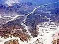
Aerial view of the Sahara

Aerial view of the Electoral Palace in Koblenz during the Federal Garden Show 2011

Aerial view of Schneekoppe in the Czech Giant Mountains

Photo by Wollin , May 1937

The extensively destroyed inner city of Braunschweig ( USAAF aerial photo from May 12, 1945).


Well-known aerial photographers
- Talbert Abrams (1895-1990)
- Ladislaus Almásy (1895–1951)
- Yann Arthus-Bertrand (* 1946)
- Otto Braasch (* 1936)
- Hans Blossey (* 1952)
- Boris Carmi (1914-2002)
- OGS Crawford (1886-1957)
- Hajo Dietz (* 1958)
- Bernhard Edmaier (* 1957)
- Georg Gerster (1928-2019)
- Robert Grahn (* 1964)
- Gerhard Launer (* 1949)
- Klaus Leidorf (* 1956)
- Walter Mittelholzer (1894–1937)
- Nadar (1820-1910)
- Antoine de Saint-Exupéry (1900–1944)
- Eduard Spelterini (1852–1931)
- Paul Straehle (1893–1985)
- Fritz Tiedemann (1915-2001)
- Reimer Wulf (* 1943)
See also
- Orthophoto - rectified georeferenced aerial photos
- Aerial reconnaissance
- Kite Aerial Photography
- Pole Aerial Photography
literature
On the technique of aerial photography
- Adolf Miethe : civil engineering, coastal lighting, aerial photography. Westermann, Braunschweig 1920 (Technology in the Twentieth Century 5).
- Regulation D. (Air) 1102. Instructions for teaching aerial photography. 1943.
- Rudi Ogrissek (Ed.): Kartenkunde Brockhaus ABC. VEB FA Brockhaus, Leipzig 1983.
- Winfried Welzer: Aerial photos in the military. Military publishing house of the GDR, Berlin 1985.
- Ernst A. Weber: Photo internship. Birkhäuser, Basel 1997, ISBN 3-7643-5677-4 .
On history and tradition
- Jörg Albertz : Introduction to Remote Sensing. Basics of the interpretation of aerial and satellite images, 5th, updated edition, Darmstadt: WBG (Wissenschaftliche Buchgesellschaft), 2013, ISBN 978-3-534-25863-5 and ISBN 3-534-25863-0
- Report on the promotion of map and aerial photography by the Rhenish Provincial Association from the Governor of the Rhine Province (= State Planning of the Rhine Province , Volume 3), with the appendix directory of the aerial photography collection of the State Planning of the Rhine Province , Düsseldorf: Landeshaus, 1935
- Photo flights in North Rhine-Westphalia , ed. from the Landesvermessungsamt NW., [Bad Godesberg]: Landesvermessungsamt Nordrhein-Westfalen, 1962 ff.
- Photo flights in the Federal Republic of Germany and in Berlin (West) , ed. from the Institute for Applied Geodesy, Frankfurt 1953 ff.
- Jürgen Dodt , Hans Walter Borries et al .: The use of maps and aerial photographs in the determination of contaminated sites. A guide for practical work (multi-part work), Düsseldorf: State Office for Water and Waste North Rhine-Westphalia, 1987
- Jürgen Dodt, Andreas Gilsbach, Heinz-Peter Gumpricht: Instructions for the individual case-based recording of suspected areas of armaments and war-related contaminated sites (= materials for the determination and remediation of contaminated sites , Vol. 9), Ed .: State Environment Agency NRW in agreement with the Ministry for the Environment , Regional Planning and Agriculture of the State of North Rhine-Westphalia, 1994
- Eberhard Fischer : Das Luftbildwesen (= Service in the Air Force , Vol. 2), multi-part work, e.g. T. edit. by Felix v. Krempelhuber and Wilhelm Kaupert, Berlin: Bernard & Graefe, 1936 ff.
- Hugo Kasper, Stephan Prager: Die Technik des Luftbildwesen , as well as Das deutsche Luftbildwesen , in: Arbeitsgemeinschaft für Forschungs des Landes NW , Issue 97, Cologne - Opladen 1961, pp. 53–88, 7–52
- Gottfried Konecny, Gerhard Lehmann: Photogrammetrie , 4th, completely revised. Edition, Berlin; New York: De Gruyter, 1984, ISBN 3-11-007358-7 ; contents
- Sigfrid Schneider : Luftbild und Luftbildinterpretation (= Textbook of General Geography , Vol. 11), Berlin, New York: de Gruyter, 1974, ISBN 3-11-002123-4 ; contents
Web links
- Frank M. Bischoff (Responsible): Aerial photos / introduction to the tradition on the website of the North Rhine-Westphalia State Archives, Rhineland Department
- History of Aerial Photography Professional Aerial Photographers Association
- BGH, judgment of December 9, 2003, AZ: VI ZR 373/02, - aerial photographs of the holiday home
- Exemplary aerial photo from the war in Yugoslavia, approx. 1996, from the collection of the Military History Museum of the Bundeswehr via Museum-Digital.de
Individual evidence
- ↑ Jörg Albertz: 100 Years of the German Society for Photogrammetry, Remote Sensing and Geoinformation eV In: Photogrammetrie - Fernerkundung - Geoinformation 6/2009, pp. 487-560. doi : 10.1127 / 1432-8364 / 2009/0035
- ^ Stephan Prager : Das deutsche Luftbildwesen , in: Arbeitsgemeinschaft für Forschung des Landes Nordrhein-Westfalen , Volume 97, Westdeutscher Verlag , 1961, ISBN 9783322962829 , pp. 18-20 [1]
- ^ Talbert "Ted" Abrams , Department of Physics and Astronomy, Michigan State University
- ↑ Frank-E. Rietz: Photo rockets in 1903 (PDF; 3.7 MB) . In: Luft- und Raumfahrt 1/1996, pp. 30–32
- ↑ Brief information on the use of unmanned aerial vehicles - brochure
- ↑ Aerial photography - a guest article by Christjan Ladurner , Starkalender.de/blog, accessed on November 1, 2013
- ↑ Diffraction limitation , Wikibooks Digital Imaging Methods - Chapter Image Acquisition , accessed on July 14, 2013
- ^ Fund photographique des ateliers Nadar (French)