
Lenzer Horn
| Lenzer Horn | ||
|---|---|---|
 Lenzer Horn, taken from Heidsee . |
||
| height | 2906 m above sea level M. | |
| location | Canton of Graubünden , Switzerland | |
| Mountains | Plural pen | |
| Dominance | 3.32 km → Aroser Rothorn | |
| Notch height | 291 m ↓ Culmet | |
| Coordinates | 764 881 / 175 356 | |
|
||
 Metal summit cross on the summit of the Lenzer Horn |
||

The Lenzer Horn or Lenzerhorn ( 2906 m above sea level ) is a mountain southeast of the Lenzerheide in the canton of Graubünden ( Switzerland ). Thanks to its free-standing location, you have an excellent panoramic view of Lenzerheide and Oberhalbstein from the summit .
Location and surroundings
The Lenzer Horn belongs to the Lenzer Horn-Erzhorn chain, a subgroup of the plural pen . The municipal boundary between Lantsch / Lenz and Albula / Alvra runs above the summit . The Lenzer Horn is bordered in the southeast by the Albula valley and in the west by the Lenzerheide valley. It forms a striking rock and rubble pyramid with three main ridges: the north-west ridge, which rises from the forests east of the Lenzerheide, the north-east ridge, which slopes down to Piz Mosch, and the south ridge, which connects to Piz Linard.
The neighboring peaks include the Parpaner Rothorn , the Aroser Rothorn and the Pizza Naira in the north, Piz Mosch and Piz Mulain in the east and the Piz Linard in the south.
To the west you have a wide view of the Valais and Bernese Alps, such as the Finsteraarhorn and the Aletschhorn, 125 km away . The most distant visible point ( 48 ° 13 ′ 0.4 ″ N , 9 ° 21 ′ 54.4 ″ E ) from Lenzer Horn is, however, in the north, near a forest in the municipality of Langenenslingen in the Biberach district in Baden-Württemberg ( Germany ) and is 169 km away.
Valley locations are the Lenzerheide , Lenz and Alvaneu .
Routes to the summit
The routes run over the ridges, because the flanks consist of rock steps, interspersed with debris, which makes their ascent tedious and dangerous.
Over the northwest ridge

Normal route
- Starting point: Lenzerheide ( 1473 m )
- Via: Alp Sanaspans ( 2050 m above sea level )
- Difficulty: T5 / L , marked as white-blue-white Alpine route (to Alp Sanaspans marked as white-red-white hiking trail )
- Time required: 4 hours
- Note: The ascent to the summit requires some agility on the rock.
Over the northeast ridge

- Starting point: Piz Mosch ( 2728 m )
- Difficulty: BG
- Time required: 1½ hours (6 hours from Alvaneu, 5¾ hours from Brienz, 5 hours from Lenzerheide)
- Note: The northeast ridge is riddled with brittle teeth.
About the Ostsporn
- Starting point: Brienz ( 1144 m )
- Via: Pigni ( 1430 m ), Hetta da las Nuorsas ( 1982 m ), Alp Manuir ( 2251 m )
- Difficulty: BG
- Time required: 5 hours
Over the south ridge

- Starting point: Piz Linard ( 2767 m )
- Difficulty: BG
- Time required: 1½ hours
- Note: For routes to Piz Linard see the article Piz Linard
Through the west flank
- Starting point: P. 1423 on the Lenz-Lenzerheide road
- Via: Arsas ( 1892 m ), Crons, northwest ridge
- Difficulty: BG
- Time required: 4 hours
panorama

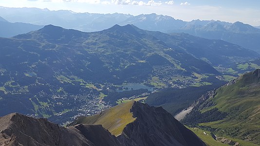
View from the Lenzer Horn to the Lenzerheide .
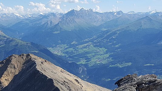
View from Lenzer Horn to Oberhalbstein .

View from Lenzer Horn to Lenz .
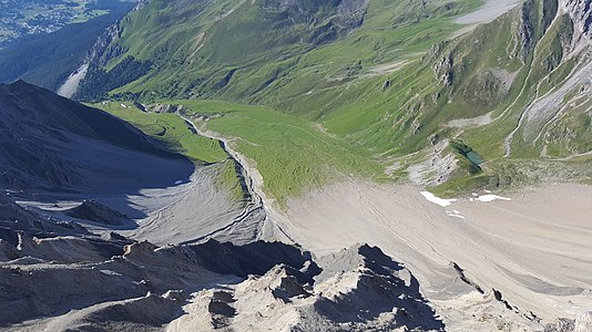
View of the Alp Sanaspans.


literature
- Bernard Condrau, Manfred Hunziker: Club guide, Bündner Alps . Tamina and Plessur Mountains. 4th edition. tape I . Verlag des SAC, 1981, ISBN 3-85902-048-X , p. 318-319 .
- Fabian Lippuner, David Coulin: Alpine hiking / summit destinations, Graubünden North . Verlag des SAC, 2013, ISBN 978-3-85902-341-3 , p. 112-115 .
- Manfred Hunziker : Ringelspitz / Arosa / Rätikon . From the Pass dil Segnas to the Schlappiner Joch. Verlag des SAC, 2010, ISBN 978-3-85902-313-0 , p. 336 ff .
- National map of Switzerland, sheet 1216 Filisur, 1: 25,000, Federal Office of Topography, 2015 edition.
Web links
- 360 ° panorama of the Lenzer Horn
- Tour reports on www.hikr.org
Individual evidence
- ↑ Calculated 360 ° panorama ( U. Deuschle ; notes ) from the Lenzer Horn