
Biberach district
| coat of arms | Germany map |
|---|---|

|

Coordinates: 48 ° 6 ' N , 9 ° 48' E |
| Basic data | |
| State : | Baden-Württemberg |
| Administrative region : | Tübingen |
| Region : | Danube-Iller |
| Administrative headquarters : | Biberach an der Riss |
| Area : | 1,409.74 km 2 |
| Residents: | 199,742 (Dec. 31, 2018) |
| Population density : | 142 inhabitants per km 2 |
| License plate : | BC |
| Circle key : | 08 4 26 |
| NUTS : | DE146 |
| Circle structure: | 45 parishes |
| Address of the district administration: |
Rollinstrasse 9 88400 Biberach |
| Website : | |
| District Administrator : | Heiko Schmid ( independent ) |
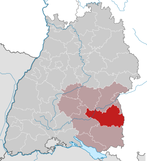
| Location of the district of Biberach in Baden-Württemberg | |
  |
|

The district of Biberach is a district in Baden-Württemberg . Together with the Alb-Danube district and the independent city of Ulm, it forms the Baden-Württemberg part of the Donau-Iller region in the Tübingen administrative district .
geography
location
The district of Biberach is located in Upper Swabia . The western tip still extends to the Swabian Alb . The Iller forms the natural border with Bavaria . The highest elevations in the district are the Rotreiß (801 meters) in the municipality of Langenenslingen and the buses (767 meters) in the municipality of Uttenweiler .
Neighboring areas
The district of Biberach borders clockwise in the north, beginning with the districts of Reutlingen and Alb-Donau-Kreis (both in Baden-Württemberg), the districts of Neu-Ulm and Unterallgäu and the independent city of Memmingen (all in Bavaria ) and the districts Ravensburg and Sigmaringen (both in turn in Baden-Württemberg).
Division of space
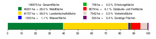
According to data from the State Statistical Office , as of 2015.
history
The district of Biberach goes back to the Württemberg Oberamt of the same name , which was established after the transition of the formerly free imperial city of Biberach and its surrounding area to Württemberg in 1806. Furthermore, the upper offices of Ehingen , Riedlingen , Saulgau , Waldsee , Leutkirch and Zwiefalten had a share in today's district area.
From 1810 the upper offices belonged to the district bailiffs on the Danube or Lake Constance and from 1818 to the Danube district . Most of the upper offices were dissolved in the course of history and merged with neighboring ones. Only the upper offices of Biberach, Leutkirch and Laupheim remained in the 20th century (until 1845 its seat was in Wiblingen ). In 1924 the Danube District was dissolved, and in 1934 the upper offices were renamed to districts.
During the territorial reform of 1938, the districts of Leutkirch and Laupheim were dissolved. Some communities in the Leutkirch district and most of the Laupheim district came to the Biberach district.
During the district reform , the Biberach district received some communities in the Saulgau and Ehingen districts as well as the Billafingen and Langenenslingen districts of the Sigmaringen district on January 1, 1973, and in return gave the Dietmanns community to the Ravensburg district and the communities of Oberbalzheim and Unterbalzheim an der Alb-Donau -Circle from.
On October 1, 1972, the village of Ellighofen was reclassified from Moosbeuren to Attenweiler and thus came from the district of Ehingen to the district of Biberach.
On January 1, 1976, the places Gensenweiler, Hagnaufurt, Hervetsweiler and Wattenweiler were separated from the town of Bad Waldsee, which was part of the Ravensburg district, and incorporated into the municipality of Ingoldingen .
Since the completion of the municipal reform in 1975, the district of Biberach has comprised 45 municipalities, including 6 towns and of these, Biberach an der Riss and Laupheim, two large district towns . The largest city in the district is Biberach an der Riß, the largest community in area is Langenenslingen , and the smallest community is Moosburg.
Population development
The population figures are census results (¹) or official updates from the Baden-Württemberg State Statistical Office ( main residences only ).
|
|
politics
The district is administered by the district council and the district administrator.
District council
The district council is elected for five years by those entitled to vote in the district. The local elections on May 26, 2019 led to the result shown in the diagrams.
- Results of previous district elections
| Parties and constituencies |
% 2019 |
Seats 2019 |
% 2014 |
Seats 2014 |
% 2009 |
Seats 2009 |
% 2004 |
Seats 2004 |
% 1999 |
Seats 1999 |
% 1994 |
Seats 1994 |
% 1989 |
Seats 1989 |
|
| CDU | Christian Democratic Union of Germany | 33.5 | 19th | 42.6 | 25th | 37.4 | 26th | 39.9 | 27 | 43.6 | 25th | 42.4 | 24 | 47.4 | 26th |
| FWV | Free voter association in the Biberach district | 23.5 | 14th | 23.3 | 14th | 25.0 | 17th | - | - | - | - | - | - | - | - |
| GREEN | Alliance 90 / The Greens | 15.2 | 9 | 8.6 | 5 | 8.4 | 4th | - | - | - | - | - | - | 8.7 | 4th |
| WOMEN | Women in the district council | 7.8 | 4th | 6.8 | 4th | 6.1 | 3 | - | - | - | - | - | - | - | - |
| SPD | Social Democratic Party of Germany | 7.1 | 4th | 10.2 | 6th | 12.0 | 5 | 12.6 | 7th | 11.4 | 6th | 14.1 | 7th | 14.1 | 7th |
| ÖDP | Ecologically Democratic Party | 6.2 | 4th | 3.3 | 2 | 3.0 | 1 | - | - | - | - | - | - | - | - |
| FDP | Free Democratic Party | 3.8 | 2 | 3.4 | 2 | 6.1 | 3 | 4.2 | 2 | - | - | - | - | - | - |
| ajp | Active, young, political | 2.0 | 1 | - | - | - | - | - | - | - | - | - | - | - | - |
| PWL | Per western district | 0.9 | - | 1.2 | 1 | - | - | - | - | - | - | - | - | - | - |
| THE LEFT. | THE LEFT. | - | - | 0.5 | 0 | 1.9 | 1 | - | - | - | - | - | - | - | - |
| Flat share | Electoral associations | - | - | - | - | - | - | 40.3 | 23 | 41.3 | 23 | 39.3 | 21st | 25.8 | 14th |
| Otherwise. | Others | - | - | - | - | - | - | - | - | - | - | 0.5 | - | - | - |
| total | 100.0 | 57 | 100.0 | 59 | 100.0 | 60 | 100.0 | 60 | 100.0 | 56 | 100.0 | 54 | 100.0 | 53 | |
| voter turnout | 59.6% | 52.5% | 55.13% | 57.5% | 58.9% | 71.1% | 67.5% | ||||||||
- WG: Voter associations, as the results from 1989 to 2004 cannot be broken down into individual groups of voters.
On July 23, 2008, the district council approved a sponsorship between the district and the Middle Transport Helicopter Regiment 25 “Oberschwaben” in Laupheim.
District Administrator

The district councilor is elected by the district council for a term of eight years. He is the legal representative and representative of the district as well as chairman of the district council and its committees, but has no voting rights in the committees . He heads the district office and is an official of the district.
His area of responsibility includes the preparation of the district council meetings and its committees. He calls meetings, chairs them and implements the resolutions passed there. His deputy is the first state official .
The district councils of the district Biberach since 1937:
- 1937–1945: Maximilian Wizigmann
- 1945–1946: Fritz Erler , SPD
- 1946–1947: Carl Eugen Sprenger
- 1947–1973: Paul Heckmann (1947 initially administrative administrator and 1973 again administrative administrator of the new district of Biberach)
- 1973–1992: Wilfried Steuer , CDU
- 1992–2006: Peter Schneider , CDU
- since 2006: Heiko Schmid
The Oberamtmen of the former Oberamt are shown under Oberamt Biberach .
coat of arms
The coat of arms of the district of Biberach shows a split shield in front in gold a half, red armored black eagle at the crack, in the back a golden abbot with the crook to the left with silver velum. The coat of arms was newly awarded on March 4, 1970 and after the district reform on September 3, 1973.
The imperial eagle stands for the numerous imperial rulers in today's district, especially the formerly free imperial cities of Biberach and Buchau. The abbot stands for the numerous monasteries in the district, some of which were directly imperial and which were secularized in 1803 (Ochsenhausen, Rot an der Rot, Schussenried, Buchau, Heggbach, Heiligkreuztal, Gutenzell).
Economy and Infrastructure
The district holds a share of a good eleven percent in the Oberschwäbische Elektrizitätswerke and, through this stake, also influences the business policy of the energy suppliers EnBW and EGVS . The district's largest employers include Boehringer Ingelheim , Liebherr , Handtmann , Diehl Aviation Laupheim , the district's clinics, Kässbohrer Geländefahrzeug , Südpack , Uhlmann , Rentschler , Silit and Weishaupt .
After the Second World War, the vast majority of the population was still active in agriculture, and structural change in the Biberach district was carried out quickly compared to other districts.
According to a study by the Berlin Institute for Population and Development , the Biberach district is number one in the Federal Republic of Germany when it comes to future viability. With an unemployment rate of 2.5%, the district has one of the lowest in Germany (March 2017). Thus, there is almost full employment in the district, which is why the employment agency is increasingly concentrating on the search for suitable and qualified employees for the regional companies.
traffic

The district is accessed by a total of four railway lines. There is also a museum railway and a railway line that has now been completely closed. In detail these are:
- the Württemberg Southern Railway from Ulm to Friedrichshafen on the Laupheim West - Biberach - Bad Schussenried section
- the Ulm – Sigmaringen railway line , on which only the Riedlingen station is located in the district
- the Leutkirch – Memmingen railway line , on which only the Tannheim (Württemberg) station is located in the district
- the Laupheim West – Schwendi railway line (regular traffic between Laupheim West and Laupheim Stadt, the rest of the line has been dismantled)
- the Öchsle from Warthausen (originally from Biberach) to Ochsenhausen (only museum railway traffic)
- the Federseebahn from Riedlingen to Bad Schussenried (largely dismantled, no more traffic)
The public transport is organized by the Donau-Iller-Nahverkehrsverbund , which also includes the city of Ulm, the Alb-Danube district and the Neu-Ulm district.
The district area is touched by the federal motorway 7 Ulm - Memmingen . It is also accessed by federal, state and district roads. The most important federal highways are the B 30 Ulm - Friedrichshafen, which has four lanes from Biberach to Ulm, the B 312 Reutlingen - Memmingen, the B 311 Donaueschingen - Ulm, which has three lanes all the way through the district, and the B 465 Kirchheim under Teck - Leutkirch im Allgäu .
District facilities
The district of Biberach is responsible for the district high school in Riedlingen , the special education and counseling center with a focus on intellectual development Schwarzbach school with school kindergarten in Biberach and the following vocational schools : District vocational school center Biberach with Gebhard-Müller-Schule (commercial school), Karl-Arnold-Schule (Commercial school) and Matthias Erzberger School (home and agricultural school), Kilian von Steiner School (commercial and commercial school, technical high school) Laupheim and vocational school (commercial, commercial and home economics school) Riedlingen.
Communities
(Residents on December 31, 2018)
Agreed administrative communities and municipal administration associations
|
|
 
|
Municipalities before the district reform
From 1938 onwards, 87 communities , including four towns, belonged to the Biberach district .
On March 7, 1968, the state parliament of Baden-Württemberg set the course for a community reform . With the law to strengthen the administrative power of smaller municipalities , it was possible for smaller municipalities to voluntarily unite to form larger municipalities. The beginning in the district of Biberach made on December 1st, 1971 the municipality of Reinstetten, which united with the city of Ochsenhausen . In the period that followed, the number of communities steadily decreased.
The remaining communities went on January 1, 1973 in the enlarged district of Biberach. Two communities (Oberbalzheim and Unterbalzheim) came to the newly formed Alb-Donau district , where they merged on January 1, 1974 to form the municipality of Balzheim . The Dietmanns municipality came to the Ravensburg district because it was incorporated into the city of Bad Wurzach . Two years later, on January 1, 1975, Unterschwarzach was also incorporated into the town of Bad Wurzach and thus left the Biberach district.
The largest municipality in the old district of Biberach was the district town of Biberach an der Riss , which has been a major district town since February 1, 1962 . The smallest community was Grodt.
The old district of Biberach last covered an area of 1025 km² and had a total of 114,670 inhabitants at the 1970 census. It was the second largest district in Baden-Württemberg after the district of Aalen .
The table shows the population development of the old district of Biberach up to 1970. All population figures are census results.
|
|
In the table, the municipalities of the Biberach district are before the municipal reform. Most of them still belong to the Biberach district today. Only Oberbalzheim and Unterbalzheim belong to the Alb-Danube district and Dietmanns and Unterschwarzach belong to the Ravensburg district .

License Plate
On July 1, 1956, the district was assigned the distinctive sign BC when the license plates that are still valid today were introduced . It is still issued today.
literature
- The district of Biberach. edit from D. Dept. Country Description d. State Archives Sigmaringen. Edited by d. Landesarchivdir. Baden-Württemberg in connection with d. Biberach district, three-volume standard work, 1987
- The state of Baden-Württemberg. Official description by districts and municipalities (in eight volumes); Edited by the Baden-Württemberg State Archives Department; Volume VII: Tübingen District, Stuttgart 1978, ISBN 3-17-004807-4
- Wayside shrines and biotech, churches and cranes. The district of Biberach by Hans-Peter Biege, Dieter Ege, Kurt Diemer, Rolf Dieterich, Achim Zepp, Volker Strohmaier [Ill.]; Jost Einstein, Bernd Holtwick, Siegfried Kullen, Roland Roth, Jürgen Schattmann, Dietmar Schillig, Bernd Schwarzendorfer, Judith Seifert, bvd, 2011
- Literature on the district of Biberach in the catalog of the German National Library
Web links
Individual evidence
- ↑ State Statistical Office Baden-Württemberg - Population by nationality and gender on December 31, 2018 (CSV file) ( help on this ).
- ↑ Survey of land according to type of actual use in 2015
- ↑ a b Federal Statistical Office (ed.): Historical municipality register for the Federal Republic of Germany. Name, border and key number changes in municipalities, counties and administrative districts from May 27, 1970 to December 31, 1982 . W. Kohlhammer, Stuttgart / Mainz 1983, ISBN 3-17-003263-1 , p. 525 f. and 544 ff .
- ^ Result district election 2019 - Lkr.BC (final result) , accessed on September 10, 2019
- ↑ https://www.statistik-bw.de/Wahlen/Kommunal/02043000.tab?R=KR426
- ↑ [1] ( Page no longer available , search in web archives ) Info: The link was automatically marked as defective. Please check the link according to the instructions and then remove this notice. Distribution of votes in the district elections 1989-2009
- ↑ [2] ( Page no longer available , search in web archives ) Info: The link was automatically marked as defective. Please check the link according to the instructions and then remove this notice. Distribution of seats in the district elections 1989-2009
- ↑ http://www.deutsche-handwerks-zeitung.de/beitrag/beitrag_281107.html
- ↑ Regional statistical information. In: statistik.arbeitsagentur.de. Statistics from the Federal Employment Agency, accessed on October 1, 2013 .
- ↑ State Statistical Office Baden-Württemberg - Population by nationality and gender on December 31, 2018 (CSV file) ( help on this ).
Alb-Danube District | Baden-Baden | Biberach | Lake Constance district | Boeblingen | Breisgau-Upper Black Forest | Calw | Emmendingen | Enzkreis | Esslingen | Freiburg im Breisgau | Freudenstadt | Göppingen | Heidelberg | Heidenheim | Heilbronn (Land) | Heilbronn (city) | Hohenlohekreis | Karlsruhe (State) | Karlsruhe (city) | Constance | Loerrach | Ludwigsburg | Main-Tauber district | Mannheim | Neckar-Odenwald district | Ortenaukreis | Ostalbkreis | Pforzheim | Rastatt | Ravensburg | Rems-Murr-Kreis | Reutlingen | Rhein-Neckar District | Rottweil | Schwäbisch Hall | Schwarzwald-Baar district | Sigmaringen | Stuttgart | Tübingen | Tuttlingen | Ulm | Waldshut | Zollernalb district
.svg)
Basking | Backnang | Baden-Baden | Balingen | Biberach | Boeblingen | Bruchsal | Book | Bühl | Calw | Crailsheim | Donaueschingen | Ehingen | Emmendingen | Esslingen | Freiburg (city) | Freiburg (State) | Freudenstadt | Friedrichshafen | Göppingen | Hechingen | Heidelberg (city) | Heidelberg (Country) | Heidenheim | Heilbronn (city) | Heilbronn (Land) | Black Forest | Horb | Karlsruhe (city) | Karlsruhe (State) | Throat | Constance (city) | Constance (Country) | Künzelsau | Lahr | Leonberg | Loerrach | Ludwigsburg | Mannheim (city) | Mannheim (State) | Mergentheim | Mosbach | Muellheim | Münsingen | Neustadt | Nürtingen | Offenburg | Öhringen | Pforzheim (city) | Pforzheim (Country) | Rastatt | Ravensburg | Reutlingen | Rottweil | Säckingen | Saulgau | Schwäbisch Gmünd | Schwäbisch Hall | Sigmaringen | Sinsheim | Stockach | Stuttgart | Tauberbischofsheim | Tettnang | Tübingen | Tuttlingen | Überlingen | Ulm (city) | Ulm (State) | Vaihingen | Villingen | Villingen-Schwenningen | Waiblingen | Waldshut | Cheeks | Wolfach