
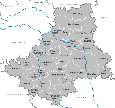
Schwäbisch Hall district
| coat of arms | Germany map |
|---|---|

|

Coordinates: 49 ° 7 ' N , 9 ° 44' E |
| Basic data | |
| State : | Baden-Württemberg |
| Administrative region : | Stuttgart |
| Region : | Heilbronn-Franconia |
| Administrative headquarters : | Schwäbisch Hall |
| Area : | 1,483.97 km 2 |
| Residents: | 195,861 (Dec. 31, 2018) |
| Population density : | 132 inhabitants per km 2 |
| License plate : | SHA, BK , CR |
| Circle key : | 08 1 27 |
| NUTS : | DE11A |
| Circle structure: | 30 parishes |
| Address of the district administration: |
Münzstrasse 1 74523 Schwäbisch Hall |
| Website : | |
| District Administrator : | Gerhard Bauer ( independent ) |
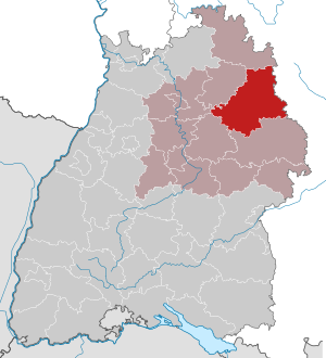
| Location of the district of Schwäbisch Hall in Baden-Württemberg | |
  |
|
The district of Schwäbisch Hall is a district in the Franconian north-east of Baden-Württemberg . It belongs to the Heilbronn-Franken region in the Stuttgart administrative region .
geography
location
The district of Schwäbisch Hall has a share in the Hohenlohe plain , in the heights of the Swabian-Franconian Forest ( Mainhardter Wald , Limpurger Berge , Ellwanger Berge, etc.) and in the Frankenhöhe . The Jagst and the Kocher , the two largest right tributaries of the Neckar , run through the district.
places
The list of places in the district of Schwäbisch Hall includes around 800 places ( towns , villages , hamlets , farms , residential areas and deserted areas ) in the district of Schwäbisch Hall.
Neighboring areas
The district of Schwäbisch Hall borders clockwise in the north, beginning with the districts of Main-Tauber-Kreis (in Baden-Württemberg), Ansbach (in Bavaria ), Ostalbkreis , Rems-Murr-Kreis , Heilbronn and Hohenlohekreis (all in turn in Baden-Württemberg) .
nature
Division of space

According to data from the State Statistical Office , as of 2015.
Nature reserves
According to the protected area statistics of the State Institute for the Environment, Measurements and Nature Conservation Baden-Württemberg (LUBW) , 1,383.29 hectares are under nature protection in the district, which is 0.93 percent of the area. The following nature reserves are designated:
- Maple-linden forest : 7.2 ha; Ruppertshofen district
- Bärenwirtshalde stone blade : 5.2 ha; Markings Sulzbach am Kocher and Laufen am Kocher
- Crailsheimer Eichwald : 6.3 ha; Crailsheim district
- Wet area at the Buchmühle : 4.7 ha; Gemarkungen Rechenberg and Matzenbach
- Gypsum quarry Kirchbühl : 8.4 ha; Gemarkungen Großaltdorf and Unteraspach
- Grimmbach estuary : 8.4 ha; Landmarks Braunsbach and Geislingen am Kocher
- Hammersbachtal northeast of Westgartshausen : 15.4 ha; Westgartshausen district
- Jagsttal with side valleys between Crailsheim and Kirchberg : 492.6 ha; Municipalities Crailsheim , Kirchberg an der Jagst , Satteldorf
- Lime blade : 6.0 ha; Geißelhardt district
- Kochertal between Westheim and Steinbach including Klingenbach and goat and donkey blades : 221 hectares; Districts Schwäbisch Hall , Michelbach an der Bilz , Uttenhofen and Westheim
- Copper moor : 3.7 hectares; District Remaining Hausen
- Oberrimbacher sinkholes : 71.2 ha; Gemarkungen play stream , Oberrimbach and Wildlife Bach
- Heron dump near Bächlingen : 80 ha; Bächlingen district
- Heron dump Morstein : 7.2 ha; District Dünsbach
- Reussenberg : 182.6 ha; Districts Rossfeld , Tiefenbach and Triensbach
- Great Wimbach Gorge : 3.1 ha; District Laufen am Kocher and Frickenhofen
- Lower Bühlertal : 306.0 ha; Districts Untersontheim , Vellberg , Sulzdorf , Unteraspach , Wolpertshausen and Geislingen am Kocher
- Wacholderberg-Geigerswasen : 30.8 ha; Westgartshausen district
history
The district of Schwäbisch Hall goes back to the old Württemberg Oberamt Hall , which was set up as a result of the transition from the former imperial city of Schwäbisch Hall to Württemberg after 1803 and subsequently changed several times. In 1938 it was transferred to the Hall district, which was renamed the Schwäbisch Hall district in 1941.
During the district reform , the district of Schwäbisch Hall was expanded on January 1, 1973 to include almost all the municipalities in the dissolved district of Crailsheim and the Gaildorf area , which had previously been part of the Backnang district . The added district of Crailsheim was also created in 1938 and goes back to the also Württemberg Oberamt Crailsheim ; it was built in 1810 and then changed several times. The area around Gaildorf had its own Oberamt before it was dissolved in 1938 and divided between the districts of Backnang and Schwäbisch Hall.
On January 1, 1972, the two communities Eschental and Goggenbach were reclassified into the district of Öhringen .
On January 1, 1975, the municipality of Stimpfach was taken over from the Ostalb district . It had been reclassified there on January 1, 1973 from the Crailsheim district.
After the community reform was completed in the 1970s, the district of Schwäbisch Hall now includes 30 communities, including nine towns in total and two large district towns (Crailsheim and Schwäbisch Hall). The town of Schwäbisch Hall has the most inhabitants in the district, the town of Langenburg the least ; the non-urban communities lie in between with Mainhardt as the largest and Bühlerzell as the smallest.
Population development
The population figures are census results (¹) or official updates from the Baden-Württemberg State Statistical Office (main residences only).
|
|
politics
The district is administered by the district council and the district administrator. The district council is elected for five years by those entitled to vote in the district. This body elects the district administrator for a term of eight years. This is the legal representative and representative of the district as well as chairman of the district council and its committees. He heads the district office and is an official of the district. His area of responsibility includes the preparation of the district council meetings and its committees. He calls meetings, chairs them and implements the resolutions passed there. He has no voting rights in the committees . His deputy in the management of the district office is the first state official.
District council
The district council is elected for five years by those entitled to vote in the district. The local election on May 25, 2014 resulted in the following distribution of seats:
- Results of the district elections since 1989
| Parties and constituencies | % 2019 |
Seats 2019 |
% 2014 |
Seats 2014 |
% 2009 |
Seats 2009 |
% 2004 |
Seats 2004 |
% 1999 |
Seats 1999 |
% 1994 |
Seats 1994 |
% 1989 |
Seats 1989 |
|
|---|---|---|---|---|---|---|---|---|---|---|---|---|---|---|---|
| FREE | FREE | 27.7 | 17th | 27.16 | 17th | 28.9 | 19th | - | - | - | - | - | - | - | - |
| Flat share | Electoral associations | - | - | - | - | - | - | 29.3 | 20th | 32.7 | 21st | 30.8 | 18th | 30.4 | 16 |
| CDU | Christian Democratic Union of Germany | 23.0 | 12 | 28.50 | 16 | 29.1 | 17th | 33.4 | 20th | 35.4 | 22nd | 33.5 | 20th | 36.5 | 20th |
| SPD | Social Democratic Party of Germany | 12.9 | 8th | 19.58 | 11 | 17.5 | 9 | 16.9 | 9 | 20.4 | 11 | 22.1 | 12 | 24.8 | 12 |
| GREEN | Alliance 90 / The Greens | 16.6 | 10 | 13.01 | 7th | 10.5 | 5 | 9.2 | 5 | 7.5 | 4th | 9.9 | 5 | 8.4 | 4th |
| FDP | Free Democratic Party | 8.5 | 5 | 8.08 | 5 | 10.2 | 6th | 8.3 | 5 | - | - | - | - | - | - |
| ÖDP | Ecological Democratic Party | 3.7 | 2 | 3.67 | 2 | 3.8 | 2 | - | - | - | - | - | - | - | - |
| LEFT | The left | 2.4 | 1 | - | - | - | - | - | - | - | - | - | - | - | - |
| AfD | Alternative for Germany | 5.2 | 3 | - | - | - | - | - | - | - | - | - | - | - | - |
| Otherwise. | Others | - | - | - | - | - | - | 2.9 | 1 | 4.0 | 1 | 3.7 | 2 | - | - |
| total | 100 | 58 | 100 | 58 | 100 | 58 | 100 | 60 | 100 | 59 | 100 | 57 | 100 | 52 | |
| voter turnout | 55.7% | 45.7% | 47.5% | 50.4% | 52.4% | 64.2% | 61.1% | ||||||||
- WG: Voter associations, as the results from 1989 to 2004 cannot be broken down into individual groups of voters.
- The GRÜNE and ÖDP form a parliamentary group in the 2019–2024 election period.
District Administrator
The district administrators of the former Crailsheim district from 1939 to 1972 are shown in the Crailsheim district article .
The Oberamtmen of the Oberamt Hall from 1808 to 1939 are listed in the article Oberamt Hall .
The district councils of the district Schwäbisch Hall since 1939:
- 1939–1945: Wilhelm Winghofer ( clerk )
- 1945: Eduard Hirsch (administrator)
- 1945–1949: Erich Dietz
- 1949–1960: Hermann Müller
- 1960–1987: Roland Biser
- 1988–2003: Ulrich Stückle
- since 2004: Gerhard Bauer
coat of arms
In silver, diagonally crossed, growing out of a shield base quartered with silver and black, a black kettle hook (Kräuel) and a black raftsman's hook; in between there is a red disk with a silver cross inside (coat of arms awarded April 25, 1974).

The fourth Zollern coat of arms stands for the former Margraviate of Brandenburg-Ansbach , which owned a large area in the former Crailsheim district. The kettle hook is the coat of arms of the city of Crailsheim . The raftsman's hook comes from the coat of arms of the Counts of Limpurg , who had a share in the southern district area. The disk represents the "Heller coin". The city of Schwäbisch Hall has been a mint and birthplace of the Heller named after it since the Staufer period.
Before the district reform, the old district of Schwäbisch Hall had a different coat of arms. It showed in gold on a red three-mountain a striding sowing farmer with a blue, red-lined skirt, black breeches, shoes and a hat, silver stockings and a silver sack bag. The former Oberamt Hall had adopted this coat of arms on November 29, 1928 by the district council. This coat of arms was intended to symbolize the agricultural region and the Franconian costume . Black and gold refer to the colors of Württemberg, gold and red to the city colors of the district town.
See also: List of coats of arms in the district of Schwäbisch Hall
District partnerships
The district of Schwäbisch Hall maintains partnership relationships with the district of North Saxony (until 2008, the district of Delitzsch ) in Saxony and the district of Zamość in Poland .
Economy and Infrastructure
In the Future Atlas 2016 , the district of Schwäbisch Hall was ranked 91st out of 402 districts, municipal associations and independent cities in Germany, making it one of the places with "future opportunities".
Agriculture
The district is home to the domestic pig breed Schwäbisch-Hällisches Landschwein , from which quality pork from a protected geographical origin is obtained.
traffic

In 1862 the Royal Württemberg State Railways first put the "Kocherbahn" from Heilbronn to Schwäbisch Hall into operation, which was continued in 1867 to Crailsheim, which had been reached the year before by the Obere Jagstbahn from Aalen . From 1869, the line to Königshofen began at the Crailsheim junction station ; In 1875 the connection to Nuremberg followed . Another connection to Stuttgart brought the Murrtalbahn , which branched off in Hessental near Schwäbisch Hall to Gaildorf and on to Backnang in 1879/80 .
It was not until 1900 that the small residential town of Langenburg was linked from Blaufelden to the Crailsheim – Königshofen railway via a branch line. Since 1903 the Württembergische Eisenbahn-Gesellschaft has been running its Obere Kochertalbahn from Gaildorf West train station up to Untergröningen for a part in the Kochertal . It was closed for passenger traffic in 2000. It has been resting on the route between Blaufelden and Langenburg since 1963. The network of the main railways is still 112 km long.
The A 6 Heilbronn – Nürnberg runs through the southern district, while in the extreme southeast the A 7 Ulm - Würzburg briefly touches the district near Fichtenau . Furthermore, several federal, state and district roads open up the district. Important federal roads are the B 14 Schwäbisch Hall – Stuttgart, the B 19 Schwäbisch Hall – Würzburg and the B 290 Aalen – Bad Mergentheim.
District facilities
The Schwäbisch Hall district is responsible for the following vocational schools : Schwäbisch Hall commercial school, Schwäbisch Hall commercial school, Sibilla Egen school (home economics school) Schwäbisch Hall, Crailsheim commercial school, Crailsheim commercial school and Eugen Grimminger school (home economics and agricultural school ) Crailsheim also has the following special education and counseling centers : Froebel School with Kindergarten in Satteldorf (focus on intellectual development), Wolfgang Wendlandt School Schwäbisch Hall (focus on language) and Crailsheim Language School (focus on language).
The Schwäbisch Hall district is responsible for the Crailsheim Clinic.
Communities
(Residents on December 31, 2018)
  Agreed administrative communities and municipal administration associations
|
|
Municipalities before the district reform
Before the district reform on January 1, 1973 or before the community reform , the (old) district of Schwäbisch Hall had a total of 46 communities since 1938 , including 3 towns .
On March 7, 1968, the state parliament of Baden-Württemberg set the course for a community reform . With the law to strengthen the administrative power of smaller municipalities , it was possible for smaller municipalities to voluntarily unite to form larger municipalities. The beginning in the old district of Schwäbisch Hall was made on July 1, 1971 by the Gnadental community, which merged with the Michelfeld community . In the period that followed, the number of communities steadily decreased. On January 1, 1972, the communities Eschental and Goggenbach left the district of Schwäbisch Hall, because they were incorporated into the community of Kupferzell , district of Öhringen . The remaining communities in the old district of Schwäbisch Hall were merged into the new, enlarged district of Schwäbisch Hall on January 1, 1973 , but on January 1, 1974, the municipality of Finsterrot, which had been part of the old district until 1972, was transferred to the Heilbronn district because this community united with Wüstenrot .
The largest municipality in the old district of Schwäbisch Hall was the district town of Schwäbisch Hall, which has been a major district town since October 1, 1960. The smallest community was Goggenbach.
The old district of Schwäbisch Hall last covered an area of 568 km² and had a total of 63,864 inhabitants at the 1970 census .
The table shows the population development in the old district of Schwäbisch Hall up to 1970. All population figures are census results.
|
|
In the table, the municipalities of the old district of Schwäbisch Hall are before the municipal reform. Except for the three communities Eschental, Goggenbach and Finsterrot, all of them still belong to the Schwäbisch Hall district today. Eschental and Goggenbach now belong to the Hohenlohe district, Finsterrot to the Heilbronn district.

License Plate
On July 1, 1956, the district was assigned the distinctive SHA sign when the vehicle registration number that is still valid today was introduced . It is still issued today. Until the 1990s, vehicles from the old Crailsheim district received license plates with the letter pairs PA to ZZ and the numbers from 1 to 999.
Since March 28, 2014, due to the license plate liberalization, the CR ( Crailsheim ) distinguishing mark and the BK ( Backnang ) since September 1, 2018 .
literature
- The district of Schwäbisch Hall . Edited by the Baden-Württemberg State Archive in conjunction with the Schwäbisch Hall district. Thorbecke, Ostfildern 2005 (Baden-Württemberg - The state in its circles), ISBN 3-7995-1366-3 .
- The state of Baden-Wuerttemberg - official description according to districts and municipalities (in eight volumes); Edited by the Baden-Württemberg State Archives Department; Volume IV: Stuttgart District - Regional Associations Franconia and East Wuerttemberg, Stuttgart 1980, ISBN 3-17-005708-1 .
- The nature reserves in the Stuttgart administrative region . Edited by Reinhard Wolf . Jan Thorbecke Verlag, Stuttgart 2002. ISBN 3-7995-5173-5 .
Web links
- Official website of the district
- State Statistical Office Baden-Württemberg - Structural and regional database
- Literature from and about the district of Schwäbisch Hall in the catalog of the German National Library
Individual evidence
- ↑ a b Statistisches Landesamt Baden-Württemberg - Population by nationality and gender on December 31, 2018 (CSV file) ( help on this ).
- ↑ Survey of land according to type of actual use in 2015
- ↑ LUBW protected area statistics ( Memento from January 20, 2015 in the Internet Archive )
- ↑ a b Federal Statistical Office (ed.): Historical municipality register for the Federal Republic of Germany. Name, border and key number changes in municipalities, counties and administrative districts from May 27, 1970 to December 31, 1982 . W. Kohlhammer, Stuttgart / Mainz 1983, ISBN 3-17-003263-1 , p. 456 f. and 467 f .
- ↑ Baden-Württemberg State Statistical Office, preliminary results of the 2019 district council elections , accessed on September 9, 2019
- ↑ District elections 2014
- ↑ [1] ( Page no longer available , search in web archives ) Info: The link was automatically marked as defective. Please check the link according to the instructions and then remove this notice. Distribution of seats in the district elections 1989-2009
- ↑ Future Atlas 2016. Archived from the original on October 2, 2017 ; accessed on March 23, 2018 . Info: The archive link was inserted automatically and has not yet been checked. Please check the original and archive link according to the instructions and then remove this notice.
Alb-Danube District | Baden-Baden | Biberach | Lake Constance district | Boeblingen | Breisgau-Upper Black Forest | Calw | Emmendingen | Enzkreis | Esslingen | Freiburg im Breisgau | Freudenstadt | Göppingen | Heidelberg | Heidenheim | Heilbronn (Land) | Heilbronn (city) | Hohenlohekreis | Karlsruhe (State) | Karlsruhe (city) | Constance | Loerrach | Ludwigsburg | Main-Tauber district | Mannheim | Neckar-Odenwald district | Ortenaukreis | Ostalbkreis | Pforzheim | Rastatt | Ravensburg | Rems-Murr-Kreis | Reutlingen | Rhein-Neckar District | Rottweil | Schwäbisch Hall | Schwarzwald-Baar district | Sigmaringen | Stuttgart | Tübingen | Tuttlingen | Ulm | Waldshut | Zollernalb district
.svg)
Basking | Backnang | Baden-Baden | Balingen | Biberach | Boeblingen | Bruchsal | Book | Bühl | Calw | Crailsheim | Donaueschingen | Ehingen | Emmendingen | Esslingen | Freiburg (city) | Freiburg (State) | Freudenstadt | Friedrichshafen | Göppingen | Hechingen | Heidelberg (city) | Heidelberg (Country) | Heidenheim | Heilbronn (city) | Heilbronn (Land) | Black Forest | Horb | Karlsruhe (city) | Karlsruhe (State) | Throat | Constance (city) | Constance (Country) | Künzelsau | Lahr | Leonberg | Loerrach | Ludwigsburg | Mannheim (city) | Mannheim (State) | Mergentheim | Mosbach | Muellheim | Münsingen | Neustadt | Nürtingen | Offenburg | Öhringen | Pforzheim (city) | Pforzheim (Country) | Rastatt | Ravensburg | Reutlingen | Rottweil | Säckingen | Saulgau | Schwäbisch Gmünd | Schwäbisch Hall | Sigmaringen | Sinsheim | Stockach | Stuttgart | Tauberbischofsheim | Tettnang | Tübingen | Tuttlingen | Überlingen | Ulm (city) | Ulm (State) | Vaihingen | Villingen | Villingen-Schwenningen | Waiblingen | Waldshut | Cheeks | Wolfach