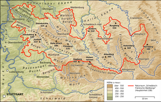
Ellwanger Mountains
| Ellwanger Mountains | |
|---|---|
|
The Ellwanger mountains in the eastern part of the |
|
| Highest peak | Schönberg ( 569.2 m above sea level ) |
| location | District of Schwäbisch Hall , Ostalbkreis in Baden-Württemberg (Germany) |
| Coordinates | 48 ° 58 ′ N , 10 ° 2 ′ E |
| rock | Keuper |
The Ellwanger Mountains are one to 569.2 m above sea level. NHN high ridge in the district of Schwäbisch Hall and in the Ostalb district in Baden-Württemberg ( Germany ).
The name of the Ellwanger Mountains is derived from the town of Ellwangen . The Ellwang Mountains became known nationwide primarily for the motorway service station of the same name on the federal motorway 7 .
geography
location
The existing Ellwang Mountains, which belong to the Keuperbergland , are located about 65 km northeast of Stuttgart and about 67 km (as the crow flies ) east-southeast of Heilbronn between the Haller level in the north, the Frankenhöhe and the Virngrund in the east, the Härtsfeld in the south and the Frickenhofer Höhe in the southwest and the Limpurger Mountains in the west. They are located south of Frankenhardt , west of Rosenberg and Ellwangen , northwest of Hüttlingen , east of Adelmannsfelden , Bühlerzell and Bühlertann and southeast of Obersontheim and Vellberg .
mountains
The highest mountain in the Ellwang Mountains is the Schönberg at 569.2 m , 1.7 km north-northeast of Neuler- Gaishardt . To the south of the summit, it has a somewhat restless plateau about 100 m wide, but about 700 m towards the south, above 560 m height, is entirely forested and therefore does not allow a view.
It is followed by the Hohenberg at a height of 568.9 m , at whose eastern foot the village of Rosenberg- Hohenberg lies. The mountain is a steep hilltop, about 50 m above its surroundings, with a 300 m long (west-east) and 100 m wide high plateau. Except for the western slope, the entire hilltop is unwooded and offers a view over a large part of the Ellwang Mountains, in the south up to the Albtrauf . Several hiking trails meet on the hilltop, from the Burgberg in the north, Bühlerzell in the west, from Orrotsee in the east, from Ellwangen in the southeast. On top of it stands the Jakobuskirche, a pilgrimage church; a way of the cross runs up the path from the village . A Way of St. James has been passing here for a number of years, reaching the church from Rothenburg ob der Tauber via the Burgberg and then continuing via Abtsgmünd - Wöllstein towards Switzerland.
About 2 km south or south-east of the aforementioned Schönberg, separated from the Frankenbach, are two extensive, very flat Jura plateaus that plunge slightly to the south-east and steeply sloping towards the surrounding valleys, which are over 540 m high at their highest points . The south-eastern one surrounds the Schrezheimer hamlet Hinterlengenberg (town of Ellwangen), the southern, larger one the hamlet of Leinenfirst (municipality of Neuler ). Most of the land is used intensively for agriculture.
A striking western spur of the mountains near Bühlertann , on which the Tannenburg stands, rises far above the bounding Bühlertal .
Waters
Rivers of the Ellwang Mountains are the Bühler , which rises south of the forest landscape, passes it to the west and flows via Bühlertann to Vellberg and flows further north into the Kocher , and the Blinde Rot , which rises in the northern part of the Ellwanger Mountains, flows south via Adelmannsfelden and flows into the Kocher a few kilometers further south. The Jagst runs slightly to the east of the forest landscape and runs mainly to the northwest and flows into the Neckar at Bad Friedrichshall - Jagstfeld .
The Treibsee east of Bühlerzell - Kammerstatt belongs to the still waters .
geology
The Ellwanger Mountains consist of Keuper . The Stubensandstein has a thickness of over 100 meters in the area of the Ellwanger Mountains and thus dominates the range of mountains. In the north , the layers alternate quickly towards the Hohenlohe Plain : Upper colored marl , silica sandstone , lower colored marl , reed sandstone and gypsum keuper ( grave field formation ). In the south, towards the foothills of the Alb, the tuber marl covers the parlor sandstone with significantly less thickness and above it already covers the lowest layers of the Lower Jurassic .
flora
The Ellwang Mountains also show typical low mountain range character in their flora. Large areas are covered by forest. The most important tree species is the spruce . However, the silver fir also thrives on the water-containing soils. Originally it was the predominant tree species next to the beech. Spruce cultures were only created in the course of intensive forestry use.
The flora largely reflects the geological conditions. The acidic soils of the Stubensandstein are home to plants with corresponding demands: The blueberry ( Vaccinium myrtillus ) can mainly be found in the coniferous forests over almost the entire mountain range. The Ellwang Mountains, together with the Limpurger Mountains , Mainhardter Forest , Virngrund and the immediately adjacent regions, form a focus of the distribution of the sprouting bear moss ( Lycopodium annotinum ) in Baden-Württemberg. Only a few occurrences of the common flat bear moss ( Diphasiastrum complanatum ) were known and there has been no evidence for a long time. From Leafless cons Bart ( Epipogium aphyllum ), a rather atypical for the Stubensandstein plant, only one site was known; he has not been observed there since the 1980s.

