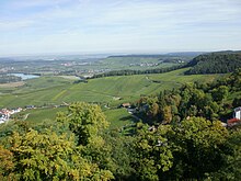
Keuperbergland
The Keuperbergland (more rarely Keuperwaldberge ) is part of the southern German layered landscape and covers an area of around 3200 square kilometers .

From southwest to northeast, the Keuper Hills include Kleiner Heuberg , Rammert , Schönbuch , Glemswald , Strom- and Heuchelberg , Schurwald and Welzheimer Wald , Swabian-Franconian Forest Mountains , Frankenhöhe , Steigerwald and Hassberge . The most south-westerly Keuperschicht stage in the Baar area has no name of its own due to its small size.
Natural structure

The Keuperbergland is divided into three natural spatial main unit groups and the three-digit main units listed below (units that are only to a small extent on Keuper are in italics) as well as, subordinate, the following orographically separated mountain ranges (depressions and edge heights left out):
-
(to the south-west German layer level country )
-
(for 12 Neckar and Tauber-Gäuplatten )
- 124 Stromberg and Heuchelberg
- 124.1 Stromberg
- 124.2 Heuchelberg and Eppinger Hardt
- 124 Stromberg and Heuchelberg
- to 10 Swabian Keuper-Lias-Land
- 104 Schönbuch and Glemswald
- 107 Schurwald and Welzheimer Wald
- 107.0 Virgin Forest
- 107.2 Berglen
- 107.3 Welzheim Forest
- 108 Swabian-Franconian forest mountains
- 108.00 Murrhardt Forest
- 108.11 Sulmer Bergebene
- 108.13 / 14 Löwenstein Mountains (in the narrower sense)
- 108.30 Kirnberg Forest
- 108.31 Sulzbach Forest
- 108.4 Mainhardt Forest
- 108.5 Waldenburg Mountains
- 108.60 Limpurger Mountains
- 108.70 Ellwanger Mountains
- (to 11 Franconian Keuper-Lias-Land )
- 114 Swiss francs
- 115 Steigerwald
- 116 Hate Mountains
-
(to 117 Itz-Baunach-Hügelland )
- 117.40 Zeilberge
-
(for 12 Neckar and Tauber-Gäuplatten )
Except for electricity and Heuchelberg , the north of the Schönenbuch and Glemswald -Lia landscapes keuper and outside of the shell heavy lie Gäuen, the scenery in the list above along the Albtrauf from which it by liaslastige separated Vorländer, arranged in the direction of the northeast .
landscape
The eponymous Keuper , the highest and youngest lithostratigraphic group of the Germanic Triassic, is decisive for the landscape . It shows a changing variety of deposits of sand and sea deposits.
Most of the Keuperbergland is forested, as the soil on Keuper is not very fertile. Clearing islands are mainly found on the fertile loess or lias soils.
The very steep notch valleys typical of the Keuperbergland are referred to here as " blades ". Such blades appear in the petrographically harder sandstone layers of the Keuper, for example in the parlor sandstone . These rocks can offer sufficient resistance to the erosion forces (above all side erosion) of the water. In the less erosion-resistant rocks of the Keuper such as clays or marls , on the other hand, the valley is more pronounced, so that there are much wider shapes.
Individual evidence
-
↑ Various authors: Geographische Landesaufnahme: The natural spatial units in single sheets 1: 200,000 . Federal Institute for Regional Studies, Bad Godesberg 1952–1994. → Online maps
- Sheet 153: Bamberg (Karl Albert Habbe 2004, in Mitteilungen der Fränkische Geographische Gesellschaft 2003/2004 , pp. 55-102; 48 pp.)
- Sheet 161: Karlsruhe ( Josef Schmithüsen 1952; 24 pages)
- Sheet 162: Rotenburg od Tauber ( Wolf-Dieter Sick 1962; 58 p.)
- Sheet 163: Nuremberg ( Franz Tichy 1973; 33 pages)
- Sheet 170: Stuttgart ( Friedrich Huttenlocher , Hansjörg Dongus 1967; 76 pages)
- Sheet 171: Göppingen (Hansjörg Dongus 1961; 54 p.)
- Sheet 172: Nördlingen (Ralph Jätzold 1962; 39 pages)
Web links
- Tobias Columnberger, Geoecology of the Keuperbergland (PDF file; 2.13 MB)
- Kerf, Kies and Letten - the Keuperland - geology and vineyard soils of Württemberg, part 3. Ministry of Food and Rural Areas Baden-Württemberg (MLR)