Murrhardt Forest
| Murrhardt Forest | |
|---|---|
|
The murrhardt forest in the southwest of the |
|
| Highest peak | Hohenstein ( 572.7 m above sea level ) |
| part of | Swabian-Franconian Forest |
| Coordinates | 48 ° 58 ′ N , 9 ° 30 ′ E |
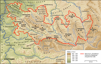
The Murrhardt Forest in the Rems-Murr district in Baden-Württemberg is a sub-area of the natural spatial main unit of the Swabian-Franconian Forest Mountains . It is a maximum of 572.7 m above sea level. NHN high. It takes its name from the city of Murrhardt in its center.
geography
location
The Murrhardter Wald is around 35 km (as the crow flies ) northeast of Stuttgart and almost as far southeast of Heilbronn , between the Mainhardter Wald in the northeast and east, the Welzheimer Wald in the south, the Backnang Bay in the west and the Löwenstein Mountains in the northwest.
The low mountain range forest lies on both sides of the axis of the Murr valley with a little overweight to the left of the river. The area is bordered by the towns of Oberrot in the northeast, Fichtenberg in the east, Kaisersbach in the southeast, Althütte and Auenwald in the south, Backnang in the southwest, Oppenweiler in the west and Sulzbach an der Murr in the northwest.
The Murrhardt Forest is drained by the Murr, which rises here and runs through it westwards after a prominent bend and then flows further west into the Neckar . The larger streams Otterbach and Fornsbach run towards the Murr at its upper course bend , in Murrhardt Trauzenbach and Hörschbach , on its further west course then Harbach , Eschelbach and Haselbach . Like numerous smaller streams, they flow largely in wooded blades and occasionally tumble over rocky banks, such as the Hörschbach at its two high waterfalls.
The largest lake in the Murrhardt Forest, with 2 hectares of water surface, is the "Waldsee", which is open to tourists, near the Murrhardt district of Fornsbach .
mountains
The mountains and elevations as well as their foothills in the Murrhardt Forest include - sorted by height in meters (m) above sea level (NHN):
- Hohenstein ( 572.7 m ), 0.8 km south-southeast of Sechselberg in the municipality of Althütte
- Folding rule ( 544.1 m ), with the southern slope Wüstenberg , 0.8 km southwest of the Eschelhof in the municipality of Sulzbach an der Murr
- Hoblersberg ( 539.9 m ), 1.1 km south-southeast of Murrhardt-Waltersberg
- Springstein ( 532.8 m ), 0.9 km southwest of Murrhardt-Siebenknie
- Hornberg ( 490.4 m ), 0.5 km west-northwest of Fichtenberg- Hornberg
- Linderst (name of the southern slope) ( 460.4 m ), 0.8 km north-northwest of the Murrhardter Almsiedlung
- Raitberg ( 447.3 m ), 1 km east of Murrhardt-Köchersberg
Nature and landscape protection, tourism
Large areas of the Murrhardt Forest are designated as landscape protection areas , smaller areas as nature protection areas. Almost all of it lies in the Swabian-Franconian Forest Nature Park .
The Murrhardter Wald is a popular hiking area. The Limes hiking trail of the Swabian Alb Association (HW 6) closely follows the route of the Upper German-Raetian Limes . The Georg-Fahrbach-Weg of the Swabian Alb Association also crosses the Murrhardt Forest. A fairy tale hiking trail runs along the Hörschbach. For cyclists, the Idyllische Strasse cycle path and the German Limes cycle path cross the forest area. In a north-south direction, the tourist roads Deutsche Limes-Straße and Idyllische Straße lead through the low mountain forest.
South of Murrhardt, on the slope of the Riesberg (also called Rißberg ), the wooden Riesberg tower stands on a north-east spur . Its platform offers a view of Murrhardt in its valley spider and into the side valleys.
Individual evidence
- ↑ a b Map services of the Federal Agency for Nature Conservation ( information )
- ↑ a b Geoportal Baden-Württemberg ( information ) on a scale of 1: 10,000. A lower value of 569.3 m on some maps is not at the highest point, but at a fork in the road.
literature
- Hiking map Schwäbisch Hall - Backnang , M = 1: 35,000, publisher Schwäbischer Albverein , sheet 8, ISBN 978-3-920801-75-9
