
Swabian-Franconian Forest Nature Park

The Swabian-Franconian Forest Nature Park in north-eastern Baden-Württemberg , founded in 1979, comprises large parts of the neighboring natural areas of the Swabian-Franconian Forest Mountains as well as the Schurwald and Welzheimer Wald . In addition, at its borders it has a share in the natural areas of Hohenloher and Haller Plains , Eastern Alb foreland and Neckar Basin . The extent of the nature park is roughly described by the cities of Backnang , Beilstein , Weinsberg , Öhringen , Schwäbisch Hall , Gaildorf , Lorch and Schorndorf .
The nature park comprises parts of the districts of Rems-Murr-Kreis (share of the total area of the nature park: 47%), Schwäbisch Hall (22%), Heilbronn (11%), Hohenlohekreis (10%), Ostalbkreis (9%) and Ludwigsburg ( 1 %).
The Schwäbisch-Franconian Forest Nature Park Association, which was also founded in 1979, includes the six districts, 37 cities and municipalities as well as associations from agriculture, forestry and nature conservation. From 1979 to 2006, more than 15 million euros were invested in recreational facilities, landscape maintenance , environmental education , public relations and the preservation of cultural heritage. The office and a permanent exhibition are located in the nature park center in the city of Murrhardt , which opened on June 22nd, 2004 .
The nature park has a total area of about 900 km² and is located in a mainly mountainous landscape at a height of 200 m in the Sulmtal to 587 m in the Mainhardt Forest ( Hohe Brach ). The climate ranges from a mild wine-growing climate (annual average temperature 9 ° C and 800 mm of precipitation) in the Sulmtal to a cool, humid, stimulating climate at high altitudes (7.5 ° C at 1100 mm). 53% of its area is covered by forest .
The nature park consists of five sub-regions: the Murrhardter and Mainhardter Wald as well as the Waldenburger and Löwensteiner Mountains in the Swabian-Franconian Forest Mountains and the Welzheimer Forest , which is assigned to the Schurwald and Welzheimer Forest natural areas . At its eastern edge the Frickenhofer Höhe is also touched, which in this area is part of the eastern Alb foreland natural area .
The Murr , its tributary “Spiegelberger” Lauter , Sulm , Ohrn , Lein and some tributaries of the Rems such as the Wieslauf have their source in the nature park . The Ebnisee on its upper course was created as a reservoir for the rafting. Today, like many other lakes in the nature park, it is approved as a bathing lake. The Hörschbach , a southern tributary of the Murr, falls over waterfalls at two points in its course.
The UNESCO - World Heritage Limes Germanicus , one in the second century against the Celts and Germanic -scale border fortification of the Roman Empire , runs through the nature park almost straight north-south direction from Öhringen to Lorch. The Romans built forts in these two places as well as in Mainhardt , Murrhardt and Welzheim . Traces of the border system can still be seen in many places today, and an almost one kilometer long visible Limes section with a hexagonal watchtower foundation at Pfedelbach - Gleichen deserves special mention (from north to south) , and another longer Limes section between the valley of the Rot and Großerlach - Grave as well as east of the Ebnisees (both with watchtower foundation), in addition still at Welzheim the preserved remains of the small fort Rötelsee and the Welzheimer Ostkastell. At Mainhardt- Gailsbach , Großerlach-Grab and Lorch, watchtower reconstructions were made, of which only the tower at Grab, as a stone tower, comes close to the historical model. Excavation finds are exhibited in greater numbers in Öhringen ( Weygang Museum ), Mainhardt (Roman Museum), Murrhardt (Carl-Schweizer-Museum) and Welzheim (Heimatmuseum).
The history of glass production from the 15th to 19th centuries is presented in the Spiegelberg Glass Museum . In the visitors' mine Wetzsteinstollen near Spiegelberg-Jux, whetstones were mined underground until 1920.
The visitors of the nature park are several hiking trails to flora, fauna, geology, viticulture and history to choose from, including some of the Limes hiking route (HW 6) of the Swabian Alp Association between Lorch and Öhringen and the Mühlenwanderweg in Welzheim and Kaisersbach . Since 2007, there have been nature park markets spread over the year in various places in the nature park , where regional products from the Swabian-Franconian forest are sold; a supporting program presents various aspects of the nature park.

Fallow deer enclosure in Pfedelbach -leichen
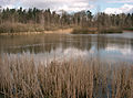
The new Gleichener See in the Mainhardt Forest

The route of the Limes in Pfedelbach-Gleichen can be seen in the area

Foundation of the hexagonal tower (WP 51) in Gleichen


literature
- Werner Sippel: Schwäbisch-Franconian Forest Nature Park , hiking guide, 50 round trips, 1st edition March 2015, KOMPASS-Verlag Innsbruck, ISBN 978-3-99044-038-4 .
- Dietwulf Baatz : The Roman Limes. Archaeological excursions between the Rhine and the Danube. 4th, completely revised and enlarged edition. Gebrüder Mann, Berlin 2000, ISBN 3-7861-2347-0 .
- Paul Strähle: Swabian-Franconian Forest Nature Park . Revised by Theo Müller . 4th, revised and expanded edition. Theiss, Stuttgart 2006, ISBN 3-8062-2033-6 .
- Dieter Buck: excursion destination Swabian-Franconian Forest. Silberburg-Verlag , Tübingen 2005, ISBN 3-87407-648-2 .
- Renate Florl: Out and about with children: Swabian-Franconian Forest. Fleischhauer & Spohn Verlag, Bietigheim-Bissingen, ISBN 978-3-87230-601-2 .
- Renate Florl: Hiking with the pram - in the Swabian-Franconian Forest. 30 tours suitable for babies. Fleischhauer & Spohn Verlag, Tübingen, ISBN 978-3-87407-876-4 .
- Claudia Gollor-Knüdeler: The Swabian-Franconian Forest. Text by Bernhard Drixler. German English French. Silberburg-Verlag , Tübingen, ISBN 3-87407-535-4 .
Web links
Coordinates: 48 ° 58 ′ 46.1 ″ N , 9 ° 34 ′ 45.2 ″ E