
Großerlach
| coat of arms | Germany map | |
|---|---|---|

|
Coordinates: 49 ° 3 ' N , 9 ° 31' E |
|
| Basic data | ||
| State : | Baden-Württemberg | |
| Administrative region : | Stuttgart | |
| County : | Rems-Murr district | |
| Height : | 522 m above sea level NHN | |
| Area : | 27.14 km 2 | |
| Residents: | 2437 (December 31, 2018) | |
| Population density : | 90 inhabitants per km 2 | |
| Postcodes : | 71577, 71560 | |
| Primaries : | 07903, 07192, 07193 | |
| License plate : | WN, BK | |
| Community key : | 08 1 19 024 | |
| Address of the municipal administration: |
Stuttgarter Strasse 18 71577 Großerlach |
|
| Website : | ||
| Mayor : | Christoph Jäger | |
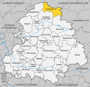
| Location of the community Großerlach in the Rems-Murr district | ||
  |
||

Großerlach [ ɡroːsˈʔɛrlax ] is a rural municipality in the Rems-Murr district , Baden-Württemberg . With around 2600 inhabitants and a population density of less than 100 inhabitants per km², it is one of the most sparsely populated communities in the Stuttgart region .
geography
Geographical location
The municipality of Großerlach is located in the Mainhardt Forest on the plateau between Rot in the north and Murr in the south. The Hohen Brach is the highest point in the natural area of the Swabian-Franconian Forest Mountains and the Rems-Murr district in the municipality.
Neighboring communities are Wüstenrot ( district of Heilbronn ) in the northwest, Mainhardt in the north, Oberrot in the east (both districts of Schwäbisch Hall ), Murrhardt and Sulzbach an der Murr in the south and Spiegelberg in the west.
Community structure
The municipality of Großerlach includes 25 scattered villages, hamlets, farms and houses (the population figures in brackets).
The villages of Großerlach (742) and Neufürstenhütte (489), the hamlets of Altfürstenhütte (108), Böhringsweiler (20), Hals (33), Kleinerlach (37), Kuhnweiler (7) belong to the area of the municipality of Großerlach before the regional reform of the 1970s. , Liemersbach (144), Mittelfischbach (24), Oberfischbach (37), Unterfischbach (13), the Wiedhof homestead (16) and the Erlach residential area (164).
The area of the former municipality of Grab includes the village of Grab (389), the hamlets of Frankenweiler (22), Hohenbrach (35), Mannenweiler (17), Morbach (78), Schönbronn (66), Schöntalhöfle (also Schertelhöfle) (27) and Trauzenbach (47) and the residential areas Butzberg (6), Platte (11), Schöntalsägmühle (3) and Schweizerhof (9). Between Großerlach and Mainhardt of 1,891 spent and is Outbound living space Gollenhof.
The former municipality of grave forms a town within the meaning of Baden-Württemberg municipal code with its own six members existing Ortschaftsrat .

Division of space

According to data from the State Statistical Office , as of 2014.
history
Böhringsweiler is first documented in 1251. Trauzenbach is mentioned for the first time on May 24th, 1300. In 1364 and 1370 the two Erlach farms belonged to Rüdiger von Ohrn on the one hand and to the Burkhard and Friedrich Sturmfeder brothers on the other . Around 1500 the first farm (Amt Sulzbach) is owned by the Count von Löwenstein and the Schenk von Limpurg is the landlord of the second farm (Amt Oberrot). Großerlach was first mentioned on January 2, 1441, when it was sold by the Counts of Löwenstein to Count Palatine Ludwig IV . Gross-Oehrlach, Ober-Oehrlach and Klein-Oehrlach, Unter-Oehrlach and Glashütte are already mentioned in 1750. The sole landlord is now the Count of Löwenstein. Both the territory of the Limpurg gift shop and the territory of the Count of Löwenstein belonged to the Franconian Empire from 1500 to 1806 .
In 1911 water pipes and the first telephone lines are built, followed by connection to the power grid in 1927. Towards the end of the Second World War , on April 16, 1945, the Wehrmacht blew up the bridge from Großerlach to Mainhardt. Two days later, on April 18, American soldiers occupied the place with their tanks.
Glassworks

In 1568 Hans Greiner, the son of the master smelter von Neulautern , founded the first forest glassworks in Mittelfischbach, which was operated until 1702. In 1605 glass was produced in Altfürstenhütte and in 1695 in Neufürstenhütte, which was discontinued in 1771.
In 1737 the last glassworks went into operation in the Erlach district , today's Erlacher Höhe. In 1781, Israel Oechsle from the Black Forest was hired as Hüttmeister. He has the necessary knowledge to produce high-quality clear glass instead of the previously greenish forest glass. His son Ferdinand Oechsle later invents the Oechsle balance . Pharmacy products such as flasks and stills are mainly produced in Erlach. In 1891 the Diakonisches Werk acquires the Erlacher Glashütte and founds the Erlach workers' colony (today: Erlacher Höhe ), which is today the first bioenergy village in the district and nationwide within the Diakonie.
Silver rush
In December 1772, three farmers found silver ore while digging a well . Bergrat Riedel from Löwenstein then founds a silver mine and a smelter in Liemersbach. After almost a year, operations had to be stopped at a loss.
In 1806 Großerlach together with Löwenstein finally became part of Württemberg .
Between 1834 and 1847 the still existing Gasthaus Krone was a relay post office for the route: Stuttgart - Schwäbisch Hall .
Haunted house
Detailed article: Spuk von Großerlach
In 1916, the widow Kleinknecht's farmhouse attracted nationwide attention when, from April 30th to May 15th, objects in the whole house terrorized its residents and could not be brought to rest by neighbors called for help. The house must be abandoned and locked by its residents. Mayor, teachers, clerks, district officials were witnesses.
There was also a house in the Morbach district from 1856 to 1984 that was rumored to be haunted. It was dismantled and rebuilt in the Hohenloher Freilandmuseum Wackershofen .
Incorporations
On May 13, 1848, Großerlach became an independent political municipality. The suburbs Großerlach, Kleinerlach, Erlacher Glashütte and Liemersbach had previously belonged to Sulzbach , while the suburbs Unter-, Mittel- and Oberfischbach belonged to Reichenberg (today part of the municipality of Oppenweiler ).
The community Großerlach belonged to the Oberamt Backnang (later the district of Backnang ).
On October 1, 1939, the municipality of Neufürstenhütte, which has been independent since 1821 and which also includes the northern part of Kleinerlach, joins Großerlach, as well as the districts of Altfürstenhütte, Böhringsweiler, Hals and Kuhnweiler von Wüstenrot and the Wiedhof von Mainhardt.
The independent municipality of Grab with the districts of Butzberg, Frankenweiler, Hohenbrach, Mannenweiler, Morbach, Morbach-Platte, Schönbronn, Schöntalhöfle, Schöntalsägmühle, Schweizerhof and Trauzenbach was merged with the municipality of Großerlach on July 1, 1974 to form the new municipality of Großerlach.
Population development
These are population numbers according to the respective territorial status. The numbers are estimates, census results (¹) or official updates from the Baden-Württemberg State Statistical Office ( main residences only ).
|
|
politics
Municipal council
The municipal council in Großerlach has 10 members. The local elections on May 26, 2019 led to the following final result. The municipal council consists of the elected voluntary councilors and the mayor as chairman. The mayor is entitled to vote in the municipal council.
| Parties and constituencies |
% 2019 |
Seats 2019 |
% 2014 |
Seats 2014 |
||
| FWV | Free voter association of the community Großerlach | 46.14 | 4th | 51.23 | 5 | |
| UWL | Independent electoral roll | 37.02 | 4th | - | - | |
| UL | Independent list | 16.82 | 2 | 48.77 | 5 | |
| total | 100.0 | 10 | 100.0 | 10 | ||
| voter turnout | ? % | 50.72% | ||||
coat of arms
Blazon : A red Limes watchtower rising from the lower edge in gold (yellow), accompanied by a green alder branch on both sides.
Attractions

In the Grab district , a section of the border system from the 2nd century AD with a watchtower, palisade fence, rampart and ditch was reconstructed on the Heidenbuckel , the second highest point of the Upper Germanic-Raetian Limes . A relief on the Trajan column served as a model for the replica of the Roman watchtower . The tower was built in 1982 as the first newly built stone Limes watchtower in Baden-Württemberg. In 2004 a swath was cut to make the Limes visible.
The silver mine Gabe Gottes , opened in 1773, was buried for a long time after the end of the Großerlach silver rush. In 1926, the opening of the mouth hole began again and made accessible to the public. During the Second World War , the population used the tunnel as an air raid shelter. After that, it was forgotten before it was uncovered and restored again in 1993 by the Großerlach / Grab local history association. A 30-meter-long section has been open to the public again since May 2000.
The hill between Großerlach and Erlacher Höhe offers a distant view of the Swabian-Franconian Forest Nature Park .
Economy and Infrastructure

traffic
By the federal highway 14 the community is to the nearest middle centers Backnang connected (18 km) and Schwäbisch Hall (20 km).
Established businesses
Between 1953 and 2017, the Alexander-Stift was based in Neufürstenhütte.
telecommunications
On the Hohe Brach is the 1985 built, 133-meter high telecommunications tower Großerlach Deutsche Telekom, a type of tower type 12. The tower is the tallest structure in the Rems-Murr-Kreis.
Personalities
Honorary citizen
- Josef Holub (1926–2010), children's and young adult book author and honorary citizen since July 3, 2008
Sons and daughters of the church
- Karl Christoph Hofacker (1749–1793), lawyer and university lecturer
- Gudrun Kalmbach (* 1937), mathematician
literature
- 300 years of Neufürstenhütte. Local history news . Heimatverein Großerlach / Grab e. V., Großerlach 1995.
- Jutta Puff: Analysis and improvement of the local public transport development in the rural municipality of Großerlach . Two volumes, University Library of the University of Stuttgart, Stuttgart 2005, DNB 1038695090 (Diploma thesis, University of Stuttgart 2003, 196 pages full text (in 2 volumes) PDF, free of charge, 196 pages in 2 volumes, 9.82 MB).
Web links
swell
- ↑ State Statistical Office Baden-Württemberg - Population by nationality and gender on December 31, 2018 (CSV file) ( help on this ).
- ↑ The community and its suburbs April 7, 2007.
- ^ The state of Baden-Württemberg. Official description by district and municipality. Volume III: Stuttgart District, Middle Neckar Regional Association. Kohlhammer, Stuttgart 1978, ISBN 3-17-004758-2 , pp. 554-556.
- ↑ Main statute of the community Großerlach from November 25, 2004
- ↑ State Statistical Office, area since 1988 according to actual use for Großerlach.
- ↑ http://grosserlach.de/data/kurzchronik.php Kurzchronik Großerlach
- ↑ http://www.grosserlach.de/data/glashuetten.php , May 5, 2006.
- ↑ Großerlacher Glashütten , p. 4, Heimatgeschichtliche Nachrichten, 1998, Heimatverein Großerlach / Grab e. V.
- ↑ http://www.grosserlach.de/data/spukVonGrosserlach.php , May 5, 2006.
- ↑ Mystery: A night in a haunted house on swp.de
- ^ Federal Statistical Office (ed.): Historical municipality directory for the Federal Republic of Germany. Name, border and key number changes in municipalities, counties and administrative districts from May 27, 1970 to December 31, 1982 . W. Kohlhammer, Stuttgart / Mainz 1983, ISBN 3-17-003263-1 , p. 463 .
- ↑ Population development in Baden-Württemberg from 1871 to 2012 ( page no longer available , search in web archives ) Info: The link was automatically marked as defective. Please check the link according to the instructions and then remove this notice.
- ↑ Description of the coat of arms at www.grosserlach.de; accessed on December 29, 2018.
- ↑ https://www.stuttgart-tourist.de/a-hohe-brach

Alfdorf | Allmersbach im Tal | Althütte | Aspach | Floodplain forest | Backnang | Berglen | Burgstetten | Fellbach | Großerlach | Kaisersbach | Kernels in the Remstal | Kirchberg an der Murr | Basket | People Bach | Murrhardt | Oppenweiler | Plüderhausen | Remshalden | Rudersberg | Schorndorf | Schwaikheim | Spiegelberg | Sulzbach an der Murr | Urbach | Waiblingen | Weinstadt | Weissach im Tal | Welzheim | Winnenden | Winterbach