Kaisersbach
| coat of arms | Germany map | |
|---|---|---|

|
Coordinates: 48 ° 56 ' N , 9 ° 38' E |
|
| Basic data | ||
| State : | Baden-Württemberg | |
| Administrative region : | Stuttgart | |
| County : | Rems-Murr district | |
| Height : | 565 m above sea level NHN | |
| Area : | 27.94 km 2 | |
| Residents: | 2476 (December 31, 2018) | |
| Population density : | 89 inhabitants per km 2 | |
| Postcodes : | 73667, 73553, 73642 | |
| Area code : | 07184 | |
| License plate : | WN, BK | |
| Community key : | 08 1 19 037 | |
| Address of the municipal administration: |
Dorfstrasse 5 73667 Kaisersbach |
|
| Website : | ||
| Mayor : | Katja Müller | |
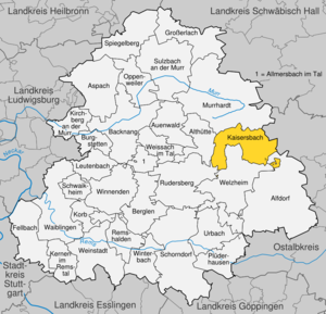
| Location of the municipality of Kaisersbach in the Rems-Murr district | ||
Kaisersbach is a municipality in the Rems-Murr district in Baden-Württemberg .
geography
location
Kaisersbach has a share in the natural areas of the Swabian-Franconian Forest Mountains as well as Schurwald and Welzheimer Forest. Both belong to the Swabian Keuper-Lias-Land .
Community structure
The municipality of Kaisersbach includes 43 spatially separated villages, hamlets, farms and houses; the village of Kaisersbach, the hamlets of Birkhof, Bruch, Cronhütte, Ebersberg, Ebni, Eulenhof, Gibweiler, Gibweiler-Gehren, Gmeinweiler, Menzles, Mönchhof, Schadberg, Schillinghof, Strohhof, Täle, Weidenbach, Ziegelhütte, the courtyards Brandhöfle, Ebersbergmühle, Fratzenklingenhof, Fratzenwiesenhof, Gallenhöfle, Hägerhof, Kellerklinghöfle, Killenhof, Rotbachhöfle, Rotenmad, Sägbühl, Schmalenberg, Silberhäusle, Spatzenhof and the living areas Gibweiler, Sägmühle, Grairich, Grasgehren, Heppichgehren, Höfenäckerle, Kaltenbronnhof, Voggenmühlhöfle, Wsteelmühlhöfle, Menzidenbronnhof, Klingenmühlhöfle. The abandoned residential areas Holzbuckel and Hofstatt are in the area of the municipality of Kaisersbach.
Division of space

According to data from the State Statistical Office , as of 2014.
history
Kaisersbach was first mentioned in 1375 in connection with a transfer of ownership from Staufer property to the Adelberg monastery . In 1382 it also acquired the property of the Stetten chiefs and then exercised all local authority rights. During the Reformation , Kaisersbach became part of Württemberg and from then on belonged to the newly established Adelberg Monastery Office . The community came to the Oberamt Welzheim in 1807 and to the Waiblingen district in 1938 . In 1973, the old districts of Backnang and Waiblingen formed the Rems-Murr district, to which Kaisersbach today belongs. The community retained its independence during the community reform and was able to incorporate the former suburbs of the city of Murrhardt, Weidenhof, Weidenbach and Bruch on January 1, 1973.
Due to the development of the new construction areas Haldenäcker and Bühläcker, the number of inhabitants will probably increase in the next few years. Further new building areas are planned.
politics
mayor
Acting mayor has been Katja Müller since 2014.
Municipal council
The municipal council in Kaisersbach has 12 members. In the local elections on May 26, 2019 , the local council was elected by majority vote. Majority voting takes place if no or only one nomination has been submitted. The applicants with the highest number of votes are then elected. The municipal council consists of the voluntary councilors and the mayor as chairman. The mayor is entitled to vote in the municipal council.
Attractions
- Hägelesklinge nature reserve
- Ebnisee
- Welzheimer forest
- Summer toboggan run
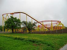
- Schwabenpark in the Gmeinweiler district
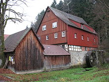
- Menzlesmühle on the Mühlenwanderweg
- Gallen grotto at Ebnisee
Buildings
In Kaisersbach there is a newly clad water tower and a Protestant church. The water tower is no longer open.
Regular events
- May 1st Hocketse at Hüttenbühlsee
- Fire brigade festival with demonstration exercise in the center of the village.
- Sandland summer festival
- Country and western festival in Ebni
- Ebnisee horse rally
education
Kaisersbach has a primary school. Secondary schools must be attended in the neighboring communities (e.g. Welzheim ). 2 km outside the village there is a school camp in the Rems-Murr district in the Mönchhof district.
Personalities
Sons and daughters of the church
- Gotthilf Bayh (1888–1969), politician (SPD), member of the state parliament
Web links
Individual evidence
- ↑ State Statistical Office Baden-Württemberg - Population by nationality and gender on December 31, 2018 (CSV file) ( help on this ).
- ↑ Nature area profile Swabian-Franconian Forest Mountains (108) - LUBW (PDF; 12.5) MB; Notes )
- ↑ Schurwald and Welzheimer Wald natural area profile (107) - LUBW (PDF; 9.1 MB; notes )
- ↑ Main natural areas of Baden-Württemberg (PDF; 3.1 MB), changes (PDF; 2.4 MB; pp. 55–58) - LUBW ( notes )
- ↑ Natural areas of Baden-Württemberg . State Institute for the Environment, Measurements and Nature Conservation Baden-Württemberg, Stuttgart 2009.
- ^ The state of Baden-Württemberg. Official description by district and municipality. Volume III: Stuttgart District, Middle Neckar Regional Association. Kohlhammer, Stuttgart 1978, ISBN 3-17-004758-2 , pp. 570-572.
- ↑ State Statistical Office, area since 1988 according to actual use for Kaisersbach.
- ^ Federal Statistical Office (ed.): Historical municipality directory for the Federal Republic of Germany. Name, border and key number changes in municipalities, counties and administrative districts from May 27, 1970 to December 31, 1982 . W. Kohlhammer, Stuttgart / Mainz 1983, ISBN 3-17-003263-1 , p. 459 .


