
Waiblingen district
| coat of arms | Germany map | |
|---|---|---|

|
Coordinates: 48 ° 50 ' N , 9 ° 25' E |
|
| Basic data (as of 1972) | ||
| Existing period: | 1938-1972 | |
| State : | Baden-Württemberg | |
| Administrative region : | North Württemberg | |
| Administrative headquarters : | Waiblingen | |
| Area : | 438 km 2 | |
| Residents: | 243,725 (May 27, 1970) | |
| Population density : | 556 inhabitants per km 2 | |
| License plate : | WN | |
| Circle key : | 08 1 49 | |
| Circle structure: | 61 municipalities | |
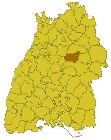
| Location of the Waiblingen district in Baden-Württemberg | ||
  |
||


The district of Waiblingen was a district in Baden-Württemberg , which was dissolved in the course of the district reform on January 1, 1973 .
geography
location
The district of Waiblingen was in the middle of Baden-Württemberg .
Geographically, he had a share in the Swabian-Franconian Forest . The Rems , a tributary of the Neckar, flowed through the western district .
Neighboring areas
Its neighboring districts were 1972 clockwise beginning in the north of Backnang , Schwäbisch Gmünd , Göppingen , Esslingen , Stuttgart and Ludwigsburg .
history
The area of the Waiblingen district belonged mainly to Württemberg before 1800 . Therefore, it existed before 1800, the upper offices Waiblingen and Schorndorf , in addition to the upper office Lorch had shares in the future the district. From 1810, the upper offices belonged to the Landvogtei Rothenberg (Waiblingen) or to the Fils and Rems (Schorndorf and Lorch). From 1818 the Oberamt Waiblingen belonged to the Neckar District , the Oberamt Schorndorf and Lorch (from 1819 Welzheim) to the Jagstkreis , both of which were dissolved in 1924. In 1934 the senior offices were renamed to districts and in 1938 the districts of Welzheim and Schorndorf were dissolved. Most of the communities in the Schorndorf district and some communities in the Welzheim district came to the Waiblingen district, while others also came to the Schwäbisch Gmünd and Göppingen districts. At the same time, the Waiblingen district gave some communities to the Ludwigsburg district, so that it reached its last known expansion. In 1945 the Waiblingen district became part of the newly formed state of Württemberg-Baden , which was merged into the state of Baden-Württemberg in 1952 . From then on he belonged to the administrative region of North Württemberg, which included the Württemberg part of Württemberg-Baden.
With effect from January 1, 1973, the Waiblingen district was dissolved. His communities were completely absorbed in the newly founded Rems-Murr district , which became the legal successor to the Waiblingen district.
Population development
All population figures are census results.
|
|
politics
District Administrator
The district councils of the district Waiblingen 1939-1972:
- 1939–1945: Karl Sinn
- 1945–1946: Anton Schmidt
- 1947–1948: Fritzmartin Ascher
- 1948–1950: Karl Georg Pfleiderer , DVP
- 1950–1973: Werner Bertheau
The Oberamtmen 1804–1938 of the former Oberamt are shown under Oberamt Waiblingen .
coat of arms
The coat of arms of the Waiblingen district showed a three-headed, red-armored, black eagle in gold. The coat of arms was awarded to the district of Waiblingen on July 8, 1957 by the Baden-Württemberg Ministry of the Interior .
The eagle is supposed to indicate the empire, after the district area previously belonged to the Salians and Staufers. The three-headed eagle is intended to refer to the former Oberämter Waiblingen, Schorndorf and Welzheim.
Economy and Infrastructure
traffic
There was no federal motorway running through the district , it was opened up by federal roads 14 and 29 as well as several state and district roads.
Communities
From 1938 onwards, 61 municipalities initially belonged to the Waiblingen district, including 5 towns.
On March 7, 1968, the state parliament of Baden-Württemberg set the course for a community reform . With the law to strengthen the administrative power of smaller municipalities , it was possible for smaller municipalities to voluntarily unite to form larger municipalities. The beginning in the district of Waiblingen was made on January 1st, 1970 by the municipalities of Oberurbach and Unterurbach, which merged to form the new municipality of Urbach. In the period that followed, the number of communities steadily decreased until the Waiblingen district was finally dissolved on January 1, 1973.
The largest municipality in the district was the city of Fellbach , which has been a major district town since April 1, 1956 . The smallest communities were Ödernhardt (in 1961) and Bretzenacker (in 1970).
In the table, the municipalities of the Waiblingen district are before the municipal reform. Today all communities belong to the Rems-Murr-Kreis. The population figures refer to the census results in 1961 and 1970.
License Plate
On July 1, 1956, the district was assigned the distinctive sign WN when the vehicle registration number that is still valid today was introduced . It is still issued in the Rems-Murr district to this day.
Individual evidence
- ↑ a b Federal Statistical Office (ed.): Historical municipality register for the Federal Republic of Germany. Name, border and key number changes in municipalities, counties and administrative districts from May 27, 1970 to December 31, 1982 . W. Kohlhammer, Stuttgart / Mainz 1983, ISBN 3-17-003263-1 , p. 458 f .
.svg)
Basking | Backnang | Baden-Baden | Balingen | Biberach | Boeblingen | Bruchsal | Book | Bühl | Calw | Crailsheim | Donaueschingen | Ehingen | Emmendingen | Esslingen | Freiburg (city) | Freiburg (State) | Freudenstadt | Friedrichshafen | Göppingen | Hechingen | Heidelberg (city) | Heidelberg (Country) | Heidenheim | Heilbronn (city) | Heilbronn (Land) | Black Forest | Horb | Karlsruhe (city) | Karlsruhe (State) | Throat | Constance (city) | Constance (Country) | Künzelsau | Lahr | Leonberg | Loerrach | Ludwigsburg | Mannheim (city) | Mannheim (State) | Mergentheim | Mosbach | Muellheim | Münsingen | Neustadt | Nürtingen | Offenburg | Öhringen | Pforzheim (city) | Pforzheim (Country) | Rastatt | Ravensburg | Reutlingen | Rottweil | Säckingen | Saulgau | Schwäbisch Gmünd | Schwäbisch Hall | Sigmaringen | Sinsheim | Stockach | Stuttgart | Tauberbischofsheim | Tettnang | Tübingen | Tuttlingen | Überlingen | Ulm (city) | Ulm (State) | Vaihingen | Villingen | Villingen-Schwenningen | Waiblingen | Waldshut | Cheeks | Wolfach