
Tauberbischofsheim district
| coat of arms | Germany map | |
|---|---|---|

|
Coordinates: 49 ° 40 ′ N , 9 ° 40 ′ E |
|
| Basic data (as of 1972) | ||
| Existing period: | 1938-1972 | |
| State : | Baden-Württemberg | |
| Administrative region : | North Baden | |
| Administrative headquarters : | Tauberbischofsheim | |
| Area : | 777 km 2 | |
| Residents: | 82,260 (May 27, 1970) | |
| Population density : | 106 inhabitants per km 2 | |
| License plate : | TBB | |
| Circle key : | 08 2 39 | |
| Circle structure: | 84 municipalities | |
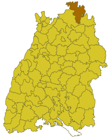
| Location of the Tauberbischofsheim district in Baden-Württemberg | ||
  |
||

The Tauberbischofsheim district was a district in Baden-Württemberg that was dissolved on January 1, 1973 as part of the Baden-Württemberg district reform .
geography
location
The district of Tauberbischofsheim was in the northeast of Baden-Württemberg .
Geographically, he had a share in the building land and in the foothills of the Spessart . The district town of Tauberbischofsheim was roughly in the middle of the district.
Neighboring areas
Its neighboring districts were in the beginning of 1972 clockwise starting in the northwest Miltenberg , Marktheidenfeld , Würzburg , Ochsenfurt (all in Bavaria ), Mergentheim , Künzelsau and Buchen .
history
Background: District Office Tauberbischofsheim
Before 1803, the area of the Tauberbischofsheim district belonged mainly to the monasteries Mainz and Würzburg as well as to the county of Wertheim and the Electoral Palatinate. In 1806 the land came to Baden , which was elevated to a Grand Duchy in 1806 . Initially, a large number of offices were created , the areas of which changed several times in the following years. It was not until 1813 that the offices or district offices of Boxberg , Gerlachsheim , Tauberbischofsheim and Wertheim came into being , with the Wertheim office initially being divided into a city and first rural office and a second rural office until it was merged in 1819.
In 1857 the Office Boxberg was dissolved and its communities assigned to the Office Krautheim . The seat of the enlarged office was initially Krautheim, but again Boxberg from 1863. In 1864 the Gerlachsheim office was dissolved and its communities assigned to the Tauberbischofsheim office. In 1872 the Office Boxberg was dissolved again, re-established in 1898 and finally dissolved in 1924. Most of his communities came to the Tauberbischofsheim district office, some also to the Adelsheim office, which in turn was dissolved in 1936. The law on the redistribution of internal administration of June 30, 1936 repealed the district office Wertheim and assigned all of its communities to the district office Tauberbischofsheim.
From the district office to the Tauberbischofsheim district
With Section 1 (3) of the Third Ordinance on the Rebuilding of the Reich of November 28, 1938 (RGBl. I, p. 1675), these administrative districts were given the designation Landkreis with effect from January 1, 1939 .
In the district of Tauberbischofsheim, a total of 22,509 displaced persons from the areas beyond the Oder-Neisse line , Hungary and the Sudetenland found a new home after the Second World War by the end of 1946 .
Dissolution of the district
After the formation of the state of Baden-Württemberg in 1952, the district of Tauberbischofsheim belonged to the administrative district of North Baden . With effect from January 1, 1973, the Tauberbischofsheim district was dissolved, and its communities were completely absorbed into the Tauber district , which was newly formed together with the Mergentheim district and thus became the legal successor to the Tauberbischofsheim district. In 1974 the new district was given its current name Main-Tauber-Kreis .
Population development
All population figures are census results.
|
|
politics
District Administrator
The senior officials or district administrators of the district office (1813 to 1938) and the district of Tauberbischofsheim (1939 to 1972):
- 1813–1827: Carl Valentin Dölling
- 1828–1830: Joseph Maximilian Dreyer
- 1830–1833: Johannes Bach
- 1833–1841: Ludwig Frobenius von Dürrheim
- 1841–1848: Anton Schneider
- 1848–1855: Maximilian Ruth
- 1855–1860: Leopold Rieder
- 1860–1877: Matthias Schmieder
- 1877: Adolf Fuchs
- 1877–1882: Otto Frey
- 1882–1886: Anton Rasina
- 1886-1893: Albert Jung
- 1893–1898: Edmund Lang
- 1898–1902: Konrad Kretzdorn
- 1902–1918: Emil Bitzel
- 1919–1921: Ernst Klotz
- 1921–1933: Ludwig Vesenbeckh
- 1933–1935: Friedrich Denzel
- 1935–1937: Hans Goll
- 1937–1945: Klaus Tellenbach
- 1945: Carl Roth
- 1945–1946: Richard Reile
- 1946–1948: Hermann Götz
- 1948–1964: Anton Schwan
- 1964–1972: Bruno Rühl
coat of arms
The coat of arms of the Tauberbischofsheim district showed in a four-sided shield: 1 in gold a six-spoke red wheel with a gold hub, 2 in black a red crowned and red armored golden lion, 3 in black a slanting, notched flag on a golden rod, embroidered with red and silver ; 4 in gold a blue heraldic rose. The coat of arms was awarded on March 19, 1959 by the Baden-Württemberg Ministry of the Interior .
The coat of arms symbolizes the former domains that divided the district until 1803. The wheel stands for the communities that belonged to the Mainz Archbishopric , the lion for the former Electoral Palatinate communities, the flag for the places of the Hochstift Würzburg and the rose is the coat of arms of the Counts of Wertheim .
Economy and Infrastructure
traffic
The federal highways 27 and 290 run through the district area.
Communities
From 1938 onwards, 84 municipalities initially belonged to the Tauberbischofsheim district, including 7 towns. In 1939 Niklashausen was merged with the municipality of Höhefeld, but then re-established as an independent municipality in 1960.
On March 7, 1968, the state parliament of Baden-Württemberg set the course for a community reform . With the law to strengthen the administrative power of smaller municipalities , it was possible for smaller municipalities to voluntarily unite to form larger municipalities. It all started with five communities in the Tauberbischofsheim district when they merged with their neighboring communities on July 1, 1971, namely Kupprichhausen and Unterschüpf with Boxberg , Hundheim with Külsheim, and Hochhausen and Impfingen with Tauberbischofsheim . Even after that, the number of communities steadily decreased until the district of Tauberbischofsheim was finally dissolved on January 1, 1973.
The largest municipality in the district was the city of Wertheim . The smallest community was Brunntal.
In the table, the municipalities of the Tauberbischofsheim district are before the municipal reform. All today's communities belong to the Main-Tauber district. The population figures refer to the census results in 1961 and 1970.
Footnote:
1 Niklashausen was united with the municipality of Höhefeld from 1939 to 1960
License Plate
On July 1, 1956, the district was assigned the TBB distinctive sign when the vehicle registration number that is still valid today was introduced . It is still issued in the Main-Tauber district to this day.
literature
- Wolfram Angerbauer (Red.): The heads of the upper offices, district offices and district offices in Baden-Württemberg from 1810 to 1972 . Published by the working group of the district archives at the Baden-Württemberg district assembly. Theiss, Stuttgart 1996, ISBN 3-8062-1213-9 .
Web links
Individual evidence
- ↑ a b c d Wolfram Angerbauer (Red.): The heads of the upper offices, district offices and district offices in Baden-Württemberg 1810 to 1972 . Published by the working group of the district archives at the Baden-Württemberg district assembly. Theiss, Stuttgart 1996, ISBN 3-8062-1213-9 , pp. 85-88 .
- ↑ Austrian National Library: German Reich Law Gazette Part I 1867–1945. No. 201 - Date of issue: November 29, 1938 . Online at alex.onb.ac.at. Retrieved May 13, 2016.
- ↑ Main-Post : 18 square meters for six people. 60 years ago, the first transports with people who had been expelled from Hungary arrived by rail in what was then the district of Tauberbischofsheim. . Online at www.mainpost.de. April 11, 2006. Retrieved December 11, 2015.
- ↑ a b Federal Statistical Office (ed.): Historical municipality register for the Federal Republic of Germany. Name, border and key number changes in municipalities, counties and administrative districts from May 27, 1970 to December 31, 1982 . W. Kohlhammer, Stuttgart / Mainz 1983, ISBN 3-17-003263-1 , p. 480 f .
- ^ Franz Gehrig , Hermann Müller: Tauberbischofsheim . Association of Tauberfränkische Heimatfreunde e. V., Tauberbischofsheim 1997, p. 303f. (The Grand Ducal Baden Oberamtmen).
.svg)
Basking | Backnang | Baden-Baden | Balingen | Biberach | Boeblingen | Bruchsal | Book | Bühl | Calw | Crailsheim | Donaueschingen | Ehingen | Emmendingen | Esslingen | Freiburg (city) | Freiburg (State) | Freudenstadt | Friedrichshafen | Göppingen | Hechingen | Heidelberg (city) | Heidelberg (Country) | Heidenheim | Heilbronn (city) | Heilbronn (Land) | Black Forest | Horb | Karlsruhe (city) | Karlsruhe (State) | Throat | Constance (city) | Constance (Country) | Künzelsau | Lahr | Leonberg | Loerrach | Ludwigsburg | Mannheim (city) | Mannheim (State) | Mergentheim | Mosbach | Muellheim | Münsingen | Neustadt | Nürtingen | Offenburg | Öhringen | Pforzheim (city) | Pforzheim (Country) | Rastatt | Ravensburg | Reutlingen | Rottweil | Säckingen | Saulgau | Schwäbisch Gmünd | Schwäbisch Hall | Sigmaringen | Sinsheim | Stockach | Stuttgart | Tauberbischofsheim | Tettnang | Tübingen | Tuttlingen | Überlingen | Ulm (city) | Ulm (State) | Vaihingen | Villingen | Villingen-Schwenningen | Waiblingen | Waldshut | Cheeks | Wolfach