
Gamburg
|
Gamburg
municipality Werbach
|
|
|---|---|
 |
|
| Height : | 176 m above sea level NN |
| Area : | 10.02 km² |
| Residents : | 666 (Dec. 31, 2013) |
| Population density : | 66 inhabitants / km² |
| Incorporation : | 1st January 1975 |
| Postal code : | 97956 |
| Area code : | 09348 |
 Gamburg
|
|
Gamburg (in the Taubergründischen dialect Gammri ) is a district of the municipality Werbach in the Main-Tauber-Kreis in Baden-Württemberg. The formerly independent municipality has been part of the Werbach municipality since 1975 and had 666 inhabitants on December 31, 2013.
geography
Geographical location
Gamburg is located in the lowest narrow section of the Tauber valley , at a former ford of the river and the confluence of the Maisenbach into the Tauber, belonging to the landscape of the Tauberland with the transition from the limestone soils to the red sandstone sediments. Politically, Gamburg is located on the border between Baden-Württemberg and Bavaria.
Village structure
![]() Map with all coordinates of the residential areas in the district of Gamburg: OSM
Map with all coordinates of the residential areas in the district of Gamburg: OSM
For the district of the district Gamburg belong next to the village Gamburg the residential places Eulschirben , Bimssteinfabrik , Dorfmuhle , station Gamburg , Gasthof Tauber pearl , Lindh Elle , furniture factory and Schlossberg .
history
middle Ages
Excavations show repeated traces of settlement on the right bank of the river, in the old churches corridor from the La Tène period and in the Leidenäcker corridor from the Urnfield period . The name Gamburg is documented for the first time from the time of the Würzburg bishop Erlung for the noble free of Gamburg, who named themselves after "Gamans fortress" ( Gammenburc ), probably a predecessor of today's castle. Around 1137 the place Gamburg is mentioned for the first time in the property register of the Archbishop of Mainz Adalbert .
A bridge later replaced the ford. The legends of the Hokemo and the Melusine were also made during this period . A mayor of Gamburg was mentioned for the first time in 1219, and in 1248 the village mill was mentioned for the first time . The village was fortified by hag fences, trenches and gates that formed a belt and a unit that was included in the castle's defense system and in which the population found protection. Remains of a gate tower with fortification walls towards the castle ( the Krappentor tower ) are still preserved.
Modern times
A church had stood in Gamburg since 1404 at the latest. In 1567, work began on converting into a new parish church on today's Rathausplatz. There are three stone crosses on this square today. On the base of the middle cross it says: " This is where the high altar of the old parish church was from 1567 to 1895. " A pencil drawing of the old church was made by Sir Joseph Archer Crowe shortly before it was demolished in 1896 . The original is owned by the Alberts family.
From 1720 the first stone bridge over the Tauber was built. From 1845 to 1930 over 300 Gamburger emigrated to America.
With the Lauda – Wertheim railway line, which was completed in 1868 , the place received a train station with goods and travel services and thus a connection to the nearest larger cities of Tauberbischofsheim and Wertheim .
In 1915 the last of the five gates in the town wall, the mill gate, was demolished.
On January 1, 1975, the political independence ended with the incorporation into the municipality of Werbach.
In 1989 a tusk of a mammoth was found below the Lindhelle corridor during excavation work for a rain overflow basin at a depth of about five meters, which broke in the process. After the restoration, it was taken to the Wertheim Historical Museum .
In 2008 the primary school was given up and later demolished. In 2011 the local kindergarten was also closed and merged with the existing one in the Niklashausen district.

Well in the center of the village

Tauber Bridge
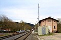
railway station

Buscher birth house

oldest wayside shrine in the Taubertal


.jpg)


Culture and sights
Cultural monuments
Memorials

In the cemetery there is a separate grove of honor with the graves and headstones of those who died in the First and Second World Wars.
museum
The Gamburger Buscher Museum (GBM) with works by the Buscher family has been open to the public since October 13, 2013.
A circular path ( called the Buscher path ) leads through the village to the places where the artists worked. Information boards in front of the buildings have more information on this.
Buildings

- Castle and Castle Park Gamburg (also Upper Castle Gamburg ), built in the 12th century, monument of national importance with the oldest secular wall paintings north of the Alps
- Eulschirbenmühle , Mühle an der Tauber, first mentioned in 1245, today's building from the late 16th century
- Dorfmühle- ( Lang) an der Tauber, first mentioned in a document in 1248. Today E-Werk.
- Parish church of St. Martin , first mentioned in 1404, today's building built between 1895 and 1898
- 14 St. Chapel on the hiking trail to the Bauernwald, built in 1823.
- Maria-Hilf-Chapel (Ingelheim'sche Chapel) in the Kammerforst, built in 1834.
- Joseph's Chapel in the upper Maisenbachtal, built in 1891.
- Lower Gamburg Castle , built in 1522 by Johann Kuchenmeister
- Tower, with the remains of the village fortifications and archway ( Krappentor )
- Sundial, the so-called sun gate of time
- Railway station, in 1886 the station building with attached goods shed was completed.
- Pumice stone factory (previously oil mill), founded in 1897 and in operation until 2002, manufacturer of the Gamburger Mäusen , a small pumice stone for cleaning hands.
- Furniture factory , formerly Oetzel furniture factory, in Fabrikstrasse. It was founded in 1936, but is now closed and serves as a warehouse
Regular events

- annual ceremonial meeting and street parade of the carnival club
- annual Laetare move of the home club
- monthly bird exchange of the association bird lovers and breeders Taubertal e. V. (every 1st Saturday of the month)
music
A music band has existed ( with interruption ) in Gamburg since 1898. The music association that exists today primarily serves to maintain folk music.
Economy and Infrastructure
traffic
railroad
Gamburg is connected to rail traffic by the Lauda – Wertheim line ; regional trains run in the direction of Aschaffenburg and Crailsheim. In Lauda there is a connection to the Frankenbahn, which connects Würzburg with Stuttgart.
Road traffic
Gamburg can be reached via the L 506 from Tauberbischofsheim ( BAB 81 ) or Wertheim ( BAB 3 ).
Public bus
There is regular bus service operated by the Main-Tauber transport company (VGMT), with two stops in town. ( Train station and Tauberperle stop )
Biking and hiking trails
Gamburg can be reached via the Liebliches Taubertal cycle path, the classic, also known as the Taubertal cycle path . The Taubertal Panorama Trail and the approximately 180 km long Jakobsweg Main-Taubertal also lead through Gamburg. In 2019, the European cultural route of the Archaeological Spessart project was opened between Gamburg, Niklashausen , Höhefeld and Bronnbach .
Established businesses
Gamburg is home to a number of larger companies, such as Hofmann Naturstein .
Personalities
Personalities from Gamburg can be seen in the main article.
Web links
- Gamburg at LEO-BW
Individual evidence
- ↑ Website of the municipality of Werbach (accessed on January 12, 2015)
- ↑ LEO-BW.de: Eulschirben - living space . Online at www.leo-bw.de. Retrieved April 19, 2018.
- ↑ LEO-BW.de: Pumice stone factory - Gone . Online at www.leo-bw.de. Retrieved April 19, 2018.
- ↑ LEO-BW.de: Dorfmühle - living space . Online at www.leo-bw.de. Retrieved April 19, 2018.
- ↑ LEO-BW.de: Gamburg, train station - living space . Online at www.leo-bw.de. Retrieved April 19, 2018.
- ↑ LEO-BW.de: Gasthof Tauberperle - up . Online at www.leo-bw.de. Retrieved April 19, 2018.
- ↑ LEO-BW.de: Lindhelle - living space . Online at www.leo-bw.de. Retrieved April 19, 2018.
- ↑ LEO-BW.de: Furniture factory - Aufgommen . Online at www.leo-bw.de. Retrieved April 19, 2018.
- ↑ LEO-BW.de: Schlossberg - living space . Online at www.leo-bw.de. Retrieved April 19, 2018.
- ^ Federal Statistical Office (ed.): Historical municipality directory for the Federal Republic of Germany. Name, border and key number changes in municipalities, counties and administrative districts from May 27, 1970 to December 31, 1982 . W. Kohlhammer, Stuttgart / Mainz 1983, ISBN 3-17-003263-1 , p. 469 .
- ^ Gerhard Bund: Mammoth tooth brought to light during excavation work in Gamburg . In: Fränkische Nachrichten of January 24, 1989
- ↑ "The Classic" - Tourist Association of Liebliches Taubertal. In: liebliches-taubertal.de. Retrieved August 3, 2020 .
- ↑ 3rd day stage - Tauberbischofsheim to Wertheim - Liebliches Taubertal tourist office. In: liebliches-taubertal.de. Retrieved August 3, 2020 .
- ↑ Panoramaweg Taubertal - Tourist Association Liebliches Taubertal. In: liebliches-taubertal.de. Retrieved August 3, 2020 .
- ↑ Taubertal panorama hiking trail (long-distance hiking trail) - wanderkompass.de. In: wanderkompass.de. Retrieved August 3, 2020 .
- ↑ Jakobsweg Main-Taubertal (pilgrimage route) - wanderkompass.de. In: wanderkompass.de. Retrieved August 3, 2020 .