Gamburg train station
|
Gamburg train station
municipality Werbach
Coordinates: 49 ° 41 ′ 52 " N , 9 ° 35 ′ 40" E
|
|
|---|---|
| Postal code : | 97956 |
|
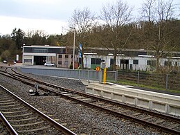
View of the industrial area and residential area of the Gamburg train station on a car-free cycling Sunday, 2019
|
|
Gamburg railway station is an industrial area as well as a residential area on the outskirts of the Werbach district of Gamburg in the Main-Tauber district in northeast Baden-Württemberg . The Gamburg train station, which gives it its name , is on site.
geography
Industrial area and residential area Bahnstation Gamburg is located about 750 meters northwest of the old town center of Gamburg. The Tauber leads past the living space. The 282 meter high Neuberg rises north-northwest of the residential area.
history
The living space came to the municipality of Werbach on January 1, 1975 as part of the formerly independent municipality of Gamburg.
The history of the Taubertalbahn station:
Cultural monuments
Cultural monuments of the industrial area and residential area at the Gamburg railway station are listed in the list of cultural monuments in Gamburg .
traffic
Rail transport
The Lauda – Wertheim railway line passes the residential area. There is the spot Gamburg station and a rail connection to a factory building.
Road traffic
The industrial area and residential area at the Gamburg railway station can be reached via the Anton-Hofmann-Allee branching off from the L 506 (known as Bahnhofstrasse in the local area ) . In addition, there is the Höhefelder Weg street at the residential area, which leads in the direction of the Wertheim village of Höhefeld .
Web links
- Gamburg, Bahnstation - Wohnplatz on the leo-bw.de website
Individual evidence
- ↑ a b c d LEO-BW.de: Gamburg, train station - living space . Online at www.leo-bw.de. Retrieved April 9, 2018.
- ^ Federal Statistical Office (ed.): Historical municipality directory for the Federal Republic of Germany. Name, border and key number changes in municipalities, counties and administrative districts from May 27, 1970 to December 31, 1982 . W. Kohlhammer, Stuttgart / Mainz 1983, ISBN 3-17-003263-1 , p. 469 .

