
Werbach
| coat of arms | Germany map | |
|---|---|---|

|
Coordinates: 49 ° 40 ' N , 9 ° 38' E |
|
| Basic data | ||
| State : | Baden-Württemberg | |
| Administrative region : | Stuttgart | |
| County : | Main-Tauber district | |
| Height : | 187 m above sea level NHN | |
| Area : | 43.18 km 2 | |
| Residents: | 3320 (Dec. 31, 2018) | |
| Population density : | 77 inhabitants per km 2 | |
| Postal code : | 97956 | |
| Primaries : | 09341, 09348, 09349 | |
| License plate : | TBB, MGH | |
| Community key : | 08 1 28 128 | |
| LOCODE : | DE WCC | |
| Address of the municipal administration: |
Hauptstrasse 59 97956 Werbach |
|
| Website : | ||
| Mayor : | Ottmar Dürr | |
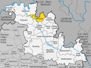
| Location of the community of Werbach in the Main-Tauber district | ||
  |
||


Werbach is a municipality in Tauberfranken and belongs to the Main-Tauber district in the Franconian north-east of Baden-Württemberg . The community became famous for its Liebfrauenbrunn pilgrimage chapel.
geography
Geographical location
Werbach is located in the Taubertal between Tauberbischofsheim , Wertheim and Würzburg .
Community structure

The municipality of Werbach includes the formerly independent municipalities of Brunntal , Gamburg , Niklashausen , Wenkheim and Werbachhausen .
![]() Map with all coordinates of the places of the municipality Werbach: OSM
Map with all coordinates of the places of the municipality Werbach: OSM
- The village of Brunntal ( ⊙ ) belongs to the former municipality of Brunntal .
- The former municipality of Gamburg includes the village of Gamburg ( ⊙ ), Eul (Eil) schirben ( ⊙ ) homestead and residential area , the pumice stone factory ( ⊙ ), Dorfmühle ( ⊙ ), Gamburg railway station ( ⊙ ), Gasthof Tauberperle ( ⊙ ), Lindhelle ( ⊙ ), furniture factory ( ⊙ ) and Schlossberg ( ⊙ ).
- The former municipality of Niklashausen includes the village of Niklashausen ( ⊙ ) and the residential areas of the Altes Bahnwärterhaus ( ⊙ ) and the Niklashausen stop ( ⊙ ) as well as the abandoned village of Helzenberg.
- The former municipality of Wenkheim includes the Wenkheim ( ⊙ ), the Neumühle ( ⊙ ), Öl- und Sägmühle ( ⊙ ) and Seemühle ( ⊙ ) farms and the Mehlen residential area ( ⊙ ).
- The village of Werbach ( ⊙ ) and the residential areas Blauer Rain ( ⊙ ), Fischzuchtanstalt ( ⊙ ), Schneidmühle ( ⊙ ), Steinig ( ⊙ ), Weidenmühle ( ⊙ ) and Welzmühle ( ⊙ ) belong to the municipality of Werbach within the borders of December 31, 1973 ).
- The village of Werbachhausen ( ⊙ ), the Emmentaler Mühle ( ⊙ ) and the abandoned Mühlenbau-Werkstätte ( ⊙ ) residential area belong to the former municipality of Werbachhausen .
Protected areas

In Werbach there is a European bird sanctuary , two landscape and four nature reserves :
- European bird sanctuary Heiden und Wälder Tauberland (protected area identifier DE-6323-441); since 2007.
- Main-Tauber-Tal protected landscape area : 2988.0 ha; Tauberbischofsheim and Werbach districts; since 1953.
- Werbach landscape protection area : 2125.0 ha; Districts Werbach, Werbachhausen, Wenkheim and Gamburg; since 1985.
- Apfelberg nature reserve : 22.5 ha; Werbach community, Gamburg district
- Helmental-Kleinleiden nature reserve , 15.4 ha; Werbach community, Werbachhausen district
- Lindenberg nature reserve : 8.7 ha; Werbach community, Werbach district
- Wormental nature reserve : 19.2 ha; Werbach community, Werbach districts.
- Welzbachtal water protection area (WSG No. 128131); 2442.43 ha; since February 3, 2004. It is one of the largest water protection areas in the Main-Tauber district .
In addition, there are a total of 14 protected natural monuments in the area of the municipality of Werbach .
Division of space

According to data from the State Statistical Office , as of 2014.
history
History of the community of Werbach
middle Ages
The first written mention of Werbach comes from 1248 .
Modern times
In 1563 the plague kills almost 500 people in Werbach. During the German War , on July 24, 1866, there was a battle near Werbach between Baden and Oldenburg military units, with the Oldenburg allied with Prussia occupying Werbach.
Incorporations
In the course of the community reform in Baden-Württemberg on December 31, 1973, the previously independent communities of Werbach, Wenkheim, Werbachhausen and Brunntal were merged to form the new community of Werbach. On January 1, 1975, this community merged with Gamburg and Niklashausen to form today's community.

Werbach (old)

Werbach's districts and their history
Brunntal

Brunntal is first mentioned in a document in 1222. At that time parts of the village were donated to Würzburg. In the 14th century, the Bronnbach monastery was also wealthy in Brunntal . Until 1803 the village belonged to Kurmainz . As part of the secularization due to the Reichsdeputationshauptschluss , the place was assigned to the Principality of Leiningen . After its dissolution in 1806 as part of the Rhine Confederation Act , it became the Grand Duchy of Baden .
Gamburg

Gamburg was first mentioned in a document as early as 1139. In 1806 the place came under the sovereignty of Würzburg and a year later, through a state treaty between Würzburg and Baden, under the sovereignty of the Grand Duchy of Baden.
Gamburg Castle is the landmark of Gamburg .
Niklashausen


Nicozeshusen, as the village was called earlier, was first mentioned in a document in 1170. The village belonged to the old county of Wertheim, the later county of Löwenstein-Wertheim. Hans Böhm , the Timpanist from Niklashausen , appeared in 1476 as a preacher before the pilgrims in Niklashausen. He manages to gather 40,000 farmers around him. Nevertheless, he was arrested and burned as a heretic in Würzburg. In 1806 the village came under the sovereignty of the Grand Duke of Baden.
Wenkheim

"Weggencheim" was first mentioned in 1149. It is assumed that the gentlemen from Wenkheim, who sat in Thuringia, originally came from here. From 1625 it was part of the Löwenstein-Wertheim county. In 1673 the French burned down Wenkheim Castle. In 1750 a large part of Wenkheim burned down. In 1776 the village was badly devastated in a storm. In 1806 Wenkheim came under the sovereignty of the Grand Duke of Baden.
Werbachhausen

Werbachhausen was first mentioned as Werpachhusen in 1308, and in 1332 as Husin near Wertpach . Several noble families had property in Werbachhausen, which had belonged to Kurmainz since 1592 . From 1803 to 1806 it belonged to the Principality of Leiningen and then came to the Grand Duchy of Baden .
Population development
The total population of the districts of the municipality of Werbach developed as follows:
| year | population |
|---|---|
| 1961 | 3496 |
| 1970 | 3611 |
| 1993 | 3645 |
| 1998 | 3662 |
| 2003 | 3621 |
| 2008 | 3506 |
| 2013 | 3288 |
Sources: Directory of municipalities and information from the State Statistical Office
Community archive
The archive of the municipality of Werbach was brought into the sub-archive of the Main-Tauber district in the Main-Tauber archive network . The archive network was set up in 1988 in the former hospital of the Bronnbach monastery under the auspices of the Wertheim State Archive, which was founded in 1978 .
religion
Christianity
The Catholic Church of St. Martin is in Werbach . The Catholic churches of the community belong to the pastoral care unit Großrinderfeld-Werbach in the deanery Tauberbischofsheim of the Archdiocese of Freiburg .
Judaism
The Jewish community of Wenkheim was founded in the 16th century. The place is known for its Jewish history; Jews are mentioned for the first time in 1576 and 1591. In addition to the former synagogue in Wenkheim , the Jewish community of Wenkheim owned a Jewish school , a ritual bath and the Wenkheim Jewish cemetery . The synagogue was demolished during the November pogrom in 1938 . By 1940 more than half of the Jewish population had emigrated (22 to the USA , 8 to Palestine ). On 22 October 1940, the last 11 Jewish residents were Wenkheims while the Wagner-Bürckel action in the Camp de Gurs deported .
politics
Municipal council
The municipal council has 15 honorary members who are elected for five years. In addition, the mayor acts as the municipal council chairman with voting rights.
The 2019 local elections led to the following result (in brackets: difference to 2014):
| Municipal Council 2019 | ||||
|---|---|---|---|---|
| Party / list | Share of votes | Seats | ||
| Active citizens | 60.3% (+9.0) | 9 (+1) | ||
| Independent Citizens List (UBL) | 39.7% (−9.0) | 6 (−1) | ||
| Turnout: 61.3% (−3.5) | ||||
mayor
Ottmar Dürr took office as mayor in 1999 and was re-elected in 2007 and 2015.
See also: List of the mayors of the Werbach community
coat of arms
The coat of arms shows a red Mainz wheel on a white background over two white roses on a blue background.
Administrative community
The municipality of Werbach forms with the city of Tauberbischofsheim, as well as the municipalities of Großrinderfeld and Königheim, the agreed administrative community of Tauberbischofsheim to handle their administrative business together .
Economy and Infrastructure
Water supply
The Taubertal waterworks, built in Dittigheim from 2015 to 2017, supplies around 40,000 people from three cities and three municipalities, as well as industry and trade in the central Taubertal with drinking water. The operator is the Central Tauber Water Supply Association , which includes the municipalities of Werbach, Großrinderfeld and Wittighausen as well as the towns of Tauberbischofsheim , Lauda-Königshofen and Grünsfeld .
education
wine growing
Werbach is the wine town of the Tauberfranken wine region in the Baden wine-growing region .
traffic
The districts of Niklashausen and Gamburg are connected to the railway network by the Lauda – Wertheim line. In addition, buses run by the Main-Tauber transport company .
Biking and hiking trails
Werbach is on the Taubertal cycle path . The Welzbachtalradweg leads in a north-easterly direction to Oberaltertheim . From there there is a connection via other cycle paths to the Main cycle path near Würzburg. The Taubertal Panorama Trail and the approximately 180-kilometer-long Jakobsweg Main-Taubertal also lead through Werbach.
Culture and sights
Buildings and monuments
Liebfrauenbrunnkapelle

The Liebfrauenbrunn pilgrimage chapel is located between Werbach and Werbachhausen.
Wenkheim Jewish cemetery
In the district of Wenkheim there is a Jewish cemetery , which was created in the 17th century or earlier east of the town in the Gewann "Großer Wald" (today directly on the Baden-Württemberg / Bavaria border) and was occupied until 1938 (parcel 10321, area 55, 80 a).
Other architectural monuments
- St. Martin Church in Werbach
- Former synagogue in Wenkheim - restored by a support association
- Evangelical Church Wenkheim
- Gamburger parish church from 1895
- Gamburg Castle near Gamburg
- Eulschirbenmühle near Gamburg
- Gamburg train station
Sports
The fencing club Future Fencing Werbach , which trains in the Tauberhalle Werbach , won two gold medals at the German fencing championships in 2019 .
Recreation
Tauberinsel youth campground

The DLRG local branch in Werbach operates the Tauberinsel youth campground. The campground is completely from the water of the Tauber flows around.
Wenkheim outdoor pool
There is an outdoor swimming pool in Wenkheim.
Recreation area on the Schleifgraben
The green area in the Werbacher grinding trench is located since 2010 at grinding ditch , the middle estuary of Welzbachs in the Tauber. The recreation area includes a biotope, a Kneipp pool , a bowling alley, a beach volleyball court, a soccer field, a playground and a pump track -Parcours. The Welzbachtal cycle path leads directly past the local recreation area.
- Views of the recreational area at the Werbacher Schleifgraben

The Werbach Kneipp facility on the Schleifgraben

A beach volleyball court and playground next door

A biotope follows immediately after the Kneipp facility
_kurz_vor_Werbach_aus_Richtung_Hochhausen_kommend_-_1.jpg)
_kurz_vor_Werbach_aus_Richtung_Hochhausen_kommend_-_5.jpg)
_-_Blick_von_der_Kneippanlage_bei_Werbach_in_Richtung_Hochhausen_-_1.jpg)
Personalities
Individual evidence
- ↑ State Statistical Office Baden-Württemberg - Population by nationality and gender on December 31, 2018 (CSV file) ( help on this ).
- ^ Main-Tauber-Kreis: Main-Tauber-Kreis: Cities and municipalities. Online at www.main-tauber-kreis.de, accessed on October 25, 2014
- ^ The state of Baden-Württemberg. Official description by district and municipality. Volume IV: Stuttgart district, Franconian and East Württemberg regional associations. Kohlhammer, Stuttgart 1980, ISBN 3-17-005708-1 . Pp. 354-357
- ↑ Additional source on a residential space in Werbach: Mehlen settlement - residential space . Online at www.leo-bw.de. Retrieved December 2, 2017.
- ↑ Brunntal - Altgemeinde ~ Teilort - detail page - LEO-BW. In: leo-bw.de. Retrieved July 19, 2020 .
- ↑ Gamburg - Altgemeinde ~ Teilort - detail page - LEO-BW. In: leo-bw.de. Retrieved July 19, 2020 .
- ↑ Eulschirben - living space - detail page - LEO-BW. In: leo-bw.de. Retrieved July 19, 2020 .
- ↑ Pumice stone factory - Gone - detail page - LEO-BW. In: leo-bw.de. Retrieved July 19, 2020 .
- ↑ Dorfmühle - living space - detail page - LEO-BW. In: leo-bw.de. Retrieved July 19, 2020 .
- ↑ Gamburg train station - living space - detail page - LEO-BW. In: leo-bw.de. Retrieved July 19, 2020 .
- ↑ Gasthof Tauberperle - Gone - detail page - LEO-BW. In: leo-bw.de. Retrieved July 19, 2020 .
- ↑ Lindhelle - living space - detail page - LEO-BW. In: leo-bw.de. Retrieved July 19, 2020 .
- ↑ Furniture factory - up - details page - LEO-BW. In: leo-bw.de. Retrieved July 19, 2020 .
- ↑ Schlossberg - living space - detail page - LEO-BW. In: leo-bw.de. Retrieved July 19, 2020 .
- ↑ Niklashausen - Altgemeinde ~ Teilort - detail page - LEO-BW. In: leo-bw.de. Retrieved July 19, 2020 .
- ↑ Old railway keeper's house - living space - detail page - LEO-BW. In: leo-bw.de. Retrieved July 19, 2020 .
- ↑ Niklashausen stop - living space - detail page - LEO-BW. In: leo-bw.de. Retrieved July 19, 2020 .
- ↑ Helzenberg - Wüstung - detail page - LEO-BW. In: leo-bw.de. Retrieved July 19, 2020 .
- ↑ Wenkheim - Altgemeinde ~ Teilort - detail page - LEO-BW. In: leo-bw.de. Retrieved July 19, 2020 .
- ↑ Neumühle - living space - detail page - LEO-BW. In: leo-bw.de. Retrieved July 19, 2020 .
- ↑ Oil mill - living space - detail page - LEO-BW. In: leo-bw.de. Retrieved July 19, 2020 .
- ↑ Seemühle - living space - detail page - LEO-BW. In: leo-bw.de. Retrieved July 19, 2020 .
- ↑ Settlement Mehlen - living space - detail page - LEO-BW. In: leo-bw.de. Retrieved July 19, 2020 .
- ↑ Werbach - Altgemeinde ~ Teilort - detail page - LEO-BW. In: leo-bw.de. Retrieved July 19, 2020 .
- ↑ Blauer Rain - living space - detail page - LEO-BW. In: leo-bw.de. Retrieved July 19, 2020 .
- ↑ Fish farm - living space - detail page - LEO-BW. In: leo-bw.de. Retrieved July 19, 2020 .
- ↑ Cutting mill - living space - detail page - LEO-BW. In: leo-bw.de. Retrieved July 19, 2020 .
- ↑ Steinig - living space - detail page - LEO-BW. In: leo-bw.de. Retrieved July 19, 2020 .
- ↑ Weidenmühle - living space - detail page - LEO-BW. In: leo-bw.de. Retrieved July 19, 2020 .
- ↑ Welzmühle - living space - detail page - LEO-BW. In: leo-bw.de. Retrieved July 19, 2020 .
- ↑ Werbachhausen - Altgemeinde ~ Teilort - detail page - LEO-BW. In: leo-bw.de. Retrieved July 19, 2020 .
- ↑ Emmentaler Mühle - living space - detail page - LEO-BW. In: leo-bw.de. Retrieved July 19, 2020 .
- ↑ Mühlenbau-Werkstätte - Raised - Detail page - LEO-BW. In: leo-bw.de. Retrieved July 19, 2020 .
- ↑ Reinhard Wolf , Ulrike Kreh (ed.): The nature reserves in the Stuttgart administrative region . Thorbecke, Ostfildern 2007.
- ↑ Ordinance of the Ministry of Food and Rural Areas establishing European Bird Protection Areas (VSG-VO) of February 5, 2010.
- ↑ State Statistical Office, area since 1988 according to actual use for Werbach.
- ^ Federal Statistical Office (ed.): Historical municipality directory for the Federal Republic of Germany. Name, border and key number changes in municipalities, counties and administrative districts from May 27, 1970 to December 31, 1982 . W. Kohlhammer, Stuttgart / Mainz 1983, ISBN 3-17-003263-1 , p. 469 .
- ↑ Information on the history of Werbachhausen at werbach.de (accessed on June 10, 2019)
- ^ Federal Statistical Office (ed.): Historical municipality directory for the Federal Republic of Germany. Name, border and key number changes in municipalities, counties and administrative districts from May 27, 1970 to December 31, 1982 . W. Kohlhammer, Stuttgart / Mainz 1983, ISBN 3-17-003263-1 .
- ↑ Kulturamt Kloster Bronnbach: Archive Association Main-Tauber. In: kloster-bronnbach.de. Retrieved May 24, 2020 .
- ↑ Extended magazine inaugurated in the archive network. In: main-tauber-kreis.de. Retrieved May 24, 2020 .
- ^ State archive Wertheim - State archive Baden-Württemberg. In: landesarchiv-bw.de. Retrieved May 24, 2020 .
- ^ Wenkheim (community of Werbach, Main-Tauber district): Jewish history / synagogue. In: Alemannia Judaica . May 18, 2020, accessed May 26, 2015 .
- ^ State Statistical Office of Baden-Württemberg: Municipal elections 2019, Werbach ; FN-Web , May 26, 2019: Result of the 2019 municipal council election in Werbach ; accessed July 2, 2019.
- ↑ Zweckverband Wasserversorgung Mittlere Tauber: Homepage . Online at www.wvmt.de. Retrieved February 23, 2018.
- ↑ Main-Post: From 2017 drinking water from Dittigheim . October 28, 2016. Online at www.mainpost.de. Retrieved February 23, 2018.
- ↑ "The Classic" - Tourist Association of Liebliches Taubertal. In: liebliches-taubertal.de. Retrieved August 3, 2020 .
- ↑ 3rd day stage - Tauberbischofsheim to Wertheim - Liebliches Taubertal tourist office. In: liebliches-taubertal.de. Retrieved August 3, 2020 .
- ↑ Inlinemap.net: Welzbachtalradweg . Online at www.inlinemap.net. Retrieved May 30, 2017.
- ↑ Panoramaweg Taubertal - Tourist Association Liebliches Taubertal. In: liebliches-taubertal.de. Retrieved August 3, 2020 .
- ↑ Taubertal panorama hiking trail (long-distance hiking trail) - wanderkompass.de. In: wanderkompass.de. Retrieved August 3, 2020 .
- ↑ Jakobsweg Main-Taubertal (pilgrimage route) - wanderkompass.de. In: wanderkompass.de. Retrieved August 3, 2020 .
- ^ Liebfrauenbrunnkapelle , municipality of Werbach, accessed on September 12, 2016
- ↑ Florian Werr : Liebfraubrunn near Werbach: Pilgrimage booklet for the Catholic people. Frankonia, Tauberbischofsheim 1919
Web links
- Official website of the municipality
- Landesarchiv BW - inventory KG 40 - On the history of Werbach
- Apfelberg nature reserve near Werbach

Maple | Assamstadt | Bad Mergentheim | Boxberg | Creglingen | Freudenberg | Large cattle field | Grünsfeld | Igersheim | Koenigheim | Külsheim | Lauda-Koenigshofen | Niederstetten | Tauberbischofsheim | Weikersheim | Werbach | Wertheim | Wittighausen