Niederstetten
| coat of arms | Germany map | |
|---|---|---|

|
Coordinates: 49 ° 24 ' N , 9 ° 55' E |
|
| Basic data | ||
| State : | Baden-Württemberg | |
| Administrative region : | Stuttgart | |
| County : | Main-Tauber district | |
| Height : | 306 m above sea level NHN | |
| Area : | 104.06 km 2 | |
| Residents: | 4834 (Dec. 31, 2018) | |
| Population density : | 46 inhabitants per km 2 | |
| Postcodes : | 97996, 97980 | |
| Primaries : | 07933, 07932 , 07934 , 07939 | |
| License plate : | TBB, MGH | |
| Community key : | 08 1 28 082 | |
| LOCODE : | DE BWT | |
City administration address : |
Albert-Sammt-Strasse 1 97996 Niederstetten |
|
| Website : | ||
| Mayor : | Heike Naber | |
| Location of the city of Niederstetten in the Main-Tauber district | ||
Niederstetten is a town in Hohenlohe in the Franconian northeast of Baden-Württemberg , which belongs to the Main-Tauber district .
geography
Niederstetten lies in the valley of the Vorbach , a tributary of the Tauber .
City structure
The following districts belong to Niederstetten: Adolzhausen , Herrenzimmern , Niederstetten, Oberstetten , Pfitzingen , Rinderfeld , Rüsselhausen , Vorbachzimmer , Wermutshausen and Wildentierbach .
![]() Map with all coordinates of the places in the city of Niederstetten: OSM
Map with all coordinates of the places in the city of Niederstetten: OSM
- To the former municipality of Adolzhausen the village of Adolzhausen ( ⊙ ) with the abandoned villages Dunkenrod (united with Adolzhausen), Lindlein (?), Radolzhausen, Reckertsfelden and Schöntal.
- To the former municipality of Herrenzimmern the village of Herrenzimmern ( Geh ) with the homestead Untere Mühle ( ⊙ ) and the abandoned villages of Greifenbronn and Helmpach.
- To Niederstetten, the core town of Niederstetten ( ⊙ ) with the residential area Am Flugplatz ( ⊙ ), the hamlets of Eichhof ( ⊙ ), Ermershausen ( ⊙ ) and Sichertshausen ( ⊙ ), the residential area Haltbergstetten ( ⊙ ), the Rehhof homestead ( ⊙ ) and the houses Dreischwingen ( ⊙ ) and Neuweiler ( ⊙ ) as well as the abandoned village of Schafhof.
- To the former municipality of Oberstetten, the village of Oberstetten ( ⊙ ) with the hamlet Weilerhof ( ⊙ ), the Höllhof homestead ( ⊙ ; sometimes also to Wildentierbach) and the houses Fuggersmühle ( ⊙ ), Reutalmühle ( ⊙ ) and Stegmühle ( ⊙ ).
- The village of Pfitzingen ( ⊙ ) belongs to the former municipality of Pfitzingen .
- The village of Rinderfeld ( ⊙ ) with the hamlets of Dunzendorf ( ⊙ ) and Streichental ( ⊙ ) and the abandoned villages of Kunzenweiler and Wieset belong to the former municipality of Rinderfeld .
- The village of Rüsselhausen ( ⊙ ) belongs to the former municipality of Rüsselhausen .
- The village of Vorbachzimmer ( ⊙ ) belongs to the former municipality of Vorbachzimmer .
- The village of Wermutshausen ( ⊙ ) with the hamlet Ebertsbronn ( ⊙ ) and the abandoned villages Hohenweiler and Raweg belong to the former municipality of Wermutshausen (location is only assumed in Wermutshausen).
- The village of Wildentierbach ( ⊙ ) with the hamlets of Hachtel ( ⊙ ), Heimberg ( ⊙ ) and Wolkersfelden ( ⊙ ), the Schönhof farm ( ⊙ ), the Landturm residential area ( ⊙ ) and the Höllhof farmstead ( ⊙ ; partly to Oberstetten).
Protected areas
There are four landscape and three nature reserves in Niederstetten :
- Landscape protection area Gewann Sensen and Tal northeast of Eichswiesen : 4.8 ha; Niederstetten district; since 1992.
- Landscape protection area Niederstetten : 1786.0 ha; Niederstetten district; since 1992.
- Weikersheim landscape protection area : 2718.0 ha; Bad Mergentheim, Creglingen, Niederstetten and Weikersheim districts; Since 1993.
- Landscape protection area Creglingen : 2027.9 ha; Districts Creglingen, Niederstetten and Weikersheim; since 1997.
- Erlenbruchwald nature reserve near the Lichteler Landturm : 0.84 ha; City of Niederstetten, Rinderfeld district
- Oberrimbacher Erdfälle nature reserve : 71.2 ha; Town of Creglingen, district Oberrimbach , town Niederstetten, district Wildentierbach and town Schrozberg , district Spielbach, district Schwäbisch Hall
- Wildentierbacher Berg nature reserve : 37.5 ha; City of Niederstetten, Niederstetten district
The FFH areas Taubergrund Weikersheim-Niederstetten and Jagsttal Langenburg-Mulfingen are partly on the suburbs of Niederstetten. In addition, there are a total of 49 objects protected as natural monuments in the area of the city of Niederstetten .
There are four water protection areas in the Niederstetten district.
Division of space

According to data from the State Statistical Office , as of 2014.
history
middle Ages
Niederstetten was first mentioned in a document in 780 in a tithing dispute between Bishop Wolfgar of Würzburg and Abbot Ratgar of Fulda Monastery in the Traditiones Fuldenses , the donation book of the Fulda Monastery . During the time of the tribal duchies, the place was in the Duchy of Franconia . 1367 the place of emperors Charles IV. , The city rights awarded. The history of Niederstetten is closely connected to the castle, which was built around the year 1200, the current Schlossbergstetten castle . Initially through change of ownership in the Middle Ages due to feudal rights. In 1366 the castle and town were acquired by Götz von Hohenlohe-Speckfeld , whose line died out in 1412.
Modern times
In the 16th century the castle was rebuilt into the Castle of Haltebergstetten. By inheritance, the Lords of Hohenlohe were followed by the Counts of Castell , the taverns of Limpurg , the Lords of Rosenberg and Hatzfeld (1641–1794), the Bishopric of Würzburg and, from 1803, the Prince of Hohenlohe-Jagstberg, who still own Holdbergstetten Castle today . In 1806 the city fell to the Kingdom of Württemberg in the course of mediatization , where from 1810 it belonged to the Oberamt Gerabronn (from 1934 district Gerabronn ) and after its dissolution in 1938 during the Nazi era in Württemberg was added to the district Mergentheim . According to Pierer's Universal Lexikon , the place was called Haltbergstetten until 1807 .
In April 1945 Niederstetten was half destroyed by attacks by American fighter-bombers and artillery fire.

Since Niederstetten had become part of the American zone of occupation after the Second World War , the city had belonged to the newly founded state of Württemberg-Baden since 1945 , which was merged into the current state of Baden-Württemberg in 1952.
Community reform
In the course of the community reform in Baden-Württemberg on January 1, 1972, the communities of Oberstetten, Pfitzingen and Vorbachzimmer were incorporated into Niederstetten. Rinderfeld and Wildentierbach followed on February 1, 1972, Adolzhausen on April 1, 1972, Herrenzimmern and Rüsselshausen on July 1, 1972 and Wermutshausen on January 1, 1974. The county Mergentheim was dissolved and Niederstetten came with all its districts on 1 January 1973 to the newly formed Main-Tauber-Kreis (initially for one year under the name Tauber district ).
Population development
The total population of the city of Niederstetten developed as follows:
| year | population |
|---|---|
| 1961 | 4987 |
| 1970 | 5270 |
| 1991 | 5432 |
| 1995 | 5611 |
| 2005 | 5476 |
| 2010 | 5222 |
| 2015 | 4822 |
Sources: Directory of municipalities and information from the State Statistical Office
Religions
Jewish community Niederstetten
Jews lived in Niederstetten as early as the Middle Ages . The formation of the modern Jewish community goes back to the 17th century. This existed until the time of National Socialism .
politics
Municipal council
The parish council typically has 18 honorary members who are elected for five years. The municipal councils use the designation city council. The number of members can be increased by compensating seats (total 2019: 19 seats; 2014: 19). In addition, the mayor acts as the municipal council chairman with voting rights.
The Unechte Teilorteschahl guarantees the districts a fixed number of seats: At least nine local councils come from the main town Niederstetten, and at least one comes from the other nine districts - Adolzhausen, Herrenzimmern, Oberstetten, Pfitzingen, Rinderfeld, Rüsselhausen, Vorbachzimmer, Wermutshausen and Wildentierbach Municipal council.
The 2019 local elections led to the following result (in brackets: difference to 2014):
| Municipal Council 2019 | ||||
|---|---|---|---|---|
| Party / list | Share of votes | Seats | ||
| General Voters' Association (AWV) | 61.5% (−8.7) | 12 (−1) | ||
| CDU | 27.4% (+6.2) | 5 (+1) | ||
| SPD | 11.1% (+2.5) | 2 (± 0) | ||
| Turnout: 66.0% (+8.9) | ||||
Mayoress
Heike Naber has been the mayor of Niederstetten since May 2018.
The mayoral election took place on February 4, 2018. (Turnout 68.0%). Heike Naber from Assamstadt won this with 54.8%. A total of seven applicants took part. Ms. Heike Naber started her job on May 2, 2018 in the Niederstetten town hall.
See also: List of mayors of Niederstetten
coat of arms
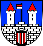
The blazon of the coat of arms reads: In blue a silver castle with a continuous squared battlement wall and two tin towers with red pointed roofs, between them on a stepped battlement on a black mast a red and silver hoisting flag, the gate is covered with a shield divided five times by red and silver.
Town twinning
The city has had a partnership with Le Plessis-Bouchard in Val-d'Oise in France since 1996 . Mutual visits are organized at least three times a year.
Culture and sights
Cultural monuments
theatre
Niederstetten has four theater stages that are used for various performances.
Outdoor games
Since 1991, open-air plays have been held every two years in the Tempele , a romantic extension of the former palace gardens of Holdbergstetten Palace. About 30 amateur actors from the region are involved.
Russia-German Theater
The Russia-German Theater of the actors Viktoria Gräfenstein and David Winkenstern has been located in Niederstetten since 1993 . This theater emerged from the former Deutsches Theater in Alma-Ata , the only German-speaking theater in the former Soviet Union . The theater uses the Oberstetten administrative building as a venue .
Theaterfreunde Herrenzimmern e. V.
The Theaterfreunde has existed in the Herrenzimmern suburb since 2009, and together with the men's choir as the organizer, they put on a three-act act every year in January / February. The Theaterfreunde are a pure amateur drama group that specializes in humorous village theater. On three weekends, a total of between four and six events take place in front of around 100 spectators. The Theaterfreunde Herrenzimmern has been a registered association since 2014.
cult
The Kult is a venue for concerts, cabaret , cabaret events and more. The Niederstetten media library is also located in the building.
Biking and hiking trails
The approximately 180 km long Jakobsweg Main-Taubertal leads through Niederstetten.
Niederstetten lies on the Liebliches Taubertal cycle path - the sporty one .
Museums
The local history museum, the Albert Sammt museum and a hunting museum are located in Niederstetten . There is a wine museum in the Wermutshausen district . To commemorate Eduard Mörike's six-month stay from September 1843 to April 1844 with his friend, Pastor Wilhelm Hartlaub , a Mörike memorial room was set up in 1960 in the Wermutshausen rectory .
Buildings
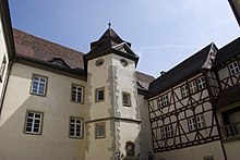
- Holdbergstetten Castle with the Princess House
- The headquarters of BASS GmbH & Co. KG was awarded the Hugo Häring Prize in 2006.
Regular events
- Rossmarkt on Thursday after the second Monday in January.
- Autumn festival on the last weekend of September
- Christmas market (beginning of December)
Old school Niederstetten
The old school Niederstetten is a model creative workshop for young people as well as a conference center . Specialists from various creative professions offer courses in the fields of theater , dance , film and studio technology in the former, completely renovated school building . It is a training and further education facility of the State Amateur Theater Association of Baden-Württemberg and has its own recording studio .
Recreation
A Kneipp facility is located in the Schlosswiesen city and sports park.
Natural monuments
Lenzeichen at Sichertshausen. Oak with supported branches and a BHU of 6.75 m (2015).
Economy and Infrastructure
Niederstetten, in particular the Vorbachzimmer district, is a traditional wine-growing town whose locations belong to the Tauberberg area in the Kocher-Jagst-Tauber area of the Württemberg wine-growing region . There are around 15 hectares of vines in production. There is a wine museum in the Wermutshausen district. The Oberstetten district has marked the beginning of the Württemberg Wine Route since 2016 , the end of which is Kressbronn on Lake Constance.
traffic
Road traffic
The federal highway 290 ( Tauberbischofsheim - Westhausen ) connects Niederstetten to the national road network.
Rail transport
The station Niederstetten is located on the railway line Crailsheim-Königshofen . It has been operated by the Westfrankenbahn since January 1, 2006 and is served every hour. However, since 2004 there have been restrictions in the timetable on weekends. The remaining local public transport (ÖPNV) is served by several bus routes on behalf of the VerkehrsGesellschaft Main-Tauber (VGMT) in the Rhein-Neckar transport association (VRN).
air traffic
With the Niederstetten airfield, Niederstetten has a commercial airfield .
education
The Niederstetten educational center comprises a secondary school , a secondary school and a primary school .
The school farm located in the Pfitzingen district is currently the only state school farm in Germany.
armed forces
The 30th transport helicopter regiment, which belongs to the Rapid Forces division, is based in Niederstetten .
Broadband connection
In 2013, the satellite operator Eutelsat started a model project in the municipality to supply municipalities with internet via satellite . The participants receive Internet access as usual via DSL via the copper wire pair , but the Internet data is fed from orbit from the Ka-Sat satellite into the local DSLAM (DSL access concentrator). The technology was developed by Eutelsat partner Eusanat , formerly known as Satspeed . However, this project was not accepted by the citizens.
In 2016 the go-ahead was given for the nationwide broadband expansion via fiber optics (FFTC, FTTH) in the Main-Tauber district. In the summer of 2017, civil engineering work began on the district of Niederstetten. The first part went into operation in June 2018. The remaining part will take place in July and August 2018. The expansion work will be carried out by Deutsche Telekom. All districts, hamlets and courtyards in Niederstetten have a broadband connection via FTTC or FTTH. In the future, it will be possible to achieve bandwidths of up to 100 Mbit / s in FTTC and even up to 1 Gbit / s in the download with FTTH.
Personalities
literature
- Max Stern: Homeland book of the municipality Niederstetten with the sub-municipalities Ermershausen and Sichertshausen. Knenlein, Niederstetten 1930.
- Walter Krüger (Red.): 650 years of the city of Niederstetten. City of Niederstetten, Niederstetten 1991 (= publications on local history and local history in Württembergisch Franconia. 4).
Web links
- Official website
- On the history of the Jewish community and the synagogue
- The memorable event of the princely town of Niederstetten on the way from the Middle Ages to the modern age, in March 1848 by Fritz Mündlein
- The princess house in Niederstetten.
Individual evidence
- ↑ State Statistical Office Baden-Württemberg - Population by nationality and gender on December 31, 2018 (CSV file) ( help on this ).
- ↑ Main-Tauber-Kreis: Cities and Municipalities , main-tauber-kreis.de, accessed on October 25, 2014.
- ^ The state of Baden-Württemberg. Official description by district and municipality. Volume IV: Stuttgart district, Franconian and East Württemberg regional associations. Kohlhammer, Stuttgart 1980, ISBN 3-17-005708-1 . Pp. 337-343.
- ↑ cf. Hartmut Schäfer: The defunct Dunkenrod settlement, Niederstetten-Adolzhausen community, Main-Tauber district. In: Denkmalpflege in Baden-Württemberg , 6th year 1977, issue 2, pp. 70–75. ( PDF 1.3 MB)
- ↑ a b The official description (including at www.leo-bw.de) assigns the Höllhof farmstead from Niederstetten exclusively to Oberstetten. However, according to the district cut-off on the official LUBW map , the town is divided roughly in half by the district boundary between the two districts of Oberstetten and Wildentierbach. It is unclear whether there is an error in the official description or, conversely, an incorrect representation of the boundary of the official LUBW map.
- ↑ Reinhard Wolf , Ulrike Kreh (ed.): The nature reserves in the Stuttgart administrative region . Thorbecke, Ostfildern 2007.
- ↑ State Statistical Office, area since 1988 according to actual use for Niederstetten.
- ↑ Pierer's Universal Lexicon , zeno.org, accessed on August 8, 2015.
- ^ Federal Statistical Office (ed.): Historical municipality directory for the Federal Republic of Germany. Name, border and key number changes in municipalities, counties and administrative districts from May 27, 1970 to December 31, 1982 . W. Kohlhammer, Stuttgart / Mainz 1983, ISBN 3-17-003263-1 , p. 453 f. and 469 .
- ^ Federal Statistical Office (ed.): Historical municipality directory for the Federal Republic of Germany. Name, border and key number changes in municipalities, counties and administrative districts from May 27, 1970 to December 31, 1982 . W. Kohlhammer, Stuttgart / Mainz 1983, ISBN 3-17-003263-1 .
- ^ Alemannia Judaica: Niederstetten (Main-Tauber-Kreis) Jüdische Geschichte / Prayer Hall / Synagoge , alemannia-judaica.de, accessed on December 5, 2015.
- ^ City of Niederstetten: Main Statute, §3 ; accessed July 5, 2019.
- ^ City of Niederstetten: Main Statute, §14 ; accessed July 5, 2019.
- ^ State Statistical Office of Baden-Württemberg: Municipal elections 2019, City of Niederstetten ; City of Niederstetten: municipal council election 2019 ; FN-Web , May 26, 2019: Result of the 2019 municipal council elections in Niederstetten ; accessed July 5, 2019.
- ↑ Sebastian Mayer: Mayoral election 2018 - City of Niederstetten . ( Niederstetten.de [accessed on February 6, 2018]).
- ↑ Stadt Niederstetten - Theater ( Memento of the original from December 20, 2015 in the Internet Archive ) Info: The archive link was inserted automatically and has not yet been checked. Please check the original and archive link according to the instructions and then remove this notice. , accessed August 15, 2014.
- ^ Website of the Niederstetten Theater Association ( Memento from September 14, 2012 in the web archive archive.today ), accessed on December 18, 2009.
- ↑ Jakobsweg Main-Taubertal (pilgrimage route) - wanderkompass.de. In: wanderkompass.de. Retrieved August 3, 2020 .
- ↑ "The Sportive" - Tourist Association Liebliches Taubertal. In: liebliches-taubertal.de. Retrieved August 3, 2020 .
- ↑ 4th stage of the day - Boxberg to Niederstetten - Liebliches Taubertal tourist office. In: liebliches-taubertal.de. Retrieved August 3, 2020 .
- ^ Website of the Alten Schule Niederstetten , accessed on December 18, 2009.
- ↑ 2010 advanced training program of the State Association of Amateur Theater Baden-Württemberg eV ( Memento of the original from October 21, 2013 in the Internet Archive ) Info: The archive link was automatically inserted and not yet checked. Please check the original and archive link according to the instructions and then remove this notice. , accessed on December 18, 2009, p. 22 (PDF; 696 kB)
- ↑ Lovely Taubertal: Water treading facilities . Online at www.liebliches-taubertal.de. Retrieved August 6, 2018.
- ^ Lenzeichen in the directory of monumental oaks . Retrieved January 10, 2017
- ↑ Bettina Semrau: Now Oberstetten is right at the front. In: fnweb.de. March 31, 2016, accessed April 5, 2016 .
- ↑ Liebliches Taubertal: Flugsport im Liebliches Taubertal , liebliches-taubertal.de, accessed on April 22, 2016.
- ↑ BW-LT-Drucks. 14/2567 ( Memento of the original from October 21, 2013 in the Internet Archive ) Info: The archive link was inserted automatically and has not yet been checked. Please check the original and archive link according to the instructions and then remove this notice. (PDF; 62 kB), Statement by the Ministry of Culture, Youth and Sport on ecological school farms in Baden-Württemberg. P. 2, accessed on December 18, 2009.
- ↑ heise online , September 5, 2013
- ↑ Sebastian Mayer: Broadband expansion Niederstetten - Current status - City of Niederstetten. Retrieved June 6, 2018 (German).


