
Grünsfeld
| coat of arms | Germany map | |
|---|---|---|

|
Coordinates: 49 ° 36 ' N , 9 ° 45' E |
|
| Basic data | ||
| State : | Baden-Württemberg | |
| Administrative region : | Stuttgart | |
| County : | Main-Tauber district | |
| Height : | 210 m above sea level NHN | |
| Area : | 44.72 km 2 | |
| Residents: | 3651 (December 31, 2018) | |
| Population density : | 82 inhabitants per km 2 | |
| Postal code : | 97947 | |
| Area code : | 09346 | |
| License plate : | TBB, MGH | |
| Community key : | 08 1 28 047 | |
| LOCODE : | DE GUU | |
City administration address : |
Hauptstrasse 12 97947 Grünsfeld |
|
| Website : | ||
| Mayor : | Joachim Markert ( CDU ) | |
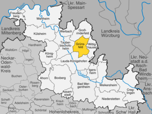
| Location of the city of Grünsfeld in the Main-Tauber district | ||
  |
||

Grünsfeld is a Franconian town in the Main-Tauber district in the north-east of Baden-Württemberg . It owes its name to the Grünbach , a tributary of the Tauber , which flows here with the Wittigbach .
geography
City structure
Grünsfeld consists of the formerly independent communities and today's districts Grünsfeld, Grünsfeldhausen , Krensheim , Kützbrunn , Paimar and Zimmer :
![]() Map with all coordinates of the places in the city of Grünsfeld: OSM
Map with all coordinates of the places in the city of Grünsfeld: OSM
- To Grunfeld the city Grunfeld ( ⊙ ), the hamlet Hof Uhlberg ( ⊙ ) and the living spaces on Fessertal ( ⊙ ) industrial park ob der Tauber (Walter Hill) ( ⊙ ) Riedmühle ( ⊙ ) Rötensteinstraße ( ⊙ ) and Wendel (Englert) -mühle (formerly Neumühle) ( ⊙ ).
- To Grünsfeldhausen the village of Grünsfeldhausen ( ⊙ ).
- To Krensheim the village of Krensheim ( ⊙ ).
- To Kützbrunn the village of Kützbrunn ( ⊙ ).
- At Paimar the village of Paimar ( ⊙ ).
- To Zimmer the village of Zimmer ( ⊙ ).
Protected areas
In the Grünsfeld district there is a 37.3 hectare nature reserve with the Besselberg vineyards .
The FFH area north-east Tauberland lies partly in the Grünsfeld district. There are also 14 protected natural monuments in the city area .
Division of space

According to data from the State Statistical Office , as of 2014.
history
City of Grünsfeld
middle Ages
Grünsfeld was first mentioned in a document in 750. First it belonged to the lordship ofzimmer and then to the lords of Lauda . In 1213 the place fell to the Counts of Rieneck . Around 1320, the municipality was given city rights.
Modern times
From the end of the 15th to the middle of the 17th century, the city belonged to the Landgraviate of Leuchtenberg , then it came to the Duchy of Würzburg , which set up the Grünsfeld District Office in the city . In 1803 Grünsfeld came to the newly formed principality of Leiningen as part of the secularization , where it became the seat of an administrative district. With the dissolution of the principality in 1806 Grünsfeld became Baden . In 1911 the population suffered from a severe flood disaster.
Districts
The five districts were incorporated into Grünsfeld during the regional reform in Baden-Württemberg in the 1970s:
- February 1, 1972: incorporation of Grünsfeldhausen
- January 1, 1973: incorporation of Paimar and Zimmer
- January 1, 1974: Incorporation of Krensheim
- January 1, 1975: incorporation of Kützbrunn
 |
GrünsfeldhausenGrünsfeldhausen was first mentioned in 1322 as Husen . A name change in Grunsvelthusen in 1378 indicates the current name . The place lies on both sides of the Grünbach north of Grünsfeld and essentially shared the history of the core city, as there are roughly the same rule and ownership relationships. The Achatius Chapel in Grünsfeldhausen is a well-known landmark from the 12th century. |
 |
KrensheimKrensheim was first mentioned in a document in 1155. This happened in a document from the Bronnbach monastery . At first the place belonged to a local nobility, but then passed to the lords of Zimmer. The place is located as a clustered village with dense buildings and large courtyards on the Gäu plateau east of the Grünbach valley. Krensheim became known far beyond the borders of the region for its shell limestone, which was used for a long time in the construction of Cologne Cathedral. |
 |
KützbrunnKützbrunn was mentioned in a document even earlier, namely in 1119, when it was donated to the diocese of Würzburg. After the Counts of Rieneck received the place as a fief in the middle of the 13th century, it was given to the Gerlachsheim monastery in the same century , in whose possession it remained until secularization. The place is a densely built-up street village in a spring basin on the hill south of the Wittigbach valley. |
 |
PaimarPaimar, which was first mentioned in a document in 1407, is relatively young. At that time it was called Bunber , later Beumar and Beymar . Little is known about the origins of the village. It always belonged to the district of Grünsfeld and shared its fate. The place is in the upper Grünbachtal. In 1911, the place experienced a severe flood, which caused great damage and claimed eleven lives. |
 |
RoomsThe barons of Zimmer, who were first mentioned in a document in 1155 and ruled not only over their ancestral seat, but also over other places in the region, come from Zimmer. After the rule was united with the rule of Lauda at the end of the 12th century, it fell to the Counts of Rieneck in 1213. The area came to the Duchy of Würzburg via the Counts of Leuchtenberg (see above for details). |
Population development
The population of the city of Grünsfeld (1961 and 1970 excluding the city districts) developed as follows:
| year | population |
|---|---|
| 1961 | 1920 |
| 1970 | 1964 |
| 1991 | 3492 |
| 1995 | 3785 |
| 2005 | 3847 |
| 2010 | 3703 |
| 2015 | 3603 |
Sources: Directory of municipalities and information from the State Statistical Office
religion
Christianity
The Roman Catholic pastoral care unit Grünsfeld-Wittighausen , which is assigned to the deanery Tauberbischofsheim of the Archdiocese of Freiburg , includes the parishes of St. Peter and Paul (Grünsfeld) with the branches of St. Achatius (Grünsfeldhausen) and St. Laurentius (Paimar) , St. Agidius (Krensheim) , St. Margaretha (rooms) , St. Martin (Poppenhausen) , All Saints Church (Unterwittighausen) with the branch St. Agidius (Oberwittighausen) , Hl. Dreifaltigkeit (Kützbrunn) and St. Regiswindis (Vilchband) .
Judaism
A Jewish community in Grünsfeld was established in the Middle Ages and existed with interruptions until the time of National Socialism . Of the Jewish people who were born in Grünsfeld or who lived in the town for a long time, 18 people can be shown to have died during the National Socialist era.
politics
Municipal council
The parish council normally has 14 honorary members who are elected for five years. The number of members can increase through compensatory seats (total 2019: 15 seats). In addition, the mayor acts as the municipal council chairman with voting rights.
The Unechte Teilorteschahl guarantees the districts a fixed number of seats: at least eight councils come from the main village Grünsfeld (with hamlet Hof Uhlberg), from rooms at least two councils, from Grünsfeld-Hausen, Krensheim, Kützbrunn and Paimar at least one councilor each.
The 2019 local elections led to the following result (in brackets: difference to 2014):
| Municipal Council 2019 | ||||
|---|---|---|---|---|
| Party / list | Share of votes | Seats | ||
| Grünsfelder List (GL) | 34.2% (+34.2) | 5 (+5) | ||
| Free citizens' list Grünsfeld (FBL) | 33.0% (−9.3) | 5 (−4) | ||
| CDU / FWV | 32.8% (−24.9) | 5 (−7) | ||
| Turnout: 71.4% (+6.3) | ||||
mayor
Joachim Markert (CDU) has been mayor since 2013.
See also: List of mayors of the city of Grünsfeld
coat of arms
The blazon of the coat of arms reads: "In gold a silver lily, on the collar of which a golden triangular shield with five red bars is leaning against the front, a silver semicircular shield with a blue pole at the back."
Town twinning
Since 1973 Grünsfeld has had a town partnership with Pfreimd , which previously also belonged to the Landgraviate of Leuchtenberg. After the political change in the GDR, a partnership with Großpostwitz in Upper Lusatia was added.
Administrative community
The city of Grünsfeld and the municipality of Wittighausen form the agreed administrative community of Grünsfeld to handle their administrative business together .
Economy and Infrastructure
Water supply
The Taubertal waterworks, built in Dittigheim from 2015 to 2017, supplies around 40,000 people from three cities and three municipalities, as well as industry and commerce in the central Taubertal, with drinking water . The operator is the Central Tauber Water Supply Association , which includes the towns of Grünsfeld, Lauda-Königshofen and Tauberbischofsheim as well as the municipalities of Großrinderfeld , Werbach and Wittighausen .
traffic
Grünsfeld and Zimmer each have a stop on the Frankenbahn ( Stuttgart - Würzburg ). Between Lauda and Würzburg there is an approximate 2-hour cycle with regional trains operated by the Westfrankenbahn .
On the national road 290 ( Tauberbischofsheim - Aalen ) green field at the Highway 81 tethered.
education
With the Dorothea von Rieneck School, the city has a primary and technical secondary school, which is a regional LRS and dyscalculia location .
Culture and sights
Buildings


The town hall in the old town is a Franconian secular building from 1579.
- The city church of St. Peter and Paul from the 14th and 15th centuries is visible from all sides . Century with a 75 m high tower.
- The Grünsfelder Kreuzweg on the station path
- Office building , today a local museum
- In the Grünsfeldhausen district there is one of the few remaining Romanesque octagonal churches in southern Germany, the St. Achatius Chapel, built around 1220 . Since it was built, the bottom of the valley has increased by approx. 3 m in several stages. From 1903 to 1905 the original entrance was exposed again.
- The house at Abt-Wundert-Straße 4 is an impressive example of a Franconian half-timbered building. The courtyard was built in 1692. With its historic fountain in the garden, it shows the original, typically Franconian three-sided courtyard with a closing gate and round arch (date 1713).
- Transmission tower transmitter Wittigbachtal
- The Trinity Church is located in the Kützbrunn district , a baroque hall building from 1717 with a polygonal closure from 1735.
- To the south of the district of Krensheim there is an overhead line mast under the legs of which a dirt road leads through


See also: List of cultural monuments in Grünsfeld
Biking and hiking trails
The approximately 180 km long Jakobsweg Main-Taubertal leads through Grünsfeld and Grünsfeldhausen. The Grünbachtal cycle path leads from Grünsfeld in the direction of Grünsfeldhausen and in the direction of Gerlachsheim, where there is a connection to the Taubertal cycle path . The Wittigbachtal cycle path leads from Grünsfeld via Zimmer to Unterwittighausen.
Recreation
A Kneipp facility was built in 2016 at the Grünsfelder Stadtbrunnen.
Personalities
societies
- FC Grünsfeld (soccer, gymnastics)
- Alpha Fighters (Martial Arts)
- TC Grünsfeld (tennis)
literature
- Elmar Weiß: History of the City of Grünsfeld . 2nd Edition. City administration Grünsfeld, Grünsfeld 1992.
- Grünsfeld . In: Topographia Franconiae ( Matthäus Merian ) [ Wikisource ]
Web links
Individual evidence
- ↑ State Statistical Office Baden-Württemberg - Population by nationality and gender on December 31, 2018 (CSV file) ( help on this ).
- ↑ Cities and municipalities . Main-Tauber district; Retrieved October 25, 2014
- ^ The state of Baden-Württemberg. Official description by district and municipality. Volume IV: Administrative region of Stuttgart, regional associations of Franconia and East Wuerttemberg . Kohlhammer, Stuttgart 1980, ISBN 3-17-005708-1 , pp. 319-322
- ↑ Reinhard Wolf , Ulrike Kreh (ed.): The nature reserves in the Stuttgart administrative region . Thorbecke, Ostfildern 2007
- ↑ State Statistical Office, area since 1988 according to actual use for Grünsfeld
- ↑ a b City of Grünsfeld: The history of the city of Grünsfeld . gruensfeld.de; accessed on February 23, 2018.
- ^ Federal Statistical Office (ed.): Historical municipality directory for the Federal Republic of Germany. Name, border and key number changes in municipalities, counties and administrative districts from May 27, 1970 to December 31, 1982 . W. Kohlhammer, Stuttgart / Mainz 1983, ISBN 3-17-003263-1 , p. 480 .
- ^ Federal Statistical Office (ed.): Historical municipality directory for the Federal Republic of Germany. Name, border and key number changes in municipalities, counties and administrative districts from May 27, 1970 to December 31, 1982 . W. Kohlhammer, Stuttgart / Mainz 1983, ISBN 3-17-003263-1 , p. 481 .
- ^ Federal Statistical Office (ed.): Historical municipality directory for the Federal Republic of Germany. Name, border and key number changes in municipalities, counties and administrative districts from May 27, 1970 to December 31, 1982 . W. Kohlhammer, Stuttgart / Mainz 1983, ISBN 3-17-003263-1 , p. 469 .
- ^ Federal Statistical Office (ed.): Historical municipality directory for the Federal Republic of Germany. Name, border and key number changes in municipalities, counties and administrative districts from May 27, 1970 to December 31, 1982 . W. Kohlhammer, Stuttgart / Mainz 1983, ISBN 3-17-003263-1 , p. 470 .
- ^ Federal Statistical Office (ed.): Historical municipality directory for the Federal Republic of Germany. Name, border and key number changes in municipalities, counties and administrative districts from May 27, 1970 to December 31, 1982 . W. Kohlhammer, Stuttgart / Mainz 1983, ISBN 3-17-003263-1 .
- ↑ Catholic Dean's Office Tauberbischofsheim: Pastoral care unit Grünsfeld-Wittighausen ( page no longer available , search in web archives ) Info: The link was automatically marked as defective. Please check the link according to the instructions and then remove this notice. . Online at www.kath-dekanat-tbb.de. Retrieved October 25, 2016.
- ↑ a b Grünsfeld (Main-Tauber district) Jewish history / prayer room / synagogue . Alemannia Judaica; accessed on June 16, 2015.
- ↑ Information based on the lists from Yad Vashem, Jerusalem.
- ↑ Information from the memorial book - Victims of the persecution of Jews under the Nazi tyranny in Germany 1933-1945 .
- ↑ Matthias Ernst: In future 14 councilors in the Grünsfeld council . Main-Post , December 3, 2015; accessed July 3, 2019.
- ↑ State Statistical Office Baden-Württemberg: Municipal elections 2019, City of Grünsfeld . ; FN-Web , May 26, 2019: Result of the 2019 municipal council election in Grünsfeld . ; accessed July 3, 2019.
- ^ Diana Seufert: Joachim Markert becomes the new town hall chief. fnweb.de , March 11, 2013, accessed April 27, 2013 .
- ↑ Home . Zweckverband Wasserversorgung Mittlere Tauber; accessed on February 23, 2018.
- ↑ From 2017 drinking water from Dittigheim . Main-Post, October 28, 2016; accessed on February 23, 2018.
- ↑ Jakobsweg Main-Taubertal (pilgrimage route) - wanderkompass.de. In: wanderkompass.de. Retrieved August 3, 2020 .
- ^ Grünsfeld / Großrinderfeld / Wittighausen / Grünsfeld municipal council. Kneipp facility, benches and an open bookcase planned / Multi-generation space for the Grasanger / New life around the city fountain . Fränkische Nachrichten , March 19, 2016; accessed on August 6, 2018.
- ↑ Grünsfelder Stadtbrunnen receives Kneipp facility . Blick Lokal, September 2, 2016; accessed on August 6, 2018.

Maple | Assamstadt | Bad Mergentheim | Boxberg | Creglingen | Freudenberg | Large cattle field | Grünsfeld | Igersheim | Koenigheim | Külsheim | Lauda-Koenigshofen | Niederstetten | Tauberbischofsheim | Weikersheim | Werbach | Wertheim | Wittighausen
Grünsfeld with Hof Uhlberg | Grünsfeldhausen | Krensheim | Kützbrunn | Paimar | Rooms