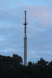
Wittigbachtal transmitter
|
Wittigbachtal transmitter
|
||
|---|---|---|
| Basic data | ||
| Place: | Grünsfeld | |
| Country: | Baden-Württemberg | |
| Country: | Germany | |
| Altitude : | 290 m above sea level NN | |
| Coordinates: 49 ° 36 ′ 4.7 " N , 9 ° 44 ′ 41.4" E | ||
| Use: | Broadcasting station | |
| Accessibility: | Transmission tower not open to the public | |
| Owner : | Südwestrundfunk | |
| Tower data | ||
| Client : | Süddeutscher Rundfunk | |
| Data on the transmission system | ||
| Waveband : | FM transmitter | |
| Radio : | VHF broadcasting | |
| Position map | ||
|
|
||
The Wittigbachtal transmitter is a SWR transmitter south of Grünsfeld . It uses a 67 meter high reinforced concrete tower, which was completed in 1971, as the antenna carrier.
Frequencies and Programs
Analog radio (VHF)
|
Frequency (MHz) |
program | RDS PS | RDS PI | Regionalization |
ERP (kW) |
Antenna pattern round (ND) / directional (D) |
Polarization horizontal (H) / vertical (V) / circular (Z) |
|---|---|---|---|---|---|---|---|
| 90.4 | SWR4 Baden-Württemberg | SWR4_HN_ | DD04 | Heilbronn | 0.05 | ND | H |
| 92.4 | SWR1 Baden-Württemberg | SWR1_BW_ | D301 | - | 0.05 | ND | H |
| 94.1 | SWR3 | __SWR3__ | D3A3 | - | 0.05 | ND | H |
Analog television (PAL)
Until the switch to DVB-T, the transmitter location was still used for analog television:
| channel |
Frequency (MHz) |
program |
ERP (kW) |
Transmission diagram round (ND) / directional (D) |
Polarization horizontal (H) / vertical (V) |
|---|---|---|---|---|---|
| 26th | 511.25 | ZDF | 0.025 | D. | H |
| 46 | 671.25 | SWR television Baden-Württemberg | 0.025 | D. | H |
| 49 | 695.25 | The First (SWR) | 0.05 | D. | H |
Web links
Commons : Sender Wittigbachtal - Collection of images, videos and audio files


