
Wildentierbach (Niederstetten)
|
Wild animal stream
City of Niederstetten
|
|
|---|---|
 |
|
| Height : | 433 m |
| Incorporation : | February 1, 1972 |
| Postal code : | 97996 |
| Area code : | 07932 |
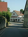
 Wild animal stream, seen from the east
|
|
Wildentierbach , called Derbe in the local dialect , is a district of Niederstetten in the Main-Tauber district in Baden-Württemberg .
geography
Geographical location
The village, which gives its name to the district of the small town, is located in the Hohenloher Ebene natural area about 4.5 km east of the city center of Niederstetten in the valley of the Wildentierbach , which is already moving southwards and flows into the Reutal reservoir south of the village ; its runoff reaches the Vorbach via the Reutalbach . About one kilometer west of the village, at the height and mostly already on the Niederstetten suburb, the Niederstetten military airfield is located near a Bundeswehr barracks.
The Wildentierbach district includes some east to south-east settlements: the hamlets of Hachtel, Heimberg and Wolkersfelden, the Höllhof and Schönhof farms and the Landturm residential area.
Protected areas
The water protection area Reutalquelle, Wildentierbach with the WSG no. 128071 covers a protected area of 1,296.06 hectares. This makes it one of the larger water protection areas in the Main-Tauber district . The nature reserve Oberrimbacher Erdfälle with an area of 71.2 hectares is located in the districts of Oberrimbach , Wildentierbach and Spielbach .
history
The place belonged to the Lords of Hohenlohe-Brauneck in the 13th century.
The lords of Tierbach, attested from the 12th to the 14th century, presumably sat as their feudal and servants at Wildentierbach Castle, which was destroyed by Melchior von Rosenberg zu Haltbergstetten in 1509 . In the 15th century Rothenburg gradually acquired the place, in 1525 obtained from the Margraves of Ansbach the magistrate rights from the Braunecks and finally also secured the decisive influence on the occupation of the parish, which belonged to the Neumünster Abbey in Würzburg. Wildentierbach within the Rothenburg Landwehr , was reinforced with a fence, ditch and 3 gate towers and had a fortified churchyard, the lining wall of which has been preserved. On February 1, 1972, Wildentierbach was incorporated into Niederstetten.
Culture and sights
Cultural monuments
Wildentierbach fortified church
The old Protestant fortified church with a well-preserved detention cell is remarkable . The Romanesque church was first mentioned in 999 and can also be visited by appointment. There is an entrance tower on the defensive wall.

Painting by Wildentierbach


Other architectural monuments
- Village arrest in the fortified tower: A cell from the 19th century has been preserved in the fortified church tower. This was opened to the public as a museum in 1985.
- Rectory: half-timbered building.
- Town hall: It is a solid building with a half-hipped roof and a simple structure with a round cellar arch. The house dates from the beginning of the 19th century.
Wildentierbach rectory, Dorfstrasse
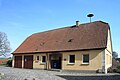
Wildentierbach town hall


Village and court linden tree
The village and court linden tree in Wildentierbach ( natural monument No. 81280820014) was measured in 2020 with a tree circumference of 5.44 m. The height of the tree is 12 m and the age about 400 to 500 years.
Biking and hiking trails
Wildentierbach is located on the Liebliches Taubertal cycle path - the sporty one .
societies
- Choral society "Liederkranz 1886" Wildentierbach
- Country women wild animal stream
- Voluntary fire brigade Dept. Wildentierbach
- Youth club "Freizeit eV Derbe 1985"
Business
- Burkard earthworks
- Friedrich Fischer agricultural technology
- Siegmund Bender cider & distillery
- Werner Egner Flaschnerei
Individual evidence
- ↑ Wolf-Dieter Sick : Geographical land survey: The natural space units on sheet 162 Rothenburg o. D. Deaf. Federal Institute for Regional Studies, Bad Godesberg 1962. → Online map (PDF; 4.7 MB)
- ^ Federal Statistical Office (ed.): Historical municipality directory for the Federal Republic of Germany. Name, border and key number changes in municipalities, counties and administrative districts from May 27, 1970 to December 31, 1982 . W. Kohlhammer, Stuttgart / Mainz 1983, ISBN 3-17-003263-1 , p. 453 .
- ↑ Wehrkirche Wildentierbach 42 42-1 Niederstetten - detail page - LEO-BW. In: leo-bw.de. Retrieved August 23, 2020 .
- ↑ Village arrest in the defense tower - detail page - LEO-BW. In: leo-bw.de. Retrieved August 23, 2020 .
- ↑ Town hall Wildentierbach 31 Niederstetten - detail page - LEO-BW. In: leo-bw.de. Retrieved August 23, 2020 .
- ↑ "Dorflinde in Wildentierbach" in the tree register at www.baumkunde.de
- ↑ "The Sportive" - Tourist Association Liebliches Taubertal. In: liebliches-taubertal.de. Retrieved August 3, 2020 .
- ↑ 5th day stage - Boxberg to Niederstetten - Liebliches Taubertal tourist office. In: liebliches-taubertal.de. Retrieved August 3, 2020 .
Web links
- Map of the Wildentierbach sub-district marking on: State Institute for the Environment Baden-Württemberg (LUBW) ( information )
- Map of the village of Wildentierbach and its surroundings on: Geoportal Baden-Württemberg ( information )
- Topographical Atlas of the Kingdom of Württemberg - Sheet 3 Niederstetten from 1843 with (then) Wildenthierbach and the associated places