Rothenburg Landhege
The Rothenburger Landhege , also called Rothenburger Heg or Rothenburger Landwehr , is a 62 km long Landwehr that encloses an area of around 350 km² around Rothenburg ob der Tauber . Its construction was decided by the Rothenburg city council in 1420 and completed by 1480. It moved from Steinach near Rothenburg ob der Tauber in the northeast in a western arc via Lichtel in the northwest, Rohrturm in the southwest to Wettringen in the southeast. The eastern border of the Rothenburg territory along the western slope of the Frankenhöhe remained largely unpaved. The Landwehr villages of Hachtel, Oberstetten and Wildentierbach to the west were left out. The Landhege protected the territory with around 163 villages and 40 castles that had been acquired by the city in the previous decades from the local aristocrats from looting. It was about 20 meters wide and usually consisted of three walls and two trenches. It was planted with impenetrable hedges. The guardians were responsible for their care .
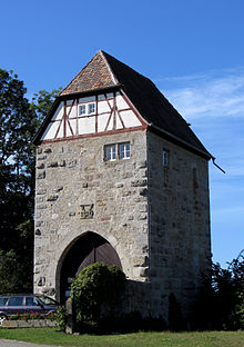
The important culverts were secured by a total of nine land towers, on which customs were also levied, from northeast to northwest to southwest: near Steinach, Seemühle , Habelsee, Hinterpfeinach, Reichardsroth , Großharbach , Lichtel (Lichteler Landturm), Heimberg , Funkstatt and Hilgartshausen (tubular tower ). The Hegereiter lived in them . In an emergency, the Hege was defended by the armed population. The Lichteler Landturm , used by the Swabian Alb Association , and the Großharbacher on the bridge in the village are still well preserved today . From the pipe tower in the homestead of the same name directly on the road from Hilgartshausen to Musdorf there is still a tower stump roofed over to form a barn with a coat of arms on the west and east sides. The tower existed until 1945, was badly damaged by tank shells in firefights at the end of the war and collapsed in 1946.
Napoléon Bonaparte had the land park lifted in 1802 and partially leveled. The towers were sold. However, the Heg can still be seen over long stretches of the landscape, especially in wooded areas. In some places long, narrow strips of forest show the former course from afar, for example between Blaufelden -Engelhardshausen and Rot am See -Herbertshausen. In the course of the fall of the Holy Roman Empire , Rothenburg came to the Bavarian part of Franconia , but the western part of the imperial city territory to Württemberg . That is why the greater part of the state enclosure that surrounded it is now in Baden-Württemberg .
Landscape protection area
The remains of the Landhege in the Schwäbisch Hall district are designated as a landscape protection area. A strip of terrain that is only 50 to 80 meters wide is protected and extends over around 15 kilometers in 13 areas. The LSG was identified under the name Rothenburger Landhege by ordinance of the Schwäbisch Hall District Office of April 16, 1982, it has the protected area number 1.27.015 and is 62.0 hectares in size. The main protection purpose is the preservation of the still recognizable remains of the Rothenburg Landhege, which is to be safeguarded as a culturally and historically significant document in its peculiarity and traditional form as a valuable part of the landscape. In addition, the conservation of the land enclosure should be achieved as a windbreak hedge, as a bird protection wood, as a habitat for threatened animal and plant species and as a retreat and cover for small game.
literature
- Heinrich Henn, Hans Mattern : The Rothenburger Landhege, a threatened part of the landscape in northeast Württemberg. In: Publications of the State Agency for Nature Conservation and Landscape Management Baden-Württemberg, Volume 37, pp. 243-271 Ludwigsburg, 1967. Additions to this: ibid. Issue 38 (1970) pp. 149-157.
- Hans Mattern: The Rothenburger Landhege - reunion after two decades . In: Die Linde 70 (1988) pp. 65-68, 73-88, 92-95. Rothenburg odT
- Alois Schneider: Boundaries of late medieval urban territorial rulers using the example of the Schwäbisch Haller and the Rothenburger Landhege. In: Gabriele Isenberg, Barbara Scholckmann (eds.): The fortification of the medieval city (Städtforschung A / 45), Cologne 1997, pp. 111–135
- Herbert Woltering: The imperial city of Rothenburg ob der Tauber and its rule over the Landwehr. Part 1–2. Rothenburg odT 1965–1971
- Edmund Zöller: Criss- cross through the Rothenburger Landwehr , fold-out brochure, apparently self-published, then Ansbach, undated.
Web links
- Images of the country enclosure on the Brettenfeld website between Herbertshausen and Breitloh near Engelhardshausen
- The Rothenburger Landhege on the website of the Swabian Alb Association
- An imperial city hides itself ( Memento from July 1, 2009 in the Internet Archive ). In: Franconian news
- The Rothenburger Landhege at 'Historical Borders'


