
Wettringen (Middle Franconia)
| coat of arms | Germany map | |
|---|---|---|

|
Coordinates: 49 ° 15 ' N , 10 ° 9' E |
|
| Basic data | ||
| State : | Bavaria | |
| Administrative region : | Middle Franconia | |
| County : | Ansbach | |
| Management Community : | Schillingsfürst | |
| Height : | 423 m above sea level NHN | |
| Area : | 21.42 km 2 | |
| Residents: | 1007 (Dec. 31, 2019) | |
| Population density : | 47 inhabitants per km 2 | |
| Postal code : | 91631 | |
| Area code : | 09869 | |
| License plate : | AN , DKB, FEU, ROT | |
| Community key : | 09 5 71 222 | |
| Community structure: | 7 parts of the community | |
| Address of the municipal administration: |
At the church 3 91631 Wettringen |
|
| Website : | ||
| Mayor : | Karl Augustin sen. ( Voter groups ) | |
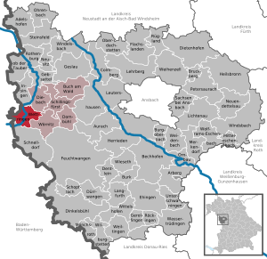
| Location of the municipality Wettringen in the district of Ansbach | ||
  |
||

Wettringen is a municipality in the Ansbach district in Middle Franconia . The community is a member of the Schillingsfürst administrative community .
geography
Geographical location

The community is located about 30 kilometers west of Ansbach in the Frankenhöhe Nature Park .
Neighboring communities
Neighboring municipalities are (starting from the north and clockwise):
- The stream
- Wörnitz
- Schnelldorf
- Rot am See (Baden-Württemberg)
- Insingen
Community structure
The municipality has seven officially named municipality parts (the type of settlement is given in brackets ):
- Grüb ( village )
- Obergailnau ( hamlet )
- Reichenbach (hamlet)
- Seemühle ( wasteland )
- Taubermühle (wasteland)
- Untergailnau ( Kirchdorf )
- Wettringen ( parish village )
history
The place is first mentioned in a document in 1100 as "Wateringun". The place name is based on the personal name Watheri, which was derived from the affiliation suffix -ingen . The place name means With the people of Watheri .
In 1406 the imperial city of Rothenburg bought Wettringen and the neighboring towns from the Hohenlohe house . In 1637 the place burned down as much as possible as a result of the 30-year war . Also in 1688 the place was largely destroyed by French murder burners. In 1804 there were 65 community rights in the village, all of which were subject to the imperial city of Rothenburg.
With the municipal edict (early 19th century), the Wettringen tax district was formed, to which the places Gailroth , Leitsweiler , Löffelmühle, Reichenbach , Seemühle , Taubermühle and Thomasmühle belonged. A little later , the wettringen rural community was formed with Grüb , Löffelmühle, Reichenbach, Seemühle, Taubermühle and Thomasmühle . It was subordinate to the regional court of Rothenburg in administration and jurisdiction . In 1961 the municipality had an area of 13.616 km².
Incorporations
On May 1, 1978, the previously independent community of Gailnau was incorporated.
Population development
In the period from 1988 to 2018, the population increased from 892 to 1006 by 114 inhabitants or by 12.8%.
Wettringen community
| year | 1818 | 1840 | 1852 | 1861 | 1867 | 1871 | 1875 | 1880 | 1885 | 1890 | 1895 | 1900 | 1905 | 1910 | 1919 | 1925 | 1933 | 1939 | 1946 | 1950 | 1961 | 1970 | 1987 | 2005 | 2011 | 2017 |
|---|---|---|---|---|---|---|---|---|---|---|---|---|---|---|---|---|---|---|---|---|---|---|---|---|---|---|
| Residents | 552 | 667 | 703 | 701 | 708 | 695 | 704 | 751 | 778 | 786 | 725 | 688 | 707 | 708 | 731 | 722 | 692 | 632 | 913 | 833 | 613 | 611 | 886 | 960 | 952 | 1022 |
| Houses | 117 | 130 | 140 | 139 | 142 | 145 | 139 | 141 | 237 | 297 | 310 | |||||||||||||||
| source |
Part of the municipality Wettringen
| year | 1818 | 1840 | 1861 | 1871 | 1885 | 1900 | 1925 | 1950 | 1961 | 1970 | 1987 |
|---|---|---|---|---|---|---|---|---|---|---|---|
| Residents | 457 | 553 | 577 | 572 | 657 | 586 | 611 | 717 | 517 | 532 | 546 |
| Houses | 96 | 109 | 117 | 120 | 125 | 118 | 121 | 146 | |||
| source |
politics
Municipal council
After the last election in 2014, the municipal council has eight members. The choice brought the following result:
| Wettringen voter group | 5 seats | ||
| Gailnau voter group | 3 seats |
Another member and chairman of the municipal council is the mayor.
mayor
In the mayoral election in March 2014, Karl Augustin received 83.3% of the vote. He has been in office since May 2008.
badges and flags
The municipality of Wettringen has had its own coat of arms since 1986.
|
|
Blazon : "In silver over a green three-mountain, which is covered with a silver wave bar, a floating red castle with tin towers, with a vertical black key at the front and a black sword at the back."
Red-white-green municipal flag |
| The reason for the coat of arms: The Dreiberg represents the location of the place at the foot of the Frankenhöhe , the silver wave bar represents the Tauber , which rises in the municipality. Key and sword are the attributes of Saints Peter and Paul and point to the church in Wettringen, which is consecrated to them. The red castle is taken from the coat of arms of the imperial city of Rothenburg , which was wealthy in the place from 1379 to 1803. |
Architectural monuments

Established businesses
- Manufacturing engineering Wettringen GmbH
traffic
The state road 2247 / state road 2247 leads past Leitsweiler to Michelbach an der Lücke or to state road 2419 west of Untergailnau . The district road AN 16 leads to Grüb . Municipal roads lead to Untergailnau, Reichenbach and Kleinansbach to Kreisstraße 2513 .
particularities
- During the 1970s, the municipality of Wettringen and the village of Weikersholz near Rot am See in Baden-Württemberg competed for the source of the Tauber . Today the well in Weikersholz is officially regarded as the place of the source.
- Annual events are the cattle market in March, the parish fair in July and the fountain festival in June.
- There is a swimming pond just outside the village. It was opened in 1970 as part of the land consolidation.
literature
- Johann Kaspar Bundschuh : Wettringen . In: Geographical Statistical-Topographical Lexicon of Franconia . tape 6 : V-Z . Verlag der Stettinische Buchhandlung, Ulm 1804, DNB 790364328 , OCLC 833753116 , Sp. 205-207 ( digitized version ).
- Hans Karlmann Ramisch: District of Rothenburg ob der Tauber (= Bavarian art monuments . Volume 25 ). Deutscher Kunstverlag, Munich 1967, DNB 457879254 , p. 121-123 .
- Wolf-Armin von Reitzenstein : Lexicon of Franconian place names. Origin and meaning . Upper Franconia, Middle Franconia, Lower Franconia. CH Beck, Munich 2009, ISBN 978-3-406-59131-0 , p. 241 .
Web links
- Map of the municipality of Wettringen on the BayernAtlas
- Competition in the Topographia Franconiae of the University of Würzburg , accessed on September 18, 2019.
- Wettringen (Middle Franconia): Official statistics of the LfStat
Individual evidence
- ↑ "Data 2" sheet, Statistical Report A1200C 202041 Population of the municipalities, districts and administrative districts 1st quarter 2020 (population based on the 2011 census) ( help ).
- ^ Community Wettringen in the local database of the Bavarian State Library Online . Bayerische Staatsbibliothek, accessed on September 18, 2019.
- ↑ W.-A. v. Reitzenstein, p. 241.
- ↑ JK Bundschuh, Vol. 6, Col. 205ff.
- ^ Address and statistical manual for the Rezatkreis in the Kingdom of Baiern . Buchdruckerei Chancellery, Ansbach 1820, p. 67 ( digitized version ).
- ↑ a b c Bavarian State Statistical Office (ed.): Official city directory for Bavaria, territorial status on October 1, 1964 with statistical information from the 1961 census . Issue 260 of the articles on Bavaria's statistics. Munich 1964, DNB 453660959 , Section II, Sp. 817-818 ( digitized version ).
- ^ Federal Statistical Office (ed.): Historical municipality directory for the Federal Republic of Germany. Name, border and key number changes in municipalities, counties and administrative districts from May 27, 1970 to December 31, 1982 . W. Kohlhammer, Stuttgart / Mainz 1983, ISBN 3-17-003263-1 , p. 707 .
- ↑ a b Only inhabited houses are given. In 1818 these were designated as fireplaces , in 1840 as houses , and from 1871 to 2015 as residential buildings.
- ↑ a b Alphabetical index of all the localities contained in the Rezatkreise according to its constitution by the newest organization: with indication of a. the tax districts, b. Judicial Districts, c. Rent offices in which they are located, then several other statistical notes . Ansbach 1818, p. 102 ( digitized version ). For the municipality of Wettringen plus the residents and buildings of Grüb (p. 33), Reichenbach (p. 74), Seemühle (p. 85) and Taubermühle (p. 91).
- ^ A b Eduard Vetter (Ed.): Statistical handbook and address book of Middle Franconia in the Kingdom of Bavaria . Self-published, Ansbach 1846, p. 227 ( digitized version ). According to the historical municipality register , the municipality had 668 inhabitants.
- ^ A b c d e f g h i Bavarian State Statistical Office (Hrsg.): Historical municipality directory: The population of the municipalities of Bavaria from 1840 to 1952 (= contributions to Statistics Bavaria . Issue 192). Munich 1954, DNB 451478568 , p. 182 , urn : nbn: de: bvb: 12-bsb00066439-3 ( digitized version ).
- ↑ a b Joseph Heyberger, Chr. Schmitt, v. Wachter: Topographical-statistical manual of the Kingdom of Bavaria with an alphabetical local dictionary . In: K. Bayer. Statistical Bureau (Ed.): Bavaria. Regional and folklore of the Kingdom of Bavaria . tape 5 . Literary and artistic establishment of the JG Cotta'schen Buchhandlung, Munich 1867, Sp. 1076 , urn : nbn: de: bvb: 12-bsb10374496-4 ( digitized version ).
- ↑ Kgl. Statistisches Bureau (Ed.): Directory of the municipalities of the Kingdom of Bavaria according to the status of the population in December 1867 . XXI. Issue of the contributions to the statistics of the Kingdom of Bavaria. Ackermann, Munich 1869, p. 172 ( digitized version ).
- ↑ a b Kgl. Statistical Bureau (ed.): Complete list of localities of the Kingdom of Bavaria. According to districts, administrative districts, court districts and municipalities, including parish, school and post office affiliation ... with an alphabetical general register containing the population according to the results of the census of December 1, 1875 . Adolf Ackermann, Munich 1877, 2nd section (population figures from 1871, cattle figures from 1873), Sp. 1243–1244 , urn : nbn: de: bvb: 12-bsb00052489-4 ( digitized version ).
- ↑ K. Bayer. Statistical Bureau (ed.): Community directory for the Kingdom of Bavaria. Manufactured due to the new organization of government districts, district offices and judicial districts. Addendum to issue 36 of the articles on Bavaria's statistics. Munich 1879, p. 68 ( digitized version ).
- ↑ K. Bayer. Statistical Bureau (ed.): Community directory for the Kingdom of Bavaria. Results of the census of December 1, 1880. Issue 35 of the articles on Bavaria's statistics. Munich 1882, p. 195 ( digitized version ).
- ↑ a b K. Bayer. Statistical Bureau (Ed.): Localities directory of the Kingdom of Bavaria. According to government districts, administrative districts, ... then with an alphabetical register of locations, including the property and the responsible administrative district for each location. LIV. Issue of the contributions to the statistics of the Kingdom of Bavaria. Munich 1888, Section III, Sp. 1178-1179 ( digitized version ).
- ↑ a b K. Bayer. Statistical Bureau (Ed.): Directory of localities of the Kingdom of Bavaria, with alphabetical register of places . LXV. Issue of the contributions to the statistics of the Kingdom of Bavaria. Munich 1904, Section II, Sp. 1250 ( digitized version ).
- ↑ a b Bavarian State Statistical Office (ed.): Localities directory for the Free State of Bavaria according to the census of June 16, 1925 and the territorial status of January 1, 1928 . Issue 109 of the articles on Bavaria's statistics. Munich 1928, Section II, Sp. 1288 ( digitized version ).
- ↑ a b Bavarian State Statistical Office (ed.): Official place directory for Bavaria - edited on the basis of the census of September 13, 1950 . Issue 169 of the articles on Bavaria's statistics. Munich 1952, DNB 453660975 , Section II, Sp. 1114–1115 ( digitized version ).
- ↑ a b Bavarian State Statistical Office (Hrsg.): Official local directory for Bavaria . Issue 335 of the articles on Bavaria's statistics. Munich 1973, DNB 740801384 , p. 172 ( digitized version ).
- ↑ a b Bavarian State Office for Statistics and Data Processing (Ed.): Official local directory for Bavaria, territorial status: May 25, 1987 . Issue 450 of the articles on Bavaria's statistics. Munich November 1991, DNB 94240937X , p. 332 ( digitized version ).
- ↑ a b c Wettringen (Middle Franconia): Official statistics of the LfStat
- ^ Entry on the coat of arms of Wettringen (Middle Franconia) in the database of the House of Bavarian History
- ↑ Wettringen. In: Kommunalflaggen.eu. Retrieved March 2, 2020 .

Adelshofen | Arberg | Aurach | Bechhofen | Bruckberg | Book at the forest | Burgoberbach | Burk | Colmberg | Dentlein am Forst | Diebach | Dietenhofen | Dinkelsbühl | Dombühl | Dürrwangen | Ehingen | Feuchtwangen | Flachslanden | Gebsattel | Gerolfingen | Geslau | Heilsbronn | Herrieden | Insingen | Langfurth | Lehrberg | Leutershausen | Lichtenau | Merkendorf | Mitteleschenbach | Mönchsroth | Neuendettelsau | Neusitz | Oberdachstetten | Ohrbach | Ornbau | Petersaurach | Röckingen | Rothenburg ob der Tauber | Rügland | Saxony near Ansbach | Schillingsfürst | Schnelldorf | Schopfloch | Steinsfeld | Unterschwaningen | Wassertrüdingen | Weidenbach | Weihenzell | Weiltingen | Wettringen | Wieseth | Wilburgstetten | Windelsbach | Windsbach | Wittelshofen | Wolframs-Eschenbach | Wörnitz
Unregulated areas:
Lower Forest