
Adelshofen (Middle Franconia)
| coat of arms | Germany map | |
|---|---|---|
.svg)
|
Coordinates: 49 ° 26 ' N , 10 ° 10' E |
|
| Basic data | ||
| State : | Bavaria | |
| Administrative region : | Middle Franconia | |
| County : | Ansbach | |
| Management Community : | Rothenburg ob der Tauber | |
| Height : | 429 m above sea level NHN | |
| Area : | 27.18 km 2 | |
| Residents: | 931 (Dec. 31, 2019) | |
| Population density : | 34 inhabitants per km 2 | |
| Postal code : | 91587 | |
| Area code : | 09865 | |
| License plate : | AN , DKB, FEU, ROT | |
| Community key : | 09 5 71 111 | |
| Market structure: | 10 districts | |
| Association administration address: | Laiblestraße 31 91541 Rothenburg ob der Tauber |
|
| Website : | ||
| Mayor : | Johannes Schneider, First Mayor ( Voting Community Adelshofen / Großharbach / Neustett / Tauberscheckenbach / Tauberzell ) | |
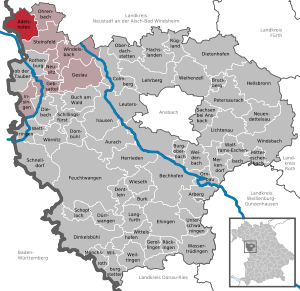
| Location of the Adelshofen market (Middle Franconia) in the Ansbach district | ||
  |
||

.jpg)
Adelshofen is a municipality and a place in the district of Ansbach in Middle Franconia . It is a member of the Rothenburg ob der Tauber administrative community .
geography
The community is located in the Taubertal in the West Central Franconia region , about 6.5 km north of Rothenburg ob der Tauber .
Community structure
There are ten common parts :
|
|
The Karren and Salznersmühle are part of the Tauberscheckenbach district.
Neighboring communities
Neighboring communities are (starting in the north clockwise) Uffenheim , Ohrbach , Steinsfeld , Creglingen and Simmershofen .
history
Until the church is planted
Adelshofen is mentioned for the first time in 1333 as "Otylshouen". The place name is derived from the personal name Othil .
In 1383, the Free Imperial City of Rothenburg ob der Tauber acquired large parts of today's municipal area and secured it in 1430 with ramparts and ditches. From 1500 Adelshofen was part of the Franconian Empire . Since the Reichsdeputationshauptschluss of 1803, the place, like large parts of Franconia , belongs to Bavaria (see also history of Franconia ).
With the community edict (early 19th century), the tax district Adelshofen was formed, to which the places Adelshofen, Gickelhausen , Großharbach , Haardt and Ruckertshofen belonged. A little later the rural community of Adelshofen was formed with the places Adelshofen, Gickelhausen, Haardt and Ruckertshofen. In administration and jurisdiction it was subordinate to the Regional Court of Rothenburg . Before the territorial reform of the 1970s, the municipality had an area of 10,065 km².
Incorporations
On July 1, 1972, the communities Großharbach, Tauberscheckenbach and Tauberzell were incorporated into Adelshofen as part of the regional reform . Neustett was added on May 1, 1978.
Population development
In the period from 1988 to 2018, the population fell from 970 to 955 by 15 inhabitants or 1.6%.
Adelshofen community
| year | 1818 | 1840 | 1852 | 1861 | 1867 | 1871 | 1875 | 1880 | 1885 | 1890 | 1895 | 1900 | 1905 | 1910 | 1919 | 1925 | 1933 | 1939 | 1946 | 1950 | 1961 | 1970 | 1987 | 1995 | 2005 | 2015 |
|---|---|---|---|---|---|---|---|---|---|---|---|---|---|---|---|---|---|---|---|---|---|---|---|---|---|---|
| Residents | 415 | 403 | 421 | 424 | 433 | 425 | 425 | 438 | 451 | 446 | 426 | 407 | 400 | 424 | 394 | 389 | 372 | 354 | 532 | 597 | 362 | 350 | 980 | 971 | 961 | 979 |
| Houses | 78 | 85 | 81 | 82 | 78 | 79 | 78 | 79 | 261 | 299 | ||||||||||||||||
| source |
Adelshofen district
| year | 1818 | 1840 | 1861 | 1871 | 1885 | 1900 | 1925 | 1950 | 1961 | 1970 | 1987 |
|---|---|---|---|---|---|---|---|---|---|---|---|
| Residents | 218 | 213 | 220 | 214 | 246 | 202 | 194 | 282 | 180 | 188 | 130 |
| Houses | 41 | 46 | 41 | 40 | 40 | 39 | 40 | 39 | |||
| source |
politics
Municipal council
After the local elections on March 16, 2014, the local council has eight members. The turnout was 73.84%. The choice brought the following result:
| Adelshofen voter community | 2 seats | (26.47%) | |
| Großharbach voter community | 2 seats | (22.66%) | |
| Tauberzell voter community | 2 seats | (19.44%) | |
| Voting Community Tauberscheckenbach | 1 seat | (17.09%) | |
| Community of voters Neustett | 1 seat | (14.33%) |
Another member and chairman of the municipal council is the mayor Johannes Schneider.
mayor
Johannes Schneider has been the First Mayor since May 2002.
badges and flags
The municipality of Adelshofen has had its own coat of arms since 1974.
|
|
Blazon : “Wavy split of gold and red; in front a growing red bishop's staff under a red ball and separated by two red balls; behind a silver, pointed gable lattice tower. "
Red and white municipal flag |
| Justification of the coat of arms: The half-timbered tower is reminiscent of the Rothenburg Landhege (a land tower as part of this border system is still preserved in Großharbach). The balls and the bishop's staff are the attributes of Saint Nicholas and point to the parish church of Adelshofen, which is dedicated to this saint. The wave-shaped split of the shield symbolizes the location of the community on the Tauber . |
Culture and sights
- Remains of the Rothenburg Landhege
Architectural monuments
Economy and Infrastructure
Economy including agriculture and forestry
In 1998 there were no employees subject to social insurance contributions in agriculture, forestry or trade and transport, in manufacturing there were 72 employees subject to social insurance contributions at the place of work. Ten people were employed in other economic sectors at the place of work. There were 318 employees at the place of residence. There was one company in the main construction trade. In addition, in 1999 there were 91 farms with a usable area of 2165 ha . Of this, 1768 hectares were arable land and 385 hectares were permanent green.
Tauberzell is a Franconian wine town on the Tauber, the only one in the Ansbach district. The single location is called Hasennestle.
education
In 1999 the following institutions existed:
- Kindergartens: 49 kindergarten places with 43 children
traffic
The state road 2416 runs to Tauberscheckenbach or to Reichelshofen , the district road AN 8 to Ruckertshofen or to Gattenhofen . Municipal roads lead to Haardt and Oberscheckenbach to State Road 2419 .
literature
- Johann Kaspar Bundschuh : Adelshoffen . In: Geographical Statistical-Topographical Lexicon of Franconia . tape 1 : A-egg . Verlag der Stettinische Buchhandlung, Ulm 1799, DNB 790364298 , OCLC 833753073 , Sp. 16-17 ( digitized version ).
- Hans Karlmann Ramisch: District of Rothenburg ob der Tauber (= Bavarian art monuments . Volume 25 ). Deutscher Kunstverlag, Munich 1967, DNB 457879254 , p. 11 .
- Wolf-Armin von Reitzenstein : Lexicon of Franconian place names. Origin and meaning . Upper Franconia, Middle Franconia, Lower Franconia. CH Beck, Munich 2009, ISBN 978-3-406-59131-0 , p. 19-20 .
Web links
- Homepage
- Map of the municipality of Adelshofen on the BayernAtlas
- Adelshofen in the Topographia Franconiae of the University of Würzburg , accessed on September 19, 2019.
- Adelshofen (Middle Franconia): Official statistics of the LfStat
Individual evidence
- ↑ "Data 2" sheet, Statistical Report A1200C 202041 Population of the municipalities, districts and administrative districts 1st quarter 2020 (population based on the 2011 census) ( help ).
- ^ Community of Adelshofen: local councils. 1. Mayor Johannes Schneider. Retrieved May 21, 2020 .
- ↑ old spelling: Adelshoffen
- ^ Community of Adelshofen in the local database of the Bavarian State Library Online . Bayerische Staatsbibliothek, accessed on September 19, 2019.
- ^ W.-Av Reitzenstein, p. 19f.
- ↑ Johannes Neumann: The Reichsdeputationshauptschluss of 1803: Requirements and consequences (PDF file; 179 kB)
- ^ Address and statistical manual for the Rezatkreis in the Kingdom of Baiern . Buchdruckerei Chancellery, Ansbach 1820, p. 65 ( digitized version ).
- ↑ a b c Bavarian State Statistical Office (ed.): Official city directory for Bavaria, territorial status on October 1, 1964 with statistical information from the 1961 census . Issue 260 of the articles on Bavaria's statistics. Munich 1964, DNB 453660959 , Section II, Sp. 811-812 ( digitized version ).
- ^ Wilhelm Volkert (ed.): Handbook of Bavarian offices, communities and courts 1799–1980 . CH Beck, Munich 1983, ISBN 3-406-09669-7 , p. 562 .
- ^ Federal Statistical Office (ed.): Historical municipality directory for the Federal Republic of Germany. Name, border and key number changes in municipalities, counties and administrative districts from May 27, 1970 to December 31, 1982 . W. Kohlhammer, Stuttgart / Mainz 1983, ISBN 3-17-003263-1 , p. 706 .
- ↑ a b Only inhabited houses are given. In 1818 these were designated as fireplaces , in 1840 as houses , and from 1871 to 2015 as residential buildings.
- ↑ a b Alphabetical index of all the localities contained in the Rezatkreise according to its constitution by the newest organization: with indication of a. the tax districts, b. Judicial Districts, c. Rent offices in which they are located, then several other statistical notes . Ansbach 1818, p. 3 ( digitized version ). For the municipality of Adelshofen plus the residents and buildings of Gickelhausen (p. 30), Haardt (p. 34) and Rückertshofen (p. 78).
- ^ A b Eduard Vetter (Ed.): Statistical handbook and address book of Middle Franconia in the Kingdom of Bavaria . Self-published, Ansbach 1846, p. 221 ( digitized version ).
- ^ A b c d e f g h i Bavarian State Statistical Office (Hrsg.): Historical municipality directory: The population of the municipalities of Bavaria from 1840 to 1952 (= contributions to Statistics Bavaria . Issue 192). Munich 1954, DNB 451478568 , p. 181 , urn : nbn: de: bvb: 12-bsb00066439-3 ( digital copy ).
- ↑ a b Joseph Heyberger, Chr. Schmitt, v. Wachter: Topographical-statistical manual of the Kingdom of Bavaria with an alphabetical local dictionary . In: K. Bayer. Statistical Bureau (Ed.): Bavaria. Regional and folklore of the Kingdom of Bavaria . tape 5 . Literary and artistic establishment of the JG Cotta'schen Buchhandlung, Munich 1867, Sp. 1072 , urn : nbn: de: bvb: 12-bsb10374496-4 ( digitized version ).
- ↑ Kgl. Statistisches Bureau (Ed.): Directory of the municipalities of the Kingdom of Bavaria according to the status of the population in December 1867 . XXI. Issue of the contributions to the statistics of the Kingdom of Bavaria. Ackermann, Munich 1869, p. 171 ( digitized version ).
- ↑ a b Kgl. Statistical Bureau (ed.): Complete list of localities of the Kingdom of Bavaria. According to districts, administrative districts, court districts and municipalities, including parish, school and post office affiliation ... with an alphabetical general register containing the population according to the results of the census of December 1, 1875 . Adolf Ackermann, Munich 1877, 2nd section (population figures from 1871, cattle figures from 1873), Sp. 1237 , urn : nbn: de: bvb: 12-bsb00052489-4 ( digitized ).
- ↑ K. Bayer. Statistical Bureau (ed.): Community directory for the Kingdom of Bavaria. Manufactured due to the new organization of government districts, district offices and judicial districts. Addendum to issue 36 of the articles on Bavaria's statistics. Munich 1879, p. 68 ( digitized version ).
- ↑ K. Bayer. Statistical Bureau (ed.): Community directory for the Kingdom of Bavaria. Results of the census of December 1, 1880. Issue 35 of the articles on Bavaria's statistics. Munich 1882, p. 194 ( digitized version ).
- ↑ a b K. Bayer. Statistical Bureau (Ed.): Localities directory of the Kingdom of Bavaria. According to government districts, administrative districts, ... then with an alphabetical register of locations, including the property and the responsible administrative district for each location. LIV. Issue of the contributions to the statistics of the Kingdom of Bavaria. Munich 1888, Section III, Sp. 1171 ( digitized version ).
- ↑ a b K. Bayer. Statistical Bureau (Ed.): Directory of localities of the Kingdom of Bavaria, with alphabetical register of places . LXV. Issue of the contributions to the statistics of the Kingdom of Bavaria. Munich 1904, Section II, Sp. 1243 ( digitized version ).
- ↑ a b Bavarian State Statistical Office (ed.): Localities directory for the Free State of Bavaria according to the census of June 16, 1925 and the territorial status of January 1, 1928 . Issue 109 of the articles on Bavaria's statistics. Munich 1928, Section II, Sp. 1281 ( digitized version ).
- ↑ a b Bavarian State Statistical Office (ed.): Official place directory for Bavaria - edited on the basis of the census of September 13, 1950 . Issue 169 of the articles on Bavaria's statistics. Munich 1952, DNB 453660975 , Section II, Sp. 1107-1108 ( digitized version ).
- ↑ a b Bavarian State Statistical Office (Hrsg.): Official local directory for Bavaria . Issue 335 of the articles on Bavaria's statistics. Munich 1973, DNB 740801384 , p. 167 ( digitized version ).
- ↑ a b Bavarian State Office for Statistics and Data Processing (Ed.): Official local directory for Bavaria, territorial status: May 25, 1987 . Issue 450 of the articles on Bavaria's statistics. Munich November 1991, DNB 94240937X , p. 324 ( digitized version ).
- ^ Adelshofen (Middle Franconia): Official statistics of the LfStat
- ↑ http://www.wahlen.bayern.de/kommunalwahlen/
- ^ Entry on the coat of arms of Adelshofen (Middle Franconia) in the database of the House of Bavarian History
- ↑ Adelshofen. In: Kommunalflaggen.eu. Retrieved March 1, 2020 .

Adelshofen | Arberg | Aurach | Bechhofen | Bruckberg | Book at the forest | Burgoberbach | Burk | Colmberg | Dentlein am Forst | Diebach | Dietenhofen | Dinkelsbühl | Dombühl | Dürrwangen | Ehingen | Feuchtwangen | Flachslanden | Gebsattel | Gerolfingen | Geslau | Heilsbronn | Herrieden | Insingen | Langfurth | Lehrberg | Leutershausen | Lichtenau | Merkendorf | Mitteleschenbach | Mönchsroth | Neuendettelsau | Neusitz | Oberdachstetten | Ohrbach | Ornbau | Petersaurach | Röckingen | Rothenburg ob der Tauber | Rügland | Saxony near Ansbach | Schillingsfürst | Schnelldorf | Schopfloch | Steinsfeld | Unterschwaningen | Wassertrüdingen | Weidenbach | Weihenzell | Weiltingen | Wettringen | Wieseth | Wilburgstetten | Windelsbach | Windsbach | Wittelshofen | Wolframs-Eschenbach | Wörnitz
Unregulated areas:
Lower Forest