
Dombühl
| coat of arms | Germany map | |
|---|---|---|

|
Coordinates: 49 ° 15 ' N , 10 ° 17' E |
|
| Basic data | ||
| State : | Bavaria | |
| Administrative region : | Middle Franconia | |
| County : | Ansbach | |
| Management Community : | Schillingsfürst | |
| Height : | 470 m above sea level NHN | |
| Area : | 17.9 km 2 | |
| Residents: | 1786 (Dec. 31, 2019) | |
| Population density : | 100 inhabitants per km 2 | |
| Postal code : | 91601 | |
| Area code : | 09868 | |
| License plate : | AN , DKB, FEU, ROT | |
| Community key : | 09 5 71 137 | |
| LOCODE : | DE DE3 | |
| Market structure: | 8 parts of the community | |
Market administration address : |
Am Markt 2 91601 Dombühl |
|
| Website : | ||
| Mayor : | Jürgen Geier ( Free Voters' Association ) | |
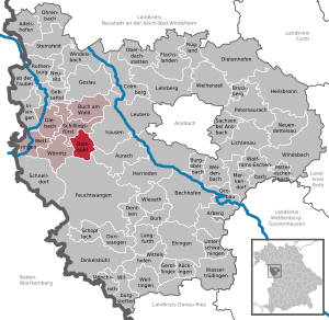
| Location of the Dombühl market in the Ansbach district | ||
  |
||

Dombühl is a market in the Central Franconian district of Ansbach and a member of the Schillingsfürst administrative community .
geography
Geographical location
The municipality is located in the Frankenhöhe Nature Park , in the federal state of Bavaria, Central Franconia district, in the western district of Ansbach. Dombühl is a train station on the Heilbronn - Nuremberg route, between the Crailsheim and Ansbach junction stations.
Neighboring communities
The neighboring municipalities are (starting in the north in a clockwise direction):
Community structure
The municipality has eight officially named municipality parts (the type of settlement is indicated in brackets ):
|
|
There are also the Auhof and Ziegelhütte residential areas , neither of which are officially designated parts of the community.
history

Until the church is planted
The place is first mentioned in a document in 1238 as "Tanpuel". The place name is derived from a field name of the same name, the basic word of which is "bühel" ( mhd .: Hill) and the defining word "tan" (mhd .: fir forest ), meaning a hilly area covered with fir trees.
Dombühl was in the Fraisch district of the Ansbach Oberamt Feuchtwangen . In 1732 there were 50 properties with 51 teams. The village and community rulership was held by the Eichstättische Oberamt Wahrberg-Herrieden . The landlords were the monastery administration office Sulz (2 estates) and the Oberamt Wahrberg-Herrieden (33 properties, 2 properties with forge, 9 properties with baking rights, 3 properties with business, 1 property with bathroom). There was also 1 church (Protestant) with a cemetery, 1 schoolhouse, 1 town hall, 1 shepherd's house. Nothing in these conditions changed until the end of the Old Kingdom .
From 1797 to 1808 the place was subordinate to the Justice and Chamber Office Feuchtwangen . In 1803 the Eichstatt subjects came to the now Prussian administrative area of Ansbach-Bayreuth in the course of secularization , which in turn was incorporated into the newly founded Kingdom of Bavaria in 1806.
With the community edict (early 19th century) the tax district Dombühl was formed, to which the places Baimhofen , Binsenweiler , Bortenberg , Bühl , Höfen , Höfstettermühle , Kloster Sulz , Vehlberg and Ziegelhaus belonged. A little later, the rural community of Dombühl was formed, to which the villages of Höfen and Höfstettermühle belonged. It was subject to the Feuchtwangen Regional Court in terms of administration and jurisdiction . The community originally had an area of 9.772 km².
Incorporation
On April 1, 1971, the previously independent community of Kloster Sulz, which was called Sulz until 1952, was incorporated.
Population development
In the period from 1988 to 2018, the population rose from 1126 to 1758 by 632 inhabitants or by 56.1% - the second highest percentage increase in the period mentioned in the Ansbach district after Wörnitz .
Dombühl municipality
| year | 1818 | 1840 | 1852 | 1861 | 1867 | 1871 | 1875 | 1880 | 1885 | 1890 | 1895 | 1900 | 1905 | 1910 | 1919 | 1925 | 1933 | 1939 | 1946 | 1950 | 1961 | 1970 | 1987 | 2005 | 2011 | 2015 |
|---|---|---|---|---|---|---|---|---|---|---|---|---|---|---|---|---|---|---|---|---|---|---|---|---|---|---|
| Residents | 355 | 433 | 418 | 411 | 439 | 443 | 581 | 520 | 522 | 503 | 491 | 515 | 538 | 584 | 596 | 578 | 601 | 589 | 942 | 902 | 776 | 792 | 1119 | 1670 | 1635 | 1739 |
| Houses | 67 | 71 | 85 | 83 | 104 | 107 | 119 | 150 | 332 | 451 | 458 | |||||||||||||||
| source |
Part of the municipality Dombühl
| year | 1818 | 1840 | 1861 | 1871 | 1885 | 1900 | 1925 | 1950 | 1961 | 1970 | 1987 |
|---|---|---|---|---|---|---|---|---|---|---|---|
| Residents | 337 | 406 | 390 | 405 | 481 | 481 | 541 | 873 | 746 | 772 | 775 |
| Houses | 62 | 766 | 78 | 102 | 115 | 146 | 123 | 226 | |||
| source |
religion
Evangelical Lutheran
The Lutheran rectory in Dombühl with the Church of St. Veit in Dombühl and the Church of St. Mary in Sulz Monastery belong to the Feuchtwangen deanery of the Ansbach-Würzburg parish of the Evangelical Lutheran Church in Bavaria .
Pastor Klaus Lindner, who also works as a cabaret artist in the Franconian Church Cabaret ("FKK" for short), and with his band Highway to Heal , which was founded in Dombühl in 2012, is currently responsible for various church services in the surrounding parishes and parishes, is currently responsible for the leadership of the parish of Dombühl and Sulz Monastery Deaneries designed musically to make church visits more attractive for all age groups.
Catholic
A Catholic branch church is looked after by the Schillingsfürst parish office (Deanery Ansbach, Archdiocese of Bamberg ). The Sunday service (evening mass) only takes place every two weeks.
politics
Municipal council
After the last local election on March 16, 2014 , the local council has twelve members. The turnout was 61.95%. The choice brought the following result:
| Free electoral association | 6 seats | (53.13%) |
| Free community of voters | 6 seats | (46.87%) |
mayor
Jürgen Geier (FWVD) is the first mayor of the Dombühl market. Other functions: Deputy Chairman of the VG Schillingsfürst, member of the management of the Hesselberg region, member of the association in the InterFranken association. Jürgen Geier was elected to succeed Helmut Auer in March 2014 with 57.31 percent of the vote.
badges and flags
The municipality of Dombühl has had a coat of arms since 1986.
|
|
Blazon : "In red on a green mountain, the silver fortified church of Dombühl with black roofs, on the right above the nave, a shield made of silver and black crossed ."
Green-white-green municipality flag |
| Justification for the coat of arms: The church on the hill stands for the no longer understood place name, which means "hill with trees", and the local church of St. Vitus. The shield with the tariff in silver and black reminds of the territorial sovereignty of the margraves. |
Architectural monuments
Soil monuments
Economy and Infrastructure
tourism
Dombühl is a member of the tourism associations frankenTourismus, Romantisches Franken and the tourist association Frankenhöhe.
InterFranken business park
Dombühl is a member of the InterFranken industrial and commercial park association.
traffic
Public transport
Dombühl is on the Nuremberg – Crailsheim railway line . Regional Express trains to Nuremberg and Stuttgart run every two hours . In December 2017, Dombühl was integrated into the network of the Nuremberg S-Bahn . Since then, the S4 line has provided an additional two-hour connection via Ansbach to Nuremberg as well as better connections to the buses. In addition, the municipality is redesigning the station area and renovating the reception building.
The Nördlingen – Dombühl railway was used for freight traffic to Feuchtwangen until December 31, 2018. There are plans to reactivate passenger transport to Dinkelsbühl or Wilburgstetten .
Until 1971, the Steinach near Rothenburg – Dombühl railway branched off in Dombühl . This has been closed between Dombühl and Rothenburg ob der Tauber, the tracks have been dismantled. The route is partly used for a bike path.
Private transport
The district road AN 4 crosses the state road 2419 to Ulrichshausen or to Sulz monastery . The district road AN 35 crosses the state road 2246 to Schillingsfürst . Communal roads lead to Bortenberg , Archshofen and Ziegelhaus . Via the state road 2419 you can get to junction 49 of federal highway 6 or junction 109 of federal highway 7 .
Sons and daughters of the church
- Theodor Enslin , bookseller, bibliographer, publisher and honorary citizen of the city of Leipzig , was born on November 18, 1787 in Kloster Sulz; † May 22, 1851 in Berlin
literature
- Johann Kaspar Bundschuh : Donbühl . In: Geographical Statistical-Topographical Lexicon of Franconia . tape 1 : A-egg . Verlag der Stettinische Buchhandlung, Ulm 1799, DNB 790364298 , OCLC 833753073 , Sp. 631-632 ( digitized version ).
- Hans Karlmann Ramisch: District of Rothenburg ob der Tauber (= Bavarian art monuments . Volume 25 ). Deutscher Kunstverlag, Munich 1967, DNB 457879254 , p. 25-27 .
- Wolf-Armin von Reitzenstein : Lexicon of Franconian place names. Origin and meaning . Upper Franconia, Middle Franconia, Lower Franconia. CH Beck, Munich 2009, ISBN 978-3-406-59131-0 , p. 56 .
- Pleikard Joseph Stumpf : Dombühl . In: Bavaria: a geographical-statistical-historical handbook of the kingdom; for the Bavarian people . Second part. Munich 1853, p. 717 ( digitized version ).
Web links
- Local government
- Dombühl in the Topographia Franconiae of the University of Würzburg , accessed on September 19, 2019.
- Dombühl: Official statistics of the LfStat
Individual evidence
- ↑ "Data 2" sheet, Statistical Report A1200C 202041 Population of the municipalities, districts and administrative districts 1st quarter 2020 (population based on the 2011 census) ( help ).
- ↑ Legislative period from May 1st, 2020 to April 30th, 2026. Municipality of Dombühl, accessed on June 9, 2020 .
- ^ Community Dombühl in the local database of the Bavarian State Library Online . Bayerische Staatsbibliothek, accessed on September 19, 2019.
- ↑ W.-A. v. Reitzenstein, p. 56.
- ↑ According to the Vetterische description of the Oberamt Feuchtwangen from 1732 ( see also Dombühl ( manorial rule) on the website geschichte-feuchtwangen.de).
- ↑ Johann Bernhard Fischer : Donbühl . In: Statistical and topographical description of the Burggraftum Nürnberg, below the mountain, or the Principality of Brandenburg-Anspach. Second part. Containing the economic, statistical and moral condition of these countries according to the fifteen upper offices . Benedict Friedrich Haueisen, Ansbach 1790, p. 184 ( digitized version ).
- ↑ JK Bundschuh, Vol. 1, Col. 631.
- ^ Address and statistical manual for the Rezatkreis in the Kingdom of Baiern . Buchdruckerei Chancellery, Ansbach 1820, p. 35 ( digitized version ).
- ↑ a b c Bavarian State Statistical Office (ed.): Official city directory for Bavaria, territorial status on October 1, 1964 with statistical information from the 1961 census . Issue 260 of the articles on Bavaria's statistics. Munich 1964, DNB 453660959 , Section II, Sp. 813 ( digitized version ).
- ^ Wilhelm Volkert (ed.): Handbook of Bavarian offices, communities and courts 1799–1980 . CH Beck, Munich 1983, ISBN 3-406-09669-7 , p. 562 .
- ↑ a b Only inhabited houses are given. In 1818 these were designated as fireplaces , in 1840 as houses , and from 1871 to 2015 as residential buildings.
- ↑ a b Alphabetical index of all the localities contained in the Rezatkreise according to its constitution by the newest organization: with indication of a. the tax districts, b. Judicial Districts, c. Rent offices in which they are located, then several other statistical notes . Ansbach 1818, p. 19 ( digitized version ). For the municipality of Dombühl plus the residents and buildings of Höfen (p. 41) and Höfstettermühle (p. 42).
- ^ A b Eduard Vetter (Ed.): Statistical handbook and address book of Middle Franconia in the Kingdom of Bavaria . Self-published, Ansbach 1846, p. 108 ( digitized version ).
- ^ A b c d e f g h i Bavarian State Statistical Office (Hrsg.): Historical municipality directory: The population of the municipalities of Bavaria from 1840 to 1952 (= contributions to Statistics Bavaria . Issue 192). Munich 1954, DNB 451478568 , p. 182 , urn : nbn: de: bvb: 12-bsb00066439-3 ( digitized version ).
- ↑ a b Joseph Heyberger, Chr. Schmitt, v. Wachter: Topographical-statistical manual of the Kingdom of Bavaria with an alphabetical local dictionary . In: K. Bayer. Statistical Bureau (Ed.): Bavaria. Regional and folklore of the Kingdom of Bavaria . tape 5 . Literary and artistic establishment of the JG Cotta'schen Buchhandlung, Munich 1867, Sp. 1074 , urn : nbn: de: bvb: 12-bsb10374496-4 ( digital copy ).
- ↑ Kgl. Statistisches Bureau (Ed.): Directory of the municipalities of the Kingdom of Bavaria according to the status of the population in December 1867 . XXI. Issue of the contributions to the statistics of the Kingdom of Bavaria. Ackermann, Munich 1869, p. 172 ( digitized version ).
- ↑ a b Kgl. Statistical Bureau (ed.): Complete list of localities of the Kingdom of Bavaria. According to districts, administrative districts, court districts and municipalities, including parish, school and post office affiliation ... with an alphabetical general register containing the population according to the results of the census of December 1, 1875 . Adolf Ackermann, Munich 1877, 2nd section (population figures from 1871, cattle figures from 1873), Sp. 1241 , urn : nbn: de: bvb: 12-bsb00052489-4 ( digitized version ).
- ↑ K. Bayer. Statistical Bureau (ed.): Community directory for the Kingdom of Bavaria. Manufactured due to the new organization of government districts, district offices and judicial districts. Addendum to issue 36 of the articles on Bavaria's statistics. Munich 1879, p. 68 ( digitized version ).
- ↑ K. Bayer. Statistical Bureau (ed.): Community directory for the Kingdom of Bavaria. Results of the census of December 1, 1880. Issue 35 of the articles on Bavaria's statistics. Munich 1882, p. 195 ( digitized version ).
- ↑ a b K. Bayer. Statistical Bureau (Ed.): Localities directory of the Kingdom of Bavaria. According to government districts, administrative districts, ... then with an alphabetical register of locations, including the property and the responsible administrative district for each location. LIV. Issue of the contributions to the statistics of the Kingdom of Bavaria. Munich 1888, Section III, Sp. 1176-1177 ( digitized version ). Dombühl: 450 inhabitants, 72 residential buildings; Dombühl Bahnhof: 31 E., 6 Wgb.
- ↑ a b K. Bayer. Statistical Bureau (Ed.): Directory of localities of the Kingdom of Bavaria, with alphabetical register of places . LXV. Issue of the contributions to the statistics of the Kingdom of Bavaria. Munich 1904, Section II, Sp. 1247 ( digitized version ).
- ↑ a b Bavarian State Statistical Office (ed.): Localities directory for the Free State of Bavaria according to the census of June 16, 1925 and the territorial status of January 1, 1928 . Issue 109 of the articles on Bavaria's statistics. Munich 1928, Section II, Sp. 1282 ( digitized version ).
- ↑ a b Bavarian State Statistical Office (ed.): Official place directory for Bavaria - edited on the basis of the census of September 13, 1950 . Issue 169 of the articles on Bavaria's statistics. Munich 1952, DNB 453660975 , Section II, Sp. 1110 ( digitized version ).
- ↑ a b Bavarian State Statistical Office (Hrsg.): Official local directory for Bavaria . Issue 335 of the articles on Bavaria's statistics. Munich 1973, DNB 740801384 , p. 168 ( digitized version ).
- ↑ a b Bavarian State Office for Statistics and Data Processing (Ed.): Official local directory for Bavaria, territorial status: May 25, 1987 . Issue 450 of the articles on Bavaria's statistics. Munich November 1991, DNB 94240937X , p. 326 ( digitized version ).
- ↑ a b c Dombühl: Official statistics of the LfStat
- ↑ Preliminary results for the 2014 municipal council elections in Dombühl ( Memento of the original from July 14, 2014 in the Internet Archive ) Info: The archive link has been inserted automatically and has not yet been checked. Please check the original and archive link according to the instructions and then remove this notice.
- ^ Entry on the coat of arms of Dombühl in the database of the House of Bavarian History
- ↑ Dombühl. In: Kommunalflaggen.eu. Retrieved March 12, 2020 .
- ↑ Südwest Presse Online-Dienst GmbH: A plus point for rural areas . In: swp.de . ( swp.de [accessed on January 3, 2018]).

Adelshofen | Arberg | Aurach | Bechhofen | Bruckberg | Book at the forest | Burgoberbach | Burk | Colmberg | Dentlein am Forst | Diebach | Dietenhofen | Dinkelsbühl | Dombühl | Dürrwangen | Ehingen | Feuchtwangen | Flachslanden | Gebsattel | Gerolfingen | Geslau | Heilsbronn | Herrieden | Insingen | Langfurth | Lehrberg | Leutershausen | Lichtenau | Merkendorf | Mitteleschenbach | Mönchsroth | Neuendettelsau | Neusitz | Oberdachstetten | Ohrbach | Ornbau | Petersaurach | Röckingen | Rothenburg ob der Tauber | Rügland | Saxony near Ansbach | Schillingsfürst | Schnelldorf | Schopfloch | Steinsfeld | Unterschwaningen | Wassertrüdingen | Weidenbach | Weihenzell | Weiltingen | Wettringen | Wieseth | Wilburgstetten | Windelsbach | Windsbach | Wittelshofen | Wolframs-Eschenbach | Wörnitz
Unregulated areas:
Lower Forest