
Gebsattel
| coat of arms | Germany map | |
|---|---|---|

|
Coordinates: 49 ° 21 ' N , 10 ° 12' E |
|
| Basic data | ||
| State : | Bavaria | |
| Administrative region : | Middle Franconia | |
| County : | Ansbach | |
| Management Community : | Rothenburg ob der Tauber | |
| Height : | 373 m above sea level NHN | |
| Area : | 19.12 km 2 | |
| Residents: | 1719 (Dec. 31, 2019) | |
| Population density : | 90 inhabitants per km 2 | |
| Postal code : | 91607 | |
| Area code : | 09861 | |
| License plate : | AN , DKB, FEU, ROT | |
| Community key : | 09 5 71 152 | |
| LOCODE : | DE ZGL | |
| Community structure: | 9 parts of the community | |
| Address of the municipal administration: |
Schulstr. 10 91607 Gebsattel |
|
| Website : | ||
| Mayor : | Gerd Rößler ( SPD ) | |
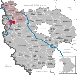
| Location of the municipality of Gebsattel in the district of Ansbach | ||
  |
||

Gebsattel is a municipality and a town in the Ansbach district in Middle Franconia .
geography
Geographical location
The community is located in the Frankenhöhe Nature Park , about three kilometers south of Rothenburg ob der Tauber , near the border with Baden-Württemberg .
Neighboring communities
- Rothenburg ob der Tauber
- Neusitz
- Geslau
- Windelsbach
- Book at the forest
- Schillingsfürst
- The stream
- Insingen
Community structure
There are nine officially named municipal parts (the type of settlement is given in brackets ):
|
|
history
Until the church is planted
Originally there were two places, the older church village on the left of the Tauber from the time of the Frankish conquest and the younger castle village on the right of the Tauber, which was owned by the Counts of Rothenburg-Komburg in the 11th century and named after the last owner from this house , the Countess Geba (Gebesedelen = seat of Geba) received. After 1400 about three quarters of the property belonged to the Benedictine monastery Komburg near Schwäbisch Hall, while a quarter of the residents were Rothenburg subjects. It was not until 1810 that Gebsattel came to the Kingdom of Bavaria .
With the community edict (early 19th century) the tax district Gebsattel was formed, to which the villages Dorfmühle, Eckartshof , Kirnberg , Leuzhof , Pleikartshof , Rödersdorf , Södelbronn , Wasenmühle and Wildenhof belonged. A little later, the rural community was formed with Dorfmühle, Eckartshof, Rödersdorf and Wasenmühle . It was subordinate to the regional court of Rothenburg in administration and jurisdiction .
In 1961 the municipality had an area of 10.162 km².
Incorporations
On January 1, 1972, the previously independent community of Kirnberg (with Pleikartshof, Speierhof, Wildenhof) was incorporated. Bockenfeld was added on May 1, 1978.
Population development
In the period from 1988 to 2018, the population increased from 1,428 to 1,730 by 302 inhabitants or 21.2%.
Gebsattel community
| year | 1818 | 1840 | 1852 | 1861 | 1867 | 1871 | 1875 | 1880 | 1885 | 1890 | 1895 | 1900 | 1905 | 1910 | 1919 | 1925 | 1933 | 1939 | 1946 | 1950 | 1961 | 1970 | 1987 | 1995 | 2005 | 2015 |
|---|---|---|---|---|---|---|---|---|---|---|---|---|---|---|---|---|---|---|---|---|---|---|---|---|---|---|
| Residents | 642 | 696 | 672 | 761 | 675 | 662 | 701 | 727 | 715 | 720 | 716 | 711 | 727 | 744 | 717 | 756 | 759 | 724 | 960 | 998 | 857 | 937 | 1425 | 1746 | 1830 | 1718 |
| Houses | 132 | 132 | 125 | 125 | 142 | 152 | 168 | 187 | 388 | 530 | ||||||||||||||||
| source |
Gebsattel municipality
| year | 1818 | 1840 | 1861 | 1871 | 1885 | 1900 | 1925 | 1950 | 1961 | 1970 | 1987 |
|---|---|---|---|---|---|---|---|---|---|---|---|
| Residents | 570 | 617 | 682 | 572 | 624 | 633 * | 672 * | 902 * | 790 * | 864 * | 959 * |
| Houses | 118 | 118 | 110 | 127 * | 137 * | 152 * | 171 * | 257 * | |||
| source |
politics
The community is a member of the Rothenburg ob der Tauber administrative community .
Municipal council
After the last local election on March 16, 2014 , the local council has twelve members, all of whom belong to the Common List group . The turnout was 57.8%. Another member and chairman of the municipal council is the mayor Gerd Rößler.
mayor
Gerd Rößler has been First Mayor since November 2010. His predecessor was Wilfried Schnaubelt. Rößler has been the full-time mayor since May 1, 2014.
badges and flags
Gebsattel has had a coat of arms since 1986.
|
|
Blazon : "By a silver wave pole split by blue and red, in front a golden, red-tongued lion head with a silver rafter in its mouth, in front a silver ibex trunk ."
Red-yellow-blue municipal flag. |
| Justification for the coat of arms: The silver wave pole stands for the Tauber , who flows through the municipality. The lion's head with rafters is taken from the coat of arms of the Counts of Rothenburg-Komburg. The head of the ibex is the coat of arms of the Barons von Gebsattel , who in the 19th century acquired property in Gebsattel that previously belonged to the Comburg monastery . |
Culture and sights
Attractions
- Maize labyrinth near Eckartshof
Music groups, orchestras, choirs and bands
- Musikverein Gebsattel (brass band)
- Gesangverein Frohsinn (choir)
- Lazy Bones (band)
- The Rudes (band)

Buildings
- Gebsattel Castle (privately owned, not open to the public)
- St. Laurentius Church with rectory
- Gasthaus zum Lamm
Economy and Infrastructure
The community is a member of the Romantic Franconian Tourist Association .
traffic
Gebsattel is close to the federal motorway 7 (junction 108 - Rothenburg ob der Tauber ). The national road 2249 goes according St. Leonhard or after Kirnberg . The district road AN 33 leads to Bockenfeld or Neusitz to the state road 2250 . Municipal roads lead to Eckartshof , crossing the St 2149 to Leuzhof , to the St 2149 at Sankt Leonhard and to Rödersdorf .
Established businesses
(Selection)
- Baß Antriebstechnik GmbH
- Metal construction wider
- Ostertag Schaltanlagen GmbH & Co KG
education
- Kindergarten St. Josef
- Primary school in Gebsattel-Insingen-Neusitz

societies
The Gebsattel music association was founded in June 1927 to provide musical accompaniment to church celebrations. Today the association is a brass band and has around 38 active members. In 2002/03 he built his own event hall with an attached rehearsal room.
The volunteer fire brigade consists of 34 fire service providers; Affiliated to this is the Rödersdorf fire fighting group with a further 12 fire fighters.
FV 68 Gebsattel was founded on May 18, 1968 and has around 400 members.
In April 2005 the evangelical rural youth Gebsattel was founded.
Other associations are the choral society Frohsinn, the motorcycle friends Kirnberg-Frankenhöhe as well as a beekeeping association, a horticultural association and a shooting association with around 120 members.
literature
- Johann Kaspar Bundschuh : Gebsattel . In: Geographical Statistical-Topographical Lexicon of Franconia . tape 2 : El-H . Verlag der Stettinische Buchhandlung, Ulm 1800, DNB 790364298 , OCLC 833753081 , Sp. 284-285 ( digitized version ).
- Hans Karlmann Ramisch: District of Rothenburg ob der Tauber (= Bavarian art monuments . Volume 25 ). Deutscher Kunstverlag, Munich 1967, DNB 457879254 , p. 38-43 .
- Wolf-Armin von Reitzenstein : Lexicon of Franconian place names. Origin and meaning . Upper Franconia, Middle Franconia, Lower Franconia. CH Beck, Munich 2009, ISBN 978-3-406-59131-0 , p. 79 .
- Pleikard Joseph Stumpf : Gebsattel . In: Bavaria: a geographical-statistical-historical handbook of the kingdom; for the Bavarian people . Second part. Munich 1853, p. 755 ( digitized version ).
Web links
- Local government
- Gebsattel in the Topographia Franconiae of the University of Würzburg , accessed on September 18, 2019.
- Gebsattel: Official statistics of the LfStat
Individual evidence
- ↑ "Data 2" sheet, Statistical Report A1200C 202041 Population of the municipalities, districts and administrative districts 1st quarter 2020 (population based on the 2011 census) ( help ).
- ^ Municipality of Gebsattel in the local database of the Bavarian State Library Online . Bayerische Staatsbibliothek, accessed on September 18, 2019.
- ↑ W.-A. v. Reitzenstein, p. 79.
- ^ Address and statistical manual for the Rezatkreis in the Kingdom of Baiern . Buchdruckerei Chancellery, Ansbach 1820, p. 66 ( digitized version ).
- ↑ a b c Eduard Vetter (Hrsg.): Statistical handbook and address book of Middle Franconia in the Kingdom of Bavaria . Self-published, Ansbach 1846, p. 223 ( digitized version ). According to the historical municipality register , the municipality had 688 inhabitants.
- ↑ a b c Bavarian State Statistical Office (ed.): Official city directory for Bavaria, territorial status on October 1, 1964 with statistical information from the 1961 census . Issue 260 of the articles on Bavaria's statistics. Munich 1964, DNB 453660959 , Section II, Sp. 814 ( digitized version ).
- ^ Wilhelm Volkert (ed.): Handbook of Bavarian offices, communities and courts 1799–1980 . CH Beck, Munich 1983, ISBN 3-406-09669-7 , p. 562 .
- ^ Federal Statistical Office (ed.): Historical municipality directory for the Federal Republic of Germany. Name, border and key number changes in municipalities, counties and administrative districts from May 27, 1970 to December 31, 1982 . W. Kohlhammer, Stuttgart / Mainz 1983, ISBN 3-17-003263-1 , p. 706, 724 .
- ↑ a b Only inhabited houses are given. In 1818 these were designated as fireplaces , in 1840 as houses , and from 1871 to 1987 as residential buildings.
- ↑ a b Alphabetical index of all the localities contained in the Rezatkreise according to its constitution by the newest organization: with indication of a. the tax districts, b. Judicial Districts, c. Rent offices in which they are located, then several other statistical notes . Ansbach 1818, p. 29 ( digitized version ). For the municipality of Gebsattel plus the residents and buildings of Eckartshof (p. 20), Rödersdorf (p. 76) and Wasenmühle (p. 98).
- ^ A b c d e f g h i Bavarian State Statistical Office (Hrsg.): Historical municipality directory: The population of the municipalities of Bavaria from 1840 to 1952 (= contributions to Statistics Bavaria . Issue 192). Munich 1954, DNB 451478568 , p. 182 , urn : nbn: de: bvb: 12-bsb00066439-3 ( digitized version ).
- ↑ a b Joseph Heyberger, Chr. Schmitt, v. Wachter: Topographical-statistical manual of the Kingdom of Bavaria with an alphabetical local dictionary . In: K. Bayer. Statistical Bureau (Ed.): Bavaria. Regional and folklore of the Kingdom of Bavaria . tape 5 . Literary and artistic establishment of the JG Cotta'schen Buchhandlung, Munich 1867, Sp. 1072 , urn : nbn: de: bvb: 12-bsb10374496-4 ( digitized version ).
- ↑ Kgl. Statistisches Bureau (Ed.): Directory of the municipalities of the Kingdom of Bavaria according to the status of the population in December 1867 . XXI. Issue of the contributions to the statistics of the Kingdom of Bavaria. Ackermann, Munich 1869, p. 171 ( digitized version ).
- ↑ a b Kgl. Statistical Bureau (ed.): Complete list of localities of the Kingdom of Bavaria. According to districts, administrative districts, court districts and municipalities, including parish, school and post office affiliation ... with an alphabetical general register containing the population according to the results of the census of December 1, 1875 . Adolf Ackermann, Munich 1877, 2nd section (population figures from 1871, cattle figures from 1873), Sp. 1237–1238 , urn : nbn: de: bvb: 12-bsb00052489-4 ( digitized version ).
- ↑ K. Bayer. Statistical Bureau (ed.): Community directory for the Kingdom of Bavaria. Manufactured due to the new organization of government districts, district offices and judicial districts. Addendum to issue 36 of the articles on Bavaria's statistics. Munich 1879, p. 68 ( digitized version ).
- ↑ K. Bayer. Statistical Bureau (ed.): Community directory for the Kingdom of Bavaria. Results of the census of December 1, 1880. Issue 35 of the articles on Bavaria's statistics. Munich 1882, p. 194 ( digitized version ).
- ↑ a b K. Bayer. Statistical Bureau (Ed.): Localities directory of the Kingdom of Bavaria. According to government districts, administrative districts, ... then with an alphabetical register of locations, including the property and the responsible administrative district for each location. LIV. Issue of the contributions to the statistics of the Kingdom of Bavaria. Munich 1888, Section III, Sp. 1173 ( digitized version ).
- ↑ a b K. Bayer. Statistical Bureau (Ed.): Directory of localities of the Kingdom of Bavaria, with alphabetical register of places . LXV. Issue of the contributions to the statistics of the Kingdom of Bavaria. Munich 1904, Section II, Sp. 1244 ( digitized version ).
- ↑ a b Bavarian State Statistical Office (ed.): Localities directory for the Free State of Bavaria according to the census of June 16, 1925 and the territorial status of January 1, 1928 . Issue 109 of the articles on Bavaria's statistics. Munich 1928, Section II, Sp. 1284 ( digitized version ).
- ↑ a b Bavarian State Statistical Office (ed.): Official place directory for Bavaria - edited on the basis of the census of September 13, 1950 . Issue 169 of the articles on Bavaria's statistics. Munich 1952, DNB 453660975 , Section II, Sp. 1111 ( digitized version ).
- ↑ a b Bavarian State Statistical Office (Hrsg.): Official local directory for Bavaria . Issue 335 of the articles on Bavaria's statistics. Munich 1973, DNB 740801384 , p. 169 ( digitized version ).
- ↑ a b Bavarian State Office for Statistics and Data Processing (Ed.): Official local directory for Bavaria, territorial status: May 25, 1987 . Issue 450 of the articles on Bavaria's statistics. Munich November 1991, DNB 94240937X , p. 327 ( digitized version ).
- ↑ Gebsattel: Official statistics of the LfStat
- ^ Gebsattel municipality. Ansbach District Office, accessed on July 18, 2020 .
- ↑ Gebsattel with unchanged peak , nordbayern.de, May 7, 2014, accessed October 25, 2018
- ↑ Entry on Gebsattel's coat of arms in the database of the House of Bavarian History
- ↑ Gebsattel. In: Kommunalflaggen.eu. Retrieved February 27, 2020 .

Adelshofen | Arberg | Aurach | Bechhofen | Bruckberg | Book at the forest | Burgoberbach | Burk | Colmberg | Dentlein am Forst | Diebach | Dietenhofen | Dinkelsbühl | Dombühl | Dürrwangen | Ehingen | Feuchtwangen | Flachslanden | Gebsattel | Gerolfingen | Geslau | Heilsbronn | Herrieden | Insingen | Langfurth | Lehrberg | Leutershausen | Lichtenau | Merkendorf | Mitteleschenbach | Mönchsroth | Neuendettelsau | Neusitz | Oberdachstetten | Ohrbach | Ornbau | Petersaurach | Röckingen | Rothenburg ob der Tauber | Rügland | Saxony near Ansbach | Schillingsfürst | Schnelldorf | Schopfloch | Steinsfeld | Unterschwaningen | Wassertrüdingen | Weidenbach | Weihenzell | Weiltingen | Wettringen | Wieseth | Wilburgstetten | Windelsbach | Windsbach | Wittelshofen | Wolframs-Eschenbach | Wörnitz
Unregulated areas:
Lower Forest