
Wörnitz (municipality)
| coat of arms | Germany map | |
|---|---|---|

|
Coordinates: 49 ° 15 ' N , 10 ° 15' E |
|
| Basic data | ||
| State : | Bavaria | |
| Administrative region : | Middle Franconia | |
| County : | Ansbach | |
| Management Community : | Schillingsfürst | |
| Height : | 466 m above sea level NHN | |
| Area : | 24.46 km 2 | |
| Residents: | 1834 (Dec. 31, 2019) | |
| Population density : | 75 inhabitants per km 2 | |
| Postal code : | 91637 | |
| Primaries : | 09868, 07950 , 09869 | |
| License plate : | AN , DKB, FEU, ROT | |
| Community key : | 09 5 71 228 | |
| LOCODE : | DE WOZ | |
| Community structure: | 17 parts of the community | |
| Address of the municipal administration: |
Rothenburger Str. 10 91637 Wörnitz |
|
| Website : | ||
| Mayor : | Karl Beck ( General Independent Citizens ) | |
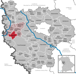
| Location of the municipality of Wörnitz in the district of Ansbach | ||
  |
||

Wörnitz is a municipality in the district of Ansbach in Middle Franconia . The community is a member of the Schillingsfürst administrative community .
geography
Geographical location
Wörnitz is located in the Frankenhöhe Nature Park ; The Wörnitz flows through the municipality .
Neighboring communities
The neighboring municipalities are (starting in the north in a clockwise direction):
Community structure
The municipality has 17 officially named municipal parts (the type of settlement is given in brackets ):
|
|
|
Felsenkeller , Morrieden and Sandmühle are not officially named parts of the municipality.
climate

Diagram of mean precipitation values in Wörnitz for the period from 1961 to 1990


In Wörnitz, the average annual rainfall is 800 mm.
Place name
The place is first mentioned in a document in 1357 as "Nydern Werntzze". The place name is derived from the Wörnitz river of the same name, which flows through the municipality .
history
Until the church is planted
The main town of Wörnitz is located at the crossroads of formerly important military roads and was destroyed several times in the Middle Ages and early modern times. An old settlement on today's Brambach corridor is said to have been completely burned down in 1388. In 1449 parts of the Wörnitz district were again devastated. In the Thirty Years War , the place was destroyed several times from 1632. Dense fog, which made the village invisible to the imperial and Croatian troops ( called Turks because of their colorful uniforms ), has spared the place from further destruction. Since then, the so-called Turks' bell has been taking place in Wörnitz at eight o'clock in the morning .
With the community edict (early 19th century) the tax district Wettringen was formed, to which the places Bastenau , Bösennördlingen , Ebertsmühle , Groß- and Kleinulrichshausen , Mittelstetten , Morrieden , Oberwörnitz , Riedenberg , Rosenhof , Sandmühle and Unterwörnitz belonged. A little later the rural community Wettringen was formed, to which all places of the tax district plus Walkersdorf were assigned . It was subordinate to the regional court of Rothenburg in administration and jurisdiction . In 1961 the municipality had an area of 11.506 km².
20th century
The town center was extensively renovated in 1990. A large sculpture was placed on the village square in front of the village church of St. Martin, reminding of the repeated destruction of the place and the sparing of the "Turks".
Incorporations
On November 1, 1971, the independent communities of Bottenweiler and Erzberg were merged with Wörnitz.
Population development
In the period from 1988 to 2018, the population increased from 1149 to 1806 by 657 inhabitants or 57.2% - the highest percentage increase in the Ansbach district in the period mentioned.
Wörnitz municipality
| year | 1818 | 1840 | 1852 | 1861 | 1867 | 1871 | 1875 | 1880 | 1885 | 1890 | 1895 | 1900 | 1905 | 1910 | 1919 | 1925 | 1933 | 1939 | 1946 | 1950 | 1961 | 1970 | 1987 | 1995 | 2005 | 2015 |
|---|---|---|---|---|---|---|---|---|---|---|---|---|---|---|---|---|---|---|---|---|---|---|---|---|---|---|
| Residents | 484 | 574 | 568 | 569 | 528 | 522 | 529 | 551 | 541 | 544 | 544 | 515 | 540 | 538 | 531 | 522 | 500 | 480 | 637 | 655 | 531 | 585 | 1138 | 1528 | 1640 | 1772 |
| Houses | 92 | 105 | 106 | 112 | 115 | 115 | 109 | 120 | 309 | 466 | ||||||||||||||||
| source |
Part of the municipality (Lower) Wörnitz
| year | 1818 | 1840 | 1861 | 1871 | 1885 | 1900 | 1925 | 1950 | 1961 | 1970 | 1987 |
|---|---|---|---|---|---|---|---|---|---|---|---|
| Residents | 137 | 159 | 153 | 133 | 165 | 147 * | 173 * | 255 * | 178 | 215 | 456 |
| Houses | 27 | 34 | 35 | 38 * | 42 * | 41 * | 44 | 128 | |||
| source |
politics
Municipal council
After the last local election on March 16, 2014 , the local council has twelve members, all of whom belong to the Free Voting Group . The turnout was 52.44%. Another member and chairman of the municipal council is the mayor.
mayor
Karl Beck has been the mayor since May 2002.
badges and flags
The municipality of Wörnitz has had its own coat of arms since 1984.
|
|
Blazon : "In silver, a green linden tree growing out of a green three-mountain, which is covered with a silver wave bar, flanked by two red tin towers, which are connected by a red wall."
Red-white-green municipal flag |
| Justification of the coat of arms: The two red towers come from the coat of arms of the imperial city of Rothenburg , which Wörnitz was in possession of from 1406 to 1803. The green linden tree represents the old judicial linden tree of Wörnitz. The green three mountain with the wavy bar symbolizes the agricultural structure and the geographic location of the municipality in the valley of the Wörnitz . |
Culture and sights

Buildings
The village church of St. Martin is located in the center of Wörnitz . In the village square in front of it there is an old linden tree . A sculpture reminds of the sparing of the place in the Thirty Years War, the land consolidation in 1977 and the village renewal in 1990.
Architectural monuments
Regular events
Every two years in September in southern Germany's largest commercial vehicle - classic car meeting held in Wörnitz. At the 11th meeting in 2009, around 300 vehicles from all over Germany and other European countries were represented.
The consecration of the St. Martin Church in Wörnitz, including the festivities, consisting of a festive church service, entertainment program, and several cultural and culinary offers from the local associations, takes place annually on a weekend in October (usually between October 21 and October 24) in the center of the village Georg-Ehnes-Platz.
Economy and Infrastructure
Wörnitz is a member of the Romantic Franconian Tourist Association.
traffic
The national road 2419 , the part of the romantic road is leading to the junction 109 of the Bundesautobahn 7 or on Mittelstetten past the junction 49 of the Bundesautobahn 6 . The district road AN 5 leads to Bösennördlingen or via Oberwörnitz to St 2246 . The district road AN 16 leads to Bastenau . Communal roads lead to Bersbronn , Ulrichshausen and past the sand mill to Mittelstetten .
The place had a stop on the Steinach near Rothenburg – Dombühl railway line, which was closed in 1971 .
Personalities
- Georg Ehnes (1920–1991), a former member of the CSU state parliament and Bundestag, comes from Mittelstetten.
literature
- Johann Kaspar Bundschuh : Wörnitz . In: Geographical Statistical-Topographical Lexicon of Franconia . tape 6 : V-Z . Verlag der Stettinische Buchhandlung, Ulm 1804, DNB 790364328 , OCLC 833753116 , Sp. 279-280 ( digitized version ).
- Hans Karlmann Ramisch: District of Rothenburg ob der Tauber (= Bavarian art monuments . Volume 25 ). Deutscher Kunstverlag, Munich 1967, DNB 457879254 , p. 118-119 .
- Wolf-Armin von Reitzenstein : Lexicon of Franconian place names. Origin and meaning . Upper Franconia, Middle Franconia, Lower Franconia. CH Beck, Munich 2009, ISBN 978-3-406-59131-0 , p. 247 .
- Pleikard Joseph Stumpf : Wörnitz . In: Bavaria: a geographical-statistical-historical handbook of the kingdom; for the Bavarian people . Second part. Munich 1853, p. 754 ( digitized version ).
Web links
- Map of the municipality of Wörnitz on the BayernAtlas
- Wörnitz in the Topographia Franconiae of the University of Würzburg , accessed on September 19, 2019.
- Wörnitz (municipality): Official statistics of the LfStat
Individual evidence
- ↑ "Data 2" sheet, Statistical Report A1200C 202041 Population of the municipalities, districts and administrative districts 1st quarter 2020 (population based on the 2011 census) ( help ).
- ^ Community Wörnitz in the local database of the Bavarian State Library Online . Bayerische Staatsbibliothek, accessed on September 19, 2019.
- ↑ W.-A. v. Reitzenstein, p. 247.
- ^ Address and statistical manual for the Rezatkreis in the Kingdom of Baiern . Buchdruckerei Chancellery, Ansbach 1820, p. 67 ( digitized version ).
- ↑ a b c Eduard Vetter (Hrsg.): Statistical handbook and address book of Middle Franconia in the Kingdom of Bavaria . Self-published, Ansbach 1846, p. 227-228 ( digitized version ). According to the historical municipality register , the municipality had 572 inhabitants.
- ↑ a b c Bavarian State Statistical Office (ed.): Official city directory for Bavaria, territorial status on October 1, 1964 with statistical information from the 1961 census . Issue 260 of the articles on Bavaria's statistics. Munich 1964, DNB 453660959 , Section II, Sp. 818 ( digitized version ).
- ^ Friedrich Ringler (President of the Land Consolidation Directorate Ansbach): A sign of rural reorganization through land consolidation and village renewal in Wörnitz
- ^ Wilhelm Volkert (ed.): Handbook of Bavarian offices, communities and courts 1799–1980 . CH Beck, Munich 1983, ISBN 3-406-09669-7 , p. 562 .
- ↑ a b Only inhabited houses are given. In 1818 these were designated as fireplaces , in 1840 as houses , and from 1871 to 2015 as residential buildings.
- ↑ a b Alphabetical index of all the localities contained in the Rezatkreise according to its constitution by the newest organization: with indication of a. the tax districts, b. Judicial Districts, c. Rent offices in which they are located, then several other statistical notes . Ansbach 1818, p. 96 ( digitized version ). For the community of (Unter-) Wörnitz plus the residents and buildings of Bösennördlingen (p. 11), Ebertsmühle (p. 20), Großulrichshausen (p. 33), Kleinulrichshausen (p. 49), Mittelstetten (p. 60), Mörrieden (P. 60), Oberwörnitz (p. 69), Riedenberg (p. 76), Rosenhof (p. 77), Sandmühle (p. 80) and Walkersdorf (p. 99).
- ^ A b c d e f g h i Bavarian State Statistical Office (Hrsg.): Historical municipality directory: The population of the municipalities of Bavaria from 1840 to 1952 (= contributions to Statistics Bavaria . Issue 192). Munich 1954, DNB 451478568 , p. 182 , urn : nbn: de: bvb: 12-bsb00066439-3 ( digitized version ).
- ↑ a b Joseph Heyberger, Chr. Schmitt, v. Wachter: Topographical-statistical manual of the Kingdom of Bavaria with an alphabetical local dictionary . In: K. Bayer. Statistical Bureau (Ed.): Bavaria. Regional and folklore of the Kingdom of Bavaria . tape 5 . Literary and artistic establishment of the JG Cotta'schen Buchhandlung, Munich 1867, Sp. 1076 , urn : nbn: de: bvb: 12-bsb10374496-4 ( digitized version ).
- ↑ Kgl. Statistisches Bureau (Ed.): Directory of the municipalities of the Kingdom of Bavaria according to the status of the population in December 1867 . XXI. Issue of the contributions to the statistics of the Kingdom of Bavaria. Ackermann, Munich 1869, p. 172 ( digitized version ).
- ↑ a b Kgl. Statistical Bureau (ed.): Complete list of localities of the Kingdom of Bavaria. According to districts, administrative districts, court districts and municipalities, including parish, school and post office affiliation ... with an alphabetical general register containing the population according to the results of the census of December 1, 1875 . Adolf Ackermann, Munich 1877, 2nd section (population figures from 1871, cattle figures from 1873), Sp. 1244 , urn : nbn: de: bvb: 12-bsb00052489-4 ( digitized version ).
- ↑ K. Bayer. Statistical Bureau (ed.): Community directory for the Kingdom of Bavaria. Manufactured due to the new organization of government districts, district offices and judicial districts. Addendum to issue 36 of the articles on Bavaria's statistics. Munich 1879, p. 68 ( digitized version ).
- ↑ K. Bayer. Statistical Bureau (ed.): Community directory for the Kingdom of Bavaria. Results of the census of December 1, 1880. Issue 35 of the articles on Bavaria's statistics. Munich 1882, p. 195 ( digitized version ).
- ↑ a b K. Bayer. Statistical Bureau (Ed.): Localities directory of the Kingdom of Bavaria. According to government districts, administrative districts, ... then with an alphabetical register of locations, including the property and the responsible administrative district for each location. LIV. Issue of the contributions to the statistics of the Kingdom of Bavaria. Munich 1888, Section III, Sp. 1179–1180 ( digitized version ).
- ↑ a b K. Bayer. Statistical Bureau (Ed.): Directory of localities of the Kingdom of Bavaria, with alphabetical register of places . LXV. Issue of the contributions to the statistics of the Kingdom of Bavaria. Munich 1904, Section II, Sp. 1250 ( digitized version ).
- ↑ a b Bavarian State Statistical Office (ed.): Localities directory for the Free State of Bavaria according to the census of June 16, 1925 and the territorial status of January 1, 1928 . Issue 109 of the articles on Bavaria's statistics. Munich 1928, Section II, Sp. 1288 ( digitized version ).
- ↑ a b Bavarian State Statistical Office (ed.): Official place directory for Bavaria - edited on the basis of the census of September 13, 1950 . Issue 169 of the articles on Bavaria's statistics. Munich 1952, DNB 453660975 , Section II, Sp. 1115-1116 ( digitized version ).
- ↑ a b Bavarian State Statistical Office (Hrsg.): Official local directory for Bavaria . Issue 335 of the articles on Bavaria's statistics. Munich 1973, DNB 740801384 , p. 172 ( digitized version ).
- ↑ a b Bavarian State Office for Statistics and Data Processing (Ed.): Official local directory for Bavaria, territorial status: May 25, 1987 . Issue 450 of the articles on Bavaria's statistics. Munich November 1991, DNB 94240937X , p. 333 ( digitized version ).
- ^ Wörnitz (municipality): Official statistics of the LfStat
- ↑ http://www.wahlen.bayern.de/kommunalwahlen/
- ^ Entry on the coat of arms of Wörnitz (municipality) in the database of the House of Bavarian History
- ↑ Wörnitz. In: Kommunalflaggen.eu. Retrieved March 3, 2020 .

Adelshofen | Arberg | Aurach | Bechhofen | Bruckberg | Book at the forest | Burgoberbach | Burk | Colmberg | Dentlein am Forst | Diebach | Dietenhofen | Dinkelsbühl | Dombühl | Dürrwangen | Ehingen | Feuchtwangen | Flachslanden | Gebsattel | Gerolfingen | Geslau | Heilsbronn | Herrieden | Insingen | Langfurth | Lehrberg | Leutershausen | Lichtenau | Merkendorf | Mitteleschenbach | Mönchsroth | Neuendettelsau | Neusitz | Oberdachstetten | Ohrbach | Ornbau | Petersaurach | Röckingen | Rothenburg ob der Tauber | Rügland | Saxony near Ansbach | Schillingsfürst | Schnelldorf | Schopfloch | Steinsfeld | Unterschwaningen | Wassertrüdingen | Weidenbach | Weihenzell | Weiltingen | Wettringen | Wieseth | Wilburgstetten | Windelsbach | Windsbach | Wittelshofen | Wolframs-Eschenbach | Wörnitz
Unregulated areas:
Lower Forest