
Wolframs-Eschenbach
| coat of arms | Germany map | |
|---|---|---|

|
Coordinates: 49 ° 14 ' N , 10 ° 43' E |
|
| Basic data | ||
| State : | Bavaria | |
| Administrative region : | Middle Franconia | |
| County : | Ansbach | |
| Management Community : | Wolframs-Eschenbach | |
| Height : | 442 m above sea level NHN | |
| Area : | 25.47 km 2 | |
| Residents: | 3119 (Dec. 31, 2019) | |
| Population density : | 122 inhabitants per km 2 | |
| Postal code : | 91639 | |
| Area code : | 09875 | |
| License plate : | AN , DKB, FEU, ROT | |
| Community key : | 09 5 71 229 | |
| LOCODE : | DE WWV | |
| City structure: | 10 districts | |
City administration address : |
Wolfram-von-Eschenbach-Platz 1 91639 Wolframs-Eschenbach |
|
| Website : | ||
| First Mayor : | Michael Dörr ( CSU ) | |
| Location of the city of Wolframs-Eschenbach in the district of Ansbach | ||
  |
||


Wolframs-Eschenbach , until 1917 Obereschenbach , is a town in the Ansbach district in Middle Franconia . The place is the seat of the administrative community Wolframs-Eschenbach .
geography
Geographical location
The city is not far from the Franconian Lake District on the Castle Road .
Neighboring communities
| Lichtenau | ||
.svg)
|
Mitteleschenbach , Windsbach | |
| Merkendorf | Muhr am See , Haundorf |
Community structure
The municipality has 10 districts :
|
|
The Beierleinsmühle and Spiegelhof are not official districts.
history

Until the 19th century
The place was first mentioned in a document as "Eschelebach" in 1057/75. The place name is derived from the water body of the same name, the defining word of which is the ash . 1309 the form "Obern-Eschembach" is attested to distinguish it from nearby places of the same name ( Mitteleschenbach , Untereschenbach ).
In the 11th century Eschenbach belonged to the bishops of Eichstätt and towards the end of the 12th century various counts became the lords of Eschenbach and Obereschenbach. Around 1212/1220 Obereschenbach (since 1917 Wolframs-Eschenbach) was given as a gift to the Teutonic Order by the Counts of Wertheim . From this point on, the Teutonic Order played a significant role in the history of Eschenbach. He ruled the city for over 600 years. Eschenbach was on an important trade route and after some time became a regional trading center as well as a secular and spiritual center. On December 18, 1332, Emperor Ludwig the Bavarian granted the town town charter.
According to the Salbuch der Deutschordenskommende Nürnberg from 1343, the Eschenbach municipal bailiff owned 5 farms, 1 fiefdom, 1 estate, 73 farmsteads, 2 houses, the baths, 5 farmsteads, more than 66 acres of fields, meadows and gardens.
From 1500 to 1806 the city belonged to the Franconian Imperial Circle , because the Deutschordensballei Franken was incorporated into this Imperial Circle. Although the Teutonic Order was not abolished by a decree by Napoleon I until 1809, Bavaria had already enlisted the Kommende Ellingen with the office of (Wolframs-) Eschenbach in 1806 in the course of the abolition of knightly goods .
At the end of the 18th century there were 171 properties in Eschenbach. The high court , the village and community rulership and the lordship over all properties exercised the city bailiff office Eschenbach of the Teutonic order. There were also stately, communal and church buildings. From 1797 to 1808 the place was under the Justice and Chamber Office Windsbach . At that time there were 160 houses.
In 1806 Eschenbach came to the Kingdom of Bavaria . As part of the municipal edict, the Eschenbach tax district was formed in 1808 . The municipality of Eschenbach was founded in 1810 and was congruent with the tax district of Eschenbach. It was subject to the Heilsbronn Regional Court in administration and jurisdiction and the Windsbach Rent Office in the financial administration . From 1862 to 1879 Eschenbach was administered by the Heilsbronn district office, since 1880 by the Gunzenhausen district office ( renamed Gunzenhausen district in 1938 ) and the Gunzenhausen rent office ( renamed Gunzenhausen tax office in 1920 ). The jurisdiction remained with the district court Heilsbronn until 1879, since 1880 with the district court Gunzenhausen . The community originally had an area of 6.490 km².
20th century
On July 19, 1917, the city was at the instigation of Prelate Johann Baptist Kurz (May 18, 1881-18 February 1968) by a decree of King Ludwig III. Renamed by Bavaria von Obereschenbach in honor of Wolfram von Eschenbach from the family of the Lords of Eschenbach in Wolframs-Eschenbach .
Displaced persons from Silesia, Bohemia and Moravia moved to Wolframs-Eschenbach from 1945 and let the place grow.
Wolframs-Eschenbach has been a state-approved resort since 2007.
Incorporations
On January 1, 1972, the previously independent municipality of Reutern was incorporated. On July 1, 1972 Waizendorf came from the dissolved community Gerbersdorf . Biederbach and Selgenstadt followed on May 1, 1978.
Population development
In the period from 1988 to 2018, the population rose from 2,112 to 3,116, or by 47.5%.
Wolframs-Eschenbach community
| year | 1979 | 1987 | 1991 | 1995 | 2002 | 2005 | 2007 | 2008 | 2009 | 2010 | 2011 | 2012 | 2013 | 2014 | 2015 | 2016 |
|---|---|---|---|---|---|---|---|---|---|---|---|---|---|---|---|---|
| Residents | 2019 | 2086 | 2259 | 2671 | 2927 | 2881 | 2847 | 2870 | 2872 | 2872 | 2770 | 2817 | 2923 | 2934 | 3045 | 3060 |
| Houses | 545 | 836 | 843 | 847 | 861 | |||||||||||
| source |
Part of the municipality Wolframs-Eschenbach (= municipality Eschenbach until the regional reform)
| year | 1818 | 1840 | 1852 | 1855 | 1861 | 1867 | 1871 | 1875 | 1880 | 1885 | 1890 | 1895 | 1900 | 1905 | 1910 | 1919 | 1925 | 1933 | 1939 | 1946 | 1950 | 1952 | 1961 | 1970 | 1987 | 2014 |
|---|---|---|---|---|---|---|---|---|---|---|---|---|---|---|---|---|---|---|---|---|---|---|---|---|---|---|
| Residents | 803 | 1003 | 996 | 972 | 995 | 913 | 922 | 939 | 988 | 1005 | 953 | 941 | 953 | 940 | 966 | 987 | 1030 | 1039 | 980 | 1519 | 1514 | 1489 | 1520 | 1531 | 1640 | 2592 |
| Houses | 187 | 197 | 199 | 212 | 210 | 205 | 239 | 292 | 451 | |||||||||||||||||
| source |
Religions
The Catholic parish of Wolframs-Eschenbach is part of the Herrieden dean's office within the Eichstätt diocese . The current pastor is Jochen Scherzer.
In the city of Wolframs-Eschenbach there are 1786 Catholics with their main residence (as of December 1, 2010). The parish also includes 467 Catholic Christians in the neighboring town of Merkendorf. Monthly Sunday services are held for them in the local Protestant cemetery chapel St. Johannes.
The Wolframs-Eschenbacher Stadtpfarrkirche (also called Liebfrauenmünster ) is dedicated to the Assumption of Mary . There is also the St. Sebastian Church in the cemetery from the early 16th century (later redesigned in the Rococo style). In the district of Biederbach there is a branch church with the patronage of the Holy Family .
The approx. 500 Protestant Christians in Wolframs-Eschenbach belong to the Protestant parish in Merkendorf, three kilometers away. For church services in Wolframs-Eschenbach they are u. a. the Catholic cemetery church of St. Sebastian is available.
In Wolframs-Eschenbach there was a Jewish prayer room since 1802 , which was abandoned in 1933. Some Jews were brought to Hamburg via Erlangen and emigrated to the USA in 1933/1934 , some of them to the New England states, others to Texas and California .
The nearest Jewish institutions are now in Gunzenhausen, Ansbach and Weißenburg . The same is true for Muslim institutions.
politics
City council
After the local elections on March 15, 2020, the city council is composed as follows:
- Christian-Social Union in Bavaria / Independent citizens Wolframs-Eschenbach : 9 councilors (+1)
- Free voters Wolframs-Eschenbach : 7 city councilors (+1)
Total: 16 seats
badges and flags
Wolframs-Eschenbach has had its own coat of arms since the 14th century.
|
|
Blazon : "In green a slanting silver wave bar ."
Green and white municipal flag |
| Foundation of the coat of arms: A seal from 1368 is documented with the inscription CIVITAS OBERESCHENBACH. In the shield there is a sloping wave bar that speaks for the place name and is initially shown running on the right, later on the left. |
Town twinning
- Zöblitz in the Ore Mountains District , Free State of Saxony
- Schlettau in the Ore Mountains District, Free State of Saxony
- Donzenac in the Corrèze department in France
Culture and sights
Museums

- Wolfram von Eschenbach Museum
- The museum shows objects from the city's history such as fire equipment, guild chests and interest books.
Buildings
- The medieval city is surrounded by a completely preserved fortification (city wall) with two large gate towers as access to the city. There is also the Powder Tower and the Hunger Tower on the south side without gates.
- The Liebfrauenmünster, Catholic parish church and burial place of Wolfram von Eschenbach was built between 1220 and 1300 by the Teutonic Order as a hall church.
- Teutonic Order Castle
- Old Bailiwick
- Old Town Hall
- High house
- Beneficiary
- House Noah's Ark
- Lower city gate
- Upper city gate
- St. Sebastian
- At the exit of Wolframs-Eschenbach in Merkersdorfer Straße and the junction to Biedersbacher Straße you will find the stone cross group in Wolframs-Eschenbach .

Liebfrauenmünster and old town hall

Monument to Wolfram von Eschenbach
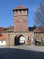
Lower gate
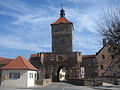
Upper gate

Statue of St. Walburga by Ernst Steinacker

Text board
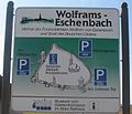
Rough map of Wolframs-Eschenbach

Shield of the Wolfram von Eschenbach Museum
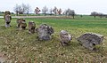
Eight stone crosses

.jpg)

.jpg)


Architectural monuments
→ List of architectural monuments in Wolframs-Eschenbach
Wolframs-Eschenbach as a film set
In 1974 Wolframs-Eschenbach served as the backdrop for the classic children's film The Robber Hotzenplotz with Gert Fröbe , Josef Meinrad , Rainer Basedow and Lina Carstens . In the end credits of the film, director Gustav Ehmck also explicitly named the local population as actors, and the name "Eschenbach" is also mentioned in the film.
Regular events
- Annually the award of the culture award of the district of Middle Franconia
- Parish fair on the third Sunday in August
- Old Town Festival (in July, every two years)
- Sternlesmarkt (in December)
- Robber Hotzenplotz Festival (on the first Sunday in August)
- Carnival parade (January / February)
- Since 2009, the open-air festival Echolot with electronic music has been taking place on the first Saturday in September on a nearby meadow .
- Oldie Town (every two years)
Gastronomy and accommodation
Several inns in Wolframs-Eschenbach offer typical Franconian cuisine. There are around 150 to 200 beds in hotels, guest houses, holiday homes and private individuals.
traffic
The national road 2220 extends over Gerbersdorf according Merkendorf or via Ismannsdorf to wind stream . The district road AN 12 leads to Biederbach or Wöltendorf , the AN 58 leads to Waizendorf . Communal roads lead to Reutern and Adelmannsdorf .
Personalities
Honorary citizen
- August Koch, general practitioner, worked in the city from 1938 to 1974
- Johann Baptist Kurz, collegiate dean and papal prelate, tungsten researcher
- Josef Maget (2002)
sons and daughters of the town
- Wolfram von Eschenbach (around 1170 – around 1220) is one of the most famous medieval poets and minstrels. His best known work is Parzival .
- Anton Weißmann (1871–1945), journalist and politician, member of the state parliament
- Franz Heidingsfelder (1882–1942), Professor of Church and Art History and Rector of the Philosophical-Theological University of Regensburg
- Georg Heidingsfelder (1887–1943), professor of philosophy and education at the Philosophical-Theological University of Eichstätt
- Friedrich Dörr (1908–1993), liturgical scientist a. a. at the University of Eichstätt , liturgist for the diocese of Eichstätt.
literature
- August Besner: Wolframs-Eschenbach (Schnell, art guide No. 1125). 3rd edition, Munich / Zurich 1987
- Johann Kaspar Bundschuh : Eschenbach . In: Geographical Statistical-Topographical Lexicon of Franconia . tape 2 : El-H . Verlag der Stettinische Buchhandlung, Ulm 1800, DNB 790364298 , OCLC 833753081 , Sp. 84 ( digitized version ).
- Friedrich Dumm: Brief history of the city of Eschenbach in Middle Franconia. Along with a treatise on the life and poetry of Wolfram von Eschenbach. Ansbach 1860 ( e-copy ).
- Oskar Geidner: Wolframs-Eschenbach. The citizens and their buildings. History of houses from 1423 to 1945. Nuremberg 2015 (sources and research on Franconian family history, 30). ISBN 978-3-929865-66-0
- Manfred Jehle: Ansbach: the margravial chief offices Ansbach, Colmberg-Leutershausen, Windsbach, the Nuremberg nursing office Lichtenau and the Deutschordensamt (Wolframs-) Eschenbach (= historical atlas of Bavaria, part Franconia . I, 35). Commission for Bavarian State History, Munich 2009, ISBN 978-3-7696-6856-8 .
- Hansgeorg Klauss et al. (Ed.): The district of Gunzenhausen . Verl. F. Authorities and Economy Hoeppner, Aßling-Pörsdorf / Obb. 1966, DNB 456843604 , p. 174-179 .
- Wolf-Armin von Reitzenstein : Lexicon of Franconian place names. Origin and meaning . Upper Franconia, Middle Franconia, Lower Franconia. CH Beck, Munich 2009, ISBN 978-3-406-59131-0 , p. 247 .
- Robert Schuh: Gunzenhausen (= historical book of place names of Bavaria, Middle Franconia . Volume 5 ). Michael Laßleben, Kallmünz 1979, ISBN 3-7696-9922-X , p. 83-86 .
- Erwin Seitz and Oskar Geidner: Wolframs-Eschenbach: the Teutonic Order is building a city . Wolframs-Eschenbach 1997
- Pleikard Joseph Stumpf : Eschenbach . In: Bavaria: a geographical-statistical-historical handbook of the kingdom; for the Bavarian people . Second part. Munich 1853, p. 729 ( digitized version ).
Web links
- Map of the city of Wolframs-Eschenbach on the BayernAtlas
- Wolframs-Eschenbach in the Topographia Franconiae of the University of Würzburg , accessed on September 16, 2019.
- Wolframs-Eschenbach: Official statistics of the LfStat
- Wolfram in Eschenbach
- Old bailiwick and Franconian crusaders
Individual evidence
- ↑ "Data 2" sheet, Statistical Report A1200C 202041 Population of the municipalities, districts and administrative districts 1st quarter 2020 (population based on the 2011 census) ( help ).
- ^ Community Wolframs-Eschenbach in the local database of the Bavarian State Library Online . Bavarian State Library, accessed on September 16, 2019.
- ↑ Is listed in the local registers from 1846 to 1885 as Stoll (a) mühle .
- ↑ Is listed in the local registers until 1831 as a district.
- ↑ W.-A. von Reitzenstein, p. 247
- ↑ Elfriede Würl: Kosmas and Damian. Your impact history in Franconia. In: Würzburg specialist prose studies. Contributions to medieval medicine, pharmacy and class history from the Würzburg Medical History Institute. Königshausen & Neumann, Würzburg 1995 (= Würzburg medical history research , 38), pp. 134–155; here: p. 154
- ^ State Archives Nuremberg , Reichsstadt Nürnberg, Salbuch 134 (= Gerhard Pfeifer (edit.): The oldest land records of the German Order Committees Nuremberg , Neustadt / Aisch 1981, pp. 55–78). Quoted from M. Jehle, Vol. 1, p. 531
- ↑ M. Jehle, Vol. 2, p. 932
- ^ Johann Bernhard Fischer : Eschenbach . In: Statistical and topographical description of the Burggraftum Nürnberg, below the mountain, or the Principality of Brandenburg-Anspach. Second part. Containing the economic, statistical and moral condition of these countries according to the fifteen upper offices . Benedict Friedrich Haueisen, Ansbach 1790, p. 405 ( digitized version ).
- ↑ JK Bundschuh, Vol. 2, Col. 84
- ^ State Archives Nuremberg , Government of Middle Franconia, Chamber of the Interior, Levy 1952, 3850: Formation of the municipal and rural communities in the Heilsbronn district court in 1810. Quoted from M. Jehle, vol. 2, p. 963
- ^ Address and statistical manual for the Rezatkreis in the Kingdom of Baiern . Buchdruckerei Chancellery, Ansbach 1820, p. 43 ( digitized version ).
- ↑ M. Jehle, Vol. 2, p. 1017
- ↑ a b Bavarian State Statistical Office (ed.): Official city directory for Bavaria, territorial status on October 1, 1964 with statistical information from the 1961 census . Issue 260 of the articles on Bavaria's statistics. Munich 1964, DNB 453660959 , Section II, Sp. 788 ( digitized version ).
- ↑ Honorary Citizen Dr. Dr. Johann Baptist Kurz on the city pages
- ^ Wilhelm Volkert (ed.): Handbook of Bavarian offices, communities and courts 1799–1980 . CH Beck, Munich 1983, ISBN 3-406-09669-7 , p. 477 .
- ^ Federal Statistical Office (ed.): Historical municipality directory for the Federal Republic of Germany. Name, border and key number changes in municipalities, counties and administrative districts from May 27, 1970 to December 31, 1982 . W. Kohlhammer, Stuttgart / Mainz 1983, ISBN 3-17-003263-1 , p. 707 .
- ↑ a b Only inhabited houses are given. In 1818 these were referred to as fireplaces , in 1840 as houses , from 1871 to 2016 as residential buildings.
- ↑ a b Bavarian State Office for Statistics and Data Processing (Ed.): Official local directory for Bavaria, territorial status: May 25, 1987 . Issue 450 of the articles on Bavaria's statistics. Munich November 1991, DNB 94240937X , p. 333 ( digitized version ).
- ↑ a b c d e f g h i j Wolframs-Eschenbach: Official statistics of the LfStat
- ↑ Alphabetical index of all the localities contained in the Rezatkkreis according to its constitution by the newest organization: with indication of a. the tax districts, b. Judicial Districts, c. Rent offices in which they are located, then several other statistical notes . Ansbach 1818, p. 23 ( digitized version ).
- ↑ Eduard Vetter (Ed.): Statistical handbook and address book of Middle Franconia in the Kingdom of Bavaria . Self-published, Ansbach 1846, p. 146-147 ( digitized version ). Eschenbach: 996 E., 196 H .; Stollmühle: 7 E., 1 H. In the historical municipality register 1953: 999 E.
- ↑ a b Bavarian State Statistical Office (Hrsg.): Historical municipality register: The population of the municipalities of Bavaria from 1840 to 1952 (= contributions to the statistics of Bavaria . Issue 192). Munich 1954, DNB 451478568 , p. 174 , urn : nbn: de: bvb: 12-bsb00066439-3 ( digitized version ).
- ^ Joseph Heyberger, Chr. Schmitt, v. Wachter: Topographical-statistical manual of the Kingdom of Bavaria with an alphabetical local dictionary . In: K. Bayer. Statistical Bureau (Ed.): Bavaria. Regional and folklore of the Kingdom of Bavaria . tape 5 . Literary and artistic establishment of the JG Cotta'schen Buchhandlung, Munich 1867, Sp. 1042 , urn : nbn: de: bvb: 12-bsb10374496-4 ( digitized version ). Eschenbach: 986 E .; Stollamühle: 9 E.
- ↑ Kgl. Statistisches Bureau (Ed.): Directory of the municipalities of the Kingdom of Bavaria according to the status of the population in December 1867 . XXI. Issue of the contributions to the statistics of the Kingdom of Bavaria. Ackermann, Munich 1869, p. 164 ( digitized version ).
- ↑ Kgl. Statistical Bureau (ed.): Complete list of localities of the Kingdom of Bavaria. According to districts, administrative districts, court districts and municipalities, including parish, school and post office affiliation ... with an alphabetical general register containing the population according to the results of the census of December 1, 1875 . Adolf Ackermann, Munich 1877, 2nd section (population figures from 1871, cattle figures from 1873), Sp. 1207 , urn : nbn: de: bvb: 12-bsb00052489-4 ( digitized version ). Eschenbach: 913 E .; Stollamühle: 9 E.
- ↑ K. Bayer. Statistical Bureau (ed.): Community directory for the Kingdom of Bavaria. Manufactured due to the new organization of government districts, district offices and judicial districts. Addendum to issue 36 of the articles on Bavaria's statistics. Munich 1879, p. 64 ( digitized version ).
- ↑ K. Bayer. Statistical Bureau (ed.): Community directory for the Kingdom of Bavaria. Results of the census of December 1, 1880. Issue 35 of the articles on Bavaria's statistics. Munich 1882, p. 183 ( digitized version ).
- ↑ K. Bayer. Statistical Bureau (Ed.): Localities directory of the Kingdom of Bavaria. According to government districts, administrative districts, ... then with an alphabetical register of locations, including the property and the responsible administrative district for each location. LIV. Issue of the contributions to the statistics of the Kingdom of Bavaria. Munich 1888, Section III, Sp. 1129-1130 ( digitized version ). Eschenbach: 997 E., 211 Wgb .; Stollamühle: 8 E., 1 Wgb.
- ^ A b c d e f g h i Bavarian State Statistical Office (Hrsg.): Historical municipality directory: The population of the municipalities of Bavaria from 1840 to 1952 (= contributions to Statistics Bavaria . Issue 192). Munich 1954, DNB 451478568 , p. 173 , urn : nbn: de: bvb: 12-bsb00066439-3 ( digitized ).
- ↑ K. Bayer. Statistical Bureau (Ed.): Directory of localities of the Kingdom of Bavaria, with alphabetical register of places . LXV. Issue of the contributions to the statistics of the Kingdom of Bavaria. Munich 1904, Section II, Sp. 1198 ( digitized version ).
- ↑ Bavarian State Statistical Office (ed.): Localities directory for the Free State of Bavaria according to the census of June 16, 1925 and the territorial status of January 1, 1928 . Issue 109 of the articles on Bavaria's statistics. Munich 1928, Section II, Sp. 1240 ( digitized version ).
- ↑ Bavarian State Statistical Office (ed.): Official place directory for Bavaria - edited on the basis of the census of September 13, 1950 . Issue 169 of the articles on Bavaria's statistics. Munich 1952, DNB 453660975 , Section II, Sp. 1074 ( digitized version ).
- ^ Bavarian State Statistical Office (ed.): Official place directory for Bavaria . Issue 335 of the articles on Bavaria's statistics. Munich 1973, DNB 740801384 , p. 172 ( digitized version ).
- ↑ www.wolframs-eschenbach.de
- ^ Press release of the Eichstaett diocese: Jochen Scherzer becomes pastor in Wolframs-Eschenbach
- ^ History of the Middle Franconian Jews. Volume I. Fürth, 2000. Col. 778
- ^ Entry on the Wolframs-Eschenbach coat of arms in the database of the House of Bavarian History
- ↑ Wolframs-Eschenbach. In: Kommunalflaggen.eu. Retrieved February 9, 2020 .
- ↑ Homepage of the Echolot Festival (History)
- ↑ Awarding honorary citizenship on the city's website (PDF; 151 kB)

Adelshofen | Arberg | Aurach | Bechhofen | Bruckberg | Book at the forest | Burgoberbach | Burk | Colmberg | Dentlein am Forst | Diebach | Dietenhofen | Dinkelsbühl | Dombühl | Dürrwangen | Ehingen | Feuchtwangen | Flachslanden | Gebsattel | Gerolfingen | Geslau | Heilsbronn | Herrieden | Insingen | Langfurth | Lehrberg | Leutershausen | Lichtenau | Merkendorf | Mitteleschenbach | Mönchsroth | Neuendettelsau | Neusitz | Oberdachstetten | Ohrbach | Ornbau | Petersaurach | Röckingen | Rothenburg ob der Tauber | Rügland | Saxony near Ansbach | Schillingsfürst | Schnelldorf | Schopfloch | Steinsfeld | Unterschwaningen | Wassertrüdingen | Weidenbach | Weihenzell | Weiltingen | Wettringen | Wieseth | Wilburgstetten | Windelsbach | Windsbach | Wittelshofen | Wolframs-Eschenbach | Wörnitz
Unregulated areas:
Lower Forest