
Heilsbronn
| coat of arms | Germany map | |
|---|---|---|

|
Coordinates: 49 ° 20 ' N , 10 ° 47' E |
|
| Basic data | ||
| State : | Bavaria | |
| Administrative region : | Middle Franconia | |
| County : | Ansbach | |
| Height : | 400 m above sea level NHN | |
| Area : | 62.25 km 2 | |
| Residents: | 9702 (Dec. 31, 2019) | |
| Population density : | 156 inhabitants per km 2 | |
| Postal code : | 91560 | |
| Area code : | 09872 | |
| License plate : | AN , DKB, FEU, ROT | |
| Community key : | 09 5 71 165 | |
| LOCODE : | DE HJN | |
| City structure: | 19 parts of the community | |
City administration address : |
Kammereckerplatz 1 91560 Heilsbronn |
|
| Website : | ||
| Mayor : | Jürgen Pfeiffer ( CSU ) | |
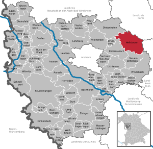
| Location of the city of Heilsbronn in the district of Ansbach | ||
  |
||

Heilsbronn ( colloquially : Glost ə or Glestr ə ) is a town in the Central Franconian district of Ansbach . This is located between Nuremberg and Ansbach in the geographical center of Middle Franconia in the Nuremberg metropolitan region .


geography
The city is located in a wooded valley of the Rangau . The Schwabach rises in the neighboring Ketteldorfer Wald . Neighboring communities are, starting clockwise in the north: Großhabersdorf , Roßtal , Rohr , Windsbach , Neuendettelsau , Petersaurach and Dietenhofen .
Community structure
There are 19 officially named parts of the municipality (the type of settlement is given in brackets ):
|
|
|
The former wastelands Berghof , Schönbühl , Straßenwasen (= Wolfsbrunn), and Ziegelhütte went into the Heilsbronn part of the municipality. In the post-war period, the Werkvolksiedlung and the Lerchenbühl settlement were built.
Neighboring communities
| Dietenhofen | Heilsbronn | Großhabersdorf , Ross Valley |
| Petersaurach |
.svg)
|
pipe |
| Neuendettelsau , Windsbach |
climate
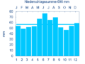
Diagram of precipitation mean values Heilsbronn for the period from 1961 to 1990


In Heilsbronn, the average annual rainfall is 698 mm.
history
Until the church is planted
In the 8th century, the Franconian landlord Hahold founded the place "Haholdesbrunn". According to legend, he had suffered a hunting accident and wandered injured through the forest until he found a spring on the site of the place he subsequently founded, drank from it and recovered. Later the Counts of Abenberg and Knights of Heideck built a chapel. In 1132, Rapoto von Abenberg, with the support of Otto von Bamberg, founded the Cistercian monastery in Heilsbronn as a subsidiary of Ebrach monastery . During this time the colloquial toponym changed from "Haholdesbrunn" and "Haholtisbrunne" (1142) to "Halsbrunn" and at the time of the Cistercian monastery, which existed until 1578, to the Latin Fons salutis (= "fountain of salvation"). The minster of the monastery was the burial place of the Franconian Hohenzollern between 1297 and 1625 . In the middle of the 13th century the monastery was initially under imperial protection, then the Franconian Hohenzollern and Margraves of Ansbach took over the patronage.
In the 17th century, the governor of Neustadt an der Aisch had a certain right of supervision over the Heilsbronn administration (as a monastery office or caste office) .
At the end of the 18th century there were 102 properties in Heilsbronn. The high court was exercised by the Brandenburg-Ansbach caste and city bailiff's office in Windsbach , while the monastery administration office in Heilsbronn held the village and community rulership. All properties had the Heilsbronn monastery administration office as landlord. In addition to the households, there were also ecclesiastical buildings (parish church, rectory, sacristan's house), communal buildings (schoolhouse, shepherd's house, old bath house) and stately buildings (caste master's apartment, office building, etc.).
From 1791 Heilsbronn belonged to the Kingdom of Prussia and often hosted the German Emperor, who gave the Heilsbronn monastery areas such as vineyards in the Main Spessart as thanks. From 1797 to 1808 the place was under the Justice and Chamber Office Windsbach . At that time there were 80 subject families.
19th to 21st century
Heilsbronn has been part of the Kingdom of Bavaria since 1806 .
As part of the municipal edict, the Heilsbronn tax district was formed in 1808 , to which Berghof, Heilsbronn, Schönbühl and Ziegelhütte belonged. The municipality of Heilsbronn was founded in 1810 and was congruent with the tax district. It was subject to the Heilsbronn Regional Court in administration and jurisdiction and the Windsbach Rent Office in the financial administration . From 1862 to 1879 Heilsbronn was administered by the Heilsbronn District Office , since 1880 by the Ansbach District Office (renamed the Ansbach District in 1938 ) and the Heilsbronn Rent Office (1920–1929: Heilsbronn Tax Office , from 1929: Ansbach Tax Office ). The jurisdiction remained with the district court Heilsbronn until 1879, 1880–1956 district court Heilsbronn , since 1956 district court Ansbach .
The main stages of development were the Nuremberg - Heilsbronn - Ansbach railway line, which was newly opened in 1875, as well as the city elevation for the 800th anniversary celebration in 1932 and the incorporation of 16 surrounding villages as part of the municipal reform of 1972/1978 . In 1961 the municipality of Heilsbronn had an area of 3,679 km².
Incorporations
| local community | Residents (1970) |
Incorporation date |
|---|---|---|
| Betzendorf | 162 | January 1, 1972 |
| Bonnhof | 464 | January 1, 1972 |
| Surety | 427 | January 1, 1972 |
| Höfstetten | 139 | May 1, 1978 |
| Chain village | 141 | January 1, 1972 |
| Müncherlbach | 222 | January 1, 1972 |
| Seitendorf | 273 | January 1, 1972 |
| Weissenbronn | 392 | May 1, 1978 |
| Weiterndorf | 207 | April 1, 1971 |
Population development
With 9235 inhabitants (as of 2015) Heilsbronn is the fourth largest municipality and the Heilsbronn district is the fifth largest town in the Ansbach district.
In the period from 1988 to 2018, the population increased from 7,545 to 9,670 by 2,125 inhabitants or by 28.2%.
Heilsbronn municipality
| year | 1987 | 1991 | 1995 | 2000 | 2005 | 2007 | 2008 | 2009 | 2010 | 2011 | 2012 | 2013 | 2014 | 2015 | 2016 | 2017 |
|---|---|---|---|---|---|---|---|---|---|---|---|---|---|---|---|---|
| Residents | 7409 | 8167 | 8882 | 9263 | 9362 | 9205 | 9139 | 9070 | 8999 | 9023 | 9089 | 9145 | 9186 | 9235 | 9347 | 9511 |
| Houses | 1814 | 2435 | 2453 | 2471 | 2471 | |||||||||||
| source |
Heilsbronn district with Berghof, Schönbühl and Ziegelhütte (= Heilsbronn municipality until the regional reform)
| year | 1818 | 1840 | 1852 | 1861 | 1867 | 1871 | 1875 | 1880 | 1885 | 1890 | 1895 | 1900 | 1905 | 1910 | 1919 | 1925 | 1933 | 1939 | 1946 | 1950 | 1961 | 1970 | 1987 | 2016 |
|---|---|---|---|---|---|---|---|---|---|---|---|---|---|---|---|---|---|---|---|---|---|---|---|---|
| Residents | 756 | 863 | 966 | 917 | 996 | 998 | 1165 | 1258 | 1226 | 1234 | 1190 | 1208 | 1290 | 1366 | 1435 | 1550 | 1726 | 2053 | 3316 | 3464 | 4590 | 4920 | 4754 | 6148 |
| Houses | 129 | 130 | 164 | 201 | 198 | 258 | 360 | 708 | 1147 | |||||||||||||||
| source |
politics
City council
The city council has 20 members. The local election on March 15, 2020 led to the following result with a turnout of 61.6% (2014: 60.4%):
mayor
- Jürgen Pfeiffer (CSU) has been the first mayor since May 2008. This was confirmed both in the local election in March 2014 with 71.36% and in the local election in March 2020 with 55.3% of the valid votes in office.
- Second mayor is Gabriele Schaaf (Greens), previously from 2008 to 2020 Carl-Heinz Zischler (SPD).
- The third mayor is Sebastian Buhl (FW), previously from 2008 to 2020 Peter Stemmer (FW).
Former mayors (since the town was raised in 1932):
- Johann Jakob Meyer
- Georg Hofmeister
- Johann Güllich
- Friedrich Hummel
- Johann Kupfer, 1946–1948
- Georg Döllgast, 1948–1958
- Karl Waßner, 1958–1972
- Alfred Knoll, 1972–1984
- Walter Träger (Free Voters), 1984–2008
badges and flags
The municipality of Heilsbronn has had its own coat of arms and flag since 1894.
|
|
Blazon : “Split between gold and red; in front a sloping beam in two rows of red and silver, behind a golden three-bowl fountain; a golden heart on the split line below. "
White and red municipal flag |
| Justification of the coat of arms: The fountain in the community coat of arms comes from the monastery coat of arms from 1525 and stands for the monastery and place name, which was originally derived from the personal name Hahold and was reinterpreted as the "fountain of salvation" after the monastery was founded. The Cistercian bar from the order's coat of arms appears in the split shield . The meaning of the heart is not clear, it appears for the first time in a monastery seal from the late 17th century. |
City partnerships and sponsorships
There are partnerships with
-
 Jößnitz bei Plauen and
 -
 Objat in France .
 -
 Czech Republic : In 1968 the city of Heilsbronn took over the sponsorship of the refugees displaced from the market town of Fleißen and the town of Schnecken due to the Beneš decrees .
Others
From 2004 to 2016 Heilsbronn was part of the municipal alliance (Komm, A) to which the political communities Bruckberg, Dietenhofen, Neuendettelsau, Petersaurach and Windsbach also belonged. Since 2016, the community has been part of the Allianz Kernfranken , which arose from the merger of Komm, A and LiSa (Lichtenau, Sachsen b. Ansbach). The communities of Heilsbronn and Neuendettelsau have been a so-called middle center since 2016 .
Culture and sights
.jpg)
Museums
In the city there are Heimatstuben and a musical instrument museum in the Katharinenturm. The city history museum “From the monastery to the city” is located in the convent house.
Buildings
A striking feature of Heilsbronn is the massive Katharinenturm, which was built from 1770 to 1774 on the foundation walls of the former Katharinenkirche. The minster is the church of the former Heilsbronn monastery . The Cistercian monastery was founded in 1132 by the Counts of Abenberg and was the burial place of the Hohenzollern from 1297 to 1625 . 41 members of the house are buried in the crypt. Steps lead down to a spring that rises in the middle of the church. In the Middle Ages, the monastery had distributed rich possessions all over Franconia as far as Regensburg , and lands in Württemberg also belonged to the monastery.
Economy and Infrastructure
The city is a member of the Nuremberg Metropolitan Region and in the Romantic Franconian Tourist Association.
traffic

About 3 km from Heilsbronn there is a junction with the A 6 / E 50 . The B 14 (part of the Burgenstrasse ) is a bypass around the city. Heilsbronn station is located in the north of the main town on the Nuremberg – Crailsheim railway line and is served by the S4 S-Bahn line in the Greater Nuremberg Transport Association . Some bus routes to neighboring communities start and end at the train station.
The State Road 2410 leads to Aich or Bonnhof . The district road AN 17 leads to Weißenbronn or to Ketteldorf . Communal roads lead to Aich, Butzenhof , Gottmannsdorf and Weiterndorf .
The Hohenzollernweg, a 30 km long bike path, leads from Heilsbronn to Cadolzburg . The Franconian Marienweg runs through Heilsbronn .
Resident companies (selection)
- acad group, acad prototyping GmbH (development and production of small and start-up series as well as plastic injection molding)
- FEGA & Schmitt Elektrogroßhandel (electrical wholesalers, part of the Würth Group )
- Gebr. Fleischmann GmbH & Co. KG (model railway)
- Hans Kupfer & Sohn GmbH & Co. KG (meat and sausage products)
- Maschinenbau Heilsbronn GmbH
- NBHX Trim GmbH, formerly: IPG Industrieplast GmbH (automotive supplier)
- Ortlieb Sportartikel GmbH (packing bags)
- Polyden Folienfabrik GmbH (film production)
- ZZ Kunststoff GmbH (plastic parts and Zeppelin models)
media
The only regional daily newspaper that appears in the area of the city of Heilsbronn is the Fränkische Landeszeitung (publishing house: Ansbach).
The monthly newspaper and the monthly Habewind-News - Our Franconian homeland as well as the weekly advertising papers Woche im Blick (WiB) and Wochenzeitung (WZ) are distributed free of charge to every household.
The regional radio station Radio 8 from Ansbach can be received on a frequency of 89.4 MHz.
Public facilities
- Religious Education Center (RPZ) of the Evang.-Luth. Regional Church in Bavaria (formerly: Institute for Teacher Training and Catechetical Office)
- Office for Food, Agriculture and Forestry - Heilsbronn Office (for the forestry sector)
- Police Inspection Heilsbronn, an office of the Police Headquarters Middle Franconia of the Bavarian Police in Nuremberg
- Heilsbronn Youth Center, public institution that serves to maintain contacts for young people. In this facility, among other things, performances by young music groups take place.
education
- Bürglein primary school (part of the municipality of Heilsbronn)
- Heilsbronn primary school
- Markgraf-Georg-Friedrich- Realschule Heilsbronn
The main school building was taken over by the Realschule, the closest middle school is in Petersaurach .
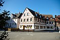
Gasthof Zum Löwen on the market square

Markgraf-Georg-Friedrich-Realschule

War memorial in the city cemetery


Personalities
Honorary citizen
- Johann Ludwig Kammerecker (1864–1945), Privy Court and Commerce Councilor, honorary citizen from 1911
sons and daughters of the town
- Johann III. von Eych (* 1404 in Eych near Heilsbronn), 50th diocesan and prince-bishop of Eichstätt
- Barbara Hedlerin , indicted in a witch trial at the time of the witch hunts in 1592
- Hans Schmidt (1902–1982), composer, music teacher and conductor
- Hermann Skarke (1931–2019), chess player
Personalities who have worked in the city
- Caspar Othmayr (1515–1553), composer, rector of the monastery school
- Konrad Limmer (1522–1592), from 1578 abbot in Heilsbronn Monastery
- Basilius von Ramdohr (1757–1822), lawyer and diplomat, founded the restoration of the convent house in 1816
- Friedrich Mergner (1818–1891), pastor in Heilsbronn from 1884
literature
- Johann Kaspar Bundschuh : Heilsbronn . In: Geographical Statistical-Topographical Lexicon of Franconia . tape 2 : El-H . Verlag der Stettinische Buchhandlung, Ulm 1800, DNB 790364298 , OCLC 833753081 , Sp. 553-555 ( digitized version ).
- Elisabeth Fechter: The place names of the district of Ansbach . Inaugural dissertation. Erlangen 1955, DNB 480570132 , p. 207 .
- Günther P. Fehring : City and district of Ansbach (= Bavarian art monuments . Volume 2 ). Deutscher Kunstverlag, Munich 1958, DNB 451224701 , p. 100-114 .
- Johann Bernhard Fischer : Heilsbronn . In: Statistical and topographical description of the Burggraftum Nürnberg, below the mountain, or the Principality of Brandenburg-Anspach. Second part. Containing the economic, statistical and moral condition of these countries according to the fifteen upper offices . Benedict Friedrich Haueisen, Ansbach 1790, p. 410-419 ( digitized version ).
- Johannes Hung: Heilsbronn in old views. Zaltbommel, Europ. Library, 1992.
- Johannes Hung: From the house chronicle of Heilsbronn: Klostermühle and administrator's house. In: Yearbook of the Historical Association for Middle Franconia. Ansbach 1993 - ISSN 0341-9339 . - 96. 1992/1993, pp. 231-238.
- Johannes Hung: The medical, topographical and ethnographical description of the district court district Heilsbronn by the royal court doctor Dr. Ebersberger 1860. 1989.
- Manfred Jehle: Ansbach: the margravial chief offices Ansbach, Colmberg-Leutershausen, Windsbach, the Nuremberg nursing office Lichtenau and the Deutschordensamt (Wolframs-) Eschenbach (= historical atlas of Bavaria, part Franconia . I, 35). Commission for Bavarian State History, Munich 2009, ISBN 978-3-7696-6856-8 .
- Adolf Lang (Ed.): Heilsbronn: The Franconian Munster City . Heilsbronn 1982.
- Wolf-Armin von Reitzenstein : Lexicon of Franconian place names. Origin and meaning . Upper Franconia, Middle Franconia, Lower Franconia. CH Beck, Munich 2009, ISBN 978-3-406-59131-0 , p. 97-98 .
- Konrad Rosenhauer et al. (Ed.): The district of Ansbach. Past and present . Publishing house for authorities and business Hoeppner, Aßling-Pörsdorf 1964, DNB 450093387 , p. 147-151 .
- Gottfried Stieber: Hailsbronn . In: Historical and topographical news from the Principality of Brandenburg-Onolzbach . Johann Jacob Enderes, Schwabach 1761, p. 434-451 ( digitized version ).
- Pleikard Joseph Stumpf : Heilsbronn . In: Bavaria: a geographical-statistical-historical handbook of the kingdom; for the Bavarian people . Second part. Munich 1853, p. 727 f . ( f # v = onepage & q & f = false digitized ).
Web links
Individual evidence
- ↑ "Data 2" sheet, Statistical Report A1200C 202041 Population of the municipalities, districts and administrative districts 1st quarter 2020 (population based on the 2011 census) ( help ).
- ↑ E. Fechter, p. 94.
- ^ Heilsbronn community in the local database of the Bavarian State Library Online . Bavarian State Library, accessed on September 14, 2019.
- ↑ Was first listed as a part of the municipality in 1818, no longer after 1925.
- ↑ Was first listed as a community part in 1818 (alternatively also called Fallhaus ), no longer after 1885.
- ↑ Was first listed as a part of the municipality in 1846, no longer after 1875.
- ↑ Was first listed as a part of the municipality in 1818, no longer after 1875.
- ↑ Latin language relics in the Bavarian dialek. Place names .
- ↑ W.-A. v. Reitzenstein, p. 97 f.
- ↑ Gravege of the margraves on the website of the Franconian Alb Association
- ↑ Lexicon for Theology and Church . Volume 4, Col. 900.
- ^ Max Döllner : History of the development of the city of Neustadt an der Aisch up to 1933. Ph. C. W. Schmidt, Neustadt a. d. Aisch 1950, OCLC 42823280 ; New edition to mark the 150th anniversary of the Ph. C. W. Schmidt publishing house, Neustadt an der Aisch 1828–1978. Ibid 1978, ISBN 3-87707-013-2 , p. 108.
- ↑ M. Jehle, Vol. 2, p. 866.
- ^ Johann Bernhard Fischer : Heilsbronn . In: Statistical and topographical description of the Burggraftum Nürnberg, below the mountain, or the Principality of Brandenburg-Anspach. Second part. Containing the economic, statistical and moral condition of these countries according to the fifteen upper offices . Benedict Friedrich Haueisen, Ansbach 1790, p. 406 ( digitized version ).
- ↑ State Archive Nuremberg, Government of Middle Franconia, Chamber of the Inner Tax 1952, 3850: Formation of the municipal and rural communities in the Heilsbronn district court in 1810. Quoted from M. Jehle, vol. 2, p. 963.
- ^ Address and statistical manual for the Rezatkreis in the Kingdom of Baiern . Buchdruckerei Chancellery, Ansbach 1820, p. 43 ( digitized version ).
- ↑ M. Jehle, Vol. 2, p. 993 f.
- ^ Wilhelm Volkert (ed.): Handbook of Bavarian offices, communities and courts 1799–1980 . CH Beck, Munich 1983, ISBN 3-406-09669-7 , p. 421 .
- ↑ a b Bavarian State Statistical Office (ed.): Official city directory for Bavaria, territorial status on October 1, 1964 with statistical information from the 1961 census . Issue 260 of the articles on Bavaria's statistics. Munich 1964, DNB 453660959 , Section II, Sp. 755 ( digitized version ).
- ↑ a b Only inhabited houses are given. In 1818 these were referred to as hearths , in 1840 as houses and from 1871 to 2016 as residential buildings.
- ↑ a b Bavarian State Office for Statistics and Data Processing (Ed.): Official local directory for Bavaria, territorial status: May 25, 1987 . Issue 450 of the articles on Bavaria's statistics. Munich November 1991, DNB 94240937X , p. 327 f . ( Digitized version ).
- ↑ a b c d e f g h i j Heilsbronn: Official statistics of the LfStat
- ↑ Alphabetical index of all the localities contained in the Rezatkkreis according to its constitution by the newest organization: with indication of a. the tax districts, b. Judicial Districts, c. Rent offices in which they are located, then several other statistical notes . Ansbach 1818, p. 38 ( digitized version ). For the municipality of Heilsbronn plus the residents and buildings of Berghof (p. 9), Schönbühl (p. 83) and Ziegelhütte (p. 106).
- ↑ Eduard Vetter (Ed.): Statistical handbook and address book of Middle Franconia in the Kingdom of Bavaria . Self-published, Ansbach 1846, p. 143-144 ( digitized version ).
- ↑ Bavarian State Statistical Office (Hrsg.): Historical municipality register: The population of the municipalities of Bavaria in the period from 1840 to 1952 (= contributions to Statistics Bavaria . Issue 192). Munich 1954, DNB 451478568 , p. 174 , urn : nbn: de: bvb: 12-bsb00066439-3 ( digitized version ).
- ^ Joseph Heyberger, Chr. Schmitt, v. Wachter: Topographical-statistical manual of the Kingdom of Bavaria with an alphabetical local dictionary . In: K. Bayer. Statistical Bureau (Ed.): Bavaria. Regional and folklore of the Kingdom of Bavaria . tape 5 . Literary and artistic establishment of the JG Cotta'schen Buchhandlung, Munich 1867, Sp. 1042 , urn : nbn: de: bvb: 12-bsb10374496-4 ( digitized version ).
- ↑ Kgl. Statistisches Bureau (Ed.): Directory of the municipalities of the Kingdom of Bavaria according to the status of the population in December 1867 . XXI. Issue of the contributions to the statistics of the Kingdom of Bavaria. Ackermann, Munich 1869, p. 164 ( digitized version ).
- ↑ Kgl. Statistical Bureau (ed.): Complete list of localities of the Kingdom of Bavaria. According to districts, administrative districts, court districts and municipalities, including parish, school and post office affiliation ... with an alphabetical general register containing the population according to the results of the census of December 1, 1875 . Adolf Ackermann, Munich 1877, 2nd section (population figures from 1871, cattle figures from 1873), Sp. 1207–1208 , urn : nbn: de: bvb: 12-bsb00052489-4 ( digitized version ).
- ↑ K. Bayer. Statistical Bureau (ed.): Community directory for the Kingdom of Bavaria. Manufactured due to the new organization of government districts, district offices and judicial districts. Addendum to issue 36 of the articles on Bavaria's statistics. Munich 1879, p. 61 ( digitized version ).
- ↑ K. Bayer. Statistical Bureau (ed.): Community directory for the Kingdom of Bavaria. Results of the census of December 1, 1880. Issue 35 of the articles on Bavaria's statistics. Munich 1882, p. 174 ( digitized version ).
- ↑ K. Bayer. Statistical Bureau (Ed.): Localities directory of the Kingdom of Bavaria. According to government districts, administrative districts, ... then with an alphabetical register of locations, including the property and the responsible administrative district for each location. LIV. Issue of the contributions to the statistics of the Kingdom of Bavaria. Munich 1888, Section III, Sp. 1094 ( digitized version ).
- ↑ a b c d e f g h Bavarian State Statistical Office (Hrsg.): Historical municipality register: The population of the municipalities of Bavaria from 1840 to 1952 (= contributions to Statistics Bavaria . Issue 192). Munich 1954, DNB 451478568 , p. 164 , urn : nbn: de: bvb: 12-bsb00066439-3 ( digitized version ).
- ↑ K. Bayer. Statistical Bureau (Ed.): Directory of localities of the Kingdom of Bavaria, with alphabetical register of places . LXV. Issue of the contributions to the statistics of the Kingdom of Bavaria. Munich 1904, Section II, Sp. 1159 ( digitized version ).
- ↑ Bavarian State Statistical Office (ed.): Localities directory for the Free State of Bavaria according to the census of June 16, 1925 and the territorial status of January 1, 1928 . Issue 109 of the articles on Bavaria's statistics. Munich 1928, Section II, Sp. 1196 ( digitized version ).
- ↑ Bavarian State Statistical Office (ed.): Official place directory for Bavaria - edited on the basis of the census of September 13, 1950 . Issue 169 of the articles on Bavaria's statistics. Munich 1952, DNB 453660975 , Section II, Sp. 1026 ( digitized version ).
- ^ Bavarian State Statistical Office (ed.): Official place directory for Bavaria . Issue 335 of the articles on Bavaria's statistics. Munich 1973, DNB 740801384 , p. 170 ( digitized version ).
- ↑ www.heilsbronn.de
- ↑ Mayor. Heilsbronn municipality, accessed on August 15, 2020 .
- ↑ election results
- ^ Entry on the coat of arms of Heilsbronn in the database of the House of Bavarian History
- ↑ Heilsbronn. In: Kommunalflaggen.eu. Retrieved February 6, 2020 .
- ↑ www.kernfranken.eu

Adelshofen | Arberg | Aurach | Bechhofen | Bruckberg | Book at the forest | Burgoberbach | Burk | Colmberg | Dentlein am Forst | Diebach | Dietenhofen | Dinkelsbühl | Dombühl | Dürrwangen | Ehingen | Feuchtwangen | Flachslanden | Gebsattel | Gerolfingen | Geslau | Heilsbronn | Herrieden | Insingen | Langfurth | Lehrberg | Leutershausen | Lichtenau | Merkendorf | Mitteleschenbach | Mönchsroth | Neuendettelsau | Neusitz | Oberdachstetten | Ohrbach | Ornbau | Petersaurach | Röckingen | Rothenburg ob der Tauber | Rügland | Saxony near Ansbach | Schillingsfürst | Schnelldorf | Schopfloch | Steinsfeld | Unterschwaningen | Wassertrüdingen | Weidenbach | Weihenzell | Weiltingen | Wettringen | Wieseth | Wilburgstetten | Windelsbach | Windsbach | Wittelshofen | Wolframs-Eschenbach | Wörnitz
Unregulated areas:
Lower Forest