
Cadolzburg
| coat of arms | Germany map | |
|---|---|---|

|
Coordinates: 49 ° 27 ' N , 10 ° 52' E |
|
| Basic data | ||
| State : | Bavaria | |
| Administrative region : | Middle Franconia | |
| County : | Fuerth | |
| Height : | 364 m above sea level NHN | |
| Area : | 45.42 km 2 | |
| Residents: | 11,249 (Dec. 31, 2019) | |
| Population density : | 248 inhabitants per km 2 | |
| Postal code : | 90556 | |
| Area code : | 09103 | |
| License plate : | FÜ | |
| Community key : | 09 5 73 114 | |
| LOCODE : | DE CAO | |
| Market structure: | 16 parts of the community | |
Market administration address : |
Rathausplatz 1 90556 Cadolzburg |
|
| Website : | ||
| First Mayor : | Bernd Obst ( CSU ) | |
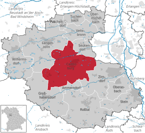
| Location of the Cadolzburg market in the Fürth district | ||
  |
||


.jpg)
Cadolzburg (also outdated Kadolzburg ; colloquially "Sporch", spoken [ ʃbɔrχ ], or "Kalschbuʳch") is a market in the central Franconian district of Fürth . The castle, first mentioned in 1157, is named after it and is centrally located .
geography
Geographical location
The place is about eight kilometers west of Fürth . The topography shows considerable differences in height.
Neighboring communities
The neighboring municipalities are: (starting in the north in a clockwise direction)
Community structure
There are 16 officially named municipal parts (the type of settlement is given in brackets ):
|
|
|
history
middle Ages
The place was first mentioned in 1157 when the Vogt of Kadolzburg, a "Helmericus de Kadoldesburc" agreed to an exchange of goods between the diocese of Würzburg and the monastery of Heilsbronn . The place name can be explained as Kadolds Burg (Castle of Kadold). If it goes back to Count Kadold, who founded the Herrieden monastery around 793 , it would have been an early medieval fortification from the 8th century. It is more likely that it emerged from an allodial rule of the Abenbergs in the early 11th century . However, nothing has survived from this early period. The oldest known structures of the castle were built around 1250 under the Hohenzollern , the Nuremberg burgrave Konrad I and his son Friedrich III. when they expanded Cadolzburg into their residence. In 1397 Friedrich VI. the "lower mountain" land with the Cadolzburg residence was allocated. 20 years later he received the electoral dignity of Brandenburg and became the ancestor of the Prussian kings and the German emperors since 1871. Under his son Albrecht Achilles of Brandenburg, the Cadolzburg became a hunting residence. In the middle of the 14th century the spelling "Cadelspurgk" of the place name was common and appears in numerous imperial city documents of Nuremberg. As part of the Margraviate of Ansbach, the place was in the Franconian Empire from 1500 .
Modern times
During the Thirty Years' War , the place was heavily looted in autumn 1631. At the end of the 18th century there were around 120 properties in Cadolzburg. The high court and the village and community rule exercised the Brandenburg-Ansbach Oberamt Cadolzburg . The landlords were the Cadolzburg box office (castle, game master's apartment, 2 gatehouses, brewery, 2 blacksmiths, bath room, 2 taverns, 2 half courtyards, 105 houses, 1 brickworks) and the parish of Cadolzburg (2 estates).
As part of the municipal edict, the Cadolzburg tax district was formed in 1808 . In 1810 the municipality of Cadolzburg was founded, which was congruent with the tax district. She was in administration and jurisdiction of the district court Cadolzburg and in the financial administration of the bursary Cadolzburg (in 1920 the tax office Cadolzburg renamed). In 1818 Cadolzburg became a market with Magistrate III. Class appointed. From 1862 Cadolzburg was subordinate to the district office of Fürth (renamed the district of Fürth in 1938 ). Jurisdiction remained with the Cadolzburg District Court until 1879, from 1880 to March 1, 1931 it was with the Cadolzburg District Court , since then it has been exercised by the Fürth District Court . Since January 1, 1929, the financial administration has been under the Fürth tax office . In 1961 the municipality had an area of 4.486 km².
Incorporations
On January 1, 1972, most of the Deberndorf community was incorporated, and the then Roßendorf community was added on July 1, 1972. On May 1, 1978 Steinbach and the community part of Seckendorf followed the dissolved community of Horbach .
Population development
Cadolzburg community
| year | 1987 | 2007 | 2008 | 2009 | 2010 | 2011 | 2012 | 2013 | 2014 | 2015 | 2016 | 2017 |
|---|---|---|---|---|---|---|---|---|---|---|---|---|
| Residents | 8003 | 10130 | 10180 | 10224 | 10297 | 10323 | 10392 | 10470 | 10683 | 10741 | 10976 | 11073 |
| Houses | 2052 | 3100 | 3168 | 3197 | 3221 | |||||||
| source |
Part of the municipality of Cadolzburg (= municipality of Cadolzburg until the regional reform)
| year | 1818 | 1840 | 1852 | 1855 | 1861 | 1867 | 1871 | 1875 | 1880 | 1885 | 1890 | 1895 | 1900 | 1905 | 1910 | 1919 | 1925 | 1933 | 1939 | 1946 | 1950 | 1952 | 1961 | 1970 | 1987 |
|---|---|---|---|---|---|---|---|---|---|---|---|---|---|---|---|---|---|---|---|---|---|---|---|---|---|
| Residents | 976 | 1298 | 1333 | 1342 | 1344 | 1345 | 1319 | 1285 | 1237 | 1227 | 1280 | 1417 | 1494 | 1584 | 1655 | 1747 | 1870 | 2025 | 2215 | 3160 | 3309 | 3296 | 3480 | 3811 | 4257 |
| Houses | 136 | 165 | 212 | 216 | 239 | 300 | 388 | 554 | 1059 | ||||||||||||||||
| source |
politics

Market council
Until 2002, the municipal council had 20 members, and since the local elections in 2008 there have been 24.
| CSU / FWG | SPD | Green | PWG | Free voters | BfC | The left | total | |
| 2002 | 8th | 8th | 1 | 2 | 1 | - | - | 20 seats |
| 2008 | 12 | 6th | 1 | 4th | 1 | - | - | 24 seats |
| 2014 | 11 | 6th | 2 | 3 | 2 | - | - | 24 seats |
| 2020 | 10 | 4th | 4th | - | 4th | 1 | 1 | 24 seats |
| 42.5% | 17.3% | 16.4% | 17.6% | 3.6% | 2.7% | Elective 65% |
In 2020 the FW (Free Voters) cooperated with the PWG (Non-Party Voting Association Cadolzburg). The CSU has been running together with the FWG (Free Voting Association Cadolzburg) for a long time.
For the 2020 local election, Die Linke and the BfC (Citizens for Cadolzburg) moved into the local council for the first time.
mayor
Claus Pierer (SPD) was in office from 1978 to 2002, followed by Bernd Obst (CSU). On March 2, 2008 he was re-elected with 79% of the votes against Hermann Zempel (SPD) with 21%. On March 16, 2014, Obst was confirmed in office with 76% of the votes; Diana Eichhorn (SPD) stood against him, who received 24% of the votes. For the 2020 local elections, incumbent Obst stood together for the CSU and FWG. He was able to prevail against Angelika Abram (SPD) with 79%.
badges and flags
|
|
Blazon : "In green a growing golden stag , between its poles a jumping silver hound ."
Green, white and yellow municipal flag |
| Foundation of the coat of arms: The first seals are documented from the 15th century; According to the legend, they were court seals. Even in the oldest prints, the stag and the hound were in the shield, which temporarily also showed the castle-count's border of silver and red. The bracke has been the burgrave's helmet since 1317 and indicates their rule. The meaning of the deer is unclear. The field color green has been used since the 19th century. At Hupp's, the stag is red. |
Community partnerships
The partner communities are:
-
 : Le Palais-sur-Vienne in western France
-
 : Mauterndorf in Austria ( Land Salzburg )
 -
 : Ulten in South Tyrol
Culture and sights
Buildings
Castle


The namesake of the market first mentioned in 1388 was the Cadolzburg, first mentioned in 1157. The current building stock of the castle complex dates from the 13th to the 18th century. From 1260 the Cadolzburg served as the seat of the Hohenzollern burgraves of Nuremberg . Elector Friedrich I of Brandenburg fundamentally rebuilt the castle. He died there in 1440. He donated the Cadolzburg Altar from 1420/25 to the parish church dedicated to St. Cäcilie . At the foot of the crucifixion scene on the central panel, he is shown together with his wife Elisabeth von Bayern-Landshut as the donor couple . The side wings show St. Cecilia, the church patroness, and her bridegroom, St. Valerian . The three-winged altar , now kept in the Grunewald Hunting Lodge in Berlin , was given to the Prussian Crown Prince Friedrich III in 1873 at his request . as a gift and has since been replaced by a true-to-original copy. The castle remained intact during the Thirty Years' War.
1933–1945 a part of the castle, the so-called New Palace, was used by the Hitler Youth as a regional leadership school. At the end of the Second World War in 1945, the castle went up in flames and remained in ruins for decades. Since 1979 the Bavarian Palace Administration has been entrusted with the reconstruction in cooperation with the Erlangen-Nuremberg State Building Authority. The reconstruction of the main castle, which began in 1982, was provisionally completed in 2007 with the repair and partial redesign of the outdoor facilities by the Wiegel landscape architecture firm. In the period that followed, the areas in the Old and New Palace, the inner courtyard and the outer bailey were available for numerous public events.
In 2013 the decision was made to completely expand the old castle and a building in the outer bailey into an adventure museum. In June 2017 the new museum became HerrschaftsZeiten. Cadolzburg experience opened.
In front of the main castle to the south is a generously dimensioned outer castle, mainly with buildings from the 17th and 18th centuries, as well as a walled pleasure garden area. The gate tower with the clock tower is a Gothic component (13th / 14th century).
Observation tower

The 25 meter high observation tower (colloquially “pencil”) was built in a high place in the town in 1893 by the local railway company (LAG) Munich in a neo-Gothic style to encourage excursion traffic to Cadolzburg.
In clear weather it offers a far-reaching all-round view. It used to be a popular excursion destination, especially for the people of Fürth, who took the train to Cadolzburg on weekends or especially when the cherry trees are in bloom ("in the Bläih"). A square wooden staircase leads up five floors. About halfway up there is a small balcony on one side of the tower, accessible through a wooden door. Slightly tapered in the upper part, the roofed viewing platform protrudes over consoles . The top is formed by a spire with four decoratively protruding windows on each side. The tower can be visited for a donation and is generally open from sunrise to sunset without guarding.
Other structures
The Evangelical Lutheran Parish Church ( Margrave Church ) St. Cäcilia was built in 1750/51 in classicist Baroque forms as a hall building over a probably Gothic predecessor building. The interior is determined by a circumferential gallery with an altar wall in the east and the organ in the west. The baptismal font comes from the baroque new building phase (dated 1751). The crucifixion group from the circle of Veit Stoss , which was probably composed later from late Gothic wood-carved figures, is remarkable ; Maria and Johannes probably from 1470/80, the crucifix around 1500.
The former city wall from the 15th century has largely been preserved; on the gate tower you can find the inscribed date "1476".
Architectural monuments
Local museum
In the former town hall , built in 1668 , the Heimatverein established the Rangau Heimathaus. In twelve rooms there is an overview of the history of Cadolzburg and the geology of the region.
Economy and Infrastructure
traffic
The national road 2409 , a connection between the national highway 14 at Rosstal with the national road 8 in Seukendorf , crosses the municipality from south to north. The district road FÜ 19 runs east to Wachendorf and southwest to Zautendorf . The FÜ 2 runs north via Seckendorf to a junction of the B 8. The FÜ 16 runs west to Roßendorf . Communal roads lead to Egersdorf , Gonnersdorf , Greimersdorf and Steinbach .
In the first half of the 1880s, Cadolzburg was connected to the Nuremberg-Crailsheimer Railway by stagecoach via Großhabersdorf in Heilsbronn . This lost its importance when the Rangau Railway was extended to Cadolzburg on October 14, 1892, via the then terminus Zirndorf. For a short time, a continuation via Deberndorf and Seubersdorf to Unterstbibert was under discussion in order to open up the quarries on Dillenberg near Deberndorf by rail. The Lokalbahn Aktien-Gesellschaft rejected this on February 1, 1894 because of the "unfavorable terrain".
Lines 136 and 152 of the Greater Nuremberg Transport Association meet at Cadolzburg train station . While the 136 line is mainly used as a school bus for the Ammerndorfer and Cadolzburg students at the Wolfgang Borchert grammar school in Langenzenn, the 152 line opens up the towns around the Dillenberg and provides a connection to the Dietrich Bonhoeffer grammar school in Oberasbach , the Zirndorf state secondary school and to the city of Fürth.
In the evenings and on weekends, the train station is the destination of the collective taxi from the Cadolzburg suburbs.
In April 2016, a referendum took place on a possible bypass for Cadolzburg. However, this was rejected by a majority of 69.61%.
Established businesses
- Cadolto, a manufacturer of container buildings
- Riegelein chocolate factory, founded in 1953
Public facilities
- The Heart Youth Center in Cadolzburg
societies
TSV Cadolzburg: The soccer department, by far the largest department of TSV, comprises eleven teams that can play on three large fields and one small field.
Personalities
- Johann Georg Pisendel (1687–1755), violinist and composer
- Georg Friedrich Puchta (1798–1846), lawyer
- Ludwig Keller (1839–1911), lawyer and politician
- August Ortloph (1882–1964), German fire department functionary
- Roland Rosenbauer (* 1956), journalist, writer and translator
literature
- Kadolzburg . In: Meyers Konversations-Lexikon . 4th edition. Volume 9, Verlag des Bibliographisches Institut, Leipzig / Vienna 1885–1892, p. 352.
- Johann Kaspar Bundschuh : Cadolzburg . In: Geographical Statistical-Topographical Lexicon of Franconia . tape 1 : A-egg . Verlag der Stettinische Buchhandlung, Ulm 1799, DNB 790364298 , OCLC 833753073 , Sp. 520-525 ( digitized version ).
- Daniel Burger : The Cadolzburg - dynasty castle of the Hohenzollern and margravial official seat . In: Scientific supplements to the display of the Germanisches Nationalmuseum (24). Research on castles and palaces - special volume (1) . tape 24 . Verlag des Germanisches Nationalmuseums , Nuremberg 2005, ISBN 978-3-936688-05-4 , doi : 10.11588 / arthistoricum.397 (216 pages).
- Daniel Burger, Birgit Friedel: Castles and palaces in Middle Franconia . ars vivendi Verlag, Cadolzburg 2003, ISBN 3-89716-379-9 , p. 229-233 .
- August Gebeßler : City and District of Fürth (= Bavarian Art Monuments . Volume 18 ). Deutscher Kunstverlag, Munich 1963, DNB 451450957 , p. 77-93 .
- Hanns Hubert Hofmann : Nuremberg-Fürth (= Historical Atlas of Bavaria, part Franconia I, 4). Commission for Bavarian State History, Munich 1954, DNB 452071224 , p. 107 ( digitized version ). Ibid. S. 227 ( digitized version ).
- Wolf-Armin von Reitzenstein : Lexicon of Franconian place names. Origin and meaning . Upper Franconia, Middle Franconia, Lower Franconia. CH Beck, Munich 2009, ISBN 978-3-406-59131-0 , p. 49 .
- Hans-Günter Richardi : Castles in Bavaria - A romantic guide to 60 castles . Süddeutscher Verlag , Munich 1973, ISBN 3-7991-5731-X , p. 103-105 .
- Gottfried Stieber: Cadolzburg . In: Historical and topographical news from the Principality of Brandenburg-Onolzbach . Johann Jacob Enderes, Schwabach 1761, p. 273-279 ( digitized version ).
- Pleikard Joseph Stumpf : Cadolzburg . In: Bavaria: a geographical-statistical-historical handbook of the kingdom; for the Bavarian people . Second part. Munich 1853, p. 699 ( digitized version ).
- Wolfgang Wiessner: City and District of Fürth (= Historical Place Name Book of Bavaria, Middle Franconia . Volume 1 ). Commission for Bavarian State History, Munich 1963, DNB 455524629 , p. 21-23 .
- Extensive literature collection in the FürthWiki zu Cadolzburg
Web links
- Cadolzburg market administration
- Cadolzburg: Official statistics of the LfStat
- Cadolzburg in the Topographia Franconiae of the University of Würzburg , accessed on September 21, 2019.
- Pictures from Cadolzburg and the surrounding area (private; Erich Rück)
Individual evidence
- ↑ "Data 2" sheet, Statistical Report A1200C 202041 Population of the municipalities, districts and administrative districts 1st quarter 2020 (population based on the 2011 census) ( help ).
- ↑ Mandate holder :. Cadolzburg community, accessed on June 5, 2020 .
- ↑ W. Wiessner, p. 21.
- ^ Municipality of Cadolzburg in the local database of the Bavarian State Library Online . Bavarian State Library, accessed on September 21, 2019.
- ↑ W. Wiessner, p. 21; W.-A. v. Reitzenstein, p. 49.
- ^ Max Döllner : History of the development of the city of Neustadt an der Aisch up to 1933. Ph. C. W. Schmidt, Neustadt a. d. Aisch 1950, OCLC 42823280 ; New edition to mark the 150th anniversary of the Ph. C. W. Schmidt publishing house, Neustadt an der Aisch 1828–1978. Ibid 1978, ISBN 3-87707-013-2 , p. 237.
- ↑ HH Hofmann, p. 107.
- ↑ HH Hofmann, p. 227; Address and statistical handbook for the Rezatkreis in the Kingdom of Baiern . Buchdruckerei Chancellery, Ansbach 1820, p. 27 ( digitized version ).
- ↑ a b Bavarian State Statistical Office (ed.): Official city directory for Bavaria, territorial status on October 1, 1964 with statistical information from the 1961 census . Issue 260 of the articles on Bavaria's statistics. Munich 1964, DNB 453660959 , Section II, Sp. 779 ( digitized version ).
- ^ Wilhelm Volkert (ed.): Handbook of Bavarian offices, communities and courts 1799–1980 . CH Beck, Munich 1983, ISBN 3-406-09669-7 , p. 467 .
- ^ Federal Statistical Office (ed.): Historical municipality directory for the Federal Republic of Germany. Name, border and key number changes in municipalities, counties and administrative districts from May 27, 1970 to December 31, 1982 . W. Kohlhammer, Stuttgart / Mainz 1983, ISBN 3-17-003263-1 , p. 714 .
- ↑ a b Only inhabited houses are given. In 1818 these were referred to as hearths , in 1840 as houses and from 1871 to 2017 as residential buildings.
- ↑ a b Bavarian State Office for Statistics and Data Processing (Ed.): Official local directory for Bavaria, territorial status: May 25, 1987 . Issue 450 of the articles on Bavaria's statistics. Munich November 1991, DNB 94240937X , p. 336 ( digitized version ).
- ↑ a b c d e f g h i j k Cadolzburg: Official statistics of the LfStat
- ↑ Alphabetical index of all the localities contained in the Rezatkkreis according to its constitution by the newest organization: with indication of a. the tax districts, b. Judicial Districts, c. Rent offices in which they are located, then several other statistical notes . Ansbach 1818, p. 16 ( digitized version ).
- ↑ Eduard Vetter (Ed.): Statistical handbook and address book of Middle Franconia in the Kingdom of Bavaria . Self-published, Ansbach 1846, p. 64 ( digitized version ). Cadolzburg: 1293 inhabitants, 164 houses; Fallhaus: 5 E., 1 H. According to the historical municipality register , the municipality had 1301 inhabitants.
- ↑ a b c d e f g h i j k l m n Bavarian State Statistical Office (Hrsg.): Historical municipality register: The population of the municipalities of Bavaria from 1840 to 1952 (= contributions to Statistics Bavaria . Issue 192). Munich 1954, DNB 451478568 , p. 172 , urn : nbn: de: bvb: 12-bsb00066439-3 ( digitized version ).
- ^ Joseph Heyberger, Chr. Schmitt, v. Wachter: Topographical-statistical manual of the Kingdom of Bavaria with an alphabetical local dictionary . In: K. Bayer. Statistical Bureau (Ed.): Bavaria. Regional and folklore of the Kingdom of Bavaria . tape 5 . Literary and artistic establishment of the JG Cotta'schen Buchhandlung, Munich 1867, Sp. 1029 , urn : nbn: de: bvb: 12-bsb10374496-4 ( digitized version ).
- ↑ Kgl. Statistical Bureau (ed.): Complete list of localities of the Kingdom of Bavaria. According to districts, administrative districts, court districts and municipalities, including parish, school and post office affiliation ... with an alphabetical general register containing the population according to the results of the census of December 1, 1875 . Adolf Ackermann, Munich 1877, 2nd section (population figures from 1871, cattle figures from 1873), Sp. 1194–1195 , urn : nbn: de: bvb: 12-bsb00052489-4 ( digital copy ). Cadolzburg: 1312 inhabitants; Fall Mastery: 7 E.
- ↑ K. Bayer. Statistical Bureau (Ed.): Localities directory of the Kingdom of Bavaria. According to government districts, administrative districts, ... then with an alphabetical register of locations, including the property and the responsible administrative district for each location. LIV. Issue of the contributions to the statistics of the Kingdom of Bavaria. Munich 1888, Section III, Sp. 1125 ( digitized version ). Cadolzburg: 1218 inhabitants, 215 residential buildings; Fallmeisterei: 9 E., 1 Wgb.
- ↑ K. Bayer. Statistical Bureau (Ed.): Directory of localities of the Kingdom of Bavaria, with alphabetical register of places . LXV. Issue of the contributions to the statistics of the Kingdom of Bavaria. Munich 1904, Section II, Sp. 1193 ( digitized version ).
- ↑ Bavarian State Statistical Office (ed.): Localities directory for the Free State of Bavaria according to the census of June 16, 1925 and the territorial status of January 1, 1928 . Issue 109 of the articles on Bavaria's statistics. Munich 1928, Section II, Sp. 1230 ( digitized version ).
- ↑ Bavarian State Statistical Office (ed.): Official place directory for Bavaria - edited on the basis of the census of September 13, 1950 . Issue 169 of the articles on Bavaria's statistics. Munich 1952, DNB 453660975 , Section II, Sp. 1061 ( digitized version ).
- ^ Bavarian State Statistical Office (ed.): Official place directory for Bavaria . Issue 335 of the articles on Bavaria's statistics. Munich 1973, DNB 740801384 , p. 174 ( digitized version ).
- ↑ Election of the municipal council - municipal elections 2020 in the Cadolzburg market - overall result. Retrieved March 30, 2020 .
- ↑ Election of the municipal council - municipal elections 2020 in the Cadolzburg market - overall result. Retrieved March 30, 2020 .
- ↑ Honor for Claus Pierer and Josef Lindecker. Retrieved March 17, 2014 .
- ↑ Election of the first mayor - municipal elections 2020 in the Cadolzburg market - overall result. Retrieved March 30, 2020 .
- ^ Entry on the Cadolzburg coat of arms in the database of the House of Bavarian History
- ↑ Cadolzburg. In: Kommunalflaggen.eu. Retrieved June 24, 2020 .
- ^ House of Bavarian History
- ↑ Evangelical Press Association for Bavaria eV ( Memento from February 22, 2006 in the Internet Archive )
- ↑ Cadolzburg Castle Timeline. Bavarian Palace Administration, 2017, accessed on August 27, 2017 .
- ↑ Hans Werner Kress: The castle is on fire! April 1945; the advance of the American army from Neustadt via Cadolzburg to Schwabach . Heimatverein Cadolzburg u. U., Cadolzburg 2003, ISBN 3-00-011049-6 .
- ↑ a b c Repair of the outdoor facilities by the landscape architecture office Wiegel, Bamberg. Cadolzburg castle complex - repair and redesign of the outdoor facilities. Retrieved May 10, 2011 .
- ↑ Jürgen Bauer: The reconstruction of Cadolzburg - between preservation of the building document and current usage requirements . In: Sebastian Karnatz and Uta Piereth (eds.): Bavarian Palace Administration: Research on art and cultural history . 1st edition. tape XII . Bavarian Palace Administration, Munich 2017, ISBN 978-3-941637-43-6 , p. 300 .
- ↑ Sylvia Fehlinger: Hiking in Cadolzburg. October 15, 2011, accessed April 29, 2016 .
- ^ State office for the non-state museums in Bavaria
- ↑ Peter Ramsenthaler: Local Railway Nuremberg-Unternbibert-Rügland: From the Franconian metropolis to Rangau. H-und-L-Publ.-Souvenirs-Verlag Bleiweis, Schweinfurt 1996, ISBN 3-928786-48-2 , page 2
- ↑ Peter Ramsenthaler: Local Railway Nuremberg-Unternbibert-Rügland: From the Franconian metropolis to Rangau. H-und-L-Publ.-Souvenirs-Verlag Bleiweis, Schweinfurt 1996, ISBN 3-928786-48-2 , page 3
- ↑ nordbayern.de, Nuremberg, Germany: Citizens' decision: Cadolzburgers say no to bypass - Fürth - nordbayern.de. In: www.nordbayern.de. Retrieved January 9, 2017 .
Ballersdorf | Cadolzburg | Deberndorf | Egersdorf | Gonnersdorf | Greimersdorf | Pleikershof | Rossendorf | Rütteldorf | Swather mill | Seckendorf | Steinbach | Vogtsreichenbach | Wachendorf | Forest house | Zautendorf
Ansbach Residence | Johannisburg Castle | Park Schönbusch | Old Court (Bamberg) | Altenburg (Bamberg) | Geyerswörth residential palace | New Residence (Bamberg) | Seehof Castle | Bayreuth Old Palace | Hermitage (Bayreuth) | Fantaisie Castle | Bayreuth New Palace | Cadolzburg | Callenberg Castle | Ehrenburg Palace | Finkenau Castle | Rosenau Castle (Coburg) | Scheuerfeld Castle | Veste Coburg | Residence Ellingen | Margravial Castle Erlangen | Rosenberg Fortress | Plassenburg | Lauenstein Castle (Franconian Forest) | Sternbergschloss Meeder | Mespelbrunn Palace | Nuremberg Castle | Weißenstein Castle (Pommersfelden) | Zwernitz Castle | Thurnau Castle | Veitshöchheim Castle | Werneck Castle | Marienberg Fortress | Wurzburg Residence

Ammerndorf | Cadolzburg | Großhabersdorf | Langenzenn | Oberasbach | Obermichelbach | Puschendorf | Ross Valley | Seukendorf | Stone | Tuchenbach | Veitsbronn | Wilhermsdorf | Zirndorf