
Wilhermsdorf
| coat of arms | Germany map | |
|---|---|---|

|
Coordinates: 49 ° 29 ' N , 10 ° 43' E |
|
| Basic data | ||
| State : | Bavaria | |
| Administrative region : | Middle Franconia | |
| County : | Fuerth | |
| Height : | 322 m above sea level NHN | |
| Area : | 26.64 km 2 | |
| Residents: | 5430 (Dec. 31, 2019) | |
| Population density : | 204 inhabitants per km 2 | |
| Postal code : | 91452 | |
| Area code : | 09102 | |
| License plate : | FÜ | |
| Community key : | 09 5 73 133 | |
| Market structure: | 14 parts of the community | |
Market administration address : |
Hauptstrasse 46 91452 Wilhermsdorf |
|
| Website : | ||
| Mayor : | Uwe Emmert ( CSU ) | |
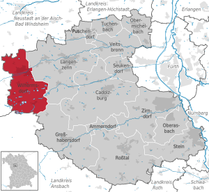
| Location of the Wilhermsdorf market in the Fürth district | ||
  |
||


Wilhermsdorf is a market in the Middle Franconian district of Fürth and belonged to the district of Neustadt an der Aisch until the municipal reform in 1972 .
geography
Geographical location
The market is located between the city of Fürth and Bad Windsheim on the edge of the Frankenhöhe Nature Park.
The Zenn flows through Wilhermsdorf and joins the Regnitz at Atzenhof . The place should not be confused with the community of Wilhelmsdorf, which is 15 km away .
Neighboring communities
The neighboring communities are:
(List: starting in the north and clockwise)
Community structure
The municipality has 14 officially named parts of the municipality (the type of settlement and the number of inhabitants as of January 2013 are given in brackets ):
|
|
The deserts Denzel- and Walkmühle are no officially designated vilage.
history
Until the 19th century


The foundation of Wilhermsdorf probably goes back to the Carolingians in the 9th century. Regil de Willehalmesdorff was first mentioned in a document from 1096. Over time, Wilhalmsdorf became Wilhelmßdorff or Wilhelmsdorf and later Wilhermsdorf. The place name has the personal name Willihalm as a defining word, which can be seen as the founder of the place.
In 1566 Wolff von Wilhelmsdorf sold the manors Wilhelmsdorf and Neidhardswinden to the brothers Schutzbar called Milchling . Heinrich Hermann von Burgmilchling, born in 1536, was the most important and later sole owner of Wilhelmsdorf. In 1569 Heinrich Hermann was elevated to the status of imperial baron by the emperor. With the death of Wolff von Wilhelmsdorf in 1569, his family died out.
The Reformation , which was implemented in the region from 1528, was only carried out in Wilhermsdorf in 1572 after the previous rule of the church patronage died out in 1569 (with Wolf von Wilhermsdorf) and the barons of Milchling took off.
Heinrich Hermann rebuilt the burned down Veste Wilhelmsdorf as a stately moated castle with the name Veste Burgmilchling. Heinrich Hermann von Burgmilchling the Elder died in 1592. In 1593 his son Heinrich Herrmann von Burgmilching the Younger took over the rule. According to tradition, he was a kind lord of the castle and a friend of science. In 1597 Emperor Rudolf II granted him the privilege of minting his own thalers. In 1612 Wilhermsdorf was raised to rule with its own blood jurisdiction and thus received the status of an imperial direct state. The imperial knighthood rule was assigned to the canton Altmühl in the Franconian knight circle . The former stately office building is located west of the main church and is now used by a brewery and as a country inn.
During the Thirty Years' War , the mercenary and military leader Mansfeld marched from Wilhermsdorf to the Hoheneck office in October 1621 . Gustav Adolf of Sweden stayed at the fortress Burgmilchling in 1632. In 1656 Heinrich Hermann von Burgmilchling the Younger died without descendants, after his death Wilhermsdorf changed hands several times. Between 1659 and 1667, the place belonged to Georg Hannibal von Egk , an exile from Austria . Around this time the place also became the new home of numerous religious expellees, primarily from Lower Austria.
In 1667, Count Wolfgang Julius von Hohenlohe-Neuenstein acquired the rule of Wilhermsdorf and Neidhardswinden. Under his rule, the traces of were the Thirty Years War eliminated and Wilhermsdorf received in 1671 by Emperor Leopold I , the market law awarded. Between 1672 and 1693 he had the fortress Burgmilchling demolished and then a residential palace with outbuildings and a palace complex was built. He gave the Jews resident in Wilhermsdorf permission to operate printing works. Jewish writings printed in Wilhermsdorf were sent all over the world, for example an edition of the Ma'assebuch published in 1673/77 . In 1689, after the death of his wife, the Duchess of Holstein, Wolfgang Julius married the young Countess Franziska Barbara von Welz , who came from an Austrian family of exiles . In 1698, Wolfgang Julius died at the age of 76 after nine years of marriage. The marriage remained childless. In 1701 the 35-year-old Franziska Barbara married Count Philipp Ernst zu Hohenlohe-Waldenburg-Schillingsfürst. Franziska Barbara stayed in Wilhermsdorf, and under her rule Wilhermsdorf experienced a heyday when she realized the building projects planned by Julius Wolfgang.

After her death in 1718, Franziska Barbara was solemnly buried in a magnificent coffin in the crypt of the main Protestant church. After the death of Philipp Ernst, the Wilhermsdorf and Neidhardswinden fiefs fell to the two underage children. In 1733 the son of Philipp Ernst took over the rule of Wilhermsdorf, he too had no descendants. His nephew, Count Philipp Ferdinand zu Limburg, Bronchorst-Styrum took over the rule. Due to his high debts, he was forced to sell this property in 1769 and sell it to the Fulda privy councilor Baron Erasmus Wurster von Kreuzberg (for the high sum of 360,000 guilders), who was married to the Nuremberg patrician daughter Dorothea Marie Kressenstein . Her son, Baron Johannes Friedrich Wurster von Kreuzberg, received an annual pension from the fief and died in Nuremberg in 1839, the last of his family. The administration of Wilhermsdorf had already been taken over by the Bavarian state (also sovereign in Ansbach).

The knightly canton of Altmühl moved its office from Rügland to Wilhermsdorf in 1703 and established its new office to the east of the church on the market square around 1720. This administration building is still called the Ritterhaus today.
At the end of the 18th century there were 130 properties in Wilhermsdorf. The high court and the village and community rulership exercised the rule Wilhermsdorf . The landlords were the lordship of Wilhermsdorf (castle, office building, hospital, rectory, schoolhouse, poor house, 3 inns, tavern, shepherd's house, 112 houses) and the knightly canton of Altmühl (3 houses).
In 1791 the neighboring margraviate of Ansbach passed to the Kingdom of Prussia . The governing minister Karl August Freiherr von Hardenberg tried to round off the area by buying up rulers, but only partially succeeded. He increased the pressure on the territories of the imperial knighthood through imperial interventions and military actions, which for the most part were contrary to imperial law. Apart from protests and lawsuits in Vienna and the notices there, including execution orders, nothing could be obtained, let alone enforce these execution orders. Almost all files in the archives and registry of the canton Altmühl were confiscated on November 22, 1796 by a government commission from Ansbach and taken to Ansbach in order to deprive the imperial knights of important documents for the conduct of the litigation. Soldiers were also deployed here. This had been preceded by Prussian patent applications in the knightly lordships and imperial cities bordering Ansbach-Bayreuth in February and March 1792.
In 1796 the place came under Prussian sovereignty, on December 15, 1805 it went to France for a short time with the Principality of Ansbach in exchange for the Electorate of Hanover and was incorporated into the Kingdom of Bavaria in 1806. At the same time, the immediate rights of the imperial knighthoods were withdrawn.
In 1806 Wilhermsdorf came to the Kingdom of Bavaria . As part of the municipal edict , the tax district Wilhermsdorf was formed in 1808 , to which Denzelmühle , Fallmeisterei , Lenzenhaus , Walkmühle belonged. In 1813 the municipality of Wilhermsdorf was formed, which was congruent with the tax district. It was subordinate to the Cadolzburg Regional Court in administration and jurisdiction and to the Cadolzburg Rent Office in the financial administration . The voluntary jurisdiction and local police, however, were held by the Wilhermsdorf patrimonial court until 1839 . On October 1, 1842, Wilhermsdorf was assigned to the Markt Erlbach regional court and the Neustadt an der Aisch rent office ( renamed Neustadt an der Aisch tax office in 1920 ). From 1862 Wilhermsdorf was administered by the Neustadt an der Aisch district office (renamed the Neustadt an der Aisch district in 1938 ). The jurisdiction remained with the district court of Markt Erlbach until 1879, from 1880 to 1959 district court of Markt Erlbach , from 1959 district court of Fürth . The community originally had an area of 5.944 km², which was then enlarged in 1958 by the incorporation of Unterulsenbach to 8.069 km².
The ruling judge Gottlieb Christian Eberhard Wunder took over the jurisdiction of Wilhermsdorf and Buchklingen in 1817 on behalf of King Ludwig.
The oldest club in Wilhermsdorf is the shooting club from 1846; it arose in a wave of associations being founded in the 19th century. In the years 1878/1879, the residential palace was demolished after the state auctioned the uninhabited and neglected building to a private person. In 1895 the Zenngrundbahn reached Wilhermsdorf.
20th century
In 1907 the place was connected to the power grid.
The Johanneszweigverein was founded in 1907 to support the children's school.
In 1930, the Wilhermsdorf – Unteraltenbernheim stagecoach connection was discontinued.
In June 1928, the teacher Adolf Meyer (1895–1966) founded a local NSDAP group in Wilhermsdorf, was its first leader and was elected to the first National Socialist councilor of Wilhermsdorf on December 8th. From May 1932 Meyer acted as second mayor until he was transferred to Neustadt an der Aisch in autumn 1933 so that his son could attend secondary school there. According to an assessment by the mayor and later district administrator Heinrich Sperber in March 1947, Meyer probably saved several Wilhermsdorf citizens from being sent to the Dachau concentration camp. During the Nazi era , Adolf Meyer was the speaker of the Fürth city councilor Franz Jakob in Wilhermsdorf at NSDAP events in 1932. The Jews were expelled and the market declared itself “free of Jews” in December 1938. In 1963 the Catholic parish built a church. In 1964 a new school building was inaugurated on the Steige. On July 1, 1972, Wilhermsdorf was reclassified from the Neustadt an der Aisch district to the Fürth district as part of the regional reform in Bavaria . As part of this regional reform, some places south of Wilhermsdorf were incorporated.
In 1976 an indoor swimming pool was built on the road to Unterulsenbach.
Jewish Cemetery

A Jewish cemetery in Wilhermsdorf has existed on the road to Siedelbach since at least the middle of the 15th century . An illustration from 1842 shows a tombstone with the year 5212 in the Jewish calendar , that would be 1452. The oldest legible tombstone dates from 1690; from that year a death register was kept, which was updated until the last burial on April 8, 1936. In 1865 the cemetery was expanded. Citizens from the neighboring communities of Markt Erlbach and Dietenhofen also lie in the 39.5 ares large cemetery. Today there are still around 500 tombstones.
Incorporations
1958 Unterulsenbach was incorporated. On January 1, 1971, the previously independent community of Dippoldsberg was incorporated. On July 1, 1972, parts of the dissolved Katterbach community were added. Kirchfarrnbach followed on January 1, 1978.
Population development
Wilhermsdorf community
| year | 1818 | 1840 | 1852 | 1861 | 1867 | 1871 | 1875 | 1880 | 1885 | 1890 | 1895 | 1900 | 1905 | 1910 | 1919 | 1925 | 1933 | 1939 | 1946 | 1950 | 1961 | 1970 | 1987 | 1995 | 2005 | 2016 |
|---|---|---|---|---|---|---|---|---|---|---|---|---|---|---|---|---|---|---|---|---|---|---|---|---|---|---|
| Residents | 1172 | 1190 | 1364 | 1348 | 1313 | 1311 | 1326 | 1351 | 1304 | 1232 | 1298 | 1398 | 1448 | 1419 | 1370 | 1507 | 1737 | 1717 | 2415 | 2605 | 3029 | 2967 | 3937 | 4535 | 5065 | 5177 |
| Houses | 368 | 185 | 218 | 201 | 203 | 248 | 303 | 468 | 993 | 1551 | ||||||||||||||||
| source |
Wilhermsdorf part of the municipality
| year | 1818 | 1840 | 1861 | 1871 | 1885 | 1900 | 1925 | 1950 | 1961 | 1970 | 1987 | 2018 |
|---|---|---|---|---|---|---|---|---|---|---|---|---|
| Residents | 1172 | 1172 | 1322 | 1289 | 1267 | 1365 | 1478 | 2563 | 2897 | 2940 | 3137 | 4318 |
| Houses | 368 | 180 | 195 | 198 | 243 | 298 | 446 | 801 | ||||
| source |
politics

Market council
The municipal council of Wilhermsdorf consisted of 16 members at the local elections in 2002; Due to the increased population, the number of mandates to be awarded was increased to 20 for the 2008 election.
| CSU | SPD | FW | Green | Non-party | total | |
| 2002 | 8th | 6th | 2 | 0 | 0 | 16 seats |
| 2008 | 9 | 7th | 3 | 0 | 1 | 20 seats |
| 2014 | 11 | 5 | 4th | 0 | 0 | 20 seats |
| 2020 | 12 | 3 | 3 | 2 | 0 | 20 seats |
mayor
Harry Scheuenstuhl (SPD) was 1st Mayor since May 1, 1996 . In 2002 he was confirmed in office with 54.6%. On March 16, 2008 he won the runoff election against Werner Koch (CSU) with 53.7% to 46.3% of the vote.
Uwe Emmert (CSU) has been 1st Mayor since March 16, 2014. He won the 2014 local election in the first round with 52.8%. Scheuenstuhl did not take part in this election.
In the subsequent local elections in 2020, Emmert was able to prevail again against his opponents Ruf (Free Voters), Kleefeld (Greens) and Kropstat (SPD).
badges and flags
|
|
Blazon : “ Divided by gold and blue; above three red diamonds standing side by side, below the silver capital letter W. "
Blue-yellow-red municipal flag |
| Foundation of the coat of arms: In 1926 the coat of arms was redesigned, using the coat of arms of the Lords of Wilhelmsdorf and adding the silver W. The W should indicate the place name, the colors blue and silver are the Bavarian state colors. The coat of arms was certified by the Bavarian Ministry of the Interior by a ministerial resolution of June 23, 1926. |
Town twinning
-
 Austria : Feld am See , since 1988
 -
 Germany : Jahnsdorf / Erzgebirge in Saxony , since 1998
Culture and sights
town hall
The town hall is a stately residential and administrative building built under Franziska-Barbara between 1717 and 1718. This Consulentenhaus was extended between 1719 and 1720 by a wing at the rear, on the upper floor of which there is a baroque ballroom . It was privatized by the Kingdom of Bavaria in 1811 and used as a craftsman's house. In 1939 the market bought the house to use it as a town hall. Between 2000 and 2005 the house was renovated and expanded.
Architectural monuments
Sports
TSV 1886 Wilhermsdorf e. V. consists of the football, judo, tennis, table tennis, gymnastics and volleyball departments.
The association Badfreunde-Wilhermsdorf eV has existed since December 2017 to maintain and renovate the indoor and outdoor pools.
Regular events
Parish fair is held every year at Whitsun and in mid-September. The market square festival takes place in mid-July.
Economy and Infrastructure
traffic
The national road 2252 goes from East to West by the municipality and binds the place to Langenzenn to the Südwesttangente ( State Road 8 ) at or leads to Emskirchen . The district road NEA 23 / FÜ 18 leads to Siedelbach or Meiersberg . Municipal roads lead to Dürrnbuch to NEA 19 and to Dippoldsberg .
In 2002, the connection between Ansbacher Strasse and Nürnberger Strasse south of the railway line created a bypass road that relieved the center of a large part of the through traffic.
Since September 9, 1895, the Zenngrundbahn has been connecting the town with the Siegelsdorf station on the Nuremberg – Würzburg railway line ; on December 5, 1902, it was extended to Markt Erlbach; the trains run partly to and from Fürth Hbf, partly to and from Nürnberg Hbf. In 1998 the Wilhermsdorf Mitte station also went into operation.
energy
Since 2009, the highest wind turbines in Bavaria have been located in Wilhermsdorf in the form of two Enercon E-82 wind turbines with a hub height of 138 meters and a total height of 179 meters. Since 2010 there have been three more wind turbines of the same type on the market area. Each system can produce 2.3 MW.
Personalities
Sons and daughters of the church
- August Luchs (1849–1938), German classical philologist
- Philipp Ferdinand von Limburg-Styrum (1734–1794), German nobleman, heir of Wilhermsdorf and the rule of Oberstein an der Nahe
Personalities who have worked on site
- Salomon Schweigger (1551–1622), Protestant preacher and traveler to the Orient
- Count Wolfgang Julius von Hohenlohe-Neuenstein (1622–1698), German field marshal and last count of Hohenlohe-Neuenstein
- Countess Franziska Barbara zu Welz-Wilmersdorf (1666–1718), wife of Count Wolfgang Julius von Hohenlohe-Neuenstein, mistress of Wilhermsdorf
- Adam Ernst Reichard (1670–1756), German Baroque organ builder
- Johann Gerhard Pagendarm (1681–1754), court and town chaplain from 1713 to 1719
- Johann Christoph Wiegleb (1690–1749), German Baroque organ builder
- Gottlieb Christian Eberhard Wunder (March 4, 1787 - November 25, 1864), judge in Wilhermsdorf
- Gotthilf Fischer (* 1928) founded the Association for the Preservation of German Songs , which is based in Wilhermsdorf.
literature
- Johann Kaspar Bundschuh : Wilhermsdorf . In: Geographical Statistical-Topographical Lexicon of Franconia . tape 6 : V-Z . Verlag der Stettinische Buchhandlung, Ulm 1804, DNB 790364328 , OCLC 833753116 , Sp. 242 ( digitized version ).
- Armin Dürr: From the ministerial headquarters to the market town. Wilhermsdorf from 1096 to 1996. Wilhermsdorf 1995
- Hanns Hubert Hofmann : Neustadt-Windsheim (= Historical Atlas of Bavaria, part of Franconia . I, 2). Commission for Bavarian State History, Munich 1953, DNB 452071216 , p. 141 ( digitized version ). Ibid. S. 207 ( digitized version ).
- Georg Muck: History of Heilsbronn Monastery from prehistoric times to modern times . tape 2 . For Kunstreprod. Schmidt, Neustadt an der Aisch 1993, ISBN 3-923006-90-X , p. 372–374 (first edition: Beck, Nördlingen 1879).
- Wolf-Armin von Reitzenstein : Lexicon of Franconian place names. Origin and meaning . Upper Franconia, Middle Franconia, Lower Franconia. CH Beck, Munich 2009, ISBN 978-3-406-59131-0 , p. 244 .
- Hans Sponholz et al. (Ed.): District Neustadt an der Aisch . Verl. F. Authorities and Economy Hoeppner, Aßling-Pörsdorf / Obb. 1972, DNB 720137675 , p. 134-138 .
- Richard Strobel: District Neustadt an der Aisch (= Bavarian art monuments . Volume 32 ). Deutscher Kunstverlag, Munich 1972, DNB 730125742 , p. 188-200 .
- Pleikard Joseph Stumpf : Wilhermsdorf . In: Bavaria: a geographical-statistical-historical handbook of the kingdom; for the Bavarian people . Second part. Munich 1853, p. 714 ( digitized version ).
- Johann Christian Wibel: Historical description of Wilhermsdorff, including the names of the place, location, construction, removal and acceptance, owners and other circumstances, as well as sufficient information is given in an appendix from the two knightly estates of Neuses and Buchklingen. ("Printed with Lochner scriptures") Nuremberg 1742 (incomplete and not always reliable)
Web links
- Wilhermsdorf: Official statistics of the LfStat
- Wilhermsdorf in the Topographia Franconiae of the University of Würzburg , accessed on September 21, 2019.
- Map of Wilhermsdorf 1827
Individual evidence
- ↑ "Data 2" sheet, Statistical Report A1200C 202041 Population of the municipalities, districts and administrative districts 1st quarter 2020 (population based on the 2011 census) ( help ).
- ^ Community Wilhermsdorf in the local database of the Bavarian State Library Online . Bavarian State Library, accessed on September 21, 2019.
- ^ Max Döllner : History of the development of the city of Neustadt an der Aisch until 1933. Ph. CW Schmidt, Neustadt ad Aisch 1950, pp. 73 f.
- ↑ W.-A. v. Reitzenstein, p. 244.
- ↑ Max Döllner (1950), pp. 190 and 195.
- ^ Max Döllner : History of the development of the city of Neustadt an der Aisch up to 1933. Ph. C. W. Schmidt, Neustadt a. d. Aisch 1950, OCLC 42823280 ; New edition to mark the 150th anniversary of the Ph. C. W. Schmidt publishing house, Neustadt an der Aisch 1828–1978. Ibid 1978, ISBN 3-87707-013-2 , p. 231.
- ^ Werner Wilhelm Schnabel: Georg Hannibal von Egk. Owner of Wilhermsdorf from 1659 to 1667. In: Wilmersdorfer Heimatblättla 19 (1994), pp. 1-7.
- ↑ Eberhard Krauss: Exulanten in the earlier Evang.-Luth. Deanery Markt Erlbach in the 17th century (sources and research on Franconian family history, 26) . Society for Family Research in Franconia, Nuremberg 2011, ISBN 978-3-929865-35-6 , p. 51-59 and passim .
- ↑ Max Döllner (1950), p. 137.
- ^ Office in Rügland
- ↑ http://gestern.nordbayern.de/bild.asp?bild=462948&ar=0&man=2&kat=12 (link not available)
- ↑ HH Hofmann, p. 141.
- ↑ Michael Puchta Mediatization "with skin and hair, body and life": The submission of the Imperial Knights by Ansbach-Bayreuth (1792–1798) Verlag Vandenhoeck & Ruprecht, 2012; 813 pages ISBN 978-3-525-36078-1
- ^ HH Hofmann, p. 226. Address and statistical handbook for the Rezatkreis in the Kingdom of Baiern . Buchdruckerei Chancellery, Ansbach 1820, p. 28 ( digitized version ).
- ↑ HH Hofmann, p. 207.
- ↑ a b c Bavarian State Statistical Office (Hrsg.): Official local directory for Bavaria - edited on the basis of the census of September 13, 1950 . Issue 169 of the articles on Bavaria's statistics. Munich 1952, DNB 453660975 , Section II, Sp. 1102-1104 ( digitized version ).
- ↑ a b c Bavarian State Statistical Office (ed.): Official city directory for Bavaria, territorial status on October 1, 1964 with statistical information from the 1961 census . Issue 260 of the articles on Bavaria's statistics. Munich 1964, DNB 453660959 , Section II, Sp. 808 ( digitized version ).
- ^ Wolfgang Mück: Nazi stronghold in Middle Franconia: The völkisch awakening in Neustadt an der Aisch 1922–1933. Verlag Philipp Schmidt, 2016 (= Streiflichter from home history. Special volume 4); ISBN 978-3-87707-990-4 , pp. 222-225.
- ↑ Wolfgang Mück (2016), p. 224, note 680.
- ↑ Wolfgang Mück (2016), p. 144.
- ↑ Wolfgang Mück (2016), p. 114.
- ↑ " Der Stürmer ", issue no. 51, December 1938
- ^ Armin Dürr: From the ministerial headquarters to the market community. Wilhermsdorf from 1096 to 1996. Wilhermsdorf 1995
- ^ Wilhelm Volkert (ed.): Handbook of Bavarian offices, communities and courts 1799–1980 . CH Beck, Munich 1983, ISBN 3-406-09669-7 , p. 536 .
- ^ Federal Statistical Office (ed.): Historical municipality directory for the Federal Republic of Germany. Name, border and key number changes in municipalities, counties and administrative districts from May 27, 1970 to December 31, 1982 . W. Kohlhammer, Stuttgart / Mainz 1983, ISBN 3-17-003263-1 , p. 714 .
- ↑ a b Only inhabited houses are given. In 1818 these were designated as fireplaces , in 1840 as houses , and from 1871 to 2016 as residential buildings.
- ↑ a b Alphabetical index of all the localities contained in the Rezatkreise according to its constitution by the newest organization: with indication of a. the tax districts, b. Judicial Districts, c. Rent offices in which they are located, then several other statistical notes . Ansbach 1818, p. 103 ( digitized version ).
- ^ A b Eduard Vetter (Ed.): Statistical handbook and address book of Middle Franconia in the Kingdom of Bavaria . Self-published, Ansbach 1846, p. 102-103 ( digitized version ). According to the historical municipality register , the municipality had 1,172 inhabitants.
- ↑ a b c d e f g h i j k l Bavarian State Statistical Office (Hrsg.): Historical municipality directory: The population of the municipalities of Bavaria from 1840 to 1952 (= contributions to Statistics Bavaria . Issue 192). Munich 1954, DNB 451478568 , p. 180 , urn : nbn: de: bvb: 12-bsb00066439-3 ( digitized version ).
- ↑ a b Joseph Heyberger, Chr. Schmitt, v. Wachter: Topographical-statistical manual of the Kingdom of Bavaria with an alphabetical local dictionary . In: K. Bayer. Statistical Bureau (Ed.): Bavaria. Regional and folklore of the Kingdom of Bavaria . tape 5 . Literary and artistic establishment of the JG Cotta'schen Buchhandlung, Munich 1867, Sp. 1062 , urn : nbn: de: bvb: 12-bsb10374496-4 ( digitized version ).
- ↑ a b Kgl. Statistical Bureau (ed.): Complete list of localities of the Kingdom of Bavaria. According to districts, administrative districts, court districts and municipalities, including parish, school and post office affiliation ... with an alphabetical general register containing the population according to the results of the census of December 1, 1875 . Adolf Ackermann, Munich 1877, 2nd section (population figures from 1871, cattle figures from 1873), Sp. 1229–1230 , urn : nbn: de: bvb: 12-bsb00052489-4 ( digitized version ).
- ↑ a b K. Bayer. Statistical Bureau (Ed.): Localities directory of the Kingdom of Bavaria. According to government districts, administrative districts, ... then with an alphabetical register of locations, including the property and the responsible administrative district for each location. LIV. Issue of the contributions to the statistics of the Kingdom of Bavaria. Munich 1888, Section III, Sp. 1163–1164 ( digitized version ).
- ↑ a b K. Bayer. Statistical Bureau (Ed.): Directory of localities of the Kingdom of Bavaria, with alphabetical register of places . LXV. Issue of the contributions to the statistics of the Kingdom of Bavaria. Munich 1904, Section II, Sp. 1236 ( digitized version ).
- ↑ a b Bavarian State Statistical Office (ed.): Localities directory for the Free State of Bavaria according to the census of June 16, 1925 and the territorial status of January 1, 1928 . Issue 109 of the articles on Bavaria's statistics. Munich 1928, Section II, Sp. 1274 ( digitized version ).
- ↑ a b Bavarian State Statistical Office (Hrsg.): Official local directory for Bavaria . Issue 335 of the articles on Bavaria's statistics. Munich 1973, DNB 740801384 , p. 174 ( digitized version ).
- ↑ a b Bavarian State Office for Statistics and Data Processing (Ed.): Official local directory for Bavaria, territorial status: May 25, 1987 . Issue 450 of the articles on Bavaria's statistics. Munich November 1991, DNB 94240937X , p. 337 ( digitized version ).
- ^ Wilhermsdorf: Official statistics of the LfStat
- ↑ www.markt-wilhermsdorf.de
- ^ Markt Wilhermsdorf: Facts and Figures , accessed on December 11, 2012
- ↑ Election of the first mayor - 2020 municipal elections in the Wilhermsdorf market - overall result. Retrieved March 30, 2020 .
- ^ Entry on the coat of arms of Wilhermsdorf in the database of the House of Bavarian History
- ^ Wilhermsdorf. In: Kommunalflaggen.eu. Retrieved June 24, 2020 .
- ↑ Bath Friends-Wilhermsdorf: Statute (PDF online) .
- ↑ http://www.landkreis-fuerth.de/uploads/media/Umweltinformation_14.pdf (link not available)
- ↑ “I get the greatest applause with old songs” .

Ammerndorf | Cadolzburg | Großhabersdorf | Langenzenn | Oberasbach | Obermichelbach | Puschendorf | Ross Valley | Seukendorf | Stone | Tuchenbach | Veitsbronn | Wilhermsdorf | Zirndorf