
Fürth district
| coat of arms | Germany map |
|---|---|

|

Coordinates: 49 ° 27 ' N , 10 ° 51' E |
| Basic data | |
| State : | Bavaria |
| Administrative region : | Middle Franconia |
| Administrative headquarters : | Zirndorf |
| Area : | 307.55 km 2 |
| Residents: | 117,853 (Dec. 31, 2019) |
| Population density : | 383 inhabitants per km 2 |
| License plate : | FÜ |
| Circle key : | 09 5 73 |
| NUTS : | DE258 |
| Circle structure: | 14 municipalities |
| Address of the district administration: |
Im Pinderpark 2 90513 Zirndorf |
| Website : | |
| District Administrator : | Matthias Dießl ( CSU ) |
| Location of the Fürth district in Bavaria | |
 .svg) |
|

The district of Fürth is a district west of the cities of Fürth and Nuremberg in the Bavarian administrative district of Middle Franconia . The district is a member of the Nuremberg Metropolitan Region .
geography
location
The district of Fürth includes the cities of Zirndorf , Stein and Oberasbach , but not the eponymous city of Fürth itself, which is independent . Towards the west, the district merges into the agricultural region of western Central Franconia . In terms of area, the Fürth district is the smallest district in Bavaria. The landscape is shaped by the south-west German plains: the plateau of the sandstone keupers is cut through by the Bibert , the Zenn and smaller rivers in wide valleys. Due to the abundant teaching mountain layers (clays) there is a rich brick industry in the northern district, especially in Langenzenn .
Neighboring areas
The district borders clockwise to the north, beginning with the district of Erlangen-Höchstadt , the independent cities of Erlangen , Fürth and Nuremberg, and the districts of Roth , Ansbach and Neustadt an der Aisch-Bad Windsheim .
history
Until 1862
Before 1800, the area of today's Fürth district belonged to different rulers, including the Burgraviate of Nuremberg and the Principality of Ansbach . In 1806 the area came to Bavaria. In 1808 the Cadolzburg district court was established, which initially belonged to the Pegnitz district and from 1810 to the Rezat district . As early as 1809, Fürth became a city in the immediate vicinity of a district.
District Office
In the spring of 1862, the new district court of the older order Fürth was formed from a total of 18 communities from the district courts of Cadolzburg, Erlangen and Nuremberg. In the same year, this merged with the Cadolzburg district court to form the Fürth district office . Although the city of Fürth became the administrative seat of the new district, it remained independent.
On January 1, 1900, the Fürth district office handed over the Poppenreuth community to the city of Fürth. On January 1, 1901, Dambach also came to Fürth. Unterfarrnbach followed on January 1, 1918.
On November 1, 1923, Schnepfenreuth was incorporated into Nuremberg. Burgfarrnbach came to Fürth on December 3, 1923, and Buch to Nuremberg on May 1, 1924 .
Ronhof was given to the city of Fürth on July 1, 1927, Höfles on April 1, 1928 and Kraftshof to the city of Nuremberg on January 1, 1930.
On October 1, 1931, the community of Puschendorf of the district office of Höchstadt an der Aisch came to the district office of Fürth.
district
On January 1, 1939, the designation district was introduced as everywhere else in the German Reich . So the district office became the district of Fürth.
On January 1, 1972, the Kirchfembach community in the Neustadt an der Aisch district was reorganized into the Fürth district and incorporated into the town of Langenzenn .
The district was badly affected by the territorial reform that came into force on July 1, 1972. The communities Boxdorf , Großgründlach and Neunhof came to the independent city of Nuremberg, while the communities Sack , Stadeln and Vach came to the independent city of Fürth. Since the district became the smallest district in terms of area in Bavaria, a division of the remaining area into the neighboring districts of Ansbach and Neustadt an der Aisch as well as the city of Nuremberg was under discussion, but the planning was discarded. To compensate for the loss of the agricultural and economically strong communities in the north, the district of Fürth received the town of Stein from the then district of Nuremberg and the communities of Katterbach and Wilhermsdorf from the district of Neustadt an der Aisch.
In spring 2003, the district seat of the Fürth district was relocated to Zirndorf after a new district office had been built there. Since then, the district administration has been located within the district area.
Population development
From 1988 to 2008 the district of Fürth grew by around 18,600 inhabitants or around 19%. Growth has slowed in recent years.
The following figures refer to the territorial status on May 25, 1987.
| Population development | ||||||||||||||
|---|---|---|---|---|---|---|---|---|---|---|---|---|---|---|
| year | 1840 | 1900 | 1939 | 1950 | 1961 | 1970 | 1987 | 1991 | 1995 | 2000 | 2005 | 2010 | 2015 | |
| Residents | 19,025 | 24,701 | 36,705 | 54,850 | 62.105 | 75,261 | 93,861 | 100,562 | 110.176 | 112,896 | 114.024 | 114,810 | 114.291 | |
politics
(March 2014: 53.4%)
District Administrator
- 1945–1958: Friedrich Hörndlein, initially provisional district administrator
- 1958–1972: Heinrich Löffler, SPD
- 1972–1990: Dietrich Sommerschuh , SPD
- 1990–2008: Gabriele Pauli , from November 21, 2007 non-party, before that CSU
- since 2008: Matthias Dießl , CSU
District council
| CSU | GREEN | SPD | FW | AfD | FDP | Others | total | |
| Local election 1996 | 27 | 5 | 21st | 4th | 3 | 60 seats | ||
| Local election 2002 | 28 | 4th | 21st | 4th | 3 | 60 seats | ||
| Local election 2008 | 26th | 5 | 19th | 7th | 3 | 60 seats | ||
| Local election March 2014 [election invalid] | 26th | 7th | 17th | 8th | 2 | 60 seats | ||
| New election November 2014 | 25th | 7th | 17th | 9 | 2 | 60 seats | ||
| Local election 2020 | 23 | 11 | 10 | 7th | 4th | 2 | 3 | 60 seats |
The election for the district council of March 16, 2014 was subsequently declared invalid by the government of Central Franconia on July 24, 2014 because two mayors had suggested in the respective official gazette that applicants from their own town should be given preference. The election was repeated on November 16, 2014, when the turnout fell from 53% to 29%.
coat of arms
|
|
Blazon : “Above a shortened red tip, inside a vertically standing golden ear, on top of which an above silver cogwheel growing from the lower edge of the shield, split; in front in silver half a red eagle with gold armor at the slit, with a golden clover stem on the wing, in the back divided diagonally five times by red and silver. " |
| Foundation of the coat of arms: The red eagle was the symbol of the principality of Ansbach, red and silver the colors of the burgraviate of Nuremberg, ears of wheat and cogwheel stand for agriculture and industry. |
logo
The old logo, a circle with a color gradient from white to green, touched by three blue stripes, was replaced by a modernized version in 2009 after about 15 years of validity. The new logo adopts the dominant heraldic colors of silver, black and red in the district coat of arms . The circle became a three-dimensional ring made of silver with black shading, which is touched by three red stripes. In contrast to the old logo, these are no longer the same length and are intended to symbolize the cities of Nuremberg, Fürth and Erlangen on the one hand, and to represent an F on the other . A new claim has been added: “ Capable of performing. Life is happy ”, in which the district's initials L and F can be found.
District partnerships
In 1972 the sponsorship for the expelled Sudeten Germans from the city of Haida, the city and the district of Bohemian Leipa and the city and the district of Dauba was taken over.
Economy and Infrastructure

The district is more agricultural. Well-known companies based in the district are the Playmobil manufacturer Geobra Brandstätter and the Metz-Werke in Zirndorf, Faber-Castell in Stein and the Cadolto company from Cadolzburg. Brick factories can still be found in Langenzenn today . The first Playmobil FunPark opened in the Zirndorf district of Leichendorf in 2000 .
Road traffic
There is no motorway in the area of the district. The district is traversed in the north by the B 8 (Nuremberg - Würzburg), with the B 8 between the city limits of Fürth and beyond Langenzenn being developed like a motorway. The so-called Südwesttangente was originally planned as the A 752. In the south of the district, the B 14 (Pilsen - Nuremberg - Stuttgart) runs from Stein to Buchschwabach .
License Plate
On July 1, 1956, the district was assigned the distinctive sign FÜ when the vehicle registration number that is still valid today was introduced . It is still issued today.
Local public transport
In 1844, a railway operated for the first time with the construction of the Ludwig-Süd-Nord-Bahn in the Fürth district. From here the route to Würzburg branched off in Fürth in 1865 . The Nuremberg – Crailsheim railway has been running through the south of the district since 1875 . The surrounding area was later developed by three local railways:
The Bavarian State Railways ran the Zenngrundbahn from Siegelsdorf to Langenzenn in 1872 , to Wilhermsdorf in 1895 and finally to Markt Erlbach in 1902. This was followed by the local railway company Munich in 1890/92 with the Rangaubahn (popularly Moggerla) from Fürth via Zirndorf to Cadolzburg.
Finally, in 1914, another local railway of the Bavarian State Railways was added, the Bibertbahn (in common parlance Bibert-Bärbel), which separated from the Ansbacher Hauptbahn in Nürnberg-Stein and ran via Fürth Süd and Zirndorf-Altenberg in the direction of Unterstbibert-Rügland. Passenger traffic on this line was completely shut down in 1971 from Großhabersdorf and in 1986. This has reduced the railway network by almost a quarter from 87 km to 69 km.
Since then, the Bibert Valley has been served by a bus line operated by Omnibusverkehr Franken (OVF). The future of the track between Leichendorf and Stein is uncertain. Various plans in the 1990s provided for a connection between the stump and the Rangau Railway. The plans failed due to economic viability, the subway construction plans in Nuremberg and political resistance in the district. Instead of or until the Nuremberg U3 underground line continues into the district, operations on the route are to be resumed. The Bibertbahn interest group is committed to this.
The rest of the district is served by bus lines and at night and on weekends by a shared call taxi . In addition, the night buses called Night-Liner run every hour between the Fürth town hall or Nuremberg main station and individual district communities on Saturdays, Sundays, public holidays and bridging days . Since the start of the Verkehrsverbund Großraum Nürnberg (VGN), you only need a ticket to use local public transport.
Various plans exist or have existed to extend the Nuremberg U-Bahn (e.g. line U2 to Stein bei Nürnberg or line U3 to Oberasbach ) or the Erlangen city-surrounding railway into the district, but there are none as of 2018 concrete plans known.
Communities
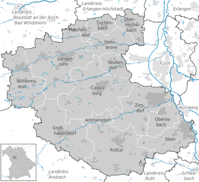
The district of Fürth is made up of 14 municipalities, four of which are cities (residents on December 31, 2019).
|
Other communities
|
|
Municipalities of the district before the territorial reform 1971/78
Before the regional reform , the district of Fürth had 34 communities, of which today three belong to the city of Fürth and three to the city of Nuremberg. In the list below, all the churches that still exist today are in bold :
| former parish | today's parish | today's district |
|---|---|---|
| Ammerndorf | Ammerndorf | Fürth district |
| Boxing village | Nuremberg | independent city of Nuremberg |
| Bronnamberg | Zirndorf | Fürth district |
| Buchschwabach | Ross Valley | Fürth district |
| Cadolzburg | Cadolzburg | Fürth district |
| Deberndorf | Cadolzburg | Fürth district |
| Fernabunst | Großhabersdorf | Fürth district |
| Großgründlach | Nuremberg | independent city of Nuremberg |
| Großhabersdorf | Großhabersdorf | Fürth district |
| Großweismannsdorf | Ross Valley | Fürth district |
| Gutzberg | stone | Fürth district |
| Horbach | Langenzenn | Fürth district |
| Germ cell | Langenzenn | Fürth district |
| Kirchfarrnbach | Wilhermsdorf | Fürth district |
| Langenzenn | Langenzenn | Fürth district |
| Foliage village | Langenzenn | Fürth district |
| Corpse Village | Zirndorf | Fürth district |
| Neunhof | Nuremberg | independent city of Nuremberg |
| Oberasbach | Oberasbach | Fürth district |
| Obermichelbach | Obermichelbach | Fürth district |
| Puschendorf | Puschendorf | Fürth district |
| Rossendorf | Cadolzburg | Fürth district |
| Ross Valley | Ross Valley | Fürth district |
| bag | Fuerth | independent city of Fürth |
| Seukendorf | Seukendorf | Fürth district |
| Barns | Fuerth | independent city of Fürth |
| Steinbach | Cadolzburg | Fürth district |
| Tuchenbach | Tuchenbach | Fürth district |
| Unterschlauersbach | Großhabersdorf | Fürth district |
| Vach | Fuerth | independent city of Fürth |
| Veitsbronn | Veitsbronn | Fürth district |
| Vine ornaments | Zirndorf | Fürth district |
| Weitersdorf | Ross Valley | Fürth district |
| Zirndorf | Zirndorf | Fürth district |
Culture and sights
Museums
Stone crosses
There are numerous stone crosses in the district , most of which are also listed as architectural monuments .
Protected areas
In the district of Fürth and the city of Fürth there are two nature reserves , four landscape protection areas , five FFH areas and three designated geotopes . (As of March 2016)
See also:
- List of nature reserves in the Fürth district
- List of landscape protection areas in the Fürth district
- List of FFH areas in the Fürth district
- List of geotopes in the Fürth district
literature
- August Gebeßler : City and District of Fürth (= Bavarian Art Monuments . Volume 18 ). Deutscher Kunstverlag, Munich 1963, DNB 451450957 .
- Hanns Hubert Hofmann : Nuremberg-Fürth (= Historical Atlas of Bavaria, part Franconia I, 4). Commission for Bavarian State History, Munich 1954, DNB 452071224 ( digitized version ).
- Wolfgang Wiessner: City and District of Fürth (= Historical Place Name Book of Bavaria, Middle Franconia . Volume 1 ). Commission for Bavarian State History, Munich 1963, DNB 455524629 .
Web links
- Official website of the Fürth district
- Literature from and about the district of Fürth in the catalog of the German National Library
- Entry on the coat of arms of the Fürth district in the database of the House of Bavarian History
Individual evidence
- ↑ "Data 2" sheet, Statistical Report A1200C 202041 Population of the municipalities, districts and administrative districts 1st quarter 2020 (population based on the 2011 census) ( help ).
- ^ Wilhelm Volkert (ed.): Handbook of Bavarian offices, communities and courts 1799–1980 . CH Beck, Munich 1983, ISBN 3-406-09669-7 , p. 467 .
- ^ Wilhelm Volkert (ed.): Handbook of Bavarian offices, communities and courts 1799–1980 . CH Beck, Munich 1983, ISBN 3-406-09669-7 , p. 97 .
- ^ Ordinance on the reorganization of Bavaria into rural districts and independent cities of December 27, 1971
- ↑ Local elections in Bavaria on March 16, 2014. Bavarian State Office for Statistics, March 19, 2014, accessed on March 21, 2014 .
- ↑ Preliminary results for the 2014 district council election on November 16, 2014 / Fürth district. (No longer available online.) Fürth district, November 20, 2014, archived from the original on December 5, 2014 ; Retrieved November 30, 2014 .
- ^ Result of the district council election 1996.
- ↑ as PWG (non-party voter community)
- ↑ as FDP / FW
- ^ Result of the district council election 2002.
- ↑ Result of the district election 2008.
- ↑ Result County Council Election 2014 on 16.03.2014.
- ↑ Result County Council Election 2014 on 16.11.2014.
- ^ Announcement of the results of the district council. March 15, 2020 .
- ↑ Press release of the government of Middle Franconia ( memento of October 19, 2014 in the Internet Archive ) of July 24, 2014
- ^ By-election of the district council of the Fürth district on November 16, 2014 ( Memento from November 1, 2014 in the Internet Archive ), press release from September 10, 2014
- ^ Entry on the coat of arms of the Fürth district in the database of the House of Bavarian History , accessed on September 5, 2017 .
- ↑ Started the new year with a new look: The Fürth district has a new logo. (PDF) (No longer available online.) In: Landkreis-Magazin. Fürth district office, January 22, 2009, p. 3 , archived from the original on July 19, 2011 ; Retrieved January 8, 2010 .
- ↑ "Data 2" sheet, Statistical Report A1200C 202041 Population of the municipalities, districts and administrative districts 1st quarter 2020 (population based on the 2011 census) ( help ).
- ^ Michael Rademacher: German administrative history from the unification of the empire in 1871 to reunification in 1990. City and district of Fürth. (Online material for the dissertation, Osnabrück 2006).

Independent cities: Amberg | Ansbach | Bamberg | Bayreuth | Coburg | Erlangen | Fürth | Yard | Nuremberg | Schwabach | Willows in the Upper Palatinate
Districts: District of Amberg-Sulzbach | District of Ansbach | Bamberg district | Bayreuth district | District of Coburg | District of Erlangen-Höchstadt | Forchheim district | Fürth district | District of Haßberge | District of Kitzingen | District of Kronach | District of Kulmbach | District of Lichtenfels | District of Neumarkt idOPf. | District Neustadt adAisch-Bad Windsheim | District Neustadt ad Waldnaab | District of Nürnberger Land | District of Roth | District of Sonneberg | District of Tirschenreuth | Weißenburg-Gunzenhausen district | District of Wunsiedel in the Fichtel Mountains
Districts:
Aichach-Friedberg |
Altötting |
Amberg-Sulzbach |
Ansbach |
Aschaffenburg |
Augsburg |
Bad Kissingen |
Bad Toelz-Wolfratshausen |
Bamberg |
Bayreuth |
Berchtesgadener Land |
Cham |
Coburg |
Dachau |
Deggendorf |
Dillingen on the Danube |
Dingolfing-Landau |
Danube Ries |
Ebersberg |
Eichstätt |
Erding |
Erlangen-Höchstadt |
Forchheim |
Freising |
Freyung-Grafenau |
Fürstenfeldbruck |
Fürth |
Garmisch-Partenkirchen |
Gunzburg |
Hatred Mountains |
Yard |
Kelheim |
Kitzingen |
Kronach |
Kulmbach |
Landsberg am Lech |
Landshut |
Lichtenfels |
Lindau (Lake Constance) |
Main-Spessart |
Miesbach |
Miltenberg |
Mühldorf am Inn |
Munich |
Neuburg-Schrobenhausen |
Neumarkt in the Upper Palatinate |
Neustadt an der Aisch-Bad Windsheim |
Neustadt an der Waldnaab |
Neu-Ulm |
Nuremberg Country |
Oberallgäu |
Ostallgäu |
Passau |
Pfaffenhofen an der Ilm |
Rain |
Regensburg |
Rhön-Grabfeld |
Rosenheim |
Roth |
Rottal-Inn |
Schwandorf |
Schweinfurt |
Starnberg |
Straubing Arch |
Tirschenreuth |
Traunstein |
Unterallgäu |
Weilheim-Schongau |
Weißenburg-Gunzenhausen |
Wunsiedel in the Fichtel Mountains |
Wurzburg
Independent cities:
Amberg |
Ansbach |
Aschaffenburg |
Augsburg |
Bamberg |
Bayreuth |
Coburg |
Erlangen |
Fürth |
Hof (Saale) |
Ingolstadt |
Kaufbeuren |
Kempten (Allgäu) |
Landshut |
Memmingen |
Munich |
Nuremberg |
Passau |
Regensburg |
Rosenheim |
Schwabach |
Schweinfurt |
Straubing |
Willows in the Upper Palatinate |
Wurzburg