
Aschaffenburg district
| coat of arms | Germany map |
|---|---|

|

Coordinates: 50 ° 1 ' N , 9 ° 14' E |
| Basic data | |
| State : | Bavaria |
| Administrative region : | Lower Franconia |
| Administrative headquarters : | Aschaffenburg |
| Area : | 699.15 km 2 |
| Residents: | 174,200 (Dec. 31, 2019) |
| Population density : | 249 inhabitants per km 2 |
| License plate : | AB , ALZ |
| Circle key : | 09 6 71 |
| NUTS : | DE264 |
| Circle structure: | 32 municipalities |
| Address of the district administration: |
Bayernstrasse 18 63739 Aschaffenburg |
| Website : | |
| District Administrator : | Alexander Legler ( CSU ) |
| Location of the district of Aschaffenburg in Bavaria | |
 .svg) |
|
The district of Aschaffenburg ( ) is located in the extreme north-west of the Bavarian administrative district of Lower Franconia . It is the most populous district in Lower Franconia and, after Ansbach, the most populous in Franconia .
geography
location
The district includes the Main lowlands in the west, the Kahlgrund in the north and extends to the heights of the Spessart in the east . In the Rohrbrunn Forest , the district has a share in the Geiersberg ( 586 m above sea level ), the highest peak in the Spessart. Over 200 km² of the district area are community-free forest areas. The Main forms part of the border with Hesse. Two communities in the southwest are to the left and west of the Main, Stockstadt and Großostheim. Here the district has a small part of the northeastern edge of the Odenwald . In the Wenigumstadt district , the Odenwald reaches a height of 280 meters. At the confluence of the Kahl with the Main, the lowest point in the district and the entire Free State lies at an altitude of about 102 meters. To the south of this is the westernmost point of Bavaria in the Karlstein district of Großwelzheim .
Neighboring areas
The district borders clockwise in the west, beginning with the districts of Darmstadt-Dieburg , Offenbach and Main-Kinzig-Kreis (all in Hesse ), the districts of Main-Spessart and Miltenberg and the independent city of Aschaffenburg (all in Bavaria).
history
Lordship and regional courts
Before 1800, the area of today's district of Aschaffenburg belonged predominantly to the ore monastery of Mainz , only in 1814 or 1816 it came to Bavaria. By order of 1 October 1814 were district courts second-class Aschaffenburg , Kaltenberg and Roth book and the rule of court first class of the Counts of Schönborn to Krombach built. In 1815 Aschaffenburg became a city in the immediate vicinity of a district . With an order of November 1, 1816, the Alzenau Regional Court was established after this former Hessian office had come to Bavaria. After the resolutions of June 30, 1828 and January 8 and 14, 1829, the Kaltenberg Regional Court was dissolved and its territory was divided between the Aschaffenburg and Alzenau Regional Courts and the Krombach Regional Court . All judicial districts belonged to the Untermainkreis and from 1838 to the administrative district of Lower Franconia and Aschaffenburg . On June 4, 1848, the Krombach Lordship Court was repealed. In 1858 the district court Schöllkrippen was established.
District Offices

The district office of Aschaffenburg was formed in 1862 through the merger of the district courts of the older order of Aschaffenburg and Rothenbuch. The district courts of Alzenau and Schöllkrippen were also combined to form the Alzenau district office .
On the occasion of the reform of the layout of the Bavarian district offices, the district office of Aschaffenburg ceded the communities Habichsthal , Krommenthal , Neuhütten , Rothenbuch and Wiesthal to the district office of Lohr am Main on January 1, 1880 .
In 1901 the city of Aschaffenburg was enlarged at the expense of the district office: on March 1st by the municipality of Leider and on July 1st by the municipality of Damm .
Counties
On January 1, 1939, as everywhere in the German Reich, the designation district was introduced. The districts of Alzenau i.UFr. and Aschaffenburg.
Aschaffenburg district
On April 1, 1939, the district ceded the community of Schweinheim to the independent city of Aschaffenburg.
As part of the regional reform in Bavaria , on July 1, 1972, the two districts of Aschaffenburg and Alzenau in Lower Franconia as well as the municipality of Rothenbuch from the former district of Lohr am Main and the communities of Pflaumheim and Wenigumstadt from the also dissolved district of Obernburg were combined to form the new district of Aschaffenburg. Aschaffenburg remained an independent city and became the seat of the new district.
On April 1, 1975, the district ceded the Gailbach community to the independent city of Aschaffenburg, and Obernau followed on May 1, 1978 .
On July 1, 1976, the Main-Spessart district ceded the municipality of Wiesen to the Aschaffenburg district.
Population development
From 1988 to 2008 the district of Aschaffenburg grew by almost 19,000 inhabitants or around 12%. Since 2005 the trend towards a high of approx. 175,500 inhabitants. In the period from 1988 to 2018, the population of the district rose from 154,828 to 174,208 by 19,380 inhabitants or by 12.5%. The following figures refer to the territorial status on May 25, 1987.
| Population development | ||||||||||||||
|---|---|---|---|---|---|---|---|---|---|---|---|---|---|---|
| year | 1840 | 1900 | 1939 | 1950 | 1961 | 1970 | 1987 | 1991 | 1995 | 2000 | 2005 | 2010 | 2015 | |
| Residents | 46.113 | 52,069 | 79,835 | 102,706 | 116,777 | 140.733 | 152.367 | 163,830 | 170,565 | 173.915 | 174,974 | 172,667 | 173,695 | |
politics
District council
The result of the district council election on March 15, 2020 is shown in the diagrams.
The distribution of seats according to previous elections can be seen in the following table:
| CSU | SPD | FW | FDP | Green | new middle | REP | total | |
| 2014 | 34 | 15th | 9 | 2 | 8th | 2 | 0 | 70 |
| 2008 | 35 | 16 | 8th | 4 (3) * | 5 (6) * | 1 | 1 | 70 |
| 2002 | 37 | 17th | 8th | 2 | 4th | 1 | 1 | 70 |
* Constanze Roth, former spokeswoman for the Bavarian Green Youth , resigned from the Green Youth shortly after the election and switched to the Young Liberals . She took her mandate into the FDP parliamentary group. The size of the parliamentary group in the Greens changed from 6 to 5, while in the FDP it grew from 3 to 4.
District administrators
Since 1945 the CSU has provided the district administrator without interruption.
- 1945–1947: Hanns Seidel (CSU)
- 1947–1952: Alfons Goppel (CSU)
- 1952-30. June 1972: Josef Kerpes (CSU)
- July 1, 1972-30. April 2002: Roland Eller (CSU)
- May 1, 2002–30. April 2020: Ulrich Reuter (CSU)
- since May 1, 2020: Alexander Legler (CSU)
In the local elections in 2020, Alexander Legler (CSU) was elected district administrator with 58.3 percent of the valid votes. He replaced Ulrich Reuter (CSU), who was no longer running.
coat of arms
|
|
Blazon : “Under a silver shield head, inside two green oak leaves with a green acorn, split by red and blue; in the front a six-spoke silver wheel, behind a silver oblique left-hand bar covered with three blue rings. "
The coat of arms was first awarded in 1967 and again on November 14, 1974. |
| Foundation of the coat of arms: The Mainz wheel stands for the Archdiocese of Kurmainz , to which the Aschaffenburg region had belonged since the Middle Ages. The rings were the symbol of the real men who u. a. built the Mespelbrunn Palace . The oak branch symbolizes the wooded Spessart , in which the district has a share. |
Economy and Infrastructure
traffic
Road traffic
The federal motorways A3 and A45 and the federal highways B8 and B26 run through the district .
Rail transport
The Bavarian State Railways ran their route from Würzburg over the Spessart to Aschaffenburg as early as 1854 , from there they continued to build the route to the state border near Kahl. This section was operated together with the subsequent line to Frankfurt by the Frankfurt-Hanauer Eisenbahn-Gesellschaft (see Frankfurt Süd – Aschaffenburg railway ). In 1858 the HLB also started operations from Aschaffenburg to the Hessian residence city of Darmstadt.
The Bavarian State Railways started operating the following branch lines from Aschaffenburg:
1876 via Obernburg-Elsenfeld to Miltenberg . On January 10, 1910, a railway line to Heimbuchenthal in the Spessart was opened from Obernburg-Elsenfeld station, which ran from Wintersbach station to Heimbuchenthal terminus about 3 km in the area of the district. The Aschaffenburg – Höchst line went into operation from 1911/12 .
The Kahl – Schöllkrippen line , built in 1898 by the then Kahlgrund-Eisenbahn AG , which is now operated by the Westfrankenbahn , is of particular importance for the old district of Alzenau . All trains have been going to Hanau Hauptbahnhof since 1997/98, where they connect to the Rhein-Main S-Bahn.
Of the 95 km of the entire network, 18 km have been closed for passenger traffic in the district:
1968: Obernburg = Elsenfeld - Heimbuchenthal (16.8 km) 3 km; 1974: Aschaffenburg south - Höchst / Odenwald 15 km.
shipping
The Main runs through the district , which has been developed as a federal waterway as a federal waterway in the course of the so-called Rhine-Main-Danube Canal and forms the district boundary and the border with Hesse from Kleinostheim to Kahl am Main .
economy
Established businesses
- fan frankenstolz
- Basel fashion
- Penta chemicals
- Hyundai World Rally Team
- Leybold Optics
- Nukem Technologies, Alzenau
- Mindjet , Alzenau
Communities
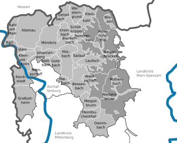

(Population figures as of December 31, 2019)
Unregulated areas (197.56 km², uninhabited)
|
Other communities
|
|
Municipalities of the district before the territorial reform 1971/78
Before the regional reform, the district of Aschaffenburg had 32 municipalities (see list below). (The churches that still exist today are written in bold ):
| former parish | today's parish | today's district |
|---|---|---|
| Dörrmorsbach | Haibach | Aschaffenburg district |
| Gailbach | Aschaffenburg | Aschaffenburg |
| Glattbach | Glattbach | Aschaffenburg district |
| Goldbach | Goldbach | Aschaffenburg district |
| Großostheim | Großostheim | Aschaffenburg district |
| Grünmorsbach | Haibach | Aschaffenburg district |
| Haibach | Haibach | Aschaffenburg district |
| Grove in the Spessart | Laufach | Aschaffenburg district |
| Heigenbrücken | Heigenbrücken | Aschaffenburg district |
| Heimbuchenthal | Heimbuchenthal | Aschaffenburg district |
| Hessenthal | Mespelbrunn | Aschaffenburg district |
| Hösbach | Hösbach | Aschaffenburg district |
| Johannesberg | Johannesberg | Aschaffenburg district |
| Wedge Mountain | Bessenbach | Aschaffenburg district |
| Kleinostheim | Kleinostheim | Aschaffenburg district |
| Krausenbach | Dammbach | Aschaffenburg district |
| Laufach | Laufach | Aschaffenburg district |
| Mainaschaff | Mainaschaff | Aschaffenburg district |
| Mespelbrunn | Mespelbrunn | Aschaffenburg district |
| Oberafferbach | Johannesberg | Aschaffenburg district |
| Oberbessenbach | Bessenbach | Aschaffenburg district |
| Obernau | Aschaffenburg | Aschaffenburg |
| Sailauf | Sailauf | Aschaffenburg district |
| Steinbach | Johannesberg | Aschaffenburg district |
| Stockstadt am Main | Stockstadt am Main | Aschaffenburg district |
| Straßbessenbach | Bessenbach | Aschaffenburg district |
| Unterafferbach | Goldbach | Aschaffenburg district |
| Waldaschaff | Waldaschaff | Aschaffenburg district |
| Weibersbrunn | Weibersbrunn | Aschaffenburg district |
| Wenighösbach | Hösbach | Aschaffenburg district |
| Wintersbach | Dammbach | Aschaffenburg district |
| Winzenhohl | Hösbach | Aschaffenburg district |
Protected areas
There are 13 nature reserves , seven landscape protection areas , 36 geotopes and six designated FFH areas in the district . (As of August 2016)
See also:
- List of nature reserves in the Aschaffenburg district
- List of landscape protection areas in the Aschaffenburg district
- List of FFH areas in the Aschaffenburg district
- List of geotopes in the Aschaffenburg district
License Plate
On July 1, 1956, the district was assigned the distinguishing mark AB when the license plates that are still valid today were introduced . It is still issued today.
Until the 1990s, vehicles from the old district of Alzenau received license plates with the letter pairs KA to NZ and the numbers from 100 to 999.
Since July 11, 2013, the distinctive sign ALZ (Alzenau) has also been available.
Web links
- Official website of the district of Aschaffenburg
- Aschaffenburg district . In: Bayern-Infos.de
- Aschaffenburg district . In: Bayern-im-Web.de
- Literature from and about the district of Aschaffenburg in the catalog of the German National Library
- Entry on the coat of arms of the district of Aschaffenburg in the database of the House of Bavarian History
Individual evidence
- ↑ "Data 2" sheet, Statistical Report A1200C 202041 Population of the municipalities, districts and administrative districts 1st quarter 2020 (population based on the 2011 census) ( help ).
- ^ Wilhelm Volkert (ed.): Handbook of Bavarian offices, communities and courts 1799–1980 . CH Beck, Munich 1983, ISBN 3-406-09669-7 , p. 422 .
- ^ Wilhelm Volkert (ed.): Handbook of Bavarian offices, communities and courts 1799–1980 . CH Beck, Munich 1983, ISBN 3-406-09669-7 , p. 97 .
- ^ Aschaffenburg district, 2020 district election, result , accessed on May 2, 2020
- ↑ http://www.main-netz.de/nachrichten/region/aschaffenburg/aschaffenburg-land/land/art3986,367063
- ^ Entry on the coat of arms of the Aschaffenburg district in the database of the House of Bavarian History , accessed on September 4, 2017 .
- ↑ "Data 2" sheet, Statistical Report A1200C 202041 Population of the municipalities, districts and administrative districts 1st quarter 2020 (population based on the 2011 census) ( help ).
- ^ Michael Rademacher: German administrative history from the unification of the empire in 1871 to the reunification in 1990. aschaffenburg.html. (Online material for the dissertation, Osnabrück 2006).
Districts:
Aichach-Friedberg |
Altötting |
Amberg-Sulzbach |
Ansbach |
Aschaffenburg |
Augsburg |
Bad Kissingen |
Bad Toelz-Wolfratshausen |
Bamberg |
Bayreuth |
Berchtesgadener Land |
Cham |
Coburg |
Dachau |
Deggendorf |
Dillingen on the Danube |
Dingolfing-Landau |
Danube Ries |
Ebersberg |
Eichstätt |
Erding |
Erlangen-Höchstadt |
Forchheim |
Freising |
Freyung-Grafenau |
Fürstenfeldbruck |
Fürth |
Garmisch-Partenkirchen |
Gunzburg |
Hatred Mountains |
Yard |
Kelheim |
Kitzingen |
Kronach |
Kulmbach |
Landsberg am Lech |
Landshut |
Lichtenfels |
Lindau (Lake Constance) |
Main-Spessart |
Miesbach |
Miltenberg |
Mühldorf am Inn |
Munich |
Neuburg-Schrobenhausen |
Neumarkt in the Upper Palatinate |
Neustadt an der Aisch-Bad Windsheim |
Neustadt an der Waldnaab |
Neu-Ulm |
Nuremberg Country |
Oberallgäu |
Ostallgäu |
Passau |
Pfaffenhofen an der Ilm |
Rain |
Regensburg |
Rhön-Grabfeld |
Rosenheim |
Roth |
Rottal-Inn |
Schwandorf |
Schweinfurt |
Starnberg |
Straubing Arch |
Tirschenreuth |
Traunstein |
Unterallgäu |
Weilheim-Schongau |
Weißenburg-Gunzenhausen |
Wunsiedel in the Fichtel Mountains |
Wurzburg
Independent cities:
Amberg |
Ansbach |
Aschaffenburg |
Augsburg |
Bamberg |
Bayreuth |
Coburg |
Erlangen |
Fürth |
Hof (Saale) |
Ingolstadt |
Kaufbeuren |
Kempten (Allgäu) |
Landshut |
Memmingen |
Munich |
Nuremberg |
Passau |
Regensburg |
Rosenheim |
Schwabach |
Schweinfurt |
Straubing |
Willows in the Upper Palatinate |
Wurzburg