
District of Oberallgäu
| coat of arms | Germany map |
|---|---|

|

Coordinates: 47 ° 34 ' N , 10 ° 16' E |
| Basic data | |
| State : | Bavaria |
| Administrative region : | Swabia |
| Administrative headquarters : | Sonthofen |
| Area : | 1,528 km 2 |
| Residents: | 156,008 (Dec. 31, 2019) |
| Population density : | 102 inhabitants per km 2 |
| License plate : | OA |
| Circle key : | 09 7 80 |
| NUTS : | DE27E |
| Circle structure: | 28 municipalities |
| Address of the district administration: |
Oberallgäuer Platz 2 87527 Sonthofen |
| Website : | |
| District Administrator : | Indra Baier-Müller ( Free Voters ) |
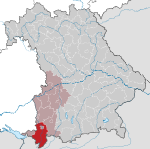
| Location of the Oberallgäu district in Bavaria | |
  |
|
The Oberallgäu district is the southernmost district in Germany and belongs to the Bavarian administrative district of Swabia . The independent city of Kempten (Allgäu) is located in the middle of the district. Oberallgäu is mistakenly used as a synonym for the Upper Allgäu , which is characterized by the Alps, the actual original Allgäu from Oberstaufen, via Oberstdorf and Sonthofen to Bad Hindelang, where the Allgäu dialects are also at home. The pre-alpine hill country extending from Kempten to the north is in turn referred to as Unterallgäu , even if it belongs to the Oberallgäu district and Swabian dialects are increasingly spoken there from Kempten . Only north of Dietmannsried runs Unterallgäu .
geography

location
The Oberallgäu district is the southernmost district in Germany. The area of the district includes alpine and pre-alpine terrain. The highest mountain is the Hochfrottspitze ( 2649 m ). The lowest point in the district is on the Iller near Fluhmühle in the municipality of Altusried ( 622 m ). The most famous gorge is the Breitachklamm , through which the Breitach flows. This rises in neighboring Austria, reaches German territory at the Walserschanze and then flows further north. At the source of the Iller near Oberstdorf, it forms together with the Stillach and Trettach the Iller, which also flows through the entire district in a northerly direction and leaves it at Altusried in the direction of Memmingen .
In the district including Kempten, 50.3 percent of the total area is used as agricultural land.
Neighboring areas

The district borders clockwise in the west, beginning with the district of Lindau (Lake Constance) (in Bavaria), the district of Ravensburg (in Baden-Württemberg ) and the districts of Unterallgäu and Ostallgäu (both again in Bavaria). In the south it borders on Austria .
history
Regional courts
Before 1800, the area of the Oberallgäu district belonged to different dominions. The north belonged predominantly to the Prince Abbey of Kempten , the Free Imperial City of Kempten and the Hochstift Augsburg , the south-west formed the formerly independent county of Königsegg-Rothenfels . It briefly belonged to Austria from January 1804 to December 1805 , after which it became part of the Kingdom of Bavaria through the Treaty of Brno . In 1804 the district courts of Kempten and Sonthofen were established, in 1806 the district court of Immenstadt was established . In 1809 the city of Kempten became an immediate district. All administrative areas initially belonged to the Illerkreis , from 1817 to the Oberdonaukreis , which was renamed Swabia and Neuburg (later just Swabia ) in 1838 . This administrative reorganization also resulted in the rise of the former Augsburg markets of Oberstdorf , Bad Hindelang and Sonthofen , whereby the latter was able to develop into an administrative center. The former Rothenfels residence town of Immenstadt, on the other hand, increasingly lost its political influence and importance, especially in the second half of the 19th century.
District Offices
On February 24, 1862 , the district courts of Immenstadt and Sonthofen were combined to form the Sonthofen district office, and the district office of the same name emerged from the Kempten district office.
Counties

On January 1, 1939, the designation district was introduced as everywhere else in the German Reich . The district offices became the districts of Kempten (Allgäu) and Sonthofen.
District of Oberallgäu
As part of the regional reform in Bavaria , on July 1, 1972, most of the Kempten (Allgäu) district was combined with the Sonthofen district to form the new Oberallgäu district . The two communities of Sankt Lorenz and Sankt Mang in the Kempten district were incorporated into the independent city of Kempten. Today the Oberallgäu district consists of 28 communities.
Population development
The Oberallgäu district gained more than 20,000 inhabitants between 1989 and 2008 or grew by around 16%. From 2005 onwards the development was slightly down. Between 1988 and 2018 the district grew from 130,054 to 155,362 by 25,308 inhabitants or by 19.5%.
The following figures refer to the territorial status on May 25, 1987.
| Population development | ||||||||||||||
|---|---|---|---|---|---|---|---|---|---|---|---|---|---|---|
| year | 1840 | 1900 | 1939 | 1950 | 1961 | 1970 | 1987 | 1991 | 1995 | 2000 | 2005 | 2010 | 2015 | |
| Residents | 50,802 | 59,190 | 80,316 | 111,940 | 106,334 | 119,625 | 128,665 | 139,379 | 144,637 | 147.405 | 150.507 | 149.926 | 152.672 | |
politics
District council
The district council consists of 70 members who, according to the results of the local elections on March 15, 2020, are divided between the following parties and voter communities (with comparative figures from the 2014 election):
| Party / list | 2020 election | Election 2014 | |
|---|---|---|---|
| Seats | Seats | ||
| CSU | 24 | 30th | |
| GREEN | 14th | 9 | |
| SPD | 3 | 6th | |
| ÖDP / Independent Citizens | 2 | 2 | |
| FDP | 2 | 2 | |
| AfD | 2 | 0 | |
| REP | - | 1 | |
| Free voters (FW) | 16 | 16 | |
| List Young Upper Allgäu (LJOA) | 5 | 4th | |
| Citizens' Alliance Oberallgäu | 2 | 0 | |
| total | 70 | 70 |
District Administrator
Anton Klotz (CSU) has been the district administrator since May 1, 2014. The deputies are in their order: Alois Ried (CSU), Gertrud Knoll (CSU), Roman Haug (Free Voters), Ulrike Hitzler (Alliance 90 / The Greens). In the local elections in March 2020 , a woman was elected for the first time in the runoff election against the favored Alfons Hörmann with Indra Baier-Müller (Free Voters).
Previous district administrators with their first deputies were:
| Years of office | District Administrator | Deputy |
|---|---|---|
| 2020-2026 | Indra Baier-Müller (Free Voters) | |
| 2014-2020 | Anton Klotz (CSU) | Alois Ried (CSU) |
| 2008-2014 | Gebhard Kaiser (CSU) | Anton Klotz (CSU) |
| 1996-2008 | Gebhard Kaiser (CSU) | Herbert Seger (CSU) |
| 1984-1995 | Hubert Rabini (CSU) | Gebhard Kaiser (CSU) |
| 1978-1984 | Hubert Rabini (CSU) | Anton Gschwend (CSU) |
| 1972-1988 | Theodor Rössert (CSU) | Anton Gschwend (CSU) |
Before 1972, the district administrators were divided into those of the districts of Kempten (Allgäu) and Sonthofen .
coat of arms
|
|
Blazon : “Split between red and gold; in front under the shield head divided by red and blue a growing, silver rock mountain, behind one another three striding, looking, red armored black lions. " |
|
Justification for the coat of arms: The silver triangle symbolizes the Allgäu main ridge; the Hohenstaufen lions are a reminder of belonging to the Duchy of Swabia.
See also: https://www.gesetze-bayern.de/Content/Document/BayLKrO-3 |
economy
In October 2018, the unemployment rate in the Oberallgäu district was 1.9%.
traffic
Street
The Oberallgäu is connected to the A 7 . There are a total of seven runs in the district. The autobahn ended at Nesselwang ( Ostallgäu ) until September 1, 2009 . After decades of legal dispute, the last section to Füssen (Ostallgäu) was opened. The expansion of this section was very controversial, as the route runs through nature reserves and moors. At motorway junction Allgäu near Kempten 5 kilometer begins A980 .
Furthermore, three federal highways run through the district, federal road 19 from Kempten to Austria in north-south direction and federal road 12 from Kempten via Weitnau in east-west direction. The federal highway 308 also leads from Lindau in a west-east direction to the Austrian border and is the western part of the German Alpine Road .
The former federal road 309, which was downgraded to state road 2520 on January 1, 2016, runs parallel to the A 7 and ends at the Austrian border near Pfronten .
railroad
The state-owned Ludwigs-Süd-Nord-Bahn reached the city of Kempten from Buchloe ( Ostallgäu ) in 1852 and was continued in sections via Immenstadt to Lindau in the following year.
In 1863 the Illertalbahn of the city of Memmingen from Memmingen to Kempten was opened. In Immenstadt, the branch line to Sonthofen , built by the Bavarian State Railways , has been branching off since 1873, which was extended to Oberstdorf in 1888 by the Munich Local Railroad Company .
The state railway from Kempten to Pfronten began operations in 1895 and has continued to Reutte in Tyrol since 1905. The connection from the Württemberg Allgäu to Isny was established in 1909 by a particularly scenic local railway from Kempten via Sibratshofen. This line was closed for passenger traffic in 1983/84. A railway network of 117 km in length remained.
The Kempten main station was initially a terminus , which since 1907 could be bypassed by a bypass. Express trains usually only stopped at the Kempten- Hegge station until a new through station replaced the old main station in 1969.
Waterways
There are no navigable waterways in the Oberallgäu. The Iller has the largest river too little depth and too many barrages .
Cycle path network
Three important cycle paths and at the same time parts of long-distance cycle paths of the Bavarian cycle path network as well as two routes for mountain bikes lead through the district of Oberallgäu:
- The Iller cycle path runs through the district from south to east.
- The Bodensee-Königssee-Radweg guides cyclists from west to east through the district.
- The Allgäu cycle path in turn runs in the northern part of the district from west to east.
- The Heckmair route and the Joe route are mountain bike routes that lead south out of the district to Austria.
Communities
(Residents on December 31, 2019)
|
Other communities
|
  |
See also
Architectural monuments
See architectural monuments in the Oberallgäu district
Protected areas
Nature and landscape protection areas
There are 10 nature reserves and 23 landscape protection areas in the Oberallgäu district .
Geotopes
In the district there are 85 (as of August 2016) designated geotopes by the Bavarian State Office for the Environment .
License Plate
On August 5, 1974, the district was assigned the SF , which had been valid since July 1, 1956 for the Sonthofen district. On February 12, 1979 it was replaced by the distinctive sign OA, which is still valid today .
Vehicles from the Altlandkreis Kempten (Allgäu) received special identification numbers. With the abbreviation OA , they received license plates with the letter pairs AA to ZZ and the numbers from 100 to 999 until the 1990s.
literature
- Norbert Herrmann: Kempten and the Oberallgäu. Pictures from the history of the city and the district. 2nd expanded edition, Verlag für Heimatpflege im Heimatbund Allgäu, Kempten (Allgäu) 1984 (title of the 1st edition 1963: Kempter History Book ).
- Gerhard Willi (Hrsg.): Folklore and regional studies from the districts of Lindau and Oberallgäu with Kempten - the physics reports of the city and regional courts of Lindau, Weiler, Kempten, Immenstadt and Sonthofen (1858-1861) ISBN 978-3-95786- 036-1
Web links
- Official website of the district
- District tourism website
- Literature from and about the Oberallgäu district in the catalog of the German National Library
- Entry on the coat of arms of the Oberallgäu district in the database of the House of Bavarian History
Individual evidence
- ↑ a b sheet "Data 2", Statistical Report A1200C 202041 Population of the municipalities, districts and administrative districts 1st quarter 2020 (population based on the 2011 census) ( help ).
- ↑ Source: Statistics for the EUREGIO Lake Constance. In: Listed! The ten districts of the Lake Constance region… In: Südkurier from February 25, 2011 and in: Ders. dated July 2, 2011
- ↑ Reference library of the Bavarian citizen: Or collection ..., Volume 6 . Karl Kollman'sche Buchhandlung, Augsburg 1862, p. 275 to 286 .
- ^ Wilhelm Volkert (ed.): Handbook of Bavarian offices, communities and courts 1799–1980 . CH Beck, Munich 1983, ISBN 3-406-09669-7 , p. 97 .
- ^ Ordinance on the reorganization of Bavaria into rural districts and independent cities of December 27, 1971
- ↑ Election of the district council in the Oberallgäu district, overall result , accessed on April 27, 2020
- ↑ Entry on the coat of arms of the Oberallgäu district in the database of the House of Bavarian History , accessed on September 5, 2017 .
Districts:
Aichach-Friedberg |
Altötting |
Amberg-Sulzbach |
Ansbach |
Aschaffenburg |
Augsburg |
Bad Kissingen |
Bad Toelz-Wolfratshausen |
Bamberg |
Bayreuth |
Berchtesgadener Land |
Cham |
Coburg |
Dachau |
Deggendorf |
Dillingen on the Danube |
Dingolfing-Landau |
Danube Ries |
Ebersberg |
Eichstätt |
Erding |
Erlangen-Höchstadt |
Forchheim |
Freising |
Freyung-Grafenau |
Fürstenfeldbruck |
Fürth |
Garmisch-Partenkirchen |
Gunzburg |
Hatred Mountains |
Yard |
Kelheim |
Kitzingen |
Kronach |
Kulmbach |
Landsberg am Lech |
Landshut |
Lichtenfels |
Lindau (Lake Constance) |
Main-Spessart |
Miesbach |
Miltenberg |
Mühldorf am Inn |
Munich |
Neuburg-Schrobenhausen |
Neumarkt in the Upper Palatinate |
Neustadt an der Aisch-Bad Windsheim |
Neustadt an der Waldnaab |
Neu-Ulm |
Nuremberg Country |
Oberallgäu |
Ostallgäu |
Passau |
Pfaffenhofen an der Ilm |
Rain |
Regensburg |
Rhön-Grabfeld |
Rosenheim |
Roth |
Rottal-Inn |
Schwandorf |
Schweinfurt |
Starnberg |
Straubing Arch |
Tirschenreuth |
Traunstein |
Unterallgäu |
Weilheim-Schongau |
Weißenburg-Gunzenhausen |
Wunsiedel in the Fichtel Mountains |
Wurzburg
Independent cities:
Amberg |
Ansbach |
Aschaffenburg |
Augsburg |
Bamberg |
Bayreuth |
Coburg |
Erlangen |
Fürth |
Hof (Saale) |
Ingolstadt |
Kaufbeuren |
Kempten (Allgäu) |
Landshut |
Memmingen |
Munich |
Nuremberg |
Passau |
Regensburg |
Rosenheim |
Schwabach |
Schweinfurt |
Straubing |
Willows in the Upper Palatinate |
Wurzburg
Altusried | Bad Hindelang | Balderschwang | Betzigau | Blaichach | Bolsterlang | Buchenberg | Burgberg im Allgäu | Dietmannsried | Durach | Fishing in the Allgäu | Haldenwang | Immenstadt im Allgäu | Arbors | Missen-Wilhams | Obermaiselstein | Oberstaufen | Oberstdorf | Ofterschwang | Oy-Mittelberg | Rettenberg | Sonthofen | Sulzberg | Waltenhofen | Weitnau | Wertach | Wiggensbach | Wildpoldsried
Unregulated areas:
Kempter Wald