
Waltenhofen
| coat of arms | Germany map | |
|---|---|---|

|
Coordinates: 47 ° 40 ' N , 10 ° 18' E |
|
| Basic data | ||
| State : | Bavaria | |
| Administrative region : | Swabia | |
| County : | Oberallgäu | |
| Height : | 722 m above sea level NHN | |
| Area : | 59.76 km 2 | |
| Residents: | 9482 (Dec. 31, 2019) | |
| Population density : | 159 inhabitants per km 2 | |
| Postal code : | 87448 | |
| Primaries : | 08303, 0831 | |
| License plate : | OA | |
| Community key : | 09 7 80 143 | |
| Community structure: | 81 parts of the community | |
| Address of the municipal administration: |
Rathausstrasse 4 87448 Waltenhofen |
|
| Website : | ||
| Mayor : | Eckhard Harscher (We for Waltenhofen) | |
| Location of the municipality of Waltenhofen in the Oberallgäu district | ||
  |
||


Waltenhofen is a municipality in the Swabian district of Oberallgäu in Bavaria . The core community is around seven kilometers south of Kempten (Allgäu) .
geography
Expansion of the municipal area
The municipality consists of the districts Waltenhofen, Martinszell i. Allgäu, Memhölz and Niedersonthofen.
Waltenhofen has 81 officially named parts of the municipality (the type of settlement is given in brackets ):
|
|
|
|
Coats of arms of the districts

Martinszell

Memholz

Niedersonthofen


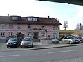
Vicarage in Waltenhofen
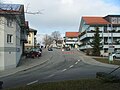
Rathausstrasse in Waltenhofen
Rabbits with Martin's fountain


Protected areas
The following nature reserves are largely located in the municipality of Waltenhofen:
- " Rohrbachtobel in the Wirlinger Forest ": The nature reserve, designated in 1959, is located west of Waltenhofen and covers 14 hectares.
- " Widdumer Weiher ": The nature reserve, designated in 1997, is located east of Martinszell near the hamlet of Widdum and covers 30 hectares.
history
History of the parish
- Waltenhofen: The castle of the local family once stood on the Schloßbühl in Waltenhofen , which cannot be documented. Later the gentlemen from Horben zu Waltenhofen sat here. Their property with the castle stables and the town of Waltenhofen were bought by the lords of Rauns-Fischen in 1367, who remained local lords until they died out in 1450. In 1465 Hans von Werdenstein bought the inheritance of Hans von Rauns zu Waltenhofen, St. Veit and Rauns. Waltenhofen later belonged to the prince monastery of Kempten . Since secularization and the Reichsdeputationshauptschluss of 1803, the place belongs to Bavaria . In the course of the administrative reforms in the Kingdom of Bavaria , today's municipality was created with the municipal edict of 1818 . The war memorial was inaugurated in 1923 .
- Hegge : To the north of Waltenhofen is the industrial town of Hegge, which used to belong to the Kempten monastery area. The oldest document about Hegge that has been found to date dates from 1543.
- Martinszell : Martinszell lies in the middle between Kempten and Immenstadt. In 1275 a parish "Cella Sancti Martini" is mentioned. In 1430 Martinszell received lower jurisdiction , in 1485 the village was taken over by Emperor Friedrich III. raised to the market. Matthias Waibel was born in Martinszell in the late 15th century . He was vicar in Kempten and disseminated Martin Luther's theses at the time of the Peasant Wars and died as a martyr in 1525. In the same year, on October 25, 1525, the "Martinszeller Treaty" was signed between the peasantry and Prince Abbot Sebastian von Breitenstein in the local rectory .
- Memhölz : Memhölz is a very old parish that had a pastor as early as 1200. The house of the Schoenstatt Movement family is located in Memhölz .
- Niedersonthofen : From 1243 to 1804, Niedersonthofen belonged to the imperial county of Königsegg-Rothenfels and was thus more oriented towards Immenstadt , in contrast to Waltenhofen, which belonged to the prince monastery of Kempten . Niedersonthofen is located on the Niedersonthofener See , which was much larger in ancient times, so that Niedersonthofen Castle, which was only rediscovered in 1952, was designed as a moated castle. The small village of Linsen , which belongs to Niedersonthofen, has a castle mentioned in 1319, of which only the castle hill with a memorial plaque can be seen on the spot. The remarkable chapel is dated to the 14th century.

Incorporations
On January 1, 1972, the previously independent municipality of Memhölz was incorporated. On January 1, 1976, Niedersonthofen was added. Martinszell in Allgäu followed on April 1, 1976.
Population development
Between 1988 and 2018, the community grew from 8042 to 9340 by 1298 inhabitants or 16.1%.
Bavarian State Office for Statistics:
| year | 1840 | 1871 | 1900 | 1925 | 1950 | 1961 | 1970 | 1987 | 1995 | 2005 | 2010 | 2015 |
| Residents | 3148 | 3123 | 3454 | 4263 | 6876 | 6782 | 8031 | 7969 | 8616 | 8922 | 8873 | 9066 |
politics
Municipal council
The municipal council has 20 members, who after the local elections on March 15, 2020 will be divided between the following parties and electoral associations:
| Party / list | Be right % | Seats | +/- |
| Christian Social Union in Bavaria (CSU) | 34.06% | 7th | - 1 |
| Alliance 90 / The Greens (Greens) | 21.69% | 5 | + 2 |
| Social Democratic Party of Germany (SPD) | 7.09% | 1 | - 1 |
| Free voters (FW) | 20.48% | 4th | ± 0 |
| We for Waltenhofen (WfW) | 16.68% | 3 | ± 0 |
mayor
Eckhard Harscher (We for Waltenhofen) has been the first mayor of Waltenhofen since 2006. His predecessor in office was Robert Wegscheider (CSU). In the mayoral election on March 11, 2012, he was confirmed in his office with 67.2% of the votes. In the mayoral election on March 4, 2018, he was again confirmed in office with 68.2% of the valid votes. The turnout was 58.1 percent.
Economy and Infrastructure
economy
According to official statistics, there were 19 employees in the field of agriculture and forestry, 1059 in the manufacturing sector and 408 in trade, transport and hospitality at the place of work. In other economic sectors, 705 people were employed at the place of work subject to social security contributions. There were a total of 3,683 employees at the place of residence subject to social security contributions. There were six companies in the manufacturing sector and 17 in the construction sector.
Agriculture and Forestry
With 3633 hectares, around 61 percent of the Waltenhofen municipality is used for agriculture, primarily as permanent grassland . In 2016 there were 131 farms in Waltenhofen, most of which are dairy farmers. Another 1143 hectares or almost 20 percent of the municipal area are forested.
education
There are the following educational institutions (as of 2018):
- six day-care centers with 393 approved kindergarten places and 351 children in care
- four primary and secondary schools with 25 teachers and 357 students (school year 2017/18)
traffic
The Martinszell stop in the Oberdorf district is on the Bavarian Allgäu Railway from Munich to Lindau and is served by Deutsche Bahn passenger transport. Because a number of passengers destined for Oberstdorf got off there by mistake, it was renamed Martinszell at the end of the 1960s. There are continuous connections to Oberstdorf , Memmingen , Ulm , Munich, Nuremberg , Augsburg and Lindau.
The Waltenhofen station was shut down in 1984.
Waltenhofen is located at the “Junction Waltenhofen” at the transition from the A 980 to the B 12 .
Buildings
St. Martin and Alexander (Waltenhofen)
The church in the middle of Waltenhofen was built from 1765 to 1770 as a hall with a retracted choir, the core of the tower is still late medieval, the upper floor of the tower from 1901.

Exterior view
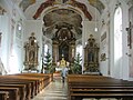
Church interior


St. Cosmas and Damian (Rauns)
The church of Rauns is located south-east of Waltenhofen. It is dedicated to Saints Cosmas and Damian. Built around 1250 by the Lords of Rauns, it has belonged to those of Werdenstein since 1464. In 1548 it came into the possession of the evangelical imperial city of Kempten and therefore became Zwinglian. Already in 1548 the church was acquired by the Kempten monastery and merged with the parish of Waltenhofen. In 1808 the Bavarian state left them to the 26 farmers of Rauns. The church had been owned by the municipality of Waltenhofen since 1936 and was returned to the parish of St. Martin in 1962. The figures of saints, including a figure of Saint Vitus, date from the 13th to 15th centuries; some are ascribed to J. Syrlin the Younger. The altars were built around 1700.
.jpg)
.jpg)

Mary, Queen of the Apostles (Hegge)
Hegge is about thirty minutes on foot or three minutes by car from the parish village of Waltenhofen. At the end of the 1940s, unemployed people were recruited to build churches. The building material comes from the people quarry. The church was consecrated on August 19, 1951. The outer facade is characterized by the gray quarry stone. The interior is designed in neo-Gothic, Art Nouveau and modern styles.


Evangelical Church of Waltenhofen
The new Evangelical Lutheran Church in Waltenhofen was inaugurated in October 2000. Before that, the services took place in the Heggen rectory or in an emergency church in Rauns. The new community center on Dietrich-Bonhoeffer-Straße was built according to an ecologically very ambitious concept. The simple deep red triptych in the chancel also attracts a lot of attention.

Evangelical Church Waltenhofen with bell bearer

Baptismal bowl, baptistery in the Protestant church Waltenhofen

Altarpiece of the Protestant Church of the Resurrection in Waltenhofen


Personalities
- Hans Kurz (* around 1550 in Memhölz –1608), master builder during the Renaissance
- Matthias Waibel (late 15th century – 1525), reformer and martyr
- Georg Schädler (born June 10, 1887 in Gopprechts (zu Niedersonthofen ), † February 14, 1971 in Niedersonthofen), politician ( NSDAP ), member of the state and Reichstag
- Karl Nold (born January 28, 1903; † November 27, 2008), Catholic priest, honorary dean, honorary citizen of Waltenhofen, initiator and builder of the Catholic Church in Hegge
- Franz Hößler (1906–1945), SS leader and protective custody camp leader in Auschwitz , Mittelbau and Bergen-Belsen .
- Ludwig Martin (1909-2010), German lawyer, federal prosecutor from 1963 to 1974
- Herta Huber (* 1926), German writer, lives in the Martinszell district
- Adi Sprinkart (1953–2013), organic farmer and Member of Parliament for the Greens, born and died in the hamlet of Gopprechts
- Wolfgang Dürheimer (* 1958), German manager, President of Bugatti and CEO of Bentley
literature
- Waltenhofen yesterday and today. Chronicle of Waltenhofen by Erich Knoll, 2005, PVB 2006.11767
Web links
- Entry on the coat of arms of Waltenhofen in the database of the House of Bavarian History
Individual evidence
- ↑ "Data 2" sheet, Statistical Report A1200C 202041 Population of the municipalities, districts and administrative districts 1st quarter 2020 (population based on the 2011 census) ( help ).
- ^ Community Waltenhofen in the local database of the Bavarian State Library Online . Bavarian State Library, accessed on August 15, 2019.
- ^ Government of Swabia: NSG Rohrbachtobel in the Wierlinger Forest
- ^ Government of Swabia: NSG Widdumer Weiher
- ^ Wilhelm Volkert (ed.): Handbook of Bavarian offices, communities and courts 1799–1980 . CH Beck, Munich 1983, ISBN 3-406-09669-7 , p. 496 .
- ^ Federal Statistical Office (ed.): Historical municipality directory for the Federal Republic of Germany. Name, border and key number changes in municipalities, counties and administrative districts from May 27, 1970 to December 31, 1982 . W. Kohlhammer, Stuttgart / Mainz 1983, ISBN 3-17-003263-1 , p. 795 .
- ↑ Municipal statistics 2014, Waltenhofen municipality, p. 6
- ↑ Results of the municipal council election 2020 , accessed on May 9, 2020
- ↑ Results of the mayoral election 2006
- ↑ Results of the mayoral election 2012
- ^ Result of the mayoral election 2018 - Waltenhofen
- ↑ Bavarian State Office for Statistics: Statistics communal 2014, Waltenhofen municipality, p. 12f
- ↑ Bavarian State Office for Statistics: Statistics communal 2014, Waltenhofen municipality, p. 15f
- ↑ a b Roman Dilken: Route Portrait ( Memento of 17 October 2018 Internet Archive ). In: kbs970.de .
- ↑ On the death of Karl Nold ( page no longer available , search in web archives ) Info: The link was automatically marked as defective. Please check the link according to the instructions and then remove this notice. Allgäuer Zeitung of December 3, 2008, accessed June 13, 2011

Altusried | Bad Hindelang | Balderschwang | Betzigau | Blaichach | Bolsterlang | Buchenberg | Burgberg im Allgäu | Dietmannsried | Durach | Fishing in the Allgäu | Haldenwang | Immenstadt im Allgäu | Arbors | Missen-Wilhams | Obermaiselstein | Oberstaufen | Oberstdorf | Ofterschwang | Oy-Mittelberg | Rettenberg | Sonthofen | Sulzberg | Waltenhofen | Weitnau | Wertach | Wiggensbach | Wildpoldsried
Unregulated areas:
Kempter Wald