
Niedersonthofener See
| Niedersonthofener See | ||
|---|---|---|

|
||
| Niedersonthofener See | ||
| Geographical location | District of Oberallgäu | |
| Tributaries | Dorfbach Schrattenbach Hasenlohbach (all west) Seebach (southeast) |
|
| Drain | (Oberinselsee) → Mittelinselsee → Unterinselsee → → Seebach → Waltenhofener Bach → Iller |
|
| Places on the shore | Martinszell Niedersonthofen Oberdorf districts of Waltenhofen |
|
| Location close to the shore | Waltenhofen , Kempten (Allgäu) | |
| Data | ||
| Coordinates | 47 ° 38 '6 " N , 10 ° 15' 53" E | |
|
||
| Altitude above sea level | 703.3 m above sea level NHN | |
| surface | 1.35 km² | |
| length | 2.73 km | |
| width | 580 m | |
| volume | 13,500,000 m³ | |
| Maximum depth | 21.3 m | |
| Middle deep | 10.0 m | |
| PH value | 7.9 | |
|
particularities |
two smaller neighboring lakes (downstream): |
|

The Niedersonthofener See is a lake in the Oberallgäu district in Bavaria .
It has formed in a channel that a tongue of the Iller glacier has left in the landscape. The lake is 135.30 hectares in size and drained via the superior Staffelsee (no separate lake but the northeastern portion of the lake Niedersonthofener) Mitterinselsee and Unterinselsee in the Walt Hofener-Bach, who eventually into the Iller flows . Together with these two neighboring lakes, it falls under the umbrella term Sonthofen Lakes, which have a total area of 162 hectares and a volume of 14.818 million cubic meters. The Oberinselsee is separated from the main part of the Niedersonthofener See by a 100 meter wide bottleneck. It is 680 meters long from south to north, and up to 260 meters wide, with an area of 13 hectares. The Schwarze Graben flows into the Mitterinselsee in the west.
The lake is located in the area of the municipality of Waltenhofen . The majority of the lake belongs to the district Martin im Allgäu , while the superior Elsee in the east to the district Memhölz part, which otherwise extends along the north bank. With its narrow west bank, the lake borders the Niedersonthofen district .
The districts Niedersonthofen (west), Oberdorf (south) and cells (north) located right on the lake, at the foot of the 1,063 m high Stoffel Berg lies and water birds such as the mergansers and grebes a hideaway offers. The parish village of Memhölz is located on the Mitterinselsee .
It is suitable for swimming, fishing, rowing, sailing and surfing and has four official bathing areas that can be used free of charge. Two of them, Oberdorf and Niedersonthofen, are equipped with beach volleyball courts. There are also two campsites at Lake Niedersonthofen. A circular hiking trail of about ten kilometers leads along the shore, which turns into litter meadows in the northern part . Numerous plant species that have become rare, such as sundew , marsh stendelwort and water hose, have survived here.
In winter the lake is sometimes used by ice skaters.
island
In Memhölz there is the hamlet Insel , once an island in the now heavily silted lake. There was once a castle of the Prince Abbot of Kempten. In the summer months there is a boat rental there.
Cells
The place name cells refers to a former monk cell. There was a parish church in Zellin on the lakeshore near cells, and in 1356 the place belonged to Linsen as a plaque indicates.
The hamlet cells on Lake Niedersonthofener See

Notice board at cells


photos

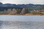
View of Niedersonthofen from the lake, in the background the Stoffelberg
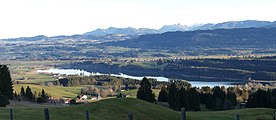
View of the lake from the northwest

View of the "island" in the Niedersonthofen lake


See also
Web links
- Fishing side
- Sailing club on the lake
- http://www.scni-segeln.de
- DLRG at the lake
- http://www.wasserwacht-kempten.de