
Wiggensbach
| coat of arms | Germany map | |
|---|---|---|

|
Coordinates: 47 ° 45 ' N , 10 ° 14' E |
|
| Basic data | ||
| State : | Bavaria | |
| Administrative region : | Swabia | |
| County : | Oberallgäu | |
| Height : | 857 m above sea level NHN | |
| Area : | 31.82 km 2 | |
| Residents: | 5039 (Dec. 31, 2019) | |
| Population density : | 158 inhabitants per km 2 | |
| Postal code : | 87487 | |
| Area code : | 08370 | |
| License plate : | OA | |
| Community key : | 09 7 80 146 | |
| LOCODE : | DE WGB | |
| Market structure: | 75 parts of the community | |
Market administration address : |
Marktplatz 3 87487 Wiggensbach |
|
| Website : | ||
| Mayor : | Thomas Eigstler ( CSU ) | |
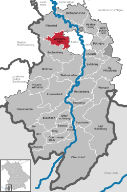
| Location of the Wiggensbach market in the Oberallgäu district | ||
  |
||


Wiggensbach is a market in the Swabian district of Oberallgäu . In addition to the market, the community also consists of the districts Ermengerst and Westenried . Since 1971 the community has been a state-recognized resort .
The first settlement of the Ermengerst part of the municipality is documented for the year 1037, the place Wiggensbach for 1182. The Wiggensbach treasure found in 1888 , whose coins can be dated to the 1st to 3rd centuries, shows that people settled in what is now the municipality shortly after the turn of the century.
geography


Geographical location
The Wiggensbach market is immediately adjacent about eight kilometers west of Kempten (Allgäu) .
Besides Kempten, neighboring communities are Buchenberg in the south and Altusried in the north. To the southwest is the Kürnacher Forest and to the west-northwest is the Hohentanner Forest , both of which are still partly in the municipality.
The municipality includes surveys of the Alpine foothills . Almost all altitudes are populated with individual hamlets.
Community structure
Wiggensbach has 75 officially named parts of the municipality (the type of settlement is given in brackets ):
|
|
|
|
The community area is located between 750 and 1077 m above sea level. NN (Dürrer Bühl, see also Blender (Berg) ). The highest district of Raunberg is at an altitude of 1013 m above sea level. NHN . The total area of 31.83 square kilometers is divided according to the type of use as follows:

| surface | Size in hectares |
Share of total area in% |
|---|---|---|
| Operating area | 1 | 0.0 |
| Areas of other use | 3 | 0.1 |
| Water surface | 15th | 0.5 |
| Recreation area | 18th | 0.6 |
| traffic area | 92 | 2.9 |
| Building and open space | 152 | 4.8 |
| Forest area | 935 | 29.4 |
| Agricultural area | 1966 | 61.8 |
The total settlement and traffic area accounts for a total of around 8.3 percent with a size of 264 hectares.
climate
For Wiggensbach there was a measuring station for precipitation in the hamlet of Schachen from 1951 to 2000, this was at an altitude of 755 meters. Since the station only recorded precipitation and no temperatures, no precise information can be given about the climatic conditions for the community. The next comparison option is offered by the values measured in Kempten .
In this comparison, Wiggensbach, with average precipitation of 1,487 millimeters, is significantly higher than the values of Kempten (1,272 millimeters); due to the higher location, it can also be assumed that the average temperature is lower than the 6.9 degrees Celsius measured in Kempten. Wiggensbach is climatically in the temperate zone , in summer as well as in winter weather conditions are often determined by the foehn . Due to the high location of the community area, it snows more in winter than in lower neighboring communities.
Average values of the weather stations in the hamlet of Schachen (information on precipitation) and Kempten (information on temperature) as a long-term average:
|
Monthly average temperatures for Kempten and precipitation for Schachen
|
||||||||||||||||||||||||||||||||||||||||||||||||||||||||||||
history

Antiquity
It is not known whether people had settled in the municipality in ancient times. However, the Wiggensbach treasure find shows that people were already in Wiggensbach in the 3rd century AD. The hoard was discovered in 1888 by farmer's boy Joseph Mayr while herding cows on a field path. Some of the jewelry and coins were exhibited in the Roman Museum in Kempten (Allgäu) . Weapons, tools and jewelry from the Bronze Age were found in the neighboring town of Altusried, and the first settlement before the birth of Christ was found in Kempten. dw A Roman road ran through the municipality from Isny to Altusried; the exact course can no longer be traced today. Remnants of the path were found near a hamlet between Wiggensbach and Ermengerst.
middle Ages
The Ermengerst district was founded before Wiggensbach was officially mentioned for the first time. Due to the patron saint of the church, John the Baptist , it is assumed that Ermengerst originated as an early baptistery in the early Middle Ages. In 1037 the Ermengerster Castle was named as the seat of servants . The name Ermengerst probably comes from an Erminger who signed a certificate. In 1288, among others, a knight of Ermengerst conquered the Iberg fortress.
The place Wiggensbach was first mentioned in 1182 as Witingisbach in the Isny monastery chronicle. The origin of the place name is not clear. One theory says that the name comes from a hermit named Witigo or Witgouvo , who is said to have settled in the Nibelgau in 864 . The other theory comes from the Isny monastery chronicle, in which it says: "Your contributions helped with the construction of the new Isny monastery: the people's priest Martin von Wittingisbach with his congregation ..."
The market Wiggensbach was assigned to the prince monastery of Kempten in 1508 together with other hamlets . Suseck Castle, shown on the municipal coat of arms, was destroyed in 1525. Only the castle stables remain from the castle today .
Modern times

1555 the first desertification took place in Eckartsberg near Wiggensbach ; Houses were built instead of in places in the wilderness and the property was redistributed. The reason for this was the increased risk of fire due to the narrow construction.
Around 1620, the parish of Wiggensbach had 1500 inhabitants. The plague killed 820 people in 1628, more than half of the population. In 1634 the market of the Kempten monastery was relocated to Wiggensbach, in 1670 the weekly market was held there again, before it was finally returned to Kempten three years later. 50 years later, in 1684, the Buchenberger Markt was relocated to Wiggensbach. A fair was probably also held at the parish fair .
The Marienkapelle was built in the Kürnachtal in 1780 on the decision of Prince Abbot Honorius Roth von Schreckenstein .
After the Reichsdeputationshauptschluss and the secularization in 1803, the place belonging to the Kempten Abbey was added to Bavaria.
The years 1850 to 1950


In Wiggensbach there were 28 house dairies in 1851, from which ten cooperative dairies were later formed. The dairy industry is an important economic pillar of the community.
In 1868 the volunteer fire brigade was founded and in 1892 it was divided into the two departments, Wiggensbach and Ermengerst, which still exist today. In 1883 a post office was set up for the first time at a local grocer.

In 1888 the so-called Wiggensbach treasure was discovered. This is a coin find that was buried by the Romans in an attack by the Alemanni around 230 AD . It was brought to light by grazing cows, which removed the ground in a pasture and thus exposed the coins.
A post bus connection was set up in 1898 between Kempten, Rothkreuz (a current district of Kempten), Ermengerst and Wiggensbach. There were now two postmen in town. In 1909 the bus service was stopped because of a new rail connection. In the same year a telephone line from Kempten to Wiggensbach was set up. It was considered the first telephone connection in the Swabian district. In 1909 the railway connection between Kempten and Isny, the so-called Isny-Bähnle , was opened with a stop in the Ermengerst district. This rail connection, once the highest standard-gauge railway in Germany, was discontinued in September 1984.
1912–1914 a new school building was built in Wiggensbach. The first edition of the market paper of the market community Wiggensbach appeared in 1927. It is still the organ of the community for public announcements and notices. In 1928 a second connection to the local public transport system to Kempten was set up, initially with a rental car, later with buses.
The surrounding wall of the former plague cemetery south of Wiggensbach was uncovered in 1935. In 1936 a bathing establishment was opened in the hamlet of Kochs, and the chapel in Bachtels was built in 1938.
In 1946 and 1947 Wiggensbach received a sewer system. In 1947 the chapel in Schmidsreute was built.
The years 1950 to the present

In 1951, the community was elevated to a market town , which in 1958 and 1967 ensured the water supply and disposal of Wiggensbach with the piston and Schoren springs and the collective sewage treatment plant.
The last dairies in the community were closed between 1965 and 1970, and manual and tensioning services were abolished in 1966 .
In 1967 the municipal school system was reorganized. The previously independent schools in Bachtels, Schmidsreute and Ermengerst were closed, and the pupils were taken to the primary and secondary school in Wiggensbach by school bus. A school association was founded with Buchenberg, where from 1979 the secondary school continued with the sixth grade.
In 1971 Wiggensbach received the status of a state-recognized resort. With the municipal reform in Bavaria , Wiggensbach kept his independence without changing the area. Ermengerst was connected to the public bus route in 1975. In 1979 the parish church of St. Pankratius was renovated outside and in 1982 and 1983 inside.
The new town hall on the market square was built in 1984. Construction work in the years 1992 to 2003 included the Wiggensbach information center in the old schoolhouse, the fire station, the outdoor pool, a sports field and the cemetery.
Development of the population
The most decisive date in Wiggensbach's history was the year 1628, when more than half of the population fell victim to the plague. The further development of the population was based strongly on the existing employment opportunities; In the Middle Ages, limited to agriculture, the number of residents did not increase as much as after the beginning of industrialization and the associated rise of Kempten - more people also settled in the surrounding area.
The table provides an overview of the population:
Between 1988 and 2018 the community grew from 3525 to 5044 by 1519 inhabitants or by 43.1% - the second highest percentage increase in the Oberallgäu district in the period mentioned.
|
|
|
|
religion

The majority of the population is Catholic . In 1987, 2898 out of 3468 inhabitants were Catholic and 383 Protestant. This corresponds to a share of 83.5 percent Catholics. For 2009 the statistics speak of 3430 Catholic residents with primary residence in the municipality. That is 71.4 percent. According to two counts, around 400 people attend a Catholic service in all parts of the congregation, making them 8.3 percent of the total population.
Since September 2013, the Catholic parish of St. Pankratius has been merged with the parish of St. Magnus, Buchenberg and the parish of St. Martin, Kreuzthal in the parish community on the Blender .
politics
Wiggensbach has been a small center since March 2007 .
Municipal council
The current municipal council was elected in the local elections on March 16, 2014 and comprises 16 seats and the seat of the full-time mayor. With a turnout of 59.2 percent (2008: 62.1%), the individual parties received the following voting shares:

| Political party | Share of votes | +/-% p | Seats | +/- |
|---|---|---|---|---|
| CSU | 42.1% | + 5.5 | 7th | + 1 |
| SPD / Greens * | 17.9% | - 5.4 | 3 | - 1 |
| Free voters | 38.0% | + 3.9 | 6th | ± 0 |
| FDP | 2.0% | - 1.9% | - | - |
| total | 100% | 16 |
+/−: Change compared to the 2008 election
* In 2008 the parties started separately; SPD 14.0%, Greens 11.3%, 2 seats each
coat of arms
The coat of arms of Wiggensbach shows the fortress Seiseck (also called Suseck ), also known as the castle of Wiggensbach , in a heraldic representation. The colors red and blue symbolize the sovereignty of the Princely Monastery of Kempten. The blazon reads: "In blue on a green hill a silver castle with two tin towers and red roofs, to the gate of which a golden bridge leads."
The coat of arms was awarded to the community in 1949 by the Bavarian Ministry of the Interior . The place applied for this award as early as 1937, due to the outbreak of war it was no longer awarded by the Reichsstatthalter .
The Wiggensbach coat of arms history has a special feature. As early as 1925, the community applied for a coat of arms, this coat of arms would have shown "in gold the half-length of the nimbly Saint Pancratius with a red skirt and blue cloak". Here, too, the colors blue and red would have been intended as symbols for the sovereignty of the prince monastery. There was no award.
partnership
The municipality of Wiggensbach has had a partnership with Hattstatt in Alsace since 1985 , about eight kilometers south of Colmar in the Haut-Rhin department (France).
Economy and tourism
economy
The main employers in Wiggensbach are two medium-sized industrial companies ( Swoboda KG - automotive supplier industry, EK-Pack Folien - packaging industry), which together provide around 830 jobs. This means that these two companies provide almost two thirds of the total of 1,311 jobs subject to social insurance in the place of residence.
In addition to industry, the primary sector - in particular agriculture with dairy farming - is the second most important employer. The climatic conditions in the high-altitude community are not suitable for other agricultural products.
In addition to craft businesses, tourism is another economic pillar of the municipality. Due to the central location in the Allgäu , tourist destinations are easy to reach. The community also offers its guests some leisure activities themselves.
In 2006 the community had an average unemployment rate of 6.0 percent. This was above the Bavarian average of 5.1 percent.
Tourism in Wiggensbach
The Oberschwäbische Barockstraße , the Oberallgäuer Rundwanderweg and the Bavarian-Swabian Way of St. James run through the municipality .

There are 425 guest beds in the municipality, mostly in the form of guest rooms or small pensions.


Wiggensbach offers an educational cheese trail around the village, on which tourists can watch the production of cheese . In addition to the nature trail, a cheese dairy was set up. In summer, hiking is possible on signposted tours; information boards with information about the route and special features are set up on the routes. A total of 73 kilometers of hiking trails are signposted in the municipality, with routes ranging from 3 to 15 kilometers in length. In addition, sports such as tennis or swimming (in the communal outdoor pool) are possible. In winter, depending on the snow conditions, trails with a length of either six or eight kilometers are prepared.
The community has the highest golf course in Germany (teeing ground at 1011 meters). In addition to a striking eye-catcher, the blender is also a vantage point for an overview of the Bavarian Alps.
The Bavarian-Swabian and Munich Way of St. James meet in Ermengerst and then continue towards Weitnau .
Infrastructure
traffic
Road traffic
Wiggensbach is located on the district road OA 15 (route between Wiggensbach and Altusried) as well as on the OA 13 (route between Wiggensbach and Kempten) and on the state road ST 2376, which does not run directly through the town center, but through the southern municipality area. A short section of the OA 14 district road runs through the northern municipality. There are no direct connections to a motorway or federal highway . Wiggensbach can be reached from the next junction on the A 7 autobahn after about 10 kilometers either in Kempten or Dietmannsried . The highway runs east of the municipality. Other national roads in the vicinity are the A 980 as part of the B 12 and the B 19 , all of them running through Kempten - and thus also east or south.
Public transportation
The next train connection after the closure of the Kempten – Isny railway line is the Kempten train station with regional trains; A bus line leads to Kempten from Ermengerst via Wiggensbach and various hamlets and towns.
Air traffic
In Durach , the nearest sports airport is around 14 kilometers away, and the nearest regional airport is Memmingen Airport , around 40 kilometers to the north.
Educational institutions
The community has three day-care centers under the umbrella of “Wiggensbach für Kinder”: crèche with five groups, kindergarten with eight groups (one of them in Ermengerst) and school childcare. In 2015 a total of 186 children were cared for. The primary school in Wiggensbach has nine classes with 182 students (as of 2015). From the fifth grade onwards, the community belongs to the district of the secondary school in Buchenberg, the secondary schools are in Kempten.
The school center also houses an adult education center, while the center is in the building of the Wiggensbach information center and houses the community library and the local history collection with exhibits, including items on Wiggensbach history, the development of agriculture and religious culture.
Authorities and offices
Wiggensbach maintains municipal authorities, such as the municipality board with town hall and municipal council, the building yard, the residents' registration office as well as the social welfare office, the registry office and the office for tourism and culture.
Culture and sights
Culture
.jpg)
In addition to the permanent exhibitions in the cheese dairy and the local history collection, various exhibitions by regional artists take place in the Wiggensbach information center.
Once a year, around Easter, a peasant theater is staged, with folk comedies that focus on rural and rural life.

In addition, regional musicians and artists appear at irregular intervals.
The two event highlights of the year are the village festivals in the Wiggensbach and Ermengerst districts (end of June).
Attractions
In addition to the sights below, there are a few smaller chapels in the municipality, some of which are well equipped.

Wiggensbacher treasure
A coin and jewelry find that was discovered by chance in 1888 is called a Wiggensbacher Schatz . A cow scraped the coins out of the ground at Waldegger Höhe. The coins date from the 1st to 3rd centuries AD and were probably buried there shortly before the Allemanni invasion in 233 AD. Until 2018, part of the treasure was on display in the Roman Collection in the Zumsteinhaus in Kempten. In the new Kempten Museum , which opened there in December 2019, it is no longer part of the exhibition.
Castle in Wiggensbach

In the Middle Ages, the community area was a popular reason to build castles and forts due to its hilly landscape and its location between the centers of Kempten and Isny or Lindau . However, none of these buildings has survived. The so-called Burgstall refers to the traditional or rediscovered location of the former building. For the municipality of Wiggensbach, there are at least five castle sites: The castle site , approximately 750 meters northwest of the Wiggensbach parish church near Burg; the Schlossbühl about two kilometers west of the church and 350 meters east of Waldegg; Raunberg , southwest of Raunberg; the Ermengerster Castle about 850 meters south-southeast of the Ermengerster Church and the Suseck Castle , which is now part of the municipality's coat of arms. see also Castle robes , castle Schmid Reute
Many hamlets in the municipality have taken their names from the former castles. A memorial stone was erected at the Neuburg castle site , called Schlossbühl , near the golf course, which marks the exact position of the castle.
St. Pankratius in Wiggensbach

The parish church of St. Pankratius, built in the late Middle Ages, was expanded or rebuilt in rococo style by the architect and builder Johann Georg Specht from 1770 after damage caused by a fire . The frescoes in the interior are by Franz Joseph Hermann and the stucco marble altars were built by Johann Georg Wirth. The church was extensively renovated in 1901-1903 and 1981-1983.
The church is dedicated to St. Pancras . The high altar dates from 1773.
Gothic church in Ermengerst

A chapel in Ermengerst was first mentioned in 1360 in a tax register of the Diocese of Constance. Today's Ermengerster Church was built in the late 15th century and the patron saint is John the Baptist. One of the bells dates from 1489. Under Rupert von Bodman , Prince Abbot in Kempten, the church was extended between 1680 and 1690. In addition, individual works such as altars, pulpit and stalls were added in the style of the early Baroque. The coat of arms of the prince abbot was attached to the choir arch. In 1805 the church was to be torn down, and the Ermengerst population bought "their" church back by paying 500 guilders to the state. An interior renovation took place in 1970 and 1971, followed by an exterior renovation in 1982.
Baroque figures from the decoration of the pulpit are displayed in a showcase. Except for a ceiling painting by Huwyler, which was added in 1503, the church has been preserved in its original state. The altarpiece shows St. Rochus , frescoes have been exposed to the side of the altar .
Architectural monuments
societies
Wiggensbach is characterized by a distinctive club life with very different orientations. The largest club - the gymnastics and sports club Wiggensbach - has 14 departments. In addition to the various sports clubs, there are several that take care of the tradition, for example the local history club, the traditional costume club or the alphorn blower club.
The best-known Wiggensbacher association for photographers are the »Fotofreunde Wiggensbach«. The association is known beyond national borders and has already received several national prizes at photo exhibitions.
In total, more than 55 clubs and associations are active in Wiggensbach.

Sons and daughters of the place
- Karl Krumbacher (1856–1909), founder of Byzantine Studies
- Franz Xaver Knoll (1859–1930), son of the painter of the same name, professorship in 1912, pen drawings for Die Fliegende Blätter
- Gebhard Kaiser (* 1948), Former District Administrator (1996–2014) of the Oberallgäu district
- Ralph Brunner (* 1971), racing wheelchair athlete
- Dieter Frey (* 1972), soccer player, among others with Bayern Munich , Freiburg , Werder Bremen and Nuremberg
People in connection with Wiggensbach
- Martin Boos (1762–1825), initiator of the Allgäu awakening movement , which began in Wiggensbach
- Franz Engstler (* 1961), racing driver
literature
- Johannes Goldner: Wiggensbach. The historic Allgäu community, the traditional cultural site, the contemporary resort. A local foray through history, culture and today's market town of Wiggensbach. An Allgäu homeland book. Markt Wiggensbach, Wiggensbach 1982
- Market community Wiggensbach (Hrsg.): Wiggensbach - pictures from yesteryear. Markt Wiggensbach, Wiggensbach 1982.
- Rudolf Geiss: Churches of the parish Wiggensbach (= small art guide 1499). 2nd Edition. Schnell & Steiner, Regensburg 1999, ISBN 3-7954-5205-8
- Peter Blickle : The Revolution of 1525. 4th revised and bibliographically expanded edition. Oldenbourg, Munich 2004, ISBN 3-486-44264-3
- Peter Wilhelm Fuss (text), Ruth Walker, Silvia Mayr (photos): Wiggensbach in transition . 1st edition. Geigerdruck GmbH, Horb 2015, ISBN 978-3-86595-608-8 (72 pages).
Web links
- Entry on the coat of arms of Wiggensbach in the database of the House of Bavarian History
- Community website
- Association for computer genealogy : listing of all districts and hamlets of the community
- Link catalog on the subject of Wiggensbach at curlie.org (formerly DMOZ )
- Wiggensbach: Official statistics of the LfStat
Individual evidence
- ↑ "Data 2" sheet, Statistical Report A1200C 202041 Population of the municipalities, districts and administrative districts 1st quarter 2020 (population based on the 2011 census) ( help ).
- ^ Community Wiggensbach in the local database of the Bavarian State Library Online . Bavarian State Library, accessed on August 15, 2019.
- ↑ All data from: Area survey in Bavaria 2005 by the State Office for Statistics and Data Processing from December 31, 2004; Wiggensbach pp. 220-223; PDF file
- ↑ Complete list of all DWD stations. Retrieved January 18, 2020 .
- ↑ The history of the place Ermengerst , on ermengerst.de
- ↑ Gemeindeblatt Wiggensbach, issues of January 7, 2005, January 5, 2007 and January 8, 2010, each page 1; can be viewed here ( memento of the original from October 25, 2007 in the Internet Archive ) Info: The archive link was inserted automatically and has not yet been checked. Please check the original and archive link according to the instructions and then remove this notice. ; PDF file
- ^ Michael Rademacher: German administrative history from the unification of the empire in 1871 to reunification in 1990. City and district of Kempten. (Online material for the dissertation, Osnabrück 2006).
- ^ Meyers Großes Konversations-Lexikon (6th edition 1905–1909)
- ↑ Search mask ( Memento of the original from October 20, 2007 in the Internet Archive ) Info: The archive link was inserted automatically and has not yet been checked. Please check the original and archive link according to the instructions and then remove this notice. of the State Office for Statistics and Data Processing; filled with "Wiggensbach"
- ↑ weekly newspaper of the market community Wiggensbach, edition 1/2010: "Statistics from the year 2009"
- ↑ Parish community am Blender , on pg-amblender.de, accessed on January 18, 2020
- ↑ Wiggensbach is a small center. Retrieved January 18, 2020 . ; Online edition of the Allgäuer Zeitung
- ^ Bavarian State Office for Statistics
- ^ Ministerial resolution of September 28, 1949
- ^ Quote from: Markt Wiggensbach coat of arms. Retrieved January 18, 2020 . , on hdbg.eu
- ↑ Partner municipality Hattstatt in Alsace. Retrieved January 18, 2020 .
- ↑ Local employees subject to social security contributions ; State Office for Statistics and Data Processing; Wiggensbach p. 42; PDF file
- ↑ BA statistics: unemployed by municipality (annual average)
- ↑ Employees subject to social security contributions ; State Office for Statistics and Data Processing; Wiggensbach p. 42; PDF file
- ↑ Unemployment statistics in Germany
- ↑ a b c Churches and chapels. Retrieved January 18, 2020 . , on wiggensbach.de
- ↑ Wiggensbach Golf Club - the treasure was found on the edge of the course
- ↑ Wiggensbach , on allgaeuerurlaubsportal.de/, accessed on January 18, 2020
- ↑ www.burgeninventar.de ( Memento of the original from May 14, 2008 in the Internet Archive ) Info: The archive link has been inserted automatically and has not yet been checked. Please check the original and archive link according to the instructions and then remove this notice. Castles and palaces in the Oberallgäu district
- ↑ [1] www.jakobuspilgergemeinschaft-augsburg.de: Oberallgäu - 1st stage
- ↑ St. John the Baptist, Ermengerst , on pg-amblender.de, accessed on January 18, 2020
- ^ Homepage of the photo friends Wiggensbach ; "Program" menu item
- ^ Associations, organizations, groups. Retrieved January 18, 2020 . , on wiggensbach.de

Altusried | Bad Hindelang | Balderschwang | Betzigau | Blaichach | Bolsterlang | Buchenberg | Burgberg im Allgäu | Dietmannsried | Durach | Fishing in the Allgäu | Haldenwang | Immenstadt im Allgäu | Arbors | Missen-Wilhams | Obermaiselstein | Oberstaufen | Oberstdorf | Ofterschwang | Oy-Mittelberg | Rettenberg | Sonthofen | Sulzberg | Waltenhofen | Weitnau | Wertach | Wiggensbach | Wildpoldsried
Unregulated areas:
Kempter Wald