Blender (mountain)
| Blender | ||
|---|---|---|
|
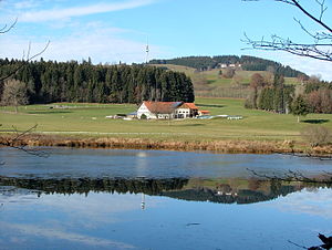
View from the east to the Blender with the Wiggensbacher hamlet of Notzen and OA 15 (front) and the Blender telecommunications tower |
||
| height | 1072.3 m above sea level NHN | |
| location | District of Oberallgäu , Swabia , Bavaria ( Germany ) | |
| Mountains | Kürnach Forest | |
| Coordinates | 47 ° 43 '45 " N , 10 ° 13' 30" E | |
|
|
||
| particularities | Telecommunication tower blender | |
|
View over the Herrenwieser Weiher and past the Herrenwies farmhouse northwest to the Blender |
||

The Blender near Buchenberg and Wiggensbach in the Swabian district of Oberallgäu in Bavaria is 1072.3 m above sea level. NHN high mountain in the Kürnach forest .
geography
location
The Blender rises in the Kürnacher Wald, a part of the Adelegg landscape , in the area of the communities Buchenberg and Wiggensbach . It is located 3.8 km north-northwest of the core of the first-mentioned and 1.8 km south-southwest of that of the last-mentioned municipality. On the northern flank of the mountain are the hamlet Holdenried and Hino , northeast are Wendelin and Unterried and east Notzen with lying beyond Ermengerst , all belonging to Wiggensbach, located on the southern slope with some east of the summit detached houses Eschach mountain , at its At the south foot lies Masers and at the south west foot Wegscheidel , all of which belong to Buchenberg. The Herrenwieser Weiher lies about 2.5 km to the south-east (as the crow flies ) . The Rohrach rises north-north-west of the hilltop , the Kürnach to the south-west , and the Kollerbach flows past to the south-east .
The Blender is not the highest elevation in the vicinity, this is the Dürre Bichl (also called Dürrer Bühl ; approx. 1077 m ) located about 900 m west-northwest , but the most striking. The highest point in the Kürnach Forest is the Ursersberg (approx. 1129 m ), which is around 3.5 km (as the crow flies) southwest of the Blender.
Natural allocation
The Blender belongs within the foothills of the Alps in the natural spatial main unit group Nagelfluhhöhen and Senken between Lake Constance and Isar (No. 02) and in the main unit Adelegg (023) to the subunit Hohe (Südliche) Adelegg (023.0) and within its north and northeast flanks to the northeast Adelegg (023.1). Its landscape falls to the north, east and south into the natural area of the moraine hill country of Buchenberg-Wiggensbach (035.02), which belongs to the Iller foothills, which belongs to the sub-unit western sub-unit in the main unit group Subalpines Jungmoränenland (03) and in the main unit Iller-Jungmoränenland (035) Iller-Jungmoränenland (035.0) counts.
Telecommunication tower blender
On the Rauhenstein , the southwestern foothills of the Blender, the 115 m high telecommunications tower Blender is located at an altitude of 1057 m in the municipality of Wiggensbach . It was built by the Deutsche Bundespost in 1982/83 as a replacement for a lower steel lattice mast as a type tower (FMT 15) and put into operation in October 1984. In addition to directional and mobile radio , the tower is used to broadcast the Kempten regional radio station RSA-Radio on the VHF frequency 97.6 MHz.
Transport, hiking and sports
The district road OA 15 leads past the Blender in the northeast between Wiggensbach and Ermengerst and in the east of Ermengerst in the direction of Ahegg . State road 2376 , which runs south of the mountain to the hamlet of Wegscheidel , branches off from this at the Herrenwies farmhouse .
Several hiking trails lead over the Blender , which can be mastered both on foot and by bike; an ascent is also possible for children. It takes about one and a half hours from the center of Wiggensbach to the summit. On the Wiggensbach side, a fitness trail has also been set up at the foot of the mountain . The most difficult ascent and summit of the pre-alpine marathon also runs on the mountain .
Possibility of viewing
When the visibility is good , the view from the Blender falls to the Alps , including the Grünten in the Allgäu Alps, 20.5 km south-southeast, and the Zugspitze in the Wettersteingebirge, about 67 km southeast . On the other hand, the mountain with the tower offers a distinctive orientation point for the surrounding area. With its telecommunications tower, it can be seen from afar from all directions.
gallery
View from the Blender southeast to the Alps (with Zugspitze ); Kempten in the Allgäu is covered by the early morning fog
Hamlet Masers (in front) and Eschachberg (above it) with Blender and telecommunications tower Blender
View from the Blender southeast to the Allgäu Alps with Eschachberg and Masers in the foreground
Blender from the south of Buchenberg from
Social psychiatric facility
On the south-eastern slope of the Blender in the Buchenberg hamlet of Eschachberg stands the Haus am Blender , a “ social psychiatric facility for chronically ill adults”. Filmmaker Susann Reck , who spent a large part of her childhood in the mountain region, released the documentary entitled Blender (2015).


