Wetterstein Mountains
| Wetterstein Mountains | |
|---|---|
|
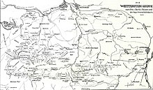
Overview map of the Wetterstein Mountains |
|
|
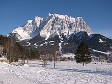
Wetterstein Mountains and Mieming Range (left) from the northeast |
|
| Highest peak | Zugspitze ( 2962 m above sea level ) |
| location | Bavaria , Tyrol |
| part of |
Northern Limestone Alps , AVE 4 : Wetterstein Mountains and Mieming Chain SOIUSA : 21.III.B
|
| Coordinates | 47 ° 25 ' N , 11 ° 8' E |


The Wetterstein Mountains , also known as Wetterstein for short , are a mountain group of the Northern Limestone Alps in the Eastern Alps . It is a relatively compact mountain range between Garmisch-Partenkirchen , Mittenwald , Seefeld in Tirol and Ehrwald . Germany with the Free State of Bavaria and Austria with the State of Tyrol have a share . The main summit of the Wetterstein, the Zugspitze , is also the highest mountain in Germany.
The Wetterstein Mountains are an ideal area for mountaineers and climbers . Mountain hikers sometimes have to cope with large differences in altitude. The proximity of the mountains to the southern German metropolitan areas, the scenic attractiveness and the good accessibility with cable cars mean that the mountains are heavily frequented by tourists at some times. However, there are also areas in the Wetterstein Mountains that are seldom used by humans.
Neighboring mountain groups

The Wetterstein Mountains border on the following other mountain groups in the Alps:
- Ammergau Alps (in the west and north)
- Bavarian Prealps (in the northeast)
- Karwendel (in the east)
- Mieminger chain (in the south)
According to AVE , the Alpine Club division of the Eastern Alps , the Wetterstein Mountains and the Mieminger Chain are a connected mountain group. Then the Inn forms the southern border and the Ötztal and Stubai Alps join.
Boundary
In the west and north, the Loisach forms the border from the Ehrwald Basin to Garmisch-Partenkirchen . In the northeast, the border runs from Garmisch-Partenkirchen to Mittenwald along the Kankerbach , the Kranzbach and the Isar . In the east, the Isar forms the border from Mittenwald to Scharnitz . South of Scharnitz, the border continues along the Drahnbach up to Seestadeln. In the south, the border from Ehrwald runs along the Gaisbach and over the Ehrwalder Alm to the Gaistal ( Leutascher Ache ) and further over Leutasch -Oberweidach and north of the Simmelberg past the Drahnbach.
The saddle between the Kankerbach and the Kranzbach (watershed Loisach - Isar) connects the Wetterstein with the Bavarian Prealps. The saddle at Ehrwalder Alm creates the connection between Wetterstein and the Mieminger chain.
Subgroups
The Alpine Club Guide divides the Wetterstein Mountains into the following subgroups:
- Zugspitze and Plattumrahmung (the peaks around the Zugspitzplatt )
- Riffelwandkamm (the northernmost of the side ridges emanating from the Zugspitze)
- Waxensteinkamm (the continuation of the Riffelwandkamm)
- Blassenkamm (the middle of the ridge of the Wetterstein, from the Zugspitze to the Alpspitze and beyond)
- Wettersteinkamm (the southernmost and longest of the three ridges of the Wetterstein, from Gatterl in the west to Mittenwald in the east)
- Arnspitzgruppe (a single mountain range near Scharnitz)
According to SOIUSA , the Wetterstein Mountains are divided into two groups and eight subgroups:
- Zugspitz Group ( 4 )
- Zugspitz massif ( 4.a )
- Corrugated wall massive ( 4.b )
- Waxenstein massif ( 4.c )
- Blassen Massif ( 4.d )
- Wetterstein main ridge ( 5 )
- Hochwanner massif ( 5.a )
- Three-gate solid ( 5.b )
- Wettersteinwand massif ( 5.c )
- Wamberg massif ( 5.d )
summit
The 10 highest peaks of the Wetterstein:
| 1. | Zugspitze | 2962 m | 6th | Hochwanner | 2744 m | |
| 2. | Schneeernerkopf | 2875 m | 7th | Middle Höllentalspitze | 2743 m | |
| 3. | Zugspitzeck | 2820 m | 8th. | Inner Höllentalspitze | 2741 m | |
| 4th | Medium weather peak | 2750 m | 9. | Outer Höllentalspitze | 2720 m | |
| 5. | Northern Weathertop | 2746 m | 10. | High pale | 2706 m |
In Wetterstein there are over 150 named and with spot elevation provided Summit. The better known include (in order of height):
|
|
The Zugspitze is climbed very frequently on various routes, and the Alpspitze is also a popular summit destination thanks to several climbing systems . The Jubiläumsgrat as a high alpine guide connects these two peaks. The climbing along the Blassenkamm over the summits of Innerer, Mittlerer and Äußerer Höllentalspitze has places up to the lower third level of difficulty (III- according to UIAA scale).
The area around the Oberreintalhütte and the south side of the Schüsselkarspitze and the Scharnitzspitze are known for alpine climbing routes of all levels of difficulty in firm, platy limestone. The south side above the Gaistal is much quieter than the north side.
The mountains north of Leutasch are very interesting for climbers, especially the Oberreintal-Schrofen, the Scharnitzspitze and the Schüsselkarspitze. There are large numbers of alpine climbing routes on the south faces of these three border mountains. In the last few years, Heinz Zak started to renovate some alpine classics. This fact attracts more and more climbers to this area.
natural reserve
fauna
The combination of alpine pastures and rugged rocky regions is not only unique in the German Alpine region, but also offers a habitat for some animal species, such as chamois, Alpine marmots, Alpine choughs, Alpine salamanders, adder, golden eagles and many species of marten.
tourism
Huts
The German Alpine Club maintains six alpine club huts with overnight accommodation in the Wetterstein Mountains: the Münchner Haus ( 2959 m ), the Meilerhütte ( 2366 m ), the Knorrhütte ( 2052 m ), the Kreuzeckhaus (also: Adolf-Zoeppritz-Haus, 1652 m ), the Höllentalangerhütte ( 1379 m ) and the Reintalangerhütte ( 1366 m ). There is no overnight accommodation in the Höllental entrance hut ( 1045 m ), which is also operated by the Alpine Association, at the northern entrance to the Höllental Gorge . In addition, the privately managed Schachenhaus ( 1866 m ) and the Wiener Neustädter Hut ( 2209 m , maintained by the Austrian Tourist Club ) offer food, shelter and accommodation for mountaineers and hikers. The Munich section of the German Alpine Club has leased the Waxensteinhütte (also Alpl- or Aiplehütte) since 1920 and operates it as self-catering accommodation. The Oberreintalhütte is located in the Oberreintalkar and is the meeting point for the Wetterstein climbers (self-catering hut with drinks sold by the hut owner). In winter, the Stuibenhütte is open as a serviced self- catering hut for ski tourers and snowshoe hikers . There are also several privately owned huts in the Wetterstein Mountains. Of these, the Kreuzjochhaus stands out with its idyllic location, as you have one of the most beautiful panoramas in the Bavarian Alps in front of you in summer and you are in the middle of the Garmisch-Partenkirchen ski area in winter .
Long-distance and long-distance hiking trails
The Via Alpina , a cross-border long-distance hiking trail with five partial trails through the entire Alps, also runs through the Wetterstein. The Red Trail of Via Alpina runs through the Wetterstein in three stages as follows:
- Stage R44 runs from Scharnitz to the Meilerhütte via Leutasch Gasse
- Stage R45 runs from the Meilerhütte to the Reintalangerhütte via the Schachenhaus
- Stage R46 runs from the Reintalangerhütte to the Coburger Hütte (the second part of this stage is in the Mieminger chain)
The Northern Alpine Trail (Austrian long-distance hiking trail 01) runs with its section 15 in two variants through the Wetterstein.
From Scharnitz via the Hohe Sattel to Leutasch-Ahrn, both variants follow the same route. In Ahrn, the long-distance hiking trail forks into a high-alpine and an easier variant. The high-alpine variant leads over the Meiler Hütte into the Reintal and on to the Zugspitze summit. From there you descend to Ehrwald. The easier variant leads through the Leutascher Achental and over the Ehrwalder Alm to Ehrwald.
Via ferratas
There are the following via ferratas in the Wetterstein:
- Get on the Riffelscharte
- Via ferrata through the Höllental to the Zugspitze
- Via ferrata over the Wiener Neustädter Hütte to the Zugspitze
- Get on the Schneeernerkopf
- Alpspitz Ferrata
- Brunntalgratsteig from the Knorrhütte to the Jubiläumsgrat
- Via ferrata to the Dreitorspitze ( Hermann-von-Barth -Weg)
- Schöngang at the Alpspitze
- Nordwandsteig on the Alpspitze
- Mauerläufersteig on the Bernadeinkopf
- Mathaisenkar-Ferrata from the Höllentalangerhütte through the Mathaisenkar to the Alpspitze
Mountain railways
Several large mountain railways open up the summit regions and high-altitude ski areas: the Bayerische Zugspitzbahn ( rack railway in meter gauge from Garmisch to Zugspitzplatt), the Eibseeseilbahn (aerial cableway from Eibsee to Zugspitzplatt), the Tyrolean Zugspitzbahn (aerial cableway from Ehrwald to Zugspitzplatt) and the Ehrwalder Almbahn.
Attractions
If you don't want to go on a climbing tour or a multi-day summit tour, you can hike through the Partnach Gorge , the Leutasch Gorge or the gorge to the Höllental as a day tour .
Wetterstein tunnel
The project of a railway tunnel connection between the Tyrolean Telfs and the Bavarian Garmisch-Partenkirchen has been discussed for a long time . The tunnel would have a total length of 22 kilometers and would allow an edge time of 90 minutes between Munich main station and Innsbruck main station in long-distance traffic . In 2013, the project was estimated at 2.2 billion euros in construction costs. A tunnel through the Wetterstein would accelerate rail traffic between Munich and Landeck or Vorarlberg by one hour and thus relieve both the Munich - Rosenheim - Innsbruck route and the Munich - Lindau route. With the Garmisch bypass and the relocation of the south portal east of Telfs-Sagl, the tunnel would be almost 25 kilometers long.
literature
- Fritz Schmitt: Wetterstein. Valleys, ridges and walls. Alpine monograph. Rother Verlag, Munich 1979, ISBN 3-7633-7134-6
Web links
Individual evidence
- ↑ Sergio Marazzi: La “Suddivisione orografica internazionale unificata del Sistema Alpino” (SOIUSA) (pdf, ital .; 1.6 MB)
- ↑ Thomas Kantke, Stefan Baumgartner: Federal Transport Infrastructure Plan 2015 - additional proposed measures for the Free State of Bavaria , Munich 2013.


