
Öfelekopf
| Öfelekopf | ||
|---|---|---|
 Öfelekopf from the south |
||
| height | 2478 m above sea level A. | |
| location | Tyrol , Austria | |
| Mountains | Wetterstein Mountains | |
| Dominance | 1.5 km → Leutascher Dreitorspitze | |
| Notch height | 267 m ↓ Söllerpass | |
| Coordinates | 47 ° 24 '15 " N , 11 ° 8' 57" E | |
|
||
| rock | Wetterstein lime | |
| Age of the rock | Ladinium - Carnium | |

The Öfelekopf is a 2478 m above sea level. A. high peak in the eastern part of the Wetterstein Mountains . The west summit bears the summit cross, but the east summit is 9 m higher than the west summit. The west summit requires climbing in difficulty level II, the east summit III +.
Climbing
- To the west summit
- West ridge (from the Meilerhütte ), II, 2h
- From Leutascher Platt II, 2h
- over the Ostgipfel III, ¾h
- South ridge (Preuss ridge) IV-, 3h
- Southwest edge V-, 4h, brittle
- Southwest Pillar VI, 7-9h
- Southwest wall V +, 4½h
- South pillar VI, 6h
First ascent in 1871 by Hermann von Barth . Wastl Mariner was the first to climb (1935) the south-west pillar at Öfelekopf in the Wetterstein Mountains together with Hans Frenademetz and Hias Rebitsch .
- Valley locations: Leutasch
- Support points: Meilerhütte (DAV section Garmisch-Partenkirchen )
Web links
Commons : Öfelekopf - Collection of images, videos and audio files
Individual evidence
- Helmut Pfanzelt: Alpine Club Guide Wetterstein and Mieminger Chain. Bergverlag Rother , 1971, ISBN 3-7633-1113-0 : margin number 551ff.
- ^ Geological map of the Republic of Austria 1: 50,000, published by the Federal Geological Institute , Vienna 1992, sheet 117 Zirl

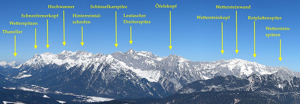
View from the Central Alps over the Inn Valley to the Wetterstein main ridge
