
Kankerbach (Partnach)
| Kankerbach | ||
 Catchment area of the Kankerbach |
||
| Data | ||
| Water code | DE : 16244 | |
| location | District of Garmisch-Partenkirchen , Upper Bavaria , Bavaria , Germany | |
| River system | Danube | |
| Drain over | Partnach → Loisach → Isar → Danube → Black Sea | |
| origin | at Schloss Kranzbach 47 ° 28 ′ 38 ″ N , 11 ° 12 ′ 51 ″ E |
|
| Source height | 1079 m above sea level NN | |
| muzzle | in the Partnach in Garmisch-Partenkirchen Coordinates: 47 ° 29 '45 " N , 11 ° 5' 53" E 47 ° 29 '45 " N , 11 ° 5' 53" E |
|
| Mouth height | 700 m | |
| Height difference | 379 m | |
| Bottom slope | 34 ‰ | |
| length | 11 km | |
| Communities | Krün , Garmisch-Partenkirchen | |
 Kankerbach near Kaltenbrunn |
||
The Kankerbach (also Kanker , in the upper reaches of Köchelgraben ) is an 11 km long right tributary of the Partnach . The stream rises as Köchelgraben near the Kranzbach Castle . The name Kankerbach is given to the water after the confluence of the Aschenmoosbach. The Kankerbach then flows from east to west in a valley between the Wamberg saddle in the south and the Estergebirge in the north and takes on numerous other small streams and ditches (Gütlegraben, Altenbach, Ellergraben, Wamberger Graben). It then bends to the northwest and flows through parts of Partenkirchen, where the Faukenbach flows into it. The Kankerbach flows into the Partnach within the local area of Partenkirchen.
During the Whitsun floods in 1999 , the Kankerbach flooded large parts of Partenkirchen, as the narrow, partially overbuilt channel could no longer absorb the water masses. The damage amounted to around 25 million euros and there was one fatality. This event subsequently led to flood protection measures. The restraint area near the Garmisch-Partenkirchen Clinic was expanded and a mostly underground bridge to the Partnach was created from there. In addition, the channel in the local area of Partenkirchen was expanded and redesigned.

View from Garmisch to the east into the Kankertal. On the right the Wamberg saddle, on the right in the background the Soiernspitze
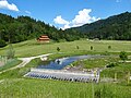
Flood protection system near the Garmisch-Partenkirchen Clinic

The confluence of the Kanker bridge in the Partnach. On the left in the background the Olympic ski jumps, on the right on the horizon the Dreitorspitze
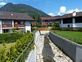
The newly created channel of the Kankerbach in Partenkirchen. In the background the Wank
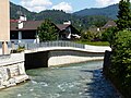
The confluence of the Kankerbach (under the bridge) with the Partnach


Individual evidence
- ↑ Water Management Office Weilheim: Improvement of the flood protection on the Kanker and Partnach ( Memento of the original from May 17, 2013 in the Internet Archive ) Info: The archive link was inserted automatically and has not yet been checked. Please check the original and archive link according to the instructions and then remove this notice. . Retrieved June 15, 2014.
- ↑ The Kanker Bypass: Garmisch-Partenkirchen is armed for the flood of the century Merkur-Online of June 12, 2008, accessed on June 15, 2014.