
Isar
.png)

The Isar is a river in Tyrol ( Austria ) and Bavaria ( Germany ) that is not navigable for watercraft larger than raft-size and flows into the Danube from the right after a 292 km long run south of Deggendorf .
It rises in the Alps in the Tyrolean part of the Karwendel in the Hinterautal , after about 22 km below Scharnitz it crosses the state border to Bavaria, where it first flows in the Alps through Mittenwald and in the so-called Isarwinkel through Lenggries and Gaißach . It reaches the Alpine foothills at the beginning of the middle course near Bad Tölz , followed by the cities of Geretsried , Munich , Freising and Moosburg . The lower course flows through Landshut , Dingolfing , Landau an der Isar and Plattling .
The Isar flows into the Danube five kilometers south of Deggendorf. The earlier form as a typical mountain and pre-Alpine river with a wide, constantly shifting river bed , extensive gravel banks and branched river arms it only shows in individual areas of the upper reaches. After the Danube, the Inn and the Main , the Isar is the fourth largest river in this state with its catchment area of 8964.57 km², which is largely located in Bavaria.
The most important tributary is the Amper , which flows into Moosburg , followed by the Loisach, which flows into Wolfratshausen .
etymology
According to the current state of research, the name of the river can be traced back to the hypothetical Indo-European root * es or * is with the meaning "(flowing) water", which in today's languages has narrowed to the solid state of the water ("ice"). The river was first mentioned in 763 as "Isura" in the tradition book of the Hochstift Freising .
A number of other river names are derived from this root:
- Jizera or Iser ( Czech Republic ), Izera ( Poland )
- Isère , ( France )
- Isère, Oise (then Isara ) ( France )
- Isel ( Austria )
- IJssel ( Netherlands )
- Yser ( French ), IJzer ( Dutch ) ( Belgium )
- Eisack (Italian: Isarco) ( South Tyrol , Italy )
- Isen ( Bavaria , Germany )
The name Ister for the lower section of the Danube probably has the same origin. The "Eisach" ("watercourse") containing the same root as the name of several mountain streams in the Alpine region does not necessarily have to refer to "ice-cold" water.
The interpretation of Hans Bahlows , is that the word Isar of it, as or os be inferred and was thus to be interpreted as "swamp water" is highly controversial among experts, because it is in the name of carriers to watercourses.
In any case, the interpretation that the name Isar is composed of the Celtic words ys (fast, tearing) and ura (water, river) is considered out of date . According to another interpretation, ys should stand for high and low at the same time and thus designate the vertical.
geography
The Isar drains a large part of the Bavarian Alps and parts of the Karwendel northwards to the Danube and ultimately to the Black Sea . Overall, the catchment area does not quite cover 9,000 km². Since the precipitation in winter mostly falls as snow, especially in the Alps, the Isar carries a lot of water during the snowmelt in early summer. With an average discharge of around 176 m³ / s, it is comparable to medium-sized German rivers such as the Main (211 m³ / s).
Course of the Ur-Isar
The Isar is a meltwater outflow from the Isar-Loisach glacier during the Würme Ice Age. A cold-age flow path of this "Ur-Isar" ran from Gaißach south of Bad Tölz to the northeast in the direction of Holzkirchen . At first it followed an approximate line from Holzkirchen - Helfendorf - Assling to Wasserburg , where it ended in the "Ur-Inn". Later it turned north and followed roughly the line Holzkirchen - Egmating - Markt Schwaben - Erding and met the Loisach near Moosburg north of Munich. The exact course of the Ur-Isar is uncertain.
15,000 years ago there was a breakthrough in Bad Tölz through a molasse bar, which gave the Isar its current direction of flow to the north. At the end of the Würme Ice Age it flowed into the Wolfratshausen lake , which it silted up.
Source rivers


Information board about the origin of the Isar
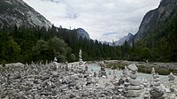
Steinmandl on the Isar in the Hinterautal

The Isar in the Hinterautal a few kilometers before Scharnitz


The sources or streams officially designated as the source of the Isar are located in the Hinterautal between the two middle Karwendel chains , the Gleirsch-Halltal chain in the south and the Hinterautal-Vomper chain in the north, at 1160 m above sea level. A. The Lafatscher Bach rises as the longest source brook of the Isar about five kilometers southeast near the Hallerangerhaus in the municipality of Absam . The source of the Lafatscher Bach is therefore also called the Isar spring. The length of the Isar of 292.26 kilometers refers to this source.
Course and tributaries
The Isar flows west within the Karwendel. A few kilometers before it reaches the town of Scharnitz on the western edge of the mountains, the Gleirschbach and Karwendelbach flow in and the river turns north and passes the valley of the Scharnitz Klause and the Austrian-German border . At the southern outskirts of Mittenwald, the Leutascher Ache flows from the west on the south side of the Wetterstein Mountains , which up to this point is almost as long as the course of the Isar. Between Mittenwald and Krün , the Isar is dammed for the first time at the Krün weir, most of its water is branched off here and fed through the Isar overpass to the Obernach power plant on the Walchensee . At Wallgau , the course of the river turns east into the Isarwinkel, where the Dürrach and the Walchen , which, as the Ache, are a natural outflow of the Achensee and form the eastern boundary of the Karwendel Mountains, flow together as tributaries from the Karwendel . Dürrach and Walchen now reach the river in the Sylvenstein reservoir , which was built between 1955 and 1959 for the purpose of flood protection and energy generation . The water of the Rissbach coming from the Riss valley is dammed at the Oswaldhütte ( 844 m above sea level ) on the road Vorderriß (Bavaria) - Hinterriß (Tyrol) and discharged into the almost seven kilometer long Rissbach tunnel, in which the water goes to the power station Niedernach is fed.
From the Sylvenstein reservoir, the Isar flows north through the Bavarian Prealps and from Bad Tölz through the worm-age moraine landscape of the Alpine foothills to the Munich gravel plain . Between Sylvensteinsee and Lenggries the Jachen reach the Isar from the left and the Große Gaißach from the right in Gaißach . The runoff of the Walchensee, whose water today reaches almost 100% through the Walchensee power plant into the Kochelsee , is thus the Loisach. This flows from Lermoos in Tyrol along the north side of the Wetterstein Mountains to Garmisch , then through the Kochelsee and finally flows into the Isar at Wolfratshausen. In Munich, water is again diverted from the Isar into the Middle Isar Canal . It leads to the right of the Isar through the Erdinger Moos and feeds seven hydropower plants before it flows back into the Isar behind Moosburg. At Freising, the Isar reaches the northern edge of the gravel plain and flows east in front of it. Here you feed the villages with water from the Erdinger Moos. The Sempt flows from the right near the northeast stretch of the plain before Moosburg . Behind Moosburg, the largest tributary, the Amper, flows from the left, which rises as the Ammer near the Austrian border southwest of Linderhof Castle and only bears the name Amper after flowing through the Ammersee . From Moosburg the Isar flows in a glacial valley through the Lower Bavarian hill country, which was shaped by the Tertiary period , north-east to the Danube valley.
After a total of 292.26 kilometers of river, of which 270.36 km in Germany, the Isar, which has a mean bed gradient of 2.9 ‰, flows into the municipality southeast of Deggendorf at 312 m above sea level, i.e. about 848 meters below its source Moss in the Danube.


Islands
Most of the small islands and gravel banks of the Isar are repeatedly changed in size and shape by the annual floods . Some islands in the immediate vicinity of larger cities were built in the 19th century and thus secured against erosion: the Museum Island and the Prater Island in Munich as well as the Hammer Island , the Mühleninsel and the Mitterwöhr in Landshut.
history
The Isar was probably used as a trade route in prehistoric times to transport goods from the Alps and from Italy to the Danube with the help of rafts . An already existing trade route from the Inn Valley via the Seefelder Sattel into the northern foothills of the Alps was expanded by the Romans from 195 AD to the Via Raetia . The Mittenwald market on the Isar was able to develop from a Roman post into an important trading center for merchandise in Werdenfelser Land .
Bridges over the Isar have only been documented since the Middle Ages. The cities of Munich and Landshut were founded in the Middle Ages in connection with the construction of bridges over the Isar, and it was always about managing trade routes and thus gaining power and economic influence. The further expansion of the cities created a constant demand for wood and lime, which led to an upswing in rafting (especially in the Oberland ). Since the 17th century, goods such as tropical fruits, spices, cotton and silk have been transported from the Venetian market in Mittenwald across the Isar to Vienna and Budapest . At the height of rafting in the 19th century, over 8,000 rafts landed in Munich each year.

Since the Middle Ages , water mills , among other things, have been driven by the hydropower of the Isar, which required a constant water level. That is why in Munich and Lower Bavaria ( Klötzlmühlbach and Längenmühlbach ) water was diverted from the river into smaller mill channels . The Munich city brooks also served as canals to supply the population with process water and fed the trenches in front of the medieval city walls. During the annual floods there were repeated floods and accidents in the neighboring cities and communities. In 1813, for example, a previous building of today's Ludwigsbrücke collapsed in Munich, killing over 100 onlookers standing on the bridge; During the flood of 1899 , the Luitpold Bridge and the Max Joseph Bridge also collapsed in Munich . Since 1806, in Lower Bavaria since around 1900, the banks began to be fortified and the river channeled so that it dug deeper into its bed and then stepped over the bank less often.
Further extensive, regulatory measures have been carried out since the 1920s in order to generate electrical energy from hydropower. With the construction of the Walchensee power plant in 1924, massive encroachments were made in the natural upper reaches of the Isar. Since then, the Krün weir has diverted almost all of the Isar water to the Walchensee. In 1951, the Isar also lost almost all of the water from the Rißbach , which has since been passed on to the Walchensee. The upper reaches of the Isar lost further water with the construction of the Achensee power plant in 1927 - the Achensee no longer drains primarily via the Seeache / Walchen and Isar, but to the south via the Inn. The Achensee power plant has been supplied with water from the Dürrach since the 1950s , which meant further water loss from the Isar. The Isar was therefore more and more a river corpse in the upper part, so that an urgent improvement in the situation was required. That is why the then highly controversial construction of the Sylvenstein reservoir (completed in 1959) was finally started in order to achieve a more constant water level in the Isar. The additionally guaranteed flood protection, however, was only a secondary goal. In Landshut, the Landshut flood basin was completed in 1955 , which absorbs part of the water during floods.
Further hydropower plants with barrages were built up into the 1980s, around 1984 the Landau hydropower plant . Only recently have attempts been made to restore the Isar to its original wild river character, at least in some areas, through various measures. For example, through the Isar plan in Munich and the renaturation of the banks of the Isar near Landau and, from 2016, near Dingolfing.
On the lower reaches of the Isar between Moosburg and Plattling, gold was panned from the river deposits , especially in the 16th and 17th centuries . Place names such as Golding ( Gottfrieding community ) and Goldern ( Niederaichbach community ) are evidence of this . However, the quantities of precious metal obtained in this way were small and not of great economic importance. The gold was mainly used to mint river gold ducats . They can be recognized by the inscription EX AURO ISARE (= from the gold of the Isar).
Modern canoeing was founded on the Isar . In 1905 Alfred Heurich sailed the Isar between Bad Tölz and Munich for the first time in his self-made folding boat in the form of a kayak. This sport quickly became popular across Europe.
Nature and environmental protection

Wild river landscape of the Isar between Wallgau and Vorderriß

The Isar near Lenggries

The Isar near Ascholding
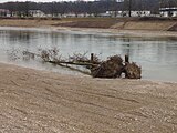
During the renaturation of the Isar, predatory trees are also built in, as here at Dingolfing


The water of the Isar has been used to generate electrical energy since the 1920s, with far-reaching consequences not only for the native flora and fauna, but also for humans. In order to supply the 28 power plants with the necessary hydropower, the river water is diverted, canalized and dammed several times. For example, north of Mittenwald, from 1923 all the water from the Isar was fed to the Walchensee for the operation of the Walchensee power station. Only since 1990 has a remaining proportion of four cubic meters per second been allowed to flow into the natural river bed, so that the Isar no longer falls dry in this area. The construction of the Sylvensteinsee for flood protection and numerous regulatory measures that had been carried out since the early 19th century, especially in the urban area, also permanently changed the character of the wild river. In the mid-1980s, people rethought and wanted to better balance flood protection, ecology and the recreational value of the river for the residents. The Isar Plan was implemented from 1995 to 2011 as part of an open plan with the intensive involvement of associations, political bodies and citizens.
Since the completion of the Sylvensteinsee, the Isar has only rarely overflowed its banks downstream of the reservoir. Special exceptions were the major floods in 1999, 2002, 2005 and 2013. At that time, even the deeply cut river bed could no longer contain the amount of water, which is why the riparian forests in many places between Munich and Moosburg were flooded and enriched with sediments for the first time in decades . The deepening of the river bed is a result of the many reservoirs and the lateral bank reinforcements. The reservoirs hold back the natural debris from the upper course , the barriers prevent the Isar from eroding its banks, which is why this debris source has also dried up. The erosion in the river bed increases and the Isar cuts deeper and deeper into the landscape. In some areas, for example at the level of Geretsried, the bottom has already reached the softer upper freshwater molasse lying under the gravel deposits (“bottom penetration”). There is now a threat of a rapid deepening, with consequences not only for the course of the Isar, because with the river level the groundwater level in the area will continue to drop.
In recent times, attempts have been made to restore the Isar's originality through various measures to restore the natural environment. For example, since May 2000, an eight-kilometer section of the river landscape in the southern urban area of Munich has been renatured . For this purpose, the river bed was widened, the banks were flattened and gravel islands and near-natural bed ramps were created. The existing dikes were also raised, widened and reinforced by installing a cut-off wall. When the concession for the Mühltal hydropower plant was extended , the decision of June 28, 1995 issued conditions that are intended to promote the independent regeneration of the natural watercourse functions. For example, a minimum water discharge of 15 m³ / s - after 5 m³ / s previously - was required for the diversion section , and bank barriers had to be removed over a length of more than seven kilometers. Because of the removal of the barriers, the floods in 1999, 2002 and 2005 resulted in the Isar now significantly widening its river bed over several hundred meters and again showing elements of an alpine river landscape.
Despite better protection against floods, the river landscape of the Isar is now closer to nature again. This important local recreation area in the greater Munich area has become more attractive for visitors. By upgrading various sewage treatment plants along the Isar, the water quality has also increased. The river water currently belongs to water quality class II, so it is considered to be moderately polluted. However, the number of germs is still high. In 1998, together with a number of other cities and municipalities along the Isar, the city of Munich set itself the goal of improving the water quality to such an extent that the Isar can officially be opened for swimming. The goal has so far only been partially achieved: on the Isar upper course, sewage treatment plants were put into operation, which drastically reduce the number of germs by treating the wastewater with ultraviolet light , so that the city of Munich was able to remove the warning signs in 2005, which warned of the risk of infection with germs Baden warned. This means that the EC directive for bathing water can usually be complied with during the operating time of the UV disinfection systems between April 15 and September 30. However, the Isar cannot be designated as bathing water in the urban area, as the water quality can deteriorate too much due to the input from precipitation, especially during heavy rain.

The color of the Isar is green. This can be attributed to the minerals that the river carries with it. Because the proportion of very fine sediments is very low, like in snow or glacier ice , the sunlight is filtered and reflected , which makes the Isar appear bluish near the source. With an increase in dissolved minerals , which in the Isar are often limestone , the color from the Alps to the mouth turns green.
_P1060858a.jpg)
A number of nature , landscape and, for individual gravel banks, bird sanctuaries have been designated along the Isar , for example the nature reserve “ Vogelfreistätte Mittlere Isarstauseen ” northeast of Moosburg. This nature reserve is an important resting place for migrating water birds. Over 260 different bird species have been identified so far, including endangered species such as the common tern and the bluethroat . The Isarauen nature reserve between Hangenham and Moosburg is located northeast of Freising in the mouth of the Moosach and some streams. The "Untere Isar" landscape protection area and the "Isar estuary" nature reserve encompass the floodplain landscape in the Isar estuary .

The European protected area "Upper Isar Valley" is located along a hundred kilometers long section of the Isar river between the state border near Scharnitz in the Karwendel Mountains and Munich. This fauna-flora-habitat area (FFH area) is one of the largest in Bavaria with around 4,700 hectares.
In order to preserve the beauty of the Isar Valley, Gabriel von Seidl founded the Isar Valley Association as early as 1902 . In order to achieve this goal, the first Munich citizens' initiative bought over 90 hectares of land and today looks after a total of 330 kilometers of hiking and cycling trails.
The concentration of microplastics increases significantly along the course of the water. In a study published in 2018 by the University of Bayreuth , it was shown that the plastic concentration increases from 8.3 particles / m 3 near Baierbrunn to 87.9 particles / m 3 near Moosburg .
The fish in the Isar near Moosburg can be contaminated with malachite green . In 2019, a total of 336 micrograms per kilo was found in two rainbow trout .
fauna and Flora

The existence of fauna and flora is directly related to the design of the river landscape, which man has had a strong influence on since the 19th century. The flow rate was greatly reduced by damming at numerous weirs , which also led to an increase in the water temperature. Fish species that require oxygen-rich and cooler water as a habitat have been displaced by species from the still water area. Due to the reduced flow speed, the gravel banks are only rarely shifted so that they overgrow. Bird species that need open gravel areas as breeding grounds can no longer find a habitat here.

Through various measures such as the designation of nature reserves, the establishment of improved fish passes at weirs or increasing the amount of residual water, new framework conditions are created to improve the living conditions for many animal species and plants, some of which are rare. However, recent studies on the Ammer (Amper) also show that the decline of the grayling stocks with the rising population of the Goosander related. This endangered duck bird specializes in hunting small fish. This example shows how difficult it is to restore an originally existing ecological balance if it has been permanently disturbed. A comparable connection between the protected cormorants and the fish stocks leads again and again to discussions between fishing clubs and bird conservationists.
In 1976 the beaver was resettled in the Isar delta . From there the animals spread upriver. One example even lived for years in the middle of Munich, right next to the Deutsches Museum . Even after the August flood of 2005 , fresh beaver bite marks could be seen on trees near the Isar.
Some of the typical Isar fish are threatened, such as the huchen or the catfish . In addition to these species occur in the Isar especially trout and perch and Koppe , pike , Nerfling , roach , rudd , Rutte , tench , barbel and pike before. As one of the most important tributaries of the Danube, typical fish species of the Danube can be identified in the lower river area of the Isar, such as the Danube brook lamprey or the Sterlet . The spread of the Danube river lamprey in Germany is, however, controversial among scientists; possibly this is a confusion with the Ukrainian brook lamprey . A total of about 50 native fish species are known. From the source to the mouth, the Isar can be divided into three river regions : the trout region from the source to Lenggries, the grayling region from Lenggries to Moosburg and the barbel region from Moosburg to the mouth.
.jpg)
In addition to common birds such as seagulls , swans and mallards , the Isar also offers a habitat for other, less common species. So let dippers , kingfishers , herons and little ringed plover observed. Become rare, the common tern and the Sandpiper ; they are considered endangered. Their nests are very well camouflaged in the middle of the rubble of the gravel banks and are usually not noticed by those seeking relaxation who enter the gravel areas (designated bird sanctuaries) despite the prohibition. The birds that breed there are severely and lastingly disturbed, especially during the breeding season. The areas marked as a bird sanctuary may not be entered between March 15 and August 10.
Especially in the bank and bank sector, but also on the gravel benches next coming water frogs and lizards also slow worms before. The snakes are represented by the adder as well as the grass snake and smooth snake . In the remaining natural habitats and floodplain endangered amphibian species are mainly on the lower Isar toad , natterjack toad , European tree frog and agile frog before. The moor frog , which is threatened with extinction in Bavaria, is a specialty , of which a small isolated population still occurs in the Isar estuary.
Particularly in the upper, but partly also in the middle section of the river, soil erosion and sedimentation repeatedly create new river beds. These still open gravel areas are first colonized by pioneer plants , which can cope with the difficult conditions there; these include the alpine toadflax , the yellow blooming hawkweed and the German tamarisk . If a gravel bank is not removed again by floods, white silver arum , juniper and finally various types of willow will also settle there after a few years . In a further development, sparse pine forests will gradually emerge .
economy


.jpg)
The Isar is of no importance for inland shipping and thus for the movement of goods, as the river is not navigable for its entire course. In the past, timber and other goods were rafted in considerable quantities on the Isar from Mittenwald via Munich to the Danube. Since the advent of the railroad and motor vehicles, this transport route has hardly been used any more. Parallel to the river which originated Isartalbahn in the southern area and the railway line Munich-Landshut -Plattling in the northern area. The river acquires considerable economic importance through its hydropower, which is used to generate electricity by the Isar-Amper works , among others . The amount of energy generated in this way does not even reach one percent of today's electricity requirements in Bavaria. By cooling the Isar nuclear power plant , however, the Isar indirectly contributes to large-scale energy generation; when both nuclear power plant blocks were still in operation, they covered around 40 percent of Bavaria's electricity needs.
energy
Conventional hydropower plants require a consistently high water level so that energy generation does not come to a standstill in months with little rainfall. This was ensured by the construction of several canals that accompany the course of the Isar and carry most of the river water with them. South of Munich supplies Mühltal channel , the hydropower plant Mühltal with water. In the urban area of Munich there are three power plants ( Isarwerke 1–3 ) built by Stadtwerke München and two power plants by E.ON on the Isar-Werkkanal . The water for the Auer Mühlbach , on which there are three other, smaller hydropower plants, is diverted from the works canal at Marienklause . At the Oberföhring weir on the northern edge of Munich, the Middle Isar Canal branches off towards Erding and only flows back into the river bed after more than 60 kilometers. A power plant on the weir with an output of one megawatt uses the water remaining in the Isar. The power plants along the Isar generate an average of around two billion kilowatt hours of electrical energy a year.
The Sylvensteinsee , which was completed in 1956 as flood protection south of Bad Tölz, is also used to generate energy. The reservoir is able to store a maximum of 124 million cubic meters of water.
The Isar nuclear power plant east of Landshut uses the Isar water for cooling. Due to the cooling of the Isar II reactor, 800 liters of river water evaporate per second in the cooling tower; the striking water vapor plume can often be seen over 100 km from the Bavarian Alps. During the cooling of the Isar I boiling water reactor, which was shut down in 2011 , i. d. Usually no water is lost for the river, as it was warmed up by three degrees Celsius and returned to the river bed. For this reason, the existing cell cooler system was expanded and put into operation in 2009.
tourism


In addition to the Bavarian capital and a number of other cities along the Isar, numerous Isar landscapes and nature reserves are of touristic importance: For example the Isarwinkel or the Pupplinger Au south of Munich. From the source to the mouth, the Isar is accompanied by the Isar cycle path, a relatively easy long-distance cycle path.
For several decades, rafting has also experienced a renaissance in the tourist sector. Every year in the summer months up to 50,000 tourists travel on large rafts weighing up to 20 tons from Wolfratshausen over a distance of 25 kilometers to the raft canal in Munich-Thalkirchen . The weirs of the power plants are overcome by slides. The slide in the Mühltal, south of Schäftlarn Abbey, overcomes 360 meters in height of around 18 meters, making it the longest raft lane in the world. The rafts, which are equipped with a band, tables and benches, the possibility of serving beer and snacks and also an on-board toilet, are dismantled into their individual components upon arrival at the destination, taken to trucks upstream and reassembled there for the next trip.
Driving on the Isar with canoes or similar small and manoeuvrable boats is possible over some of the stretches. However, the currently (2018) increasing number of such river trips poses a problem for flora and fauna. When the water flow is high, standing waves at the Wittelsbacher Bridge in Munich can be used for river surfing or playboating .
In some places along the Isar, people bathe naked, for example north of Wolfratshausen in the area of the Pupplinger Au. In the southern urban area of Munich even nudist areas are officially designated. However, many residents of Munich can be tanned by the sun in the inner city area naked on the banks or on the gravel islands - regardless of official evictions.
The Isar in art, literature and music


The oldest depictions of the Isar were made against a religious background. An altarpiece from 1480 in the Jakobskirche in Lenggries depicts the martyrdom of the apostle James . The unknown artist relocated the beheading, which took place in Jerusalem , to the banks of the Isar.
In the 19th century, artists of the Munich School - such as Wilhelm Scheuchzer , Joseph Wenglein and Wilhelm von Kobell - discovered the Isar as a motif for their pictures. Thanks to the realistic representation of the motifs, her paintings also have a historical value for the documentation of the river environment before its massive construction.
In his homeland novel Der Jäger von Fall , Ludwig Ganghofer set a memorial to the residents of the Isarwinkel for their love of their homeland, thereby making the river landscape of the Isar known nationwide. But the more recent literature also contains stories and facts about the Alpine river. In her book The Green River, Carmen Rohrbach describes her hike from the sources to the river mouth in an impressive manner.
The songwriter and Bavarian blues singer Willy Michl describes the beauty of the Alpine river in his hymn Isarflimmern : "(...) Summer sun on white gravel, next to the emerald green river, when time stands still - then the Isarflicker is in paradise."
In the hymn “Isarmärchen” by the Munich folk singer Bally Prell, there is a declaration of love to the Isar, which characterizes the Bavarian capital. The refrain reads: "... and when the blue sky laughs ... the Isar rustles its ancient little song, beautiful as a fairy tale, you are my Munich".
The Munich composer Quirin Amper Jr. describes the course of the river in his suite for large orchestras , popular groups and narrators The Isar from its source to its confluence with the Danube.
With the book and event series “Die neue Isar”, Ralf Sartori has initiated a comprehensive Isar cultural project within the framework of the “Nymphenspiegel Kulturforum” and changing authors, in the form of a book river that appears annually with another volume on the Isar. This series is flanked by a large number of Isar tours, Isar festivals and art projects on the river.
literature
- City of Dingolfing (ed.): The Isar. Landscape, city, culture. Exhibition catalog, Dingolfing 2005
- Christian Magerl, Detlev Rabe (ed.): The Isar. Wild river in the cultivated landscape. Kiebitz book, Vilsbiburg 1999, ISBN 3-9804048-5-4 .
- Bernhard Setzwein : On the banks of the Isar - A Bavarian river and its history. Koehler and Amelang, Munich / Berlin 1993, ISBN 3-7338-0174-1 .
- Franz X. Bogner. The Isar from the air . Rosenheimer Verlag 2008, Rosenheim, ISBN 978-3-475-53969-5 .
- Walter Binder: Isar river landscape through the ages. Bavarian State Office for the Environment, 2011
- Bavarian State Office for Water Management: Isar river landscape from the state border to Landshut - mission statements, development goals, notes on measures . 2001, ISBN 3-930253-85-2
- Christine Rädlinger : New life for the Isar: from regulation to renaturation of the Isar in Munich , publisher Landeshauptstadt München, building department, Franz Schiermeier Verlag, Munich 2012, ISBN 978-3-9814521-5-0 .
- Christine Rädlinger (with contributions by Karl Hafner, Matthias Junge and Adele Nebel): History of the Isar in Munich , published by Stadtarchiv Munich, Franz Schiermeier Verlag, Munich December 2012, ISBN 978-3-943866-11-7 .
- Christian Pehlemann: Isar aspects. From the source, Upper Isar via Munich to the mouth of the Isar. Steinmeier printing and publishing house. ISBN 978-3-939777-66-3
- Peter Klimesch: Munich Isar Book . 4th expanded edition 2020, ISBN 978-3000583377 .
Web links
- Homepage of the Isartalverein
- Isar stories - virtual museum about the history of the Isar
- The Isar Plan ( Memento from April 7, 2012 in the Internet Archive ) Munich Water Management Office
- Flood news service: Isar water levels
- Isar ( Memento from 7 December 2011 in the Internet Archive ) Landshut water management office
- Contemporary silent film about the expansion of the power station on the Middle Isar near Munich
- Small river, big stories Isar kaleidoscope on BR.de
- Christian Sebald: Only the upper Isar is intact. Süddeutsche Zeitung SZ.de, August 19, 2020, accessed on August 20, 2020 .
Individual evidence
- ↑ Topographic map 1: 25,000
- ↑ a b c d e f Directory of creek and river areas in Bavaria - Isar river area, page 1 of the Bavarian State Office for the Environment, as of 2016 (PDF; 2.5 MB)
- ^ German Hydrological Yearbook Danube Region 2006 Bavarian State Office for the Environment, p. 184, accessed on October 4, 2017, at: bestellen.bayern.de (PDF, German, 24.2 MB).
- ↑ Plattling gauge value increased by the drainage of the remaining catchment area (6.9 l / s.km² to 262.19 km²), determined for the intermediate catchment area of the Pfelling (Danube), Haberkofen (Ödbach), Deggendorf (Kollbach), Wallersdorf (Reissingerbach) gauges , Plattling (Isar), Auerbach (Hengersberger Ohe) and Hofkirchen (Danube)
- ^ Martin Bitschnau , Hannes Obermair : Tiroler Urkundenbuch. II. Department: The documents on the history of the Inn, Eisack and Pustertal valleys. Volume 1: By the year 1140 . Ed .: Tiroler Landesmuseen-Betriebsgesellschaft mbH Universitätsverlag Wagner, Innsbruck 2009, ISBN 978-3-7030-0469-8 , p. 25-27, No. 45 .
- ^ Rolf K. F. Meyer & Hermann Schmidt-Kaler: Walks in the history of the earth. On the trail of the Ice Age south of Munich - eastern part. Pfeil, Munich 1997. p. 31 f.
- ↑ Erwin Schirm: The hydrogeological conditions of the Munich gravel plain east of the Isar. Contribution to the UNESCO hydrological decade. Bavarian State Office for Hydrology. Munich 1968 (diss.).
- ↑ Hermann Jerz : The Wolfratshausener pool. Its glacial structure and deepening. Ice Age and Present 29 (1979): pp. 63-69.
- ↑ Historical Geretsried working group: The emergence of the Alpine foothills .
- ^ Renaturation of the banks of the Isar near Landau. ( Memento from July 6, 2017 in the Internet Archive )
- ↑ The Isar the bed is made new . ( Memento from March 5, 2016 in the Internet Archive ) In: Schaukasten, March 2016, p. 8.
- ^ Paul Arnold, Harald Küthmann, Dirk Steinhilber: Large German coin catalog from 1800 to today , Augsburg 1997: p. 54, Bavaria, no.67, Isar gold ducats from 1830
- ^ Munich gauge on August 12, 2002; Flood news service Bavaria.
- ^ Walter Binder: The redesign of the Isar in the south of Munich . In: Wasserwirtschaft , Edition 3/2010, pp. 15-19.
- ↑ The most refreshing bath in town. In: Süddeutsche Zeitung , June 26, 2003.
- ↑ Improvement of the hygienic water quality in the Isar.
- ↑ Info sheet: NATURA 2000 area 8034-371 Upper Isar Valley. (No longer available online.) District Office Munich, archived from the original on December 20, 2014 ; accessed on July 27, 2017 .
- ↑ STANDARD DATA SHEET FFH area DE7736372. (PDF) Free State of Bavaria, accessed on July 27, 2017 .
- ↑ Maren Heß, Peter Diehl, Jens Mayer, Harald Rahm, Werner Reifenhäuser, Jochen Stark, Julia Schwaiger: Microplastics in inland waters of southern and western Germany - Part 1: Plastic particles in the near-surface water phase. (PDF) State Office for the Environment Baden-Württemberg, Bavarian State Office for the Environment, Hessian State Office for Nature Conservation, Environment and Geology, State Office for Nature, Environment and Consumer Protection North Rhine-Westphalia, State Office for the Environment Rhineland-Palatinate, 2018, accessed on December 30, 2018 .
- ↑ Thomas Anlauf: Does the abrasion of car tires pollute the Isar? In: sueddeutsche.de . August 29, 2018, ISSN 0174-4917 ( sueddeutsche.de [accessed December 30, 2018]).
- ↑ Carola Brand: Malachite green contaminated fish also in Isar near Moosburg. In: br.de . March 28, 2019, accessed September 23, 2019 .
- ^ European green toad (Bufo viridis). Retrieved June 30, 2019 .
- ↑ Natterjack toad (Bufo calamita). Retrieved June 30, 2019 .
- ^ Tree frog (Hyla arborea). Retrieved June 30, 2019 .
- ^ Agile frog (Rana dalmatina). Retrieved June 30, 2019 .
- ↑ Amphibians and Reptiles | Isar estuary information center. Retrieved June 30, 2019 .
- ↑ In hot summers this could lead to too high a river water temperature. In the summer of 2003, Isar I had to reduce its output and a special permit was required to allow the maximum permissible temperature to be exceeded for a short time.
- ↑ Margarete Moulin: How the leisure society destroys nature: The Isar, the floating beer garden . In: The daily newspaper: taz . September 9, 2018, ISSN 0931-9085 ( taz.de [accessed September 17, 2018]).
- ↑ The Isar at Discogs (English)