
Rissbach

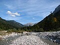
The Rißbach , in the upper reaches of the Enger-Grund-Bach , is a 30 km long wild river in Tyrol and Upper Bavaria that flows through the Riss valley .
It has its origin at the confluence of several source streams in the Enger Grund of the Hinterriß- Eng nature park in the Karwendel in Tyrol . A few kilometers north of Hinterriß the wild river crosses the border with Bavaria and flows into the Isar at Vorderriß near the Sylvenstein reservoir . In order to increase the amount of water available for the Walchensee power plant , the water from the Rißbach has been fed to the Niedernach power plant above the confluence with the Isar through the approximately seven kilometer long Rißbach tunnel since 1951 and then fed into the Walchensee .
Since the precipitation in winter mostly falls as snow, the Rissbach carries a lot of water during the snowmelt in spring and early summer. The stream bed of the lower reaches is around 300 meters wide. Deposited sediments here form large sand and gravel banks that change dynamically.
In September 2014, extensive renaturation measures aimed at restoring the original condition of the Rissbach as part of a two-year project were completed.
The Rissbach is one of the most popular whitewater in Bavaria for whitewater sports enthusiasts . Kurt Sigritz made the first ascent in June 1932 in a folding boat , leaving out the gorge.
course
- Narrow bottom (confluence of several source streams)
- Large maple back
- Riss valley with the village of Hinterriß
- At Vorderriß, the Rissbach flows into the Isar

View from the Kreuzbrücke towards Hinterriß
View towards the Sonnjoch group
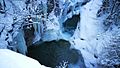
Rissbach fall at the border bridge between Bavaria and Tyrol

Rißbach weir and introduction to the Rißbach tunnel


Web links
Individual evidence
- ↑ a b List of brook and river areas in Bavaria - Isar river area, page 4 of the Bavarian State Office for the Environment, as of 2016 (PDF; 2.5 MB)
- ^ German Hydrological Yearbook Danube Region 2006 Bavarian State Office for the Environment, p. 186, accessed on October 4, 2017, at: bestellen.bayern.de (PDF, German, 24.2 MB).
- ↑ The Rissbach in the Karwendel has been dismantled , orf.at
- ↑ In the "Hadernkahn" one is closer to the water , faz.net