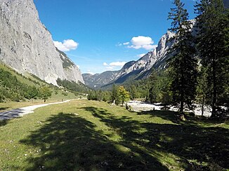
Laliderer brook
| Laliderer brook | ||
|
Dry Laliderer Bach at about 1300 m altitude |
||
| Data | ||
| Water code | AT : 2-6-23-12 | |
| location | Karwendel , Tyrol | |
| River system | Danube | |
| Drain over | Rissbach → Isar → Danube → Black Sea | |
| origin | at the Lalidersalm 47 ° 24 ′ 2 ″ N , 11 ° 30 ′ 53 ″ E |
|
| Source height | 1526 m above sea level A. | |
| muzzle | in the Rißbach Coordinates: 47 ° 27 '0 " N , 11 ° 32' 39" E 47 ° 27 '0 " N , 11 ° 32' 39" E |
|
| Mouth height | 1000 m above sea level A. | |
| Height difference | 526 m | |
| Bottom slope | 81 ‰ | |
| length | 6.5 km | |
| Catchment area | 16.4 km² | |
| Communities | Vomp | |
The Laliderer Bach is a 6 km long wild brook in Tyrol that flows through the Laliderer Tal in the Karwendel .
It rises from the Lalidersalm basin, flows largely in a northward direction, before flowing into the Rißbach in the Riss valley .
